
From deep canyons and golden dunes to lush rivers and turtle beaches, Oman’s landscape has a lot to offer nature lovers and curious travelers alike.
Read MoreA Sweet Stop: The Philippines’ Chocolate Hills
Yet again, Mother Nature has shown us that she is the most skilled artist. In the Chocolate Hills of the Philippines, she demonstrates a mastery of symmetry, balance and color theory.
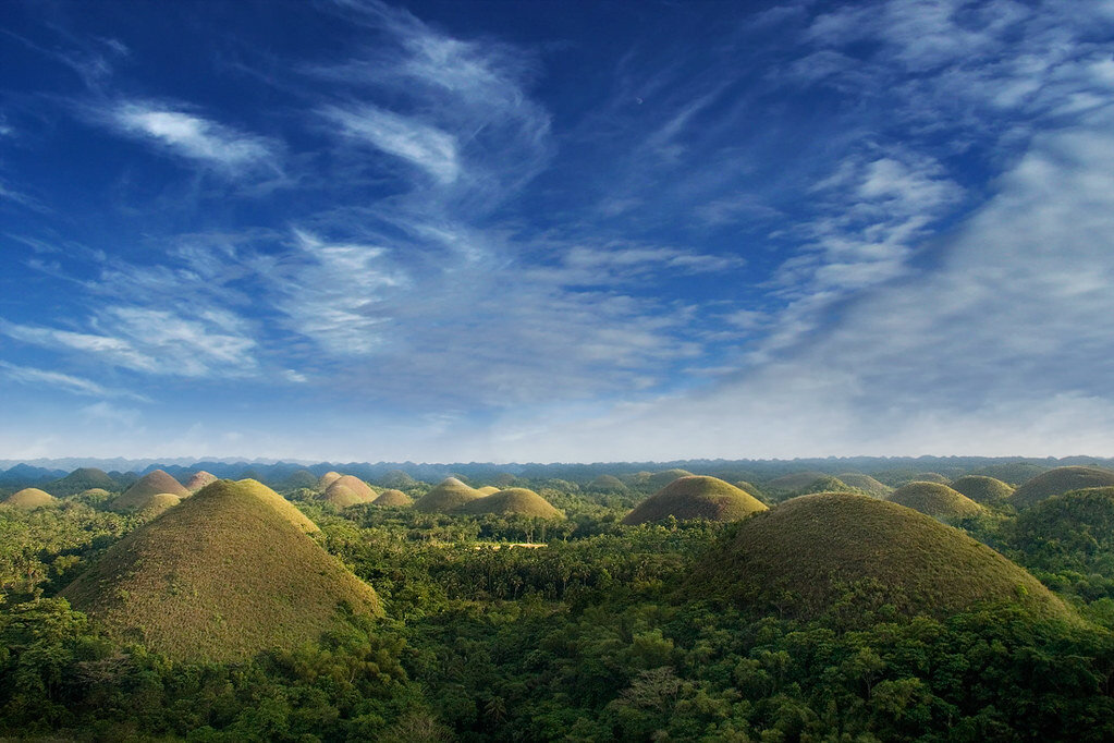
The Philippines’ Chocolate Hills. An diabhal glas. CC BY-NC-SA 2.0.
Spread out over the verdant landscape of Bohol, an island in the Philippines, lies a series of funky natural monuments called the Chocolate Hills. The hills cover about 20 square miles of dense forest, heading through the towns of Batuan, Carmen and Sagbayan. The range consists of well over 1,000 different hills, with some estimates claiming nearly 2,000 in total. Upon close examination, the hills appear to vary notably; most sit between 100 and 150 feet, while the tallest is almost 400 feet.
As sweet as it would be, the hills have no relation to real chocolate, but rather are called “chocolate” for their majestic shade-shifting. During the rainy season, the grassy hills appear soft; the lush layer of short grass gives them a bright, bouncy appearance. However, the dry season bleeds all vibrancy from the grass, washing over the land with a rich chocolate brown. The dry season mutes the vividness of the hills, but looks equally beautiful under the island’s semi-cloudy cobalt skies.
Up close, it is apparent that some of the hills display a more angular appearance, while others seem more compactly round. However, from far away, the hills look completely symmetrical. The result is a view of an expansive landscape marked by natural cones.
Legends of the Land
The abundant greenery finds a parallel in the local folklore; the rich legends of the Chocolate Hills attempt to answer the mysterious origins of the land. Some claim that the legends were purely conjured up as entertainment for children. Others say there’s some truth to the stories.
One story speaks of two giants who engaged in a ferocious fight, in which they threw rocks and sand at each other. The debris of their fight thus resulted in the peculiar sample of the hills seen today.
Another story speaks of immense heartbreak. It is said that a giant fell in love with a woman, who in her inevitable mortality, eventually died. Terribly broken, the giant cried countless tears that solidified into the array of hills.
Lastly, a less popular though comical legend claims that the hills are just piles of dried water buffalo manure.
The Science Behind the Hills
Scientists, too, disagree on how these hills came to be.
One theory claims that the hills are a result of the erosion of underwater limestone; tectonic shifts then broke up these seafloor plates and raised them to land.
The second theory states that the Chocolate Hills are shifted pieces of what was once a series of coral reefs.
Although people may never settle on one solution, it is fair to say that the Chocolate Hills make for a beautiful sight with an equally rich background.

Ella Nguyen
Ella is an undergraduate student at Vassar College pursuing a degree in Hispanic Studies. She wants to assist in the field of immigration law and hopes to utilize Spanish in her future projects. In her free time she enjoys cooking, writing poetry, and learning about cosmetics.
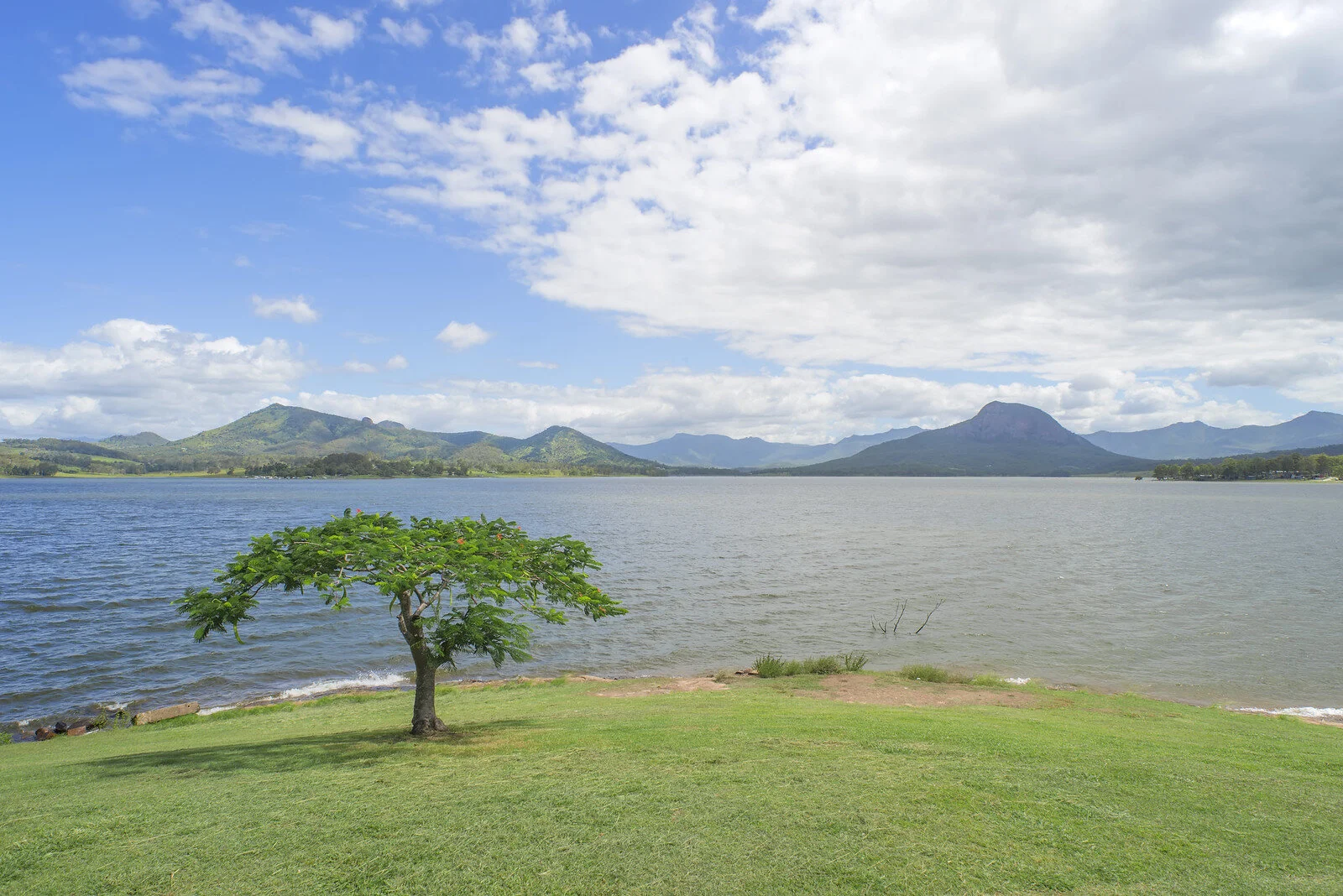
Lake Moogerah in Queensland, Australia. Lenny K Photography. CC BY 2.0.
Australia’s National Parks are Natural Wonders of the World
Australia has long been an escape for those who are seeking to get in touch with nature. While the country is most famous for its semiarid and desert regions, Australia is one of the few countries in the world which can boast a majority of the Earth’s 14 ecoregions—the continent is home to eight.
While Australia is the sixth-largest country in the world, it is one of the most sparsely populated. According to the 2016 census, 23.4 million people call Australia home, with 80% living less than 60 miles from the coast, yielding a population density of 9 people per square mile. This has left the vast majority of Australia’s ecoregions untouched by human development.
Australia’s eight ecoregions range from the very wet tropical and subtropical moist broadleaf forests—found exclusively on the northeast coast of Queensland—to the deserts and xeric shrublands which comprise a majority of the country’s landmass.
This vast diversity in natural habitats makes Australia one of the most biodiverse places in the world. According to the 2009 Numbers of Living Species in Australia and the World report, 147,579 described species had been confirmed, with the estimate for the total number of species which call the continent home at 566,398. A majority of these species are endemic to Australia, ranging from platypi to emus to kangaroos to koalas.
The National Reserve System, Australia’s counterpart to the United States’ National Park Service, is a largely new system of protected areas with the goal of preserving Australia’s vast biodiversity and ecoregions. While the first national park in the country, the Royal National Park in New South Wales, was established in 1879, the National Reserve System did not come into existence until 1992 with the ratification of the Convention on Biological Diversity.
Since then, the National Reserve System has gone on to become a vast network of over 13,000 commonwealth, state and territory protected areas, with a combined landmass of 370 million acres—about 19.75% of the country’s total landmass. Ranging from the expansive Kosciuszko National Park in New South Wales, which includes high summits which regularly see snowfall, to the famous Uluru-Kata Tjuta National Park in the Simpson Desert, Australia’s National Reserve System truly offers something for everyone.
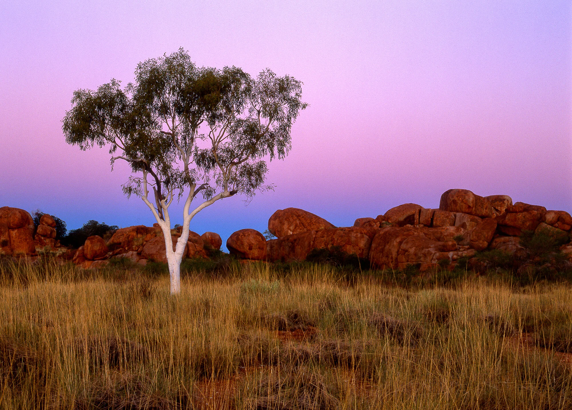
The Devil’s Marbles, a natural rock formation in the Northern Territory. Mark Wassell. CC BY-NC-ND 2.0.
For travelers who are looking to explore the desert and see some unique rock formations, Western Australia’s Nambung National Park cannot be beaten. Located in the Pinnacles Desert, Nambung offers picturesque desert views, beautiful beaches at Kangaroo Point and Hangover Bay, and the aforementioned rock formations called stromatolites. The park can be enjoyed year-round, but the most popular time to visit is in September and October, when its wildflowers are in full bloom.
Located on the southwestern coast of Victoria, Port Campbell National Park is home to breathtaking cliffs which overlook the Southern Ocean and a variety of natural islets, gorges and arches. One of the most famous, the London Bridge, provides the perfect spot to view a population of little penguins come ashore, as well as whale watching in the winter months. Port Campbell can be enjoyed year-round, with different flora and fauna prevalent throughout the various seasons of the year.
For those who can’t get enough of the rainforest, Daintree National Park in Queensland is a popular park for camping and hiking. A part of the Wet Tropics of Queensland, which were designated as a UNESCO World Heritage Site in 1988, the park is home to a variety of unique species, including 430 birds, 23 reptiles and 13 amphibians. While the park is open year-round, the best time to visit is during the drier, cooler months from May to September.

Jacob Sutherland
Jacob is a recent graduate from the University of California San Diego where he majored in Political Science and minored in Spanish Language Studies. He previously served as the News Editor for The UCSD Guardian, and hopes to shed light on social justice issues in his work.
Pretty in Pink: Australia’s Mysterious and Vibrant Lake Hillier
Australia’s Lake Hillier is a vibrant shade of pink enticing adventurous travelers. But to this day there has been no solidified scientific explanation why its color is so intense and it remains a great mystery.
Read MoreA Canvas of Colors: Chile’s Majestic Marble Caves
Mother Nature is often mentioned causing destructive hurricanes, explosive volcanic eruptions and other Earth-shattering natural disasters. Just as easily as she causes destruction, though, she creates unparalleled beauty.

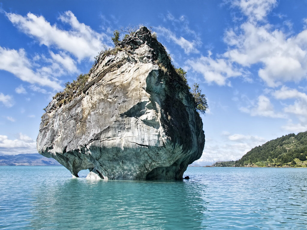
The Marble Caves in Chile. Javier Vieras. CC BY 2.0.
In every region of the world lies some kind of cave system; they range from the awfully eerie such as Hellhole Cave in West Virginia to the wholly tantalizing psychedelic salt mines of Russia. Although all are beautiful in their own way, few turn heads quite like one such cave system in Chilean Patagonia. Situated along one lake is a particularly artistic cavern system called the Marble Caves.
At the Argentina-Chile border lies the majestic General Carrera Lake. The lake is the largest in Chile, with a town called Chile Chico resting on its southern shore. Although the town itself is a quaint and quiet getaway, the treasures of the lake draw most visitors to the area; the massive lake boasts a dynamic palette of mesmerizing shades of sapphire and cobalt. The lake is an incredibly remote glacial lake, making it quite the journey to reach. The lake is surrounded by grand forestry, and enjoys a calm backdrop of snowcapped mountains against an expansive sky. In order to get to General Carrera Lake, visitors must depart from the city of Santiago, then embark on a string of drives totaling about 1,000 miles. From there, visitors can only visit the cave system by boat or kayak.
General Carrera Lake. Dan Lundberg. CC BY-SA 2.0.
Far from the coast of the lake stands a gargantuan block of calcium carbonate from which the caves formed. For over 6,000 years, the lapping waves of the lake eroded the calcium carbonate, slowly but gracefully constructing the Marble Caves. The mineral-rich location is protected from potential mining projects.
The caves earned their name from the masterfully striped walls; the reflection of the waters below create a cerulean painting on them, with complementary hints of yellow, turquoise, black and white. The caves house different cuts and textures due to the patterns of the eroding waves; some parts are rounded while other areas display sharp rocky points. In addition, the open layout of the cave serves it well, providing ample light for the various hues to stay in the spotlight.
The vast range of the cave’s colors is ever changing. In spring, the lower water levels provide a sparkly turquoise-green shade, while the summertime gifts the walls a splendidly deep royal blue.
Time and time again, travelers have found that Mother Nature can create just about any magnificent work of art. The local residents of the lake and any visitor bold enough to endure the journey to it can certainly attest that the Marble Caves are no exception.

Ella Nguyen
Ella is an undergraduate student at Vassar College pursuing a degree in Hispanic Studies. She wants to assist in the field of immigration law and hopes to utilize Spanish in her future projects. In her free time she enjoys cooking, writing poetry, and learning about cosmetics.
VIDEO: THE MAGNIFICENCE OF AZERBAIJAN
Azerbaijan is filled with incredible natural wonders and diverse land formations, yet it’s often overlooked by travelers who are unaware of the beauty it holds. Nicknamed “the land of fire,” it is home to Yanar Dağ (meaning “burning mountain”), a mountain near the Caspian Sea that hosts a naturally burning gas fire that has remained alight for over 65 years. Much of its architecture is built in harmony with the natural landscape; with churches carved into cliff sides and villages nestled in lush valleys. This video takes you through Azerbaijan, past rugged cypress forests, cascading waterfalls, and cliffs that blaze like fire when hit by the sun.
Solidified in Salt: Tanzania’s Lake Natron
Miracles of nature are usually praised for their wondrous beauty, often worked into songs or captured in paintings. However, some miracles of nature harbor an equally eerie side. In Tanzania lies a daunting monster that preys viciously in sinister silence.

Sunlight over Lake Natron. blieusong. CC BY-SA 2.0.
In nearly any social studies class, bodies of water are framed as life-giving and as focal points for the world’s nations. Lakes and rivers are often credited in many civilizations’ lengthy histories for providing a means of transportation and crucial food security. Water itself stands as a symbol of life; ancient Egypt thrived due to fertile soil that would have been absent had it not been for the Nile River. Nonetheless, the complexity of nature has created exceptions to this rule. For instance, in the East African nation of Tanzania lies the deadly Lake Natron.
Lake Natron sits along the East African Rift System in northern Tanzania, and is 35 miles long and about half as wide. Although often photographed for its location under sunlit clouds and for its serene backdrop, the lake is an abyss for almost all wildlife.
Lake Natron is a salt lake, meaning it is incredibly alkaline. The deposits of natron, a chemical salt, flow in from the surrounding hills. This causes the lake’s pH level to be a very basic 10.5; this pH level falls only a bit short of that of ammonia and bleach. The water in this lake only flows inward, so evaporation leaves behind hefty salt deposits. Lake Natron can also reach a steamy state, with the water’s temperature recorded to reach 140 degrees Fahrenheit.

Flamingos on Lake Natron at sunset. virtualwayfarer. CC BY-NC 2.0.
In addition, a peculiar site is found at the shores of the lake. Long lines of dead birds and bats cover the shoreline, with each specimen preserved in a stonelike state. Scientists explain that the high salinity of the lake “freezes” the animals, perfectly preserving them with all of their wings and feathers in place. Nature photographer Nick Brandt chose to turn this site into a fascinating art project. He perches the birds on branches and poses the bats in order to make them look “alive.” With the help of locals, Brandt collected the best specimens and masterfully crafted chilling portraits of the fallen animals. Brandt suspects that the reflective surface of the lake tricks birds into believing it’s open air, leading the birds to drown in the deadly water.
However, to say that the lake is completely absent of life is an act of injustice toward the flocks of flamingos that call the lake their home. Nearly 2.5 million flamingos use the lake’s shores as breeding grounds each year, accompanied by thriving algae and a single resilient species of fish. Although a nontraditional ecosystem, Lake Natron’s niche wildlife web requires balance like any other. Threats to divert nearby rivers into Lake Natron would change its water composition, thereby putting the lake’s wildlife at high risk.
At first glance, Lake Natron appears to be both an example of life imitating art and life imitating horror. Regardless, Lake Natron is the foundation for both important species and scientific study, so there is much to lose if people begin to mistreat it.
RELATED CONTENT:

Ella Nguyen
Ella is an undergraduate student at Vassar College pursuing a degree in Hispanic Studies. She wants to assist in the field of immigration law and hopes to utilize Spanish in her future projects. In her free time she enjoys cooking, writing poetry, and learning about cosmetics.
From Everest to Kathmandu: The Wonders of Nepal
Nepal is most famous for being the home of Mount Everest, one of the 7 natural wonders of the world. However, you don’t have to be a mountaineer to appreciate the beauty of this remote country, which boasts much more than its high peaks and rocky slopes. The monasteries of Nepal demonstrate the deep spirituality of many of its people and their decision to live in harmony with the natural world. Nepal’s main religions are Hinduism and Buddhism, and it has historical significance for both of these faiths. As the world’s only Hindu kingdom, as well as the birthplace of Buddha, Nepal’s religious history is rich and vibrant. This can be seen today in its people, architecture, and majesty of the natural world.
10 Isolated Travel Destinations in the US
Thinking about your next trip once the pandemic eases? This year, try one of these remote spots where isolation will be the theme. From Maine to Montana, explore nature free from crowds.
Read MoreExplore Georgia’s Martvili Canyon
There was a time when the exquisite blue-green waters of Martvili Canyon were only open to Georgian nobles, who would visit to bathe. Now, everyone is welcome to boat and swim here. The picturesque natural wonder is located in Samegrelo, a coastal region of Georgia known for being a historical center of the country’s cuisine and culture. The two-level canyon is thick with moss and other plant life and dotted with waterfalls and caves. And even on the hottest days of summer, the water that pools in the lower level of the canyon is refreshingly cool.
This Great Big Story is by Georgia National Tourism Administration.
THIS ARTICLE WAS ORIGINALLY PUBLISHED ON GREAT BIG STORY