Nearly Extinct Rhino Species Found Only in Indonesia

The Javan Rhinoceros is one of the world’s most endangered species, with only sixty remaining in Indonesia’s Ujung Kulon National Park. 

Javan rhino. Courtesy of Indonesian Ministry of Environment/Forestry.

Javan Rhinoceroses used to be common throughout the continent of Asia, until poaching and habitat loss dwindled the population down to what is now a mere 60-68 rhinos, all found in Ujung Kulon National Park in Indonesia. The poaching of Javan rhinos largely began in colonial times, with the animal being a trophy for hunters. Now, the rhinos are poached primarily for their horns, which are extremely expensive and are sometimes used as status symbols among the extremely wealthy. Javan rhinos were declared extinct in Vietnam in 2010, when the last rhino in the country was poached, and now the only surviving Javan rhinos exist in Indonesia. 

While poaching Javan rhinos is illegal, and they are considered a protected endangered species, reviving the population presents a major challenge for two main reasons. The first is that the extremely small number of surviving Javan rhinos doesn’t allow for much genetic diversity. The second issue is habitat loss as a result of both human intervention and natural disaster. Human activity near Ujung Kulon National Park has interfered with the rhinos’ natural habitats, and the push  for more property development in the area threatens the security of the park. In terms of natural disasters threatening the rhinos’ last remaining habitat, the national park is located in an area that is susceptible to tsunamis and rising water levels as a result of climate change, and also happens to be near an active volcano, Anak Krakatau. Many conservationists are extremely nervous that if one of these natural disasters occured, all hope would be lost for the species even if there were a few survivors, because of the already miniscule genetic diversity within the population. 

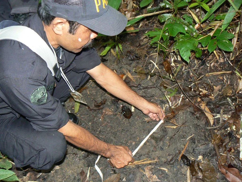
A member of the Rhino Protection Unit measures a Javan rhino’s footprint in Ujung Kulon National Park. U.S. Department of State. CC BY 2.0.

Even without the threat of natural disaster and human interference, Javan rhinos face an existing setback within their protected habitat. An invasive species called Arenga Palm grows in Ujung Kulon National Park. This plant blocks the sun, which prevents the plants that the rhinos eat from growing. The park has made clearing Arenga Palm a priority, but since it is an invasive species, eliminating it from the park entirely is not an easy task.

Ujung Kulon National Park does offer tours, providing an opportunity to ethically see the nearly extinct rhinos. However, since these tours are meant to be non-invasive, there is no guarantee that a Javan rhino will come into view during your time in the park. With that being said, tourists often see traces of the rhinos, such as footprints, like in the photo featured above. 

Get Involved

The best way to get involved with this issue is to raise awareness and money for organizations working to sustain and increase the population of Javan Rhinoceros. Some of these organizations include World Wildlife, which is working on eliminating Arenga Palm and also hopes to one day transfer some Javan rhinos to an area which is not in the danger zone of the volcano Anak Krakatau. Another good organization to support is the International Rhino Foundation, which works directly with the staff of Ujung Kulon National Park. On a more general level, raising awareness about climate change and supporting organizations which respond to extreme weather is a way to get involved with this issue as well as many others, as climate change has only compounded the plight of the Javan Rhinoceros.


Calliana Leff

Calliana is currently an undergraduate student at Boston University majoring in English and minoring in psychology. She is passionate about sustainability and traveling in an ethical and respectful way. She hopes to continue her writing career and see more of the world after she graduates. 

Avoiding the Crowds: 10 Alternatives to the Most Popular National Parks in the United States

There are many sites around the country to visit instead of the most popular national parks, helping to relieve their ecosystems.

Yosemite Valley, one of the highlights of America’s National Park Service. Jeff Krause Photography. CC BY-NC-ND 2.0.

U.S. national parks are more popular than ever. This may sound like a cliché, but it is actually a growing problem. In 2021, America’s national parks received almost 300 million visitors, up 25% from 2020. This increase in visitors is causing strain on the natural environment of those places. In addition, the overcrowding of some national park sites make for an unpleasant experience for visitors. However, many of the visitors to the U.S. National Park Service sites concentrate themselves in a few popular parks. It is possible to have similar experiences  at other sites with less crowds. Here are alternative sites to visit for the 10 most popular national parks in the United States. 

1. Instead of Great Smoky Mountains National Park, go to Grayson Highlands State Park in Virginia.

Great Smoky Mountains National Park. jody.claborn. Public Domain Mark 1.0.

Grayson Highlands State Park. vastateparkstaff. CC BY 2.0.

The Great Smoky Mountain National Park, which straddles the Tennessee-North Carolina border, is the one of the nation’s most popular national parks, receiving an all-time high of 14.1 million visitors in 2021. The park preserves towering mountains and hosts unique ecosystems. Similar landscapes can be found all over the Southern Appalachians, with the Grayson Highlands State Park in Virginia a similar alternative. Grayson Highlands State Park is the home of the state’s highest peak, Mount Rogers, as well as the home of wild ponies. The treeless mountaintops there also make for sweeping views.

2. Instead of Zion National Park, go to Red Rock Canyon National Conservation Area in Nevada.

Zion National Park. Joe Parks. CC BY-NC 2.0.

Red Rock Canyon National Conservation Area. andrew c mace. CC BY-NC-SA 2.0.

Zion National Park in Utah features deep, narrow canyons with colorful layers of rock. Famous hikes in the park include the Narrows, a trek through a narrow slot canyon, and Angel’s Landing, a hike up an exposed promontory leading to wide views of Zion Canyon. Visitors at the second most popular national park are concentrated at two small areas, Zion Canyon and the Kolob Canyons area, due to the rugged landscape. Similar canyon areas with colorful rock layers can be found in Red Rock Canyon National Conservation Area, just outside of Las Vegas. Visitors can explore the canyons and sandstone formations there. For the more adventurous, there are trails that take hikers to the peaks of nearby mountains.

3. Instead of Yellowstone National Park, go to Lassen Volcanic National Park in California.

Yellowstone National Park. James St. John. CC BY 2.0.

Lassen Volcanic National Park. Joe Parks. CC BY-NC 2.0.

Yellowstone, the world’s first national park, is full of unique geothermal features like hot springs and geysers and a variety of rare wildlife. However, it is not the only place in the United States where thermal features are found. In Northern California, Lassen Volcanic National Park also has geothermal features. The most pronounced of those are located in Bumpass Hell, a 3-mile hike from the main park road. As Lassen Peak most recently erupted in 1917, the remnants of that eruption can be seen in the Devastated Area. Volcanic activity has shaped the park, morphing it into an area teeming with geothermal activity.

4. Instead of Grand Canyon National Park, go to Palo Duro Canyon State Park in Texas.

Grand Canyon National Park. Grand Canyon NPS. CC BY 2.0.


Palo Duro Canyon State Park. Thomas Shahan 3. CC BY 2.0.

The Grand Canyon of Arizona is the largest canyon in the United States, where the Colorado River carves out the Kaibab Plateau. Each rim, the North and South, offers a different experience to visitors, with the North Rim being more remote and secluded. The second largest canyon in the United States is the Palo Duro Canyon in Texas, which is a less crowded alternative to the Grand Canyon. The Palo Duro Canyon is formed by the Red River eroding the land, forming colorful strips of rock. Visitors can take part in a glamping (luxury camping) experience at the state park, as well as horseback riding into the canyon.

5. Instead of Rocky Mountain National Park, go to San Juan National Forest in Colorado.

Rocky Mountain National Park. Dusty J. CC BY 2.0.

San Juan National Forest. stefanserena. CC0 1.0.

Rocky Mountain National Park in Colorado is regarded by some as the quintessential Rocky Mountain landscape. However, it only has one mountain higher than 14,000 feet: Longs Peak. The highest concentration of 14,000 feet peaks can be found in the southwest corner of the state in San Juan National Forest. In that wide span of mountains, hikers can seek solitude in the 2,399 miles of trails. There is also a scenic train ride between Durango and Silverton that allows riders to view the heart of the San Juan Mountains without much physical exertion.

6. Instead of Acadia National Park, go to White Mountain National Forest in New Hampshire.

Acadia National Park. moonjazz. CC BY-NC 2.0.


White Mountain National Forest. johncudw2399. CC BY-NC 2.0.

The convergence of mountains and the coast, along with its proximity to several northeastern cities, make Acadia National Park a popular place to visit. The crashing waves along the rocky shore makes for some chaotic scenes, and Cadillac Mountain is the first mountain in the United States to see the sunrise. But, the tallest mountains in the Northeast are located in White Mountain National Forest in New Hampshire. Mount Washington, the tallest mountain in the state, has famously unpredictable weather, being the site of the highest wind speed ever recorded. A cog railway takes visitors up the mountain.

7. Instead of Grand Teton National Park, go to the Wind River Range in Wyoming.

Grand Teton National Park. fortherock. CC BY-SA 2.0.

Wind River Range. LoneWolfMontana. CC BY-NC-ND 2.0.

Grand Teton National Park, located just south of Yellowstone, hosts a number of iconic views, from the rugged peak of Grand Teton itself to the T.A. Moulton Barn. Its lakes are a popular place for boating. While visitors crowd the viewpoints at Grand Teton, the nearby Wind River Range, which is shared by the Shoshone National Forest and the Bridger-Teton National Forest, offers much more solitude. Like Grand Teton, there are no roads in the interior of the Wind River Range, and adventurous travelers go on multi-day treks into the center of the mountain range. Gannett Peak, the tallest mountain in Wyoming, is located in the Wind River Range.

8. Instead of Yosemite National Park, go to the Alabama Hills in California.

Yosemite National Park. Eric Leslie. CC BY-NC-SA 2.0.

Alabama Hills. RS2Photography. CC BY-NC-ND 2.0.

Yosemite National Park offers majestic landscapes shaped by the remnants of glaciers in the Sierra Nevada mountains. Outside of Yosemite Valley, snowy peaks and bare mountains characteristic of the Sierra Nevadas abound. For a more quiet experience of the Sierras, visitors should consider the “other side” of the mountains, more specifically, the Alabama Hills. Located around the town of Lone Pine, those hills just below the highest peaks of the Sierras include unique geological formations. Hikers can also climb Mount Whitney, the tallest mountain in the contiguous United States. Mono Lake, by the town of Lee Vining, also offers a look at an endorheic salt lake.

9. Instead of Indiana Dunes National Park, go to Pictured Rocks National Lakeshore in Michigan.

Indiana Dunes National Park. toddwendy. CC BY 2.0.

Pictured Rocks National Lakeshore. kirsten.elise. CC BY-NC-SA 2.0. 

As one of the newest national parks, only gaining the status in 2019, Indiana Dunes National Park preserves a unique ecosystem in Northwest Indiana just an hour outside of Chicago and South Bend. The beaches along Lake Michigan are popular in the summer and the South Shore Line railroad provides added accessibility by having a few stations in the vicinity. However, Indiana Dunes can get overcrowded in the summer, and Pictured Rocks National Lakeshore on the Upper Peninsula of Michigan provides a more rustic experience. At Pictured Rocks, there are sand dunes like in Indiana Dunes, but also cliffs and waterfalls. While a multi-day hike along the North Country Trail will take intrepid travelers to all of the major sites, most of them are also accessible by car.

10. Instead of Glacier National Park, go to North Cascades National Park in Washington.

Glacier National Park. U.S. Geological Society. CC0 1.0.

North Cascades National Park. i8seattle. CC BY-NC 2.0.

In a place known for its namesake feature, Glacier National Park has relatively few of them. There are only 25 glaciers in the park and the last of them may be gone by 2030 due to climate change. However, there are 300 glaciers in North Cascades National Park, only a bit more than 2 hours away from Seattle. The main road through North Cascades goes through a deep valley with turquoise blue lakes, colored by the minerals carried by the glaciers. The end of the 23-mile unpaved Cascade River Road leads to a trail to Cascade Pass, which rewards visitors with scenic views of Forbidden Peak and Boston Mountain.


Bryan Fok

Bryan is currently a History and Global Affairs major at the University of Notre Dame. He aims to apply the notion of Integral Human Development as a framework for analyzing global issues. He enjoys hiking and visiting national parks.

Source: Avoiding the Crowds: 10 Alternatives to ...

Destination Travel in the Age of Social Media

When it comes to being inspired by social media, Instagram travel feeds are there ready to lure us in. Each feed presents itself like a journey all on their own — with enviously gorgeous images beckoning a traveler onward. It’s a shame to learn then they’re ruining it for the rest of us.

In fact, according to the National Park Service, between 2008 and 2017 places like Yellowstone National Park gained a 40% increase of visitors. And since the onset of COVID-19, those numbers have only got worse. In an interview with The Guardian, the former superintendent of the park, Dan Wenk says, “Our own species is having the greatest impact on the park and the quality of the experience is becoming a casualty.” And national parks aren’t alone, it’s even affecting farmers like those at Bogle Seeds.

Hundreds of people showed up to take photos in front of the sunflowers that grow at Bogle Farms; you’ve all seen those IG worthy shots, like this:

After his farm went viral on Instagram, owner, Mr. Bogle was quoted saying, “I’ve described it as a zombie apocalypse. There were so many cars. People were walking in and around them. No one would move.” People crowded the farm to take selfies and were then accused of doing a lot of damage to flowers.

CBC news in Canada described the sight as “chaos”; and shortly after opening to the public the owners closed it to them for good.

Mr. Bogle is not alone. Just a few miles out from The Grand Canyon, resident of Page, AZ, Bill Diako says that the natural attraction Horseshoe Bend saw a massive spike of visitors when Instagram launched in 2010. He says the numbers grew from a few thousand annual visitors to 100,000 that year. And the phenomenon doesn’t just affect the United States, getting that perfect shot for social media is an international phenomenon.

Tourists posing “holding up” Leaning Tower of Pisa. Pinterest

It’s not just the crowds that are ruining the experience for sustainable travelers. Just like the damage done to the sunflowers at Bogle Seeds, the Great Wall of China has been affected by mistreatment and even theft. Today, if you don’t want to navigate a sea of tourists there, you’ll have to go off-season and in the snow.

Great Wall of China packed with visitors over holiday.

On July 26th Associated Press announced that the Yankee Jims pristine swimming hole in Northern California was closed to motor vehicles due to over crowding. There were about 300 cars spotted parked along the freeway due to the fact that the swimming hole only has 12 spots, which used to suffice. And the local authorities claim that social media is to blame for the surge.

Getting that perfect shot no matter the cost has been a catalyst for movements of change and education. There are even petitions on Change.org to encourage social media users to be more aware of their behaviors when traveling. It would seem that the age of COVID-19 and our need for fresh-air and social distancing has backfired, as the problem only seems to be getting worse. Many would agree there needs to be a sustainable and long term way to travel in the age of social media to prevent the lasting effects on the cultural and historic sites, monuments and lives of people all over the world.


Raeann Mason

Raeann is an avid traveler, digital storyteller and guide writer. She holds a Bachelor’s degree in Mass Comm & Media Studies from the Walter Cronkite School of Journalism & Mass Communication. Passionate about a/effective journalism and cultural exchange, she is an advocate of international solidarity and people's liberation. As the founder of ROAM + WRITE and EIC of Monarch Magazine, Raeann hopes to reshape the culture of travel and hospitality to be both ethically sound and sustainable.

10 National Parks to Visit Outside the US

While most people associate National Parks with the US, there are amazing National Parks to visit around the world. Check out glaciers, tropical wetlands, the oldest desert in the world in these parks in Iceland, Namibia, Thailand, India and more.

Read More

Trekking the W Circuit in Patagonia's Torres Del Paine

The W Circuit draws international hikers year round, giving travelers the chance to backpack through Chile’s famous national park.

The Torres Del Paine national park was first established in 1959. By 1978 the park was designated a world Biosphere reserve by UNESCO. The W Circuit, located in the park, is a multi-day trek providing experienced hikers a taste of backpacking in the southern Chilean region of Patagonia.

The trek is well known for its scenery and the relatively accessible altitude. The lack of technical skills required to hike this circuit draws in people from around the world. The W Circuit is 43 miles long, and typically takes hikers five days to complete. 

The W Circuit not only shows travelers the famous scenery of the national park, but it is home to diverse landscapes that draw in hikers from around the world. Granite spires loom over a glacial lake at the base of the Torres, making the landmark an iconic stop along the hike. The east end of the hike passes by Lake Nordenskjold, a site that impresses hikers with its bright blue color surrounded by forests and peaks. Another notable portion of the hike is the French Valley. Set between mountains, the valley is situated below a glacier with a river running through it. 

Getting to the national park itself can be difficult, as the nearest airport is in Punta Arenas — roughly a three hour drive from the national park. International travelers will most likely have to take more than one flight to reach the park. After reaching the W circuit, however, traveling becomes more accessible for hikers because of the refugios along the route. Refugios are essentially small lodges that hikers can stay in after a day of hiking. There are also campsites that hikers can use, although reserving a spot in advance is recommended.

Travelers set out to complete the W Circuit year round. The weather is unpredictable in general, and while there are peak seasons (typically December through February), hikers are still able to complete the circuit even during the off season. The circuit is the least accessible during the southern hemisphere winter (June, July and August in Chile), as there are often few hikers and accommodations are less readily available, but a prepared hiker can still make the trip.

The trails are consistently marked, and during peak season there are often many hikers on the trails. This makes it possible for hikers to complete the trek without a guide, as it is typically easy to follow the trail and the presence of lodges and other hikers adds an additional level of safety. 


Dana Flynn

Dana is a recent graduate from Tufts University with a degree in English. While at Tufts she enjoyed working on a campus literary magazine and reading as much as possible. Originally from the Pacific Northwest, she loves to explore and learn new things.

Stargazing in Scotland’s Cairngorms National Park

Scotland’s Cairngorms National Park, which has been awarded the status of “International Dark Sky Park” for its low levels of light pollution, is a hot spot for stargazing in the UK.

Looking out over the Cairngorms National Park. Rab Lawrence. CC BY-NC-ND 2.0.

Tomintoul and Glenlivet in Cairngorms National Park (which were awarded international Dark Sky Park status in November 2018) are known for their location as the most northerly Dark Sky Park in the world. And, as one of the darkest skies in the UK, it is the perfect place to see the Perseid meteor showers, making it a hot spot for nighttime photographers and those interested in observing the night sky.

Away from street residential lights, the Cairngorms’ clear skies and northern latitude (the same latitude as Norway and Alaska) means that it’s also one of the best places in the world to see the Aurora Borealis, or the Northern Lights. But for normal stargazing, the best time to visit is during the darker months of the year from October to March.

Although it may be easier to see the stars with a telescope or camera, no equipment is necessary to see the vast expanse of stars in the Cairngorms’ night sky. Even neighboring galaxies and the Milky Way can be seen with just your eyes.

The Cairngorms offer a network of waymarked paths through Glenlivet Estate to guide photographers to many vantage points with big skies and distant horizons. There are also three designated Dark Sky discovery sites in the area.

Cairngorms National Park. Cliff Hellis. CC BY-NC-ND 2.0.

The main reason that such stargazing is possible from the Cairngorms is because of its low light pollution—something that some communities in the park have worked hard to achieve. The Tomintoul and Glenlivet area has even been awarded the desired International Dark Sky Gold Tier status.

Local volunteers in the Tomintoul and Glenlivet area are committed to reducing light pollution through their Dark Skies Project. Volunteers work with farms, distilleries, Moray District Council and households to reduce light pollution by promoting environmentally responsible lighting. Their efforts will bring many benefits to wildlife, energy consumption and human health while preserving the beauty of the night sky.

In addition, Cairngorms’ designation as an International Dark Sky Park will help promote dark skies to a wider audience and bring astro-tourism business to the remote areas of Tomintoul and Glenlivet during the off-season when stargazing is at its best.

Funding for the Dark Skies Project comes from The National Lottery with support from the Cairngorms National Park Authority and Crown Estate Scotland.

Read more about the Dark Skies Project here.


Isabelle Durso

Isabelle is an undergraduate student at Boston University currently on campus in Boston. She is double majoring in Journalism and Film & Television, and she is interested in being a travel writer and writing human-interest stories around the world. Isabelle loves to explore and experience new cultures, and she hopes to share other people's stories through her writing. In the future, she intends to keep writing journalistic articles as well as creative screenplays.

5 Ways to Discover the Distinctive Landscapes of Madagascar

Travelers will surely appreciate the island’s unique biodiversity, but ought to also learn about ongoing social issues in the country.

A scenic view in Madagascar. anmede. CC BY-SA 2.0

Located 250 miles from East Africa, the island nation of Madagascar is one of the most unique places on the planet. Interestingly, the Malagasy people are more closely related to Indonesians than East Africans; they have also developed cultural and linguistic ties with West Africa due to French colonialism. Madagascar is especially known for its incredible biodiversity. At least 80% of Madagascar’s flora and fauna cannot be found anywhere else on Earth, including many species of lemurs, chameleons and butterflies. 

Despite the island's idyllic landscapes, Madagascar’s recent history has been anything but peaceful. After gaining independence from France in 1960, political unrest, countless coups and widespread corruption have dominated the headlines. The most recent coup in Madagascar occurred in 2009 and resulted in massive social unrest and international sanctions, further crippling the country’s economy. Currently, Madagascar is the poorest country in the world that is not mired in conflict, with 92% of the country’s population living on less than $2 a day. 

Deforestation and environmental degradation remain pressing concerns as well. Many of Madagascar’s lush forests have been chopped down to make way for rice paddies and to harvest wood for export. Currently, significant forests only remain on the northern and eastern portions of the island. Southern Madagascar has been experiencing severe drought since 2014, which has left up to 1 million people without food. The country also continues to be ravaged by the COVID-19 pandemic with a  Level 4 (very high) level of transmission according to the U.S. Centers for Disease Control and Prevention. 

Despite Madagascar’s turbulent history, the country is one of the most beautiful in the world with stunning landscapes and kind people. Read on to learn about key sites to visit once Madagascar fully reopens. 

A mother ring-tailed lemur with her baby. Allan Hopkins. CC BY-NC-ND 2.0

1. Lemurs

Starting with Madagascar’s furriest (and cutest) attraction, these primates cannot be found anywhere else on Earth. Although they are likely related to monkeys, the exact origin of the species is not known. There are over 100 species of lemurs in total, some of the most notable being the ring-tailed lemur with its long black-and-white striped tail, the sifaka and the elusive aye-aye. There are many national parks where visitors can observe these animals in their natural habitat, including Isalo and Zombitse-Vohibasia. 

Avenue of the Baobabs in Madagascar. Rod Waddington. CC BY-SA 2.0

2. Avenue of the Baobabs

Baobabs are some of the most distinctive trees found anywhere in the world. Six species of baobab grow in Madagascar. Also known as the “mother of the forest” in Malagasy, they have large, bulbous trunks that store water, allowing baobabs to survive in dry climates. Many of Madagascar’s giant baobabs can be found along the Avenue of the Baobabs, located roughly 12 miles from Morondava. Travelers will have the opportunity to walk among these magnificent trees, some of which are over 800 years old!

A beautiful beach in Madagascar. Tatogra. CC BY-SA 2.0

3. Nosy Be

Nosy Be is the largest of a dozen small islands off the northwestern coast of Madagascar. These islands are teeming with rich marine life and offer perfect opportunities for snorkeling, diving and kayaking. Known as Ambariobe, or “the great island” in the local language, Nosy Be is a perfect launching point for cruises traveling to the other islands. Other notable islands in the region include Nosy Komba, often known as lemur island, and Nosy Sakatia, which contains both winding forest trails and pristine dive sites

A humpback whale. Krishna Naudin. CC BY-SA 2.0

4. Humpback Whale Sightings 

Humpback whales can be spotted off the eastern coast of Madagascar annually from June to September. Recognized by their black backs and white bellies, humpback whales arrive in Madagascar for the mating season after traveling over 900 miles from the Antarctic coast. If you’re lucky, you may even see a mating dance or a live birth! Ecotourism organizations such as Cetamada allow travelers to view humpbacks up close in an ecologically responsible way. Popular destinations for whale sightings include Nosy Be, Ile Sainte-Marie and Antongil Bay. 

Tsingy formations in Madagascar. Oliver Lejade. CC BY-SA 2.0

5. Tsingy de Bemaraha National Park

Characterized by fossilized shell formations, these unique structures known as “tsingys” can be found in several regions of Madagascar. Tsingy de Bemaraha National Park is one of the best places to see these interesting structures and is located west of Madagascar’s capital, Antananarivo. The tsingy formations in the Melaky and Diana regions of Madagascar are both UNESCO World Heritage Sites and deserve a visit. 

Although Madagascar faces many environmental and social dilemmas, the country has strong potential and an undeniable natural beauty. 


Megan Gürer

8 Surprisingly Vibrant Desert Destinations

Deserts are much more than the beating sun and rolling sand dunes we often picture. These eight destinations showcase the incredible natural beauty of the desert, from salt flats and chalk formations to mountains and glaciers. 

Though deserts are often thought of as just hot, dry expanses of sand, they come in a variety of climates and landscapes and hold some of the world’s most fascinating natural formations. Deserts “are areas that receive very little precipitation,” making them arid but not necessarily hot and sandy. Many deserts are mountainous, and others are large expanses of rock or salt flats. Though their arid environment makes water in deserts scarce, they are far from lifeless. Plants and animals, including humans, have adapted to desert life. One-sixth of the Earth’s population lives in deserts, which are found on every continent. 

These eight desert destinations range from freezing to boiling in temperature and are all unique, with their own attractions and plant and animal life. Each of these stunning deserts is worth a visit, and they may change your opinion of the desert as a stark, lonely place to one of beautiful landscapes blooming with culture, history and life. 

White and Black Deserts, Egypt 

Located just a few hours from Cairo, Egypt’s White and Black deserts are two stunning and underappreciated visitor attractions. The White Desert is located in the Farafra Depression, a section of Egypt’s Western Desert, and boasts some of the most unique geological landscapes in the country. Incredible wind-carved white chalk formations rise from the sand in the shapes of towering mushrooms and pebbles, giving the White Desert its name. The White Desert stretches over 30 miles, and the most visited area is the southern portion closest to Farafra. To the north of the White Desert is the Black Desert, where volcanic mountains have eroded to coat the sand dunes with a layer of black powder and rocks. In the Black Desert, visitors can climb up English Mountain and look out over the landscape. The Egyptian Tourism Authority recommends booking a tour to explore the deserts in depth, and travelers can even stay in the White Desert overnight. 

Joshua Tree National Park, California 

Joshua Tree National Park in Southern California is where two different desert ecosystems meet. Parts of the Mojave and the Colorado deserts are both found in Joshua Tree, along with a distinctive variety of plant and animal life. The Joshua tree, the park’s namesake, is the most identifiable of the plants, with its twisted, spindly branches and spiky clusters of greenery. Some of the park’s most popular attractions are Skull Rock; Keys View, a lookout with views of the Coachella Valley and the San Andreas Fault; and Cottonwood Spring Oasis, which was a water stop for prospectors and miners in the late 1800s. Joshua Tree National Park has roughly 300 miles of hiking trails for visitors to explore. The park is open 24 hours and can be visited at any time of the year, but visitation rises during the fall due to the cool weather and is at its height during the wildflower bloom in the spring. 

Atacama Desert, Chile 

Trips to the Atacama Desert in northern Chile are likened to visiting Mars on Earth. The dry, rocky terrain is so similar to that of Mars that NASA tests its Mars-bound rovers here. The Atacama Desert, the driest desert on Earth, spans over 600 miles between the Andes and the Chilean Coastal Range. Some weather stations set up in the Atacama have never seen rain. Despite its dryness, the desert is home to thousands of people, as well as plants and animals. People have been living in the Atacama Desert for centuries; mummies were discovered in the Atacama dating back to 7020 B.C., even before the oldest known Egyptian mummies. Attractions in the Atacama Desert include El Tatio geyser field, the Chaxa Lagoon, the Atacama salt flats, and sand dunes over 300 feet tall. The Atacama Desert is also said to have some of the clearest night skies in the world, making it perfect for stargazing. It is best to avoid a trip to the Atacama during the summer months, as the high temperatures make for a sweltering visit. 

Salar de Uyuni, Bolivia 

The world’s largest salt flat, Salar de Uyuni, covers 3,900 square miles in the southwestern corner of Bolivia. Salar de Uyuni is so large it can be seen from space and holds an estimated 10 billion tons of salt. Beneath the salt flat is approximately 70% of the world’s lithium reserves. This lithium is carefully extracted and used for powering laptops, electric cars and smartphones. Salar de Uyuni is surrounded by scenic lakes, geysers and rock formations, and is one of the world’s most beautiful and untouched natural landscapes. Tours of Salar de Uyuni take visitors to the Valley of Rocks; Morning Sun, which is home to geysers and mud pots; Colchani, a salt-processing village; and the Polques Hot Springs, where travelers can soak in warm thermal water. The landscape of Salar de Uyuni changes based on the seasons, so travelers should plan their visits around what they want to see. From July to October, access to all sites of Salar de Uyuni is unrestricted, but during the rainy season from December to April, visitors may be able to witness the salt flat’s famous mirror effect, where a thin layer of water over the salt transforms the land into the world’s largest mirror. 

Tanque Verde Ranch, Arizona 

Located just outside of Tucson, Arizona, near Saguaro National Park and the Rincon Mountains, Tanque Verde Ranch gives visitors “the ultimate dude ranch experience.” The ranch sprawls over 640 acres and stocks over 150 horses. Visitors to the ranch can get a real-life cowboy experience, including horseback riding and team penning. Riders of all experience levels will find something to do at Tanque Verde, where visitors can take beginning, intermediate and advanced lessons and then go on a sunrise or sunset trail ride through the Arizona desert. Tanque Verde Ranch offers kids’ riding activities too, as well as activities for non-riders such as yoga, mountain biking, fishing, swimming and pickleball. Visitors should pack long pants and closed-toe shoes if they plan to ride, and casual wear is appropriate for all non-riding times. Trips to the ranch usually last around four days, and visitors stay on the property. Tanque Verde Ranch is open to visitors year-round. 

Gobi Desert, Mongolia 

Spanning most of southern Mongolia and its border with China, the Gobi Desert contains stunning views and years of history. The region was once populated by dinosaurs, and some of the best-preserved fossils in the world were found near the Flaming Cliffs of Bayanzag. The Gobi Desert showcases a variety of natural beauty, from towering sand dunes to incredible white granite formations. Dry desert plants that come to life after rain make the Gobi unique, as well as ”saxaul forests” made up of sand-colored shrubbery. Visitors to the Gobi Desert should explore the Khongor Sand Dunes, an area that offers rocky and mountainous terrain in the south, dry and barren terrain in the center, and several oases in the north. Other major attractions are the Flaming Cliffs of Bayanzag, where red clay seems to glow in the sun, and the Gobi Waterfall, which looks like a city in ruins but is a completely natural formation. The best time to visit the Gobi Desert is either in late spring or in autumn, when the weather is neither too hot nor too cold.

Nk’Mip Desert, Canada 

Also called the Okanagan Desert, Canada’s Nk’Mip Desert contains the most endangered landscape in Canada. Located in Osoyoos in British Columbia, the Nk’Mip Desert Cultural Center is a 1,600-acre area of the Okanagan Desert managed by the Osoyoos Indian Band, and is the only fully intact area of desert in Canada. The desert is situated in a semiarid microclimate. The cultural center was designed to be eco-friendly and resembles the traditional winter homes of the Osoyoos Indian Band. Visitors can explore the desert on walking trails, which are surrounded by sage, prickly pear cactuses and antelope brush, as well as sculptures of desert creatures and native peoples by Smoker Marchand. The trails take visitors through a traditional Osoyoos village, where they will find a traditional sweat lodge and pit house. Many visitors prefer to explore Nk’Mip Desert in the summer due to the region’s relatively cold winters. 

Patagonian Desert, Argentina and Chile

The Patagonian Desert is South America’s largest desert and the seventh-largest in the world. It covers parts of southern Argentina and Chile, and is a cold desert, sometimes reaching a high temperature of 68 degrees Fahrenheit. The Patagonian Desert is home to two national parks: Torres del Paine National Park in Chile and Los Glaciares National Park in Argentina. Torres del Paine and Los Glaciares aren’t typical desert environments, but since the Patagonian is a cold desert, its landscape is different from that of most deserts. Before the Andes were formed, the Patagonian Desert was likely covered by temperate forests, so the region containing the desert, Patagonia, is extremely ecologically and geographically diverse. Torres del Paine National Park is known for its towering granite structures, which were shaped by glaciers. Los Glaciares is home to large glaciers, as well as scenic mountains, lakes and woods. The Cueva de las Manos, or “Cave of Hands,” is a series of caves in Argentinian Patagonia which are filled with paintings of hands dating back to 700 A.D., likely made by ancestors of the Tehuelche people. Tehuelche people live in Patagonia today, some still following a nomadic lifestyle. The best time to visit Patagonia is generally said to be in the summer (December to February), when the days are warm and the fauna is in full bloom, but there are merits to exploring the area at all times of year. 


Rachel Lynch

Rachel is a student at Sarah Lawrence College in Bronxville, NY currently taking a semester off. She plans to study Writing and Child Development. Rachel loves to travel and is inspired by the places she’s been and everywhere she wants to go. She hopes to educate people on social justice issues and the history and culture of travel destinations through her writing.