The Most Endangered Species of Penguin

The yellow-eyed penguins of New Zealand are the rarest species of penguins in the world.

Group of Yellow-Eyed Penguins. Chris Gin. CC BY-NC-ND 2.0

Known as hoiho penguins in the Māori language of New Zealand, yellow-eyed penguins are the most endangered penguin species. There are estimates of fewer than 3000 of them left in the wild. In the past 30 years alone, the population has decreased by 50-75%. 
Yellow-eyed penguins are easily identifiable, as they have yellow feathers around their eyes. It is a unique trait they have, along with the band of yellow that extends around their heads. Like other penguins, yellow-eyed penguins are predators, eating mostly fish and crustaceans. Adult birds generally have no land predators, but the chicks and eggs are in danger from animals like cats, dogs, ferrets and stoats. This is also common in Antarctica, where penguin chicks and eggs are vulnerable to other Antarctic birds, but the adults have almost nothing to fear from the other animals. In the water, however, yellow-eyed penguins are in danger from large marine predators, such as sharks and seals. Penguins have no defense mechanisms, so they mostly rely on their speed and maneuverability in the water to survive. Yellow-eyed penguins can swim up to 12.4 miles per hour. In comparison, the average human can swim around 2 miles per hour. If necessary, penguins also avoid ocean predators by jumping up on land. Like every other species, yellow-eyed penguins have a black back and white stomach to camouflage underwater. Their backs blend in with the dark depths for creatures above looking down on them, and their stomachs blend in with the surface for creatures looking up at them. 

Yellow-Eyed Penguin. Bernard Spragg. CC0 1.0.

Yellow-eyed penguins mate for life and breed two eggs a year. Their average lifespan is 23 years, and these penguins start breeding at different times. They reach sexual maturity around two years of age, and most females begin breeding then. With males, however, it is more common to start breeding at three. The parents will incubate the eggs until they hatch, and then raise the chicks for around twelve months. Their nesting sites are in the bushes and shrubs along New Zealand’s coast, though deforestation has become a major threat to them. Humans have been clearing out land to make room for new houses or grazing fields for their animals, so the penguins have been forced to find new homes. The loss of their natural nesting habitat and the introduction of predators such as dogs and cats have contributed a lot towards why yellow-eyed penguins are endangered. There is also a high chick mortality rate, and some penguins get caught in gillnets, which lead to their deaths. The other major contribution to their decline is the food shortage due to global warming. 
There are two main yellow-eyed penguin populations: the northern and southern ones. The size of each population is determined by how many breeding pairs there are, and in 1991, the northern population had 741 pairs. By 2020, it has decreased into a population of 233 breeding pairs. This decline has been mostly due to lack of food, diseases and predators. The northern population is spread out over ​​South Island, Stewart Island and various other ones near to them.
The southern population, on the other hand, has been doing much better. In 1992, the estimated number of breeding pairs was 400, and in 2017, the number increased to 570. The southern population is divided into two colonies, one on Auckland Island and the other on Campbell Island. Though the penguins on these islands are doing much better than their northern counterparts, the overall population of yellow-eyed penguins is still decreasing. 

Solitary Yellow-Eyed Penguin. Ben. CC BY-ND 2.0

To Get Involved:

There are multiple conservation organizations that exist in order to protect these penguins. One such organization is The Yellow-Eyed Penguin Trust, specifically focused on protecting the habitats and livelihoods of these birds. The easiest way to help them is by donating to them through their website, but it is possible to volunteer for them, if you live in New Zealand. Their office is based in Dunedin, but there are penguin preserves in other parts of the country. To learn more about the Yellow-Eyed Penguin Trust, click here
Penguin Place is another organization dedicated to helping yellow-eyed penguins. They are the first conservation program funded entirely by tourism. They do take donations on their website, but most of their funds come from tours. Their funding comes from guided tours on penguin reserves and the money goes to preserving their habitats, helping sick or wounded penguins and controlling predators. To learn more about Penguin Place, click here.


Katherine Lim

Katherine Lim is an undergraduate student at Vassar College studying English literature and Italian. She loves both reading and writing, and she hopes to pursue both in the future. With a passion for travel and nature, she wants to experience more of the world and everything it has to offer.

7 Stunning Caves Worth Exploring

Though caves often hold a fearsome reputation, they have a myriad of captivating natural features and intriguing histories. 

Caves often get a bad reputation: cold, dark, damp and uninteresting, or even frightening. In reality, caves offer snapshots of history, unusual natural structures, and examples of remarkable biodiversity. There are thousands of caves on Earth, and even more that are yet to be discovered. Each cave is unique, with specific natural formations that cannot be found anywhere else. Here are seven incredible caves to add to your list of must-see sights. 

1. Reed Flute Cave, China 

Called “the Palace of Natural Art,” Reed Flute Cave is known for its impressive stone curtains and pillars. Reed Flute Cave is located just 3 miles from downtown Guilin, China, and has been an attraction for centuries. Seventy-seven inscriptions of poems and travel descriptions can be found around the cave, and the oldest dates back to 790 A.D., the era of the Tang dynasty. There are inscriptions from the Tang, Song, Yuan and Ming dynasties, written by monks, poets, scholars and tourists from all over China. Today, the cave is lit by many multicolored lights hidden in its natural cracks and crevices, which cast a bright rainbow glow around the dark space, giving cave visitors a surreal and breathtaking experience. The cave was forgotten for years until its rediscovery in 1940, when a group of Chinese refugees stumbled upon it while fleeing from Japanese forces. During World War II, the cave’s large chamber, called the “Crystal Palace of the Dragon King,” was used as a bomb shelter. The cave regained popularity after its rediscovery at the end of the war, and was officially opened to the public in 1962. 

2. Waitomo Glowworm Caves, New Zealand 

Visitors to the Waitomo Glowworm Caves will take a trip into the past by exploring a cave over 30 million years old. The cave, located in Waitomo on the North Island of New Zealand,  is praised as one of New Zealand’s best natural attractions. It contains an underground river, towering rock formations, and thousands of shimmering glowworms. The Glowworm Caves have been an attraction for over 130 years. These limestone caves formed at the bottom of the ocean millions of years ago. Local Maori communities knew about the caves, but they were first explored in 1887 by Maori Chief Tane Tinorau and English surveyor Fred Mace. After discovering the natural beauty of the caves, Chief Tinorau opened the caves to tourists in 1889. Many of the guides for tours today are descendants of Chief Tinorau. Guides take visitors on walking tours through the caves, as well as boat tours through the glowworm grotto. These boat tours take visitors to the center of the grotto, where they can look up in awe at the luminescent glowworms covering the cave walls and ceiling.  

3. Mendenhall Ice Caves, Alaska

Just 12 miles outside downtown Juneau lies Mendenhall Glacier, known as the “Glacier Behind the Town.” Inside the glacier are the Mendenhall ice caves, passageways formed by water flowing through the glacier. These caves vary in size from tiny openings visitors have to squeeze through to giant caverns. Mendenhall Glacier was first explored in 1794 by Joseph Whidbey, a member of the British Royal Navy serving on Capt. George Vancouver’s 1791-95 expedition of the Pacific Northwest coast. To visit the caves, travelers can hike through the Tongass National Forest and then across the glacier, or they can canoe across Mendenhall Lake to the glacier. Both options offer breathtaking views of the glacier and surrounding landscapes, and both are somewhat strenuous but well worth the effort. Inside the caves, visitors are immersed in the cool blue shades of light coming through the glacier and can explore ever-changing ice formations. The caves change as the ice melts, so each visit to the Mendenhall ice caves is unique. The presence of the caves is also inconsistent and typically seasonal, so visitors should be sure to check on the status of the caves before planning a trip. 

4. Barton Creek Cave, Belize

To discover the wonders of Barton Creek Cave, visitors will have to board a canoe. Barton Creek Cave is located east of San Ignacio along the western edge of Belize. It is a wet cave because it has a cave river running through it, and paddling along this tranquil river is the only way to take in the cave’s majesty and history. It is the largest river cave in Belize and contains evidence of ancient Mayan culture. The cave is natural, but archaeologists have identified a number of areas they believe were purposefully modified by the Mayans to improve access to the cave. These modifications include natural formations of flowstone broken to allow access to a rimstone pool and holes drilled by Mayan tools, likely to serve as handholds or to attach climbing ropes. Ten ledges made by the Maya line the cave walls, where archaeologists have discovered thousands of pottery shards, most of which are from large jars called ollas, and a number of stone tools. These discoveries have helped archaeologists determine the use of the cave during Mayan times; it was likely the site of ritual activity and worship. The Maya regarded caves as sacred sites, and the artifacts found in Barton Creek Cave reflect this view. Tours through the cave offer visitors the opportunity to witness incredible natural formations and to learn how the ancient Mayans interacted with the cave. 

 5. Hang Son Doong, Vietnam 

For travelers who want to explore a cave but worry about darkness and small spaces, Son Doong Cave in central Vietnam is the perfect place to visit. Son Doong has the largest cross section of any cave in the world, reaching over 5 miles long, 650 feet wide and 490 feet tall. In some areas, the limestone ceiling of the cave grew weak and collapsed, creating huge skylights and allowing areas of lush vegetation to grow inside the cave. It was formed millions of years ago by the Rao Thuong River eroding limestone. Son Doong Cave was initially discovered in 1990 by a local man named Ho Khanh, who stumbled upon the entrance while searching the area for food and timber. He then returned home and no further exploration of the cave occurred until Howard and Deb Limbert, members of the British Cave Research Association, heard Ho Khanh’s story and urged him to find the cave again. In 2008, he successfully rediscovered the cave, and a survey was conducted by Howard Limbert and a group of British cavers. The cave opened to the public in 2013. Visitors are sure to be impressed by the sheer size of the cave, as well as its natural formations, river and distinctive vegetation growth. 

6. Puerto Princesa Underground River, Philippines

Located on Palawan, the westernmost island in the Philippines, Puerto Princesa Subterranean River National Park is home to old-growth forests, wildlife and an expansive limestone cave system. The Puerto Princesa Underground River, as it is commonly known, flows for over five miles through beautiful caverns and eventually meets the sea. Visitors can take underground river tours on paddleboats to see the stunning cave formations and limestone cliffs, as well as a variety of native animal species. There are records of the Puerto Princesa Underground River dating back to 1898, but it is believed to have been known to early inhabitants of the Philippines and investigated by foreign explorers prior to that time. The area was established as an official attraction in 1971, and the cave system is still being explored. In 2010, researchers discovered a large cave dome above the underground river, with more river channels and access to an even deeper cave. The Puerto Princesa Underground River offers an abundance of fascinating natural formations to explore. 

7. Shell Grotto, England 

Shell Grotto is one of England’s most mysterious sites, encompassing over 70 feet of tunnels under the seaside town of Margate. These caves were discovered by chance in 1835, when a man excavating his new land stumbled upon them. Sprawling mosaics made of mussel, oyster, whelk and cockle shells cover every wall of the tunnels. Historians are unsure of who built Shell Grotto, or why. Theories range from Shell Grotto being a place of worship to a simple display of extreme wealth to the meeting room of a secret society. The elaborate shell designs offer little explanation, displaying swirling patterns that can be interpreted as a number of different things. Shell Grotto is a tremendous work of art, and the questions surrounding its origin and purpose add a layer of intrigue that draws visitors from around the world. 


Rachel Lynch

Rachel is a student at Sarah Lawrence College in Bronxville, NY currently taking a semester off. She plans to study Writing and Child Development. Rachel loves to travel and is inspired by the places she’s been and everywhere she wants to go. She hopes to educate people on social justice issues and the history and culture of travel destinations through her writing.

The Unique Landscapes of New Zealand's Milford Sounds

Milford Sound located in Fiordland National Park’s diverse landscape has been preserved for years, drawing travelers from around the world.

Milford Sound is often considered a destination for immersing oneself in nature. Located on the west coast of the southern island, the sound is situated in New Zealand’s Fiordland National Park. A sound, by definition, is a valley filled with seawater. Milfrorf Sound, however, is formed from glacial water, which technically makes it a fiord. Milford Sound has attracted visitors for centuries, but the history of the sound dates back more than 1,000 years. 

The Māori first discovered the fiord, using the land for fishing, hunting and mining pounamu (green jade). According to Māori legend, the sound was carved by Atua, a godly figure who split the cliffs surrounding the sound. The Māori named Milfrod Sound Piopiotahi in refrence to a native bird. A Māori tells the story of a piopio bird flying over the sound after the legendary figure Maui died while pursuing immortality.

In 1877, a man from Scotland settled in Milford Sound, opening the first hotel with his wife. Visitors in the late 19th century and early 20th century were only able to reach the sound through a walking path, Milford Track. In 1954, a tunnel was drilled through the rock surrounding the sound, bringing new road access. With the building of the road, Milford Sound became much more accessible to travelers and has drawn large numbers of visitors from around the world. 

Milford Track is still available to explore today within the boundaries of the national park. The path is over 30 miles long and typically takes four to five days to complete. Each night, hikers can stay at a hut along the route before continuing the next day. The trail starts at the head of Lake Te Anau and ends a short boat ride away from Milford Sound. There are also many different day-hikes that visitors can complete to see the park as well as a variety of boat tours. The area experiences heavy rainfall year round, which provides the lush environment and abundance of waterfalls. Kayaking is also popular among visitors, as it allows people to explore the water in an eco-friendly way. 

One of the iconic sites of Milford Sound is the Mitre Peak. The mountain sharply rises up from the water, reaching a height of more than 5,000 feet. Additionally, the area is well known for its waterfalls. Lady Bowen Falls, the tallest permanent waterfall in the park, feeds directly into the fiord. Accessible by boat and a short hike, the falls are another important landmark in Milford Sound.

Milford Sound is not just known for its beautiful scenery and nature, but is an important aspect of New Zealand's heritage. The national park is a UNESCO World Heritage Site recognized for its unique landscapes and wildlife. The area is protected by several laws, including the Conservation Act of 1987, to ensure that the area will continue to prosper.


Dana Flynn

Dana is a recent graduate from Tufts University with a degree in English. While at Tufts she enjoyed working on a campus literary magazine and reading as much as possible. Originally from the Pacific Northwest, she loves to explore and learn new things.

Slope Point and Champagne Pool: Exploring New Zealand’s Wild Wonders

Sometimes nature is simple: vibrant sunsets, rays of warming moonlight or bouncing ocean waves. Other times, however, nature shocks and stuns. New Zealand houses two such examples: the odd site of Slope Point and the equally eerie Champagne Pool.

Slope Point with sheep. Seabird NZ. CC BY-ND 2.0. 

Slope Point

Perhaps most descriptions of the wonders of wind speak of a gentle breeze or freshly blowing air. On the southernmost tip of New Zealand’s South Island, the winds are instead far from calm; the violently whipping winds gave one area the name “Slope Point.” Situated along a steep cliff at the island’s southern edge, Slope Point is an ideal spot for those mystified by science. The ocean winds are violent and unrelenting to the area’s trees. The wind provides a scary picture of nature’s true power, blowing away anything that may come in its path. The location of Slope Point forces the trees to become the first victims of the winds. As a result, the tall trees are bent at an odd angle, making them seem as if they were purposely posed. Although few people live in the area, local farmers planted the trees to provide shelter from the wind for their herds of sheep. 

Photographs of the area offer profound inspiration for artists: the odd trees bend against a gray background striped with warm rays of sun. Although the area hosts an eerie feel, it is surely one underlined with the beauty of Mother Nature’s masterful hand. 

Champagne Pool

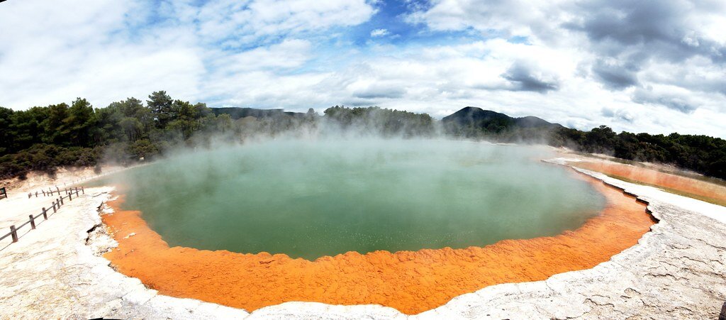
Boiling Champagne Pool. t3rmin4t0r. CC BY 2.0. 

Far north of Slope Point lies the mystical Champagne Pool on New Zealand’s North Island. Although an uncanny site, Champagne Pool is only one of many geothermal spots peppering the area around the city of Rotorua. The surrounding area, called Wai-O-Tapu, is known for its geothermal sites carved throughout the landscape. The strips of active volcanic sites and geothermal pools have created an admittedly scary yet magnificent look into what lies just beneath our feet. 

Champagne Pool is a captivating hot spring that stretches over 200 feet and is about equally as deep. A hydrothermal eruption caused this crater, which boils at over 160 degrees Fahrenheit, to form about 900 years ago. The hot spring earned its name from the presence of carbon dioxide that causes it to bubble like Champagne. Although seemingly uninhabitable, the hot spring teems with a rich microbial ecosystem. Additionally, striking photos of the site capture the vibrancy of the pool’s outer rim. Its neon orange strip is caused by antimony deposits that harden on the cooled rim of the pool. The surrounding grounds are equally rich in minerals; gold, mercury and silver are found in nearby rock beds. 

Whether one is an artist, a scientist or an adventurous visitor, both Slope Point and Champagne Pool stand as equally inspiring trips. 


Ella Nguyen

Ella is an undergraduate student at Vassar College pursuing a degree in Hispanic Studies. She wants to assist in the field of immigration law and hopes to utilize Spanish in her future projects. In her free time she enjoys cooking, writing poetry, and learning about cosmetics.

Aotearoa: Reclaiming Maori Language and Identity in New Zealand 

Compared to Indigenous groups around the world, the Maori in New Zealand enjoy more agency because of the Treaty of Waitangi, a founding document that recognizes Maori ownership of land and their subsequent autonomy in the country’s government. However, some feel that more can be done to create a bicultural and celebratory society—one that puts the Maori language at the forefront. 

A performance of the haka, a traditional Maori dance. Matthieu Aubry. CC BY-NC-SA 2.0.

New Zealand is an island country known for its scenic views, its native kiwi bird and its iconic role as the fictional Middle Earth. The country, named Aotearoa (meaning “long white cloud”) in the Maori language, is also steeped in rich history and culture.

Before European settlement, New Zealand was home to the Maori, one of the region’s many Polynesian ethnic groups. According to their oral histories, the Maori first voyaged from present-day Tahiti. They arrived and began inhabiting Aotearoa as early as 1300 A.D. Once settled, the Maori formed tribal societies. Their culture revolves around respect for the natural environment. The Maori also possess elements of a warrior culture—they craft unique performative arts such as the haka, a war dance turned into a ceremonial celebration.

Although the first Europeans—Dutch navigators—made contact with the Maori in 1642, the Maori way of life was not significantly impacted until the late 1700s. With the arrival of British Capt. James Cook, the scramble for New Zealand ensued. As nearby French voyagers and ungoverned sealers and whalers reaped profits from the islands’ natural resources, the British moved to make New Zealand a colony in 1840.

Reconstruction of the signing of the Treaty of Waitangi. Archives New Zealand. CC BY 2.0

In that same year, the Treaty of Waitangi was created. This artifact is not only recognized as a founding document but also as one that acknowledges Maori rights to the land. Despite its contentious nature, the Treaty of Waitangi is still considered a key success for the treatment of Indigenous people in New Zealand. In countries like Canada and Australia, Indigenous groups suffer a lower quality of life and enjoy less autonomy than their counterparts in New Zealand. These disparities can be traced back to the absence of a document acknowledging Indigenous people’s land rights. 

Although the status of the Maori in New Zealand may be considered a model for Indigenous treatment across the globe, there are still discrepancies that prevent them from fully embracing their dual identities. Though Maori is considered one of the national languages and has been celebrated every September since 1975, a national study found that only 148,000 people in New Zealand can hold a conversation in it.

In a piece for The Guardian, Leigh-Marama McLachlan explains her rejection of Maori culture to sustain success in New Zealand. She writes, “Back then, almost no one in my family spoke [Maori]. My grandmother was like so many Maori of that generation who were led to believe that our language would be of no use to their children.” Although McLachlan possesses some rudimentary Maori, she laments the overwhelmingly monolingual sentiment of the country.

The personal rejection of Maori culture can be traced back to the early stages of New Zealand’s modernization. In a 2015 study, Maori education professors Lesley Rameka and Kura Paul-Burke found that education for children dismissed the value of Maori. Textbooks failed to frame Maori history in a positive light, rendering the culture and language as “unintellectual, trivial and strange.”

A Maori carving. Bernard Spragg.

Since the last Maori Language Week in September, some feel that it is time to restore places to their rightful Maori names. Since the protests against racial injustice in the United States, policymakers and stakeholders were forced to reexamine New Zealand’s racist past of colonialism and disenfranchisement. With an overall renewed interest in Maori rights and treatment, several telecommunications firms in the country have already changed their names to include “Aotearoa.”


Rhiannon Koh

Rhiannon earned her B.A. in Urban Studies & Planning from UC San Diego. Her honors thesis was a speculative fiction piece exploring the aspects of surveillance technology, climate change, and the future of urbanized humanity. She is committed to expanding the stories we tell.

New Zealand’s “Headscarf for Harmony” Effort

Women wear headscarves to stand in solidarity with New Zealand Muslim community.

This week, women in New Zealand are wearing hijabs to stand in solidarity with the Muslim community following the shooting of 50 people at two mosques in Christchurch.

The effort, called “Headscarf for Harmony”, was created by Auckland doctor Thaya Ashman. After hearing a Muslim woman say that she was afraid to leave her house wearing a hijab, Ashman wanted a way to show her support and solidarity. “I wanted to say: We are with you, we want you to feel at home on your own streets, we love, support and respect you,” she told Reuters.


Ashman spoke with the Islamic Women’s Council of New Zealand and the Muslim Association of New Zealand before putting the effort into action. She told the New Zealand Herald that she used the word headscarf instead of hijab to recognize the cultural difference present for non-Muslims.

The Headscarf for Harmony hashtag continues to spread across social media. where New Zealanders are posting pictures of themselves in headscarves accompanied by captions offering their support for the Muslim community.

"These people are New Zealanders, just like I am,” twenty four-year-old Cherie Hailwood told CNN. “I understand that one day is very different to wearing it all the time, but I am honored to be given the permission of the Muslim community to walk in their shoes. Even just for a day.”

Prime Minister Jacinda Ardern wore a black headscarf when meeting with members of the Muslim community. Even news anchors and reporters joined the effort, wearing headscarves on live television. At an open prayer at the Al Noor mosque where the attack had taken place, New Zealand women wore head scarves as a gesture of respect and solidarity.

“Being a Muslim, I’m overwhelmed,” one man tweeted, “I have never seen this kind of solidarity in my entire life—the vigils, the Haka performances, the scarves. It’s just amazing and heartwarming.”

Not all supported the effort. On Stuff.co.nz a Muslim woman published an unsigned article saying that while the movement may mean well, it is no more than “cheap tokenism”.

She wrote that the effort, “stinks of white savior mentality, where Muslim women need to be rescued by (largely) white folk. This type of ideology plays a part in the pyramid of white supremacy and must be acknowledged so people can stop virtue signaling and understand the impact of their actions.”

She went on to say that the attack, “was not just about Muslims, it was against any person of colour in a 'white' country so this focus on hijabs is derailing the examination of white supremacy, systematic racism, orientalism and bigotry. We don't want to be turned into a caricature.”


EMMA BRUCE is an undergraduate student studying English and marketing at Emerson College in Boston. While not writing she explores the nearest museums, reads poetry, and takes classes at her local dance studio. She is passionate about sustainable travel and can't wait to see where life will take her.