
“Rich greenery, rough landscapes and unreal scenery. Footage shot over a time period of eight months features New Zealand in a way never seen before. German electronic music artist “The Road up North” exclusively created surreal soundscapes to accentuate the unique mood of this journey through territory and changing seasons.” -Birk Poßecker

A June 6 anti-racism protest in Brisbane, Australia. Andrew Mercer. CC BY-SA.
‘Same Story, Different Soil’ as Police Brutality Hits Home for Indigenous Australians
Joining millions of activists around the globe, tens of thousands of Australians have taken to the streets over the past two weeks to stand in solidarity with the Black Lives Matter movement. However, for many of these protesters, the demonstrations are about more than standing in solidarity with their American counterparts — Australian activists have used the movement to place an international spotlight on Indigenous Australian deaths in police custody.
According to The Guardian’s database on Indigenous Australians’ deaths in custody from 2008 until today, 164 Aboriginal and Torres Strait Islander people had died while in police custody. As of June 2018, Aboriginal and Torres Strait Islander people made up 28% of Australia’s prison population, despite making up 2.8% of the country’s total population as of the 2016 census.
This widespread issue draws parallels to police brutality against African Americans in the United States. While no official data has been released on deaths in police custody in the U.S. despite the passage of the 2013 Death in Custody Reporting Act, African Americans in 2019 were 2.5 times more likely than white Americans to be killed by police officers. Broken down, 24% of all police killings in the U.S. in 2019 were of African Americans, despite only 13% of the nation’s population identifying as black.
Many Australian activists were further galvanized to take to the streets after a video surfaced of a Sydney police officer slamming an Indigenous boy to the ground on June 1. This video is similar to the countless ones in the United States which have documented instances of police brutality.
These activists have expressed how the issues in the United States and in Australia are one and the same. “It’s the same story on different soil,” 17-year-old activist Ky-ya Nicholson Ward said during a June 6 rally in Melbourne.
Justin Grant, an activist who attended the Melbourne rally, spoke on the historical relationship between the police and Indigenous Australians in an interview with Al-Jazeera. “[The police] are breaking our trust and scaring our people ... they [don't] respect our culture, our laws or our practices."
These parallels have been emphasized during the protests, with chants such as “I can’t breathe” taking on new meanings outside of their American context. Several protesters’ signs have echoed this sentiment, with phrases such as “Same Story, Different Soil” popping up on protest materials throughout the country.
However, others have diminished the similarities between the motivations behind the Black Lives Matter movement and Indigenous Australian deaths in police custody. Prime Minister Scott Morrison said during an interview with local Sydney radio station 2GB that: “There’s no need to import things happening in other countries here to Australia … Australia is not the United States.”
Black Lives Matter protests both within Australia and around the world are expected to continue throughout the coming weeks. As of this article’s publication, there have been no major responses to the protests within the Australian Parliament House to address Indigenous deaths in police custody.

Jacob Sutherland
Jacob is a recent graduate from the University of California San Diego where he majored in Political Science and minored in Spanish Language Studies. He previously served as the News Editor for The UCSD Guardian, and hopes to shed light on social justice issues in his work.
New Zealand’s “Headscarf for Harmony” Effort
Women wear headscarves to stand in solidarity with New Zealand Muslim community.

Photo of headscarves by 𝚂𝚒𝚘𝚛𝚊 𝙿𝚑𝚘𝚝𝚘𝚐𝚛𝚊𝚙𝚑𝚢 on Unsplash
This week, women in New Zealand are wearing hijabs to stand in solidarity with the Muslim community following the shooting of 50 people at two mosques in Christchurch.
The effort, called “Headscarf for Harmony”, was created by Auckland doctor Thaya Ashman. After hearing a Muslim woman say that she was afraid to leave her house wearing a hijab, Ashman wanted a way to show her support and solidarity. “I wanted to say: We are with you, we want you to feel at home on your own streets, we love, support and respect you,” she told Reuters.
Ashman spoke with the Islamic Women’s Council of New Zealand and the Muslim Association of New Zealand before putting the effort into action. She told the New Zealand Herald that she used the word headscarf instead of hijab to recognize the cultural difference present for non-Muslims.
The Headscarf for Harmony hashtag continues to spread across social media. where New Zealanders are posting pictures of themselves in headscarves accompanied by captions offering their support for the Muslim community.
"These people are New Zealanders, just like I am,” twenty four-year-old Cherie Hailwood told CNN. “I understand that one day is very different to wearing it all the time, but I am honored to be given the permission of the Muslim community to walk in their shoes. Even just for a day.”
Prime Minister Jacinda Ardern wore a black headscarf when meeting with members of the Muslim community. Even news anchors and reporters joined the effort, wearing headscarves on live television. At an open prayer at the Al Noor mosque where the attack had taken place, New Zealand women wore head scarves as a gesture of respect and solidarity.
“Being a Muslim, I’m overwhelmed,” one man tweeted, “I have never seen this kind of solidarity in my entire life—the vigils, the Haka performances, the scarves. It’s just amazing and heartwarming.”
Not all supported the effort. On Stuff.co.nz a Muslim woman published an unsigned article saying that while the movement may mean well, it is no more than “cheap tokenism”.
She wrote that the effort, “stinks of white savior mentality, where Muslim women need to be rescued by (largely) white folk. This type of ideology plays a part in the pyramid of white supremacy and must be acknowledged so people can stop virtue signaling and understand the impact of their actions.”
She went on to say that the attack, “was not just about Muslims, it was against any person of colour in a 'white' country so this focus on hijabs is derailing the examination of white supremacy, systematic racism, orientalism and bigotry. We don't want to be turned into a caricature.”
EMMA BRUCE is an undergraduate student studying English and marketing at Emerson College in Boston. While not writing she explores the nearest museums, reads poetry, and takes classes at her local dance studio. She is passionate about sustainable travel and can't wait to see where life will take her.


The Great Australian Bight, South Australia. Aussie Oc at English Wikipedia. CC 3.0
This is Not a Drill: Keep Australia’s Coasts Oil-Free
The Great Australian Bight is known worldwide for its beautiful oceanic environment,home to diverse forms of marine life, and its coastline lined by the longest sea cliffs in the world. A bight is a large open bay; this specific bay runs from Cape Carnot in South Australia, all the way to Cape Pasley in Western Australia: over 700 miles of ocean and sky that thousands of whales, seals, fish, birds, plants, and surfers call home.
Equinor, a Norwegian oil company, has plans to carry out a drilling operation in the Great Australian Bight, ultimately turning it into a deepwater oil field. This operation would devastate the 85% of rare marine life that exists in the Bight. Not only is it endangering the various species that live among the coasts, but the increase in pollution could disrupt the people of Australia. A potential spill in the Bight could result in the death of several endangered species: killer whales, southern right whales, blue whales, dolphins, endemic Australian sea lions, and many more. The Bight also supports multi-billion dollar fishery, aquaculture, and tourism industries. Drilling would, most likely, halt if not destroy this economy altogether. Not unlike BP’s drilling expedition, the proposal for drilling in the Great Australian Bight could have severe consequences, and ultimately the same catastrophic ending as BP’s drilling operation could incur. 8 years after the BP oil spill, the Gulf is still experiencing significant impacts, and scientists expect them to continue. Scientists say that they may not know for another 30 or 40 years the extent of the effects. If the Equinor drilling operation resulted in another massive oil spill in our current environmental state, our economy and Earth would take much longer to bounce back than the BP oil spill. If this were to occur in summer, it would also not only affect Australia but also places as far away as northeastern Europe. If it were to happen in winter, the oil would most likely impact Kangaroo Island, the Eyre Peninsula and the Spencer Gulf in South Australia. It could also potentially reach the Victorian and Tasmanian coastline, heading towards New Zealand. Known the remarkable economic and environmental values that would be put at risk from Equinor’s drilling operation in the Great Australian Bight, this project should not be considered.
Equinor’s drilling plan has led activists and surfers worldwide to strike and start a viral movement, ‘#Fightforthebight,’ to save this Australian coastline. Surfers have paddled out in peaceful protests displaying signs with slogans like “Big oil has no future” or “Kill the Drill.” Several worldwide famous surfers that call Australia home, like Stephanie Gilmore, Nat Young, Mick Fanning, and many more, have signed an open letter concerning the Equinor’s drilling proposition and its potential impact on their coasts. To take action and help keep Australia’s coasts oil-free you can sign a Statement of Concern or donate here: https://www.fightforthebight.org.au/take-action-1 .
AMELIA BAUMANN is an aspiring writer and editor from New Jersey. I love to travel and am intrigued with the diversity of culture around the world. I am passionate about our environment and especially keeping our oceans clean.

Abstract Australia from Above
“The real voyage does not consist in seeking new landscapes, but in having new eyes.” — MARCEL PROUST

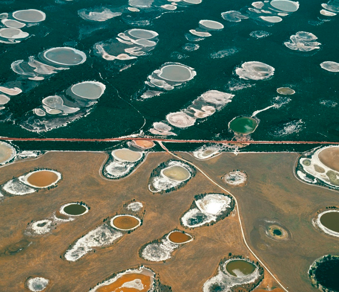
Islands on natural salt lake, Lake Johnston, north of Esperance, in Western Australia. (Taken 2014)
I have been attracted to the Australian landscape because of its size and subtle differences — a sense of wonderment, how it all came about, the evolution of the landscape. Like the rest of the world it has gone through many stages to be what it is today — uniquely Australian. But it also is a very old landscape. It is the flattest and driest continent, which compared with other countries, does not manifest itself in grandeur as we know it; large rivers, large mountains and the dramatic changes of the seasons.

The Pinnacles. Limestone formations, Nambung National Park. (Taken 2009)
However, I found that by looking at the landscape from the air, many natural characteristics revealed themselves much better, showing the evolution and the geographical variations. Nature is a great teacher. Observing and experiencing it can stimulate our creative senses which in turn is beneficial to ourselves and our environment.

Pink Lake, north-west of Esperance, Western Australia. This is the natural colouration of the salt lake. (Taken 1988)
It was in 1955 that I bought my first camera, and this was the beginning of a long association with photography. Intrigued by the unusualness of the Australian landscape, I became a landscape photographer with a strong bias for aerial photography, which I felt captured the vastness of the outback best — each flight became a flight of discovery.

Late light on a drifting sand dune, Windorah, south east Queensland. (Taken 1994)
There are so many Australian landscapes worthy of consideration whether they be rivers, coastal plains or deserts — all of which vary seasonally and at different times of the day. As much as possible I like to be inspired by what I see and this is where I experience a sense of wonderment of a world so complex, varied and beautiful.

Coastline between Esperance and Cape Arid, in Western Australia. This shows the reflection of the clouds in the lake, with the beach and ocean in the foreground. (Taken 2006)
Of course there are many ways to appreciate the landscape. My own involvement is to photograph the highlights and to interpret them with the camera in a painterly way. I emphasise these highlights by pointing the camera down and focussing on the subject, excluding the horizon so one looses a point of reference and the reality often takes on an abstract view. I hope that the character of the subject is enhanced and that it reveals more through isolation by the camera angle.

A turkey nest dam near Newdegate, Western Australia, contrasts against the ploughed fields. (Taken 1994)
The aerial point of view also allows us to examine the impact of humanity on Earth. There is a beauty in the man made landscape which takes on a relationship beyond the form as we know it. Certain subjects such as mining dumps, industry and farming look mundane at ground level, but from above my eye begins to recognise a gratifying order in the chaos — crops, paddocks and ploughed fields become masterpieces in abstraction often unknown to their creators. Simultaneously, the aerial perspective can also indicate the abuse and destruction that has taken place.
Salt lakes surrounded by wheat fields, 50 kilometers north east of Esperance, Western Australia. (Taken 1994)
At all times, I take a very personal approach to my work, but I also take great care to retain the optical reality. There are a million pictures out there. I am the only limitation. I can tune in and absorb the reality of the variations, combined with my way of seeing and my attitude. The older I get the harder it becomes, and the more I am drawn to nature. It is the creation of all life and matter that appeals to me now. Maybe I can make a small contribution to its well being which is in jeopardy. If beliefs in eternity are formed, nature is a great catalyst. I often feel intimidated by a great outback landscape, but also inspired by it.
Forrest River, Kimberley, Western Australia. A tidal river system, north-west of Wyndham. (Taken 2003)
We now have more technical gadgetry at our disposal and there is no doubt it can help us to get a better photograph. But that in itself means little unless it enhances our understanding of the world around us. It is more important to use our creative spirit and gain wisdom than purely use it as a tool. Today in our digital age we have Photoshop with its possibility to enhance or to completely distort or create our own image using photographic components. We have become so image conscious that we often forget the beauty of reality.

Ocean between Ningaloo Reef and Coral Bay, Western Australia. The blue variation is due to the ocean’s floor level. (Taken 2006)
The subject of photography can either be concrete or intangible. In the first case the picture is basically realistic, where as in the latter case it is essentially abstract. But what makes photography so interesting is that by combining both we can introduce creativity in the subject and have the best of both worlds.

Ant clearings approx. 4–5 metres across, Great Sandy Desert, Pilbara, Western Australia. (Taken 2003)
Although many photographers can take photographs and do it well, it is work done in the full utilization of that creative spirit that stands out. It should be influenced by the subject itself and come from within oneself.

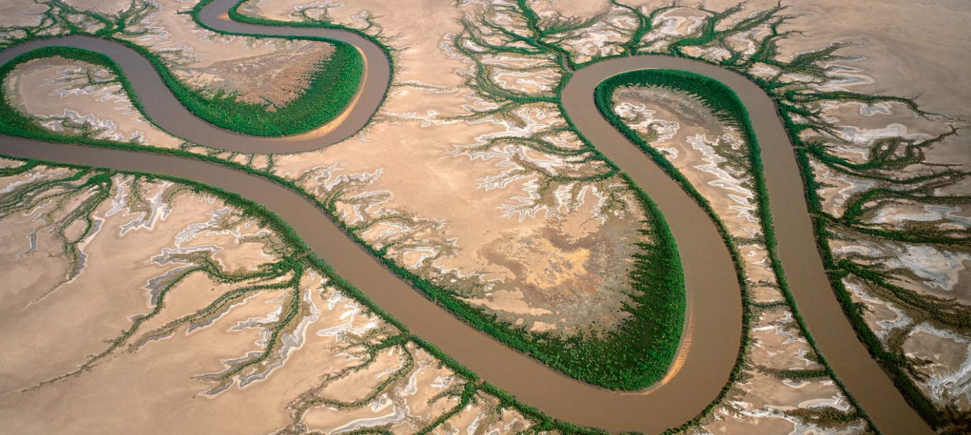
Tidal variations result in a coastal river pattern, Northern Territory. (Taken 2004)
“I still can’t find any better definition for the word Art, than this. Nature, Reality, Truth, but with a significance, a conception, and a character which the artist brings out in it and to which he gives expression, which he disentangles and makes free.” — VINCENT VAN GOUGH

Lake Dumbleyung, Wagin, Western Australia. Affected by farming this natural lake has become saline. After the first rains, it turns pink. (Taken 2005)
We do not always appreciate the aerial point of view. People regard the landscape as something you fly over. But in reality it is an opportunity to see the landscape from a different perspective. I never cease to marvel at the natural variations in the Australian landscape and although I value what is there photographically, in the end it is the observation and appreciation of the diversity that is the reward.

Top of Curtis Island, Cape Capricorn, north-east of Gladstone, Queensland. An estuary with sand banks. (Taken 1997)
Postscript — All of my photographs are as seen from the air and are not manipulated. I feel that the beauty, colours, and uniqueness of the Australian landscape is complete and needs no enhancing.
RICHARD WOLDENDORP is a Dutch-born Australian landscape photographer, with a focus on the aerial perspective. Appointed the Order of Australia in June 2012, “For service to the arts as an Australian landscape photographer.”
THIS ARTICLE WAS ORIGINALLY PUBLISHED ON MAPTIA

The Origins of Pama-Nyungan, Australia’s Largest Family of Aboriginal Languages
The approximately 400 languages of Aboriginal Australia can be grouped into 27 different families. To put that diversity in context, Europe has just four language families, Indo-European, Basque, Finno-Ugric and Semitic, with Indo-European encompassing such languages as English, Spanish, Russian and Hindi.
Australia’s largest language family is Pama-Nyungan. Before 1788 it covered 90% of the country and comprised about 300 languages. The territories on which Canberra (Ngunnawal), Perth (Noongar), Sydney (Daruk, Iyora), Brisbane (Turubal) and Melbourne (Woiwurrung) are built were all once owned by speakers of Pama-Nyungan languages.
All the languages from the Torres Strait to Bunbury, from the Pilbara to the Grampians, are descended from a single ancestor language that spread across the continent to all but the Kimberley and the Top End.
Where this language came from, how old it is, and how it spread, has been something of a puzzle. Our research, published today in Nature Ecology and Evolution, suggests the family arose just under 6,000 years ago around what is now the Queensland town of Burketown. Our findings suggest this language family spread across Australia as people moved in response to changing climate.
Aboriginal Australia is often described as “the world’s oldest living culture”, and public discussion often falsely assumes that this means unchanging. Our research adds further evidence to Australia pre-1788 being a dynamic place, where people moved and adapted to a changing land.

Map of Pama-Nyungan languages, coloured by their main groupings. Compiled by Claire Bowern using data from National Science Foundation grant BCS-0844550.
Tracing Pama-Nyungan
We used data from changes in several hundred words in different languages from the Pama-Nyungan family to build up a tree of languages, using a computer model adapted from those used originally to trace virus outbreaks.

Different related words for ‘fire’ in certain Pama-Nyungan languages. Green dots show languages with a word for ‘fire’ related to *warlu; white has *puri; red has *wiyn; blue has *maka, and purple *karla. Chirila files (http://chirila.yale.edu) and google earth for base image.
Because our models make estimates of the time that it takes for words to change, as well as how words in Pama-Nyungan languages are related to one another, we can use those changes to estimate the age of the family.
We found clear support for the origin of Pama-Nyungan just under 6,000 years ago in an area around what is now the Queensland town of Burketown. We found no support for the theories that Pama-Nyungan spread earlier.
The timing of this expansion is consistent with a theory that increasingly unstable conditions caused groups of people to fragment and spread. But correlation is not causation: just because two patterns appear related, it does not mean that one caused the other.
In this case, however, we have other evidence that access to ecological resources has shaped how people migrated. We found that, in our model, groups of people moved more slowly near the coast and major waterways, and faster across deserts. This implies that populations increase where food and water are plentiful, and then spread out and fissure when resources are harder to obtain.
You can see a simulated expansion here. The spread of Pama-Nyungan languages mirrored this spread of people.
What languages tell us
Languages today tell us a lot about our past. Because languages change regularly, we can use information in them to work out who groups were talking to in the past, where they lived, who they are related to, and where they’ve moved. We can do this even in the absence of a written record and of archaeological materials.
For places like Australia, the linguistic record, though incomplete, has more even coverage across the continent than the archaeological record does. At European settlement, there were about 300 Pama-Nyungan languages. Because there are at least some records of most of them we are able to work with these to uncover these complex patterns of change.
There are approximately 145 Aboriginal languages with speakers today, including languages from outside the Pama-Nyungan family. Many of these languages, such as Dieri, Ngalia and Mangala, are spoken by only a few people, many of whom are elderly.
Other languages, however, are actively used in their communities and are learned as first languages by young children. These include the Yolŋu languages of Arnhem Land and Arrernte in Central Australia. Yet others (such as Kaurna around Adelaide) are undergoing a renaissance, gaining speakers within their communities.
Nathan B. performing “Yolŋu Land” using English and Yolŋu Matha.
Finally, though not the focus of our study, there are also new languages, such as Kriol spoken across Northern Australia, Palawa Kani in Tasmania, and Gurindji Kriol. Many Aboriginal and Torres Strait Islanders also know English, and most Indigenous Australians are multilingual.
Without records of all these languages, and without ongoing work to support speakers and communities, we aren’t able to do research like this, and Australia loses a vital link to its history. After all, European settlement of Australia is a tiny chunk of the time people have lived on this land.
This article was originally published on The Conversation.
CLAIRE BOWERN
Claire Bowern is Professor of Linguistics at Yale University. Her 2004 PhD is from Harvard University and examined the historical morphology of complex verb constructions in a family of non-Pama-Nyungan (Australian) languages. Her research focuses on the Indigenous languages of Australia, and is concerned with language documentation/description and prehistory.
Warm Waters
WARM WATERS is a long-term photographic project investigating the impacts of climate change on the vulnerable communities and environments throughout the Pacific Region. From rising sea levels and the effects of increasingly extreme weather effects, such as El Niño and super typhoons, to floods and droughts, the destruction of coast, and the first climate refugees — I am collecting visual evidence of what is happening on the front lines of man-made global warming today, and how these phenomena are being dealt with.

ABOVE: Residents of the South Tarawa Atoll in Kiribati, bathing in the lagoon near the town of Bairiki. Seawalls protect the tiny islets of the atoll from the rising sea levels, however, many of them are constantly destroyed by high tides. (South Tarawa, Kiribati)

ABOVE: Dead coconut trees on the atoll of Abaiang, in an area of land where soils have become increasingly eroded and salinated by the regular flooding that occurs during high tides. Abaiang is one of Kiribati’s most threatened threatened islands. The government says this area is a “barometer for what Kiribati can expect in the future.” Since the 1970s the residents of Tebunginako have seen the sea levels rise and today a major part of the village has had to be abandoned. (Tebunginako, Kiribati)
Since 2013 I have travelled across most of the countries in Oceania — covering sea level rise in Tuvalu, Kiribati, Tokelau and the Marshall Islands, land grabs and related climate change issues in Papua New Guinea, super cyclones in Vanuatu, Tuvalu and Fiji, and climate change related migrations in Solomon Islands. One of the biggest issues facing mankind today, I aim to document climate change through the prism of communities whose very existence is threatened. Warm Waters shows that global warming is not a distant reality for future generations, but a critical issue for which we must all take collective responsibility and immediate action.

ABOVE: A plastic barrel of drinking water is hoisted up in the coastal village of Hanuabada in Papua New Guinea. With climate change, tides here are rising, exacerbating already severe sanitation issues. During high tide events, human waste flows freely between water resources, water-borne diseases like diarrhoea, dysentery, and typhoid start spreading, and potable water becomes scarce. (Hanuabada village, Port Moresby, Papua New Guinea)

ABOVE: Children in front of the Kiribati Parliament House in South Tarawa. Kiribati is one of the four atoll nations that are located in the Pacific Ocean. Most of Kiribati’s atolls rise no more than a couple of metres above sea level, and are very vulnerable to rising seas. (South Tarawa, Kiribati)
2015 was the warmest year on record and sea temperatures are increasing. Responsible for many of the climate conditions in the Pacific, El Niño weather patterns are intensifying. From Category 5 Cyclone Pam in South Pacific, to ice melting beneath First Nations’ feet — storms, droughts, floods, and heatwaves are becoming more severe and frequent.
The ramifications of shifting weather conditions are extremely complex. Physical environmental changes are implicating culture, history and tradition. Rising sea levels and erosion are shrinking already tiny land masses and changes to ecosystems are affecting food resources and tourism. As quickly as communities build sea walls, they are destroyed by storm surges. As people rebuild homes and schools after a cyclone, they are damaged by another. Rising temperatures are fracturing once solid ice and cracks are appearing in otherwise strong communities. People need move inland, and in the most extreme cases, relocate entirely.
“They are not escaping war or persecution, they are fleeing their own environment. They are the world’s first climate change refugees.”

ABOVE: An aerial view of Majuro, the capital of the Marshall Islands. The Marshall Islands comprises two chains of coral atolls, together with more than 1,000 islets. It is on average just two meters above sea level. The country faces an existential threat from rising sea levels with some predictions claiming that the islands will be swamped by the end of the 21st century. (Majuro, Marshall Islands)

ABOVE: A collapsed house on the banks of Mataniko River in Honiara, the capital of the Solomon Islands. In 2014 the region was badly affected by flash floods, which took the lives of 22 people and left 9,000 homeless. Thousands of homes located on Mataniko’s banks were washed away and many gardens were destroyed. (Honiara, Solomon Islands)
The longer the locals on these submerging islands search for solutions, the more their landmass is decreasing. While discussions elsewhere in the world still revolve primarily around the causes of climate change, the lives of those living in the Pacific revolve around adaptation and survival. Carbon dioxide emissions continue to accumulate in the atmosphere and these communities, some of the world’s most vulnerable, are already experiencing the reality of one of the greatest challenges facing humanity.

ABOVE: A father and son building a sea wall in front of their house in Fale village, Fakaofo Atoll, Tokelau. About 350 people live on this islet, which has a height of no than two metres above the high water mark during ordinary tides. In an attempt to fight the rising sea levels, Fale residents have enclosed their islet in concrete, with 5 to 7 metres high sea walls, hoping to protect their homes from storm surges. (Fakaofo Atoll, Tokelau)

ABOVE: Children playing in the water near a seawall in Tebikenikoora village, one of the islands most affected by sea level rise area in Kiribati. The village is regularly flooded during high tides despite residents attempts to build sea walls or take care of those that were built by the local government, but frequent big waves continue to damage them, putting resident’s houses, and gardens, under constant threat. (South Tarawa, Kiribati)
In 2014 and 2016, I visited Kiribati and the Marshall Islands — small, submerging island states that are starting to disappear because of rising sea levels and the extreme power of super typhoons, which fall on them far more often than in previous decades. Scientists say that they will be unsuitable for habitation by the end of the century. These countries are located on coral atolls, pieces of land in the middle of the vast ocean, which are only several dozen meters wide in their narrowest parts.
During high tides and severe storms, huge waves flood the roads, and seawater gets into the houses, also destroying gardens and vegetable patches. In some parts of Kiribati, whole villages have had to move inside the island because of coastal erosion.
“People live in constant fear that their homes will be destroyed, and their small children washed into the ocean, so during bad weather some parents tie up their children to heavy objects inside the house.”

ABOVE: Children playing on a sea wall in the town of Betio, near the rusting remains of a wrecked ship that was lifted and smashed onto the wall during a king tide in February 2015. (Betio, South Tarawa, Kiribati)

ABOVE: Jorlang Jorlang, 70, lies on his bed while his wife Tita finishes hanging laundry. In April 2014 a ‘king tide’ hit their house in Jenrok village on the Marshall Islands, and the seawater came inside. The rest of the family evacuated the house, but Jorlang couldn’t move, due to his disability. His wife had to stay with him for two days and wait until the water was gone. (Jenrok, Marshall Islands)
In Majuro, the capital of the Marshall Islands, I visited a cemetery where the graves are gradually submerging. For me, this one of the most convincing arguments for those who deny the effects of climate change and global warming , because why would anyone build cemeteries within reach of the tide on purpose? Several decades ago the locals would never have thought that the bones of their ancestors would be underwater.

ABOVE: A graveyard in Jernok village that is slowly being destroyed by the rising seas, in the Marshall Islands’ capital Majuro. “Cemeteries along the coastline are being affected,” says Kaminga Kaminga, a climate change negotiator for the Marshall Islands. “Gravesites are falling into the sea. Even in death we’re affected.” In June 2014, rising sea levels washed out the remains of 26 Japanese WWII soldiers on Santo Island. (Jernok, Marshall Islands)

ABOVE: Children playing ‘hide and seek’ in Teone’s graveyard in Funafuti, the capital of Tuvalu. Massive coastal erosion in Teone caused many coconut trees fall down, and the sea eaten its way into and around the trees that are still standing. People from Teone are threatened on one side by the ocean and its tide surges and on the other by a pit that fills with salt water at high tide due the soil salinisation. (Teone, Funafuti, Tuvalu)
I also visited the Polynesian island nation of Niue, which has land much higher above sea level. Already, some of the inhabitants of Tuvalu, another Oceanic state that is gradually submerging, have been relocated to Niue. In recent years, many of the locals from Niue have been emigrating to New Zealand in search of work, so the authorities decided to give Tuvaluan people a home to populate again partly abandoned villages.

ABOVE: Hetu, 8, holds a shark that was caught by fishermen in Fakaofo Atoll, Tokelau. Tokelau is a small atoll nation of Polynesia, which is a self-administering territory of New Zealand. Access to Tokelau is possible only by ferry from Samoa, and boats usually depart every two weeks from Samoan capital Apia. Isolation, lack of job opportunities, and vulnerability to climate change has the forced majority of Tokelauans to leave their homes in search of a better life in New Zealand or Australia. (Fakaofo Atoll, Tokelau)

ABOVE: Children of Etas village on Efate Island watch a water truck delivering drinking water to their village. After Cyclone Pam hit Vanuatu on 13 March 2015, many local communities were left without fresh water supplies. International charity Oxfam organised an airport water tank truck to come to the villages around Port Vila and help locals to fill their barrels with drinking water. Over 15 people died in the storm and winds up to 165 mph (270 km/h) caused widespread damage to houses and infrastructure. Cyclone Pam is considered one of the worst natural disasters ever to affect the country. (Etas, Efate Island, Vanuatu)
In 2015 after spending time capturing the aftermath of the destructive Cyclone Pam on Vanuatu, I travelled to Tuvalu on a UNICEF commission. I was lucky to find myself on the same ship as the official delegation, headed by Tuvalu prime minister Enele Sopoaga, and including almost all ministers. The ship went to the most remote islands of Nui, Vaitupu and Nukufetau, all severely damaged by Cyclone Pam. I was the only professional photographer there to capture the aftermath of the cyclone.
Before our arrival the huge waves had eroded the cemetery on Nui, and there were bones and half-decomposed bodies floating all over the island. The pigs and chickens had started to eat them, and so the Tuvaluan government sent instructions that all of the animals must be killed to prevent disease spreading. For the locals, whose livelihood is based on fishing and animal husbandry, it was, of course, a tragedy.

ABOVE: People from Nukufetau Atoll boarding the ‘Manu Folau’, a ship that will take them to Funafuti, the capital of Tuvalu, where they hope to take refuge. Nukufetau was among the other outer islands of Tuvalu that were badly hit by Cyclone Pam in March 2015. Many residents left the damaged areas and went to to stay with relatives in Funafuti, which was not affected by the cyclone. (Nukufetau Atoll, Tuvalu)

ABOVE: Nelly Seniola, 35, extension officer in the Tuvaluan fisheries department, shows a photograph on his laptop of a corpse that was washed out of a cemetery by a storm surge. Nelly told me, “There were many dead bodies, skulls and bones floating around. Pigs and chickens started to eat some of the bodies. We received a radio message from the capital, that we had to kill those animals, as they could spread diseases.” (Tuvalu)

ABOVE: A house on stilts, built over a polluted ‘borrow pit’ on the edge of Funafuti, in Tuvalu. The settlement, called Eton, is threatened on one side by the ocean’s waters and tide surges and, on the other, by stagnant saltwater filled ‘borrow pits,’ where sand and rocks were excavated by the American military during WW2 in order to build a runway. The pits are a dump for the refuse that is increasingly clogging the islands and a health hazard for those living alongside. (Funafuti, Tuvalu)
Towards the end of 2015 I made a one-month trip around the islands in northern part of Oceania, including Guam, the Northern Mariana Islands, and the Federated States of Micronesia and Palau. In addition to documenting the effects of coral bleaching and sea level rise, I was also capturing the aftermath of super typhoon Maysak, the most powerful pre-April tropical cyclone on record in the Northwestern Pacific Ocean.
Maysak affected Yap and Chuuk states in the Federated States of Micronesia, with damage estimated at $8.5 million (2015 USD). The Red Cross reported there were as many as 5,000 people in desperate need of food, water, and shelter, and who required emergency assistance.

ABOVE: Roxanna Miller, monitoring technician of the University of Guam Marine Lab, inspecting species of staghorn corals severely impacted by coral bleaching event in 2013–2014. The bleaching resulted in loss of about half of all Guam’s staghorn corals. Although the remaining corals are slowly recovering, because of the increasing effects of global warming they can be hit again by rising water temperatures and extreme low tide events. Loss of the coral reefs would directly impact on local fishermen, as the habitats the corals provide to reef flat fish communities, would be gone. (Guam)

ABOVE: A small islet in the Ulithi Atoll. With only a few palm trees remaining, it is almost entirely submerged during high tides. (Ulithi Atoll, Yap State, Federated States of Micronesia)
Most recently, I spent time in Fiji, Samoa, Tokelau, and the Solomon Islands. On the 20 and 21 February 2016 Category 5 Severe Tropical Cyclone Winston hit Fiji, destroying the country’s infrastructure and thousands of homes. At the time of my visit, 43 people had been confirmed dead and more then 60 thousand had been forced to flee, living in evacuation centres hurriedly set up across the country.

ABOVE: The southern part of Taveuni Island in Fiji is among the areas most affected by Cyclone Winston. Some villages were completely destroyed and people were left without food for about a week, as access to the island was cut off. (Taveuni Island, Fiji)

ABOVE: Locals prepare food rations, given by private donors, for delivery to affected villages of southern part of Taveuni Island in Fiji, one of the most affected areas. (Taveuni Island, Fiji)
As global warming continues, many countries in the Pacific region will feel the effects of the destabilization of the planet’s ecosystem. Extreme weather events, such as unusually high temperatures and cyclones are already devastating small island nations. I have decided to dedicate several years to the Warm Waters project, and have plans to travel around the whole Pacific region from Alaska to New Zealand, documenting the unpredictable and severe effects of climate change.

ABOVE: Teiwaki Teteki, 28, carries his 4-year-old son Paaia to the shore in heavy rain. Teiwaki and other passengers travelled to Taborio village from North Tarawa by “te wa uowa” (double) canoe, which is the only way to get from north of the Tarawa Atoll to the south during high tide. For nearly two years, it has been raining almost every day in the northern part of the Gilbert Islands chain. In 2015, the annual rainfall was 4 times higher than the average. (South Tarawa, Kiribati)
And yet, despite the painful and challenging situations I have witnessed, this project is as much about resilience as it is about tragedy. Local and international organizations are helping to introduce renewable energy, new water tanks, and fortified roads into these communities. People are being relocated following, and in case of, the ever-increasing likelihood of natural disasters related to global warming. And in the children, I see hope. When it floods, they swim in the pools of water near their houses, or try to surf on improvised surf-boards during high tides.
“Many communities in the Pacific are optimistic and resilient, determined to find solutions rather than be case studies of climate change victims.”

ABOVE: A young girl playing in the remains of an oil barrel near the shore of Tebunginako village in Kiribati. The island nation is slowly being swallowed by rising sea levels, and will likely be uninhabitable before the end of the century. (Tebunginako, Abaiang Atoll, Kiribati)
—
Some photos from this gallery were taken on assignments for UNICEF Pacific and Oxfam Australia
THIS ARTICLE WAS ORIGINALLY PUBLISHED ON MAPTIA.
VLAD SOKHIN
Documentary photographer, multimedia producer and film-maker, represented by Panos Pictures. Author of the book, ‘Crying Meri’.
Into the Outback
An epic and ancient landscape, deeply entwined with the artistic, musical, and spiritual traditions of Indigenous Australians, the Outback is one of the largest remaining, intact natural areas on Earth. A cultural, ecological, and geological wonder, I explore and capture these vibrant regions on foot and from the air.

Known for its Aboriginal peoples and its vast, ancient landscapes, the Outback is an incredibly special place for me. I think that once you get that distinctive red dust in your blood it never comes out.
My roots are deeply connected to the rural areas of western Queensland and from a very young age, the never-ending expanse of inland Australia has been something that has captivated me. Ever since I can remember, we would take long road trips out to a family-run cattle station, and there was always this great sense of wonder and adventure. In the Outback, you can travel for days in any direction and stumble across places that are unique, untouched, and rarely visited. It was on these early trips that I fell in love with the bush, the people, and its landscape. I’ve never stopped venturing back.

Pannawonica Hill, near the small town of Pannawonica, a tiny iron-ore mining settlement in the Pilbara region of Western Australia. // © Dan Proud
Drawn to remote, wide open spaces, to the dusty and the desolate, I have found that there are countless unique rocky outcrops and ridges to explore. From the arid and ancient regions of Kimberly and Pilbara in Western Australia, to the rugged, weathered peaks and dramatic rocky gorges found in the Flinders Ranges of South Australia, to the red centre and Australia’s most famous monolith, Uluru — it is not only the sheer size of the Outback that is astounding (it could encompass almost all of Europe), it is also home to some of the world’s most spectacular and untouched landscapes. Over the past few years, I’ve been lucky enough to photograph, film, and fly over these regions — both in light aircraft, and more recently, with drones.

The West MacDonnell Ranges, known as the West Macs, seen from the air. Found in Australia’s Red Centre, west of Alice Springs. // © Dan Proud
Deeply entwined with the landscape itself are the artistic, musical, and spiritual traditions of the Indigenous Australians, among the longest surviving cultural traditions in human history. Some 30,000 to 70,000 years ago — many millennia before the European colonisation that would come to threaten and profoundly disrupt many Aboriginal communities — the first inhabitants of Australia arrived from the north, making them amongst the world’s earlier mariners. They spread throughout the landmass, surviving even the harsh climatic conditions of the Last Glacial Maximum.
Evidence of ancient Aboriginal art is found all over the Outback, most notably at Uluru and Kakadu National Park in the Northern Territory. An impressive sandstone rock formation, Uluṟu — as it called by the Pitjantjatjara Anangu, the Aboriginal people of the area — or Ayers Rock, still holds great sacred and cultural significance for the local indigenous population. Appearing to change color at different times of year, this natural monolith is quite magnificent as it glows a deep red or purple at sunrise and sunset.

Uluru, or Ayers Rock, the huge sandstone monolith in Australia’s Red Centre, glows deep red at sunset. // © Dan Proud
It was only in 1606, little over four centuries ago, that the first known European landing was made by Dutch navigator Willem Janszoon on the western shore of Cape York, in Queensland. This discovery was closely followed by that of Dirk Hartog, another Dutch explorer, who sailed off course during a voyage in 1616 and landed on what is now known as Cape Inscription, thus discovering the coast of Western Australia.
For many decades to come, the true extent of the continent would not be known, and with the exception of further Dutch visits to the west, Australia remained largely unvisited. Although a number of shipwrecks are evidence that other Dutch and British navigators did encounter the coast during the 17th century, usually unintentionally, it would be over 150 years before the crew of HMS Endeavour, under the command of British explorer Lieutenant James Cook, sighted the east coast of Australia in 1770 and Europeans widely came to believe that the great, fabled southern continent existed.

Trees in stark contrast with the vibrant orange of Uluru, or Ayers Rock. // © Dan Proud
Running in parallel ridges to the east and west of Alice Springs, through Australia’s Red Centre, lie the East and West MacDonnell Ranges, also known as the Macs. Most people imagine the Outback to be completely flat, but these mountains run for more than 600 kilometres and in places reach heights of over 1,500 metres. Formed 300 to 350 million years ago, folding, faulting, and erosion have since shaped the Macs to form numerous narrow gaps and gorges, and they contain many areas of cultural significance. Seen from the air, their undulating and intricate rock formations are spectacular.

The West MacDonnell Ranges seen from the air, in Australia’s Red Centre, west of Alice Springs. // © Dan Proud
Weather patterns in the Outback are also something that surprises many people. While often envisaged as a uniformly arid area, the Outback regions stretch from the northern to southern Australian coastlines, and encompass a number of climatic zones — including tropical and monsoonal climates in northern areas and temperate climates in the southerly regions. At times, dramatic dust and thunder storms roll in, soaking the dry ground and often causing flash flooding. Witnessing these storms is an incredible experience.

Dust and thunder storm meet near the tiny settlement of Innamincka, Southern Australia. Situated on the banks of Cooper Creek, it is surrounded by the Strzelecki, Tirari and Sturt Stony Deserts. // © Dan Proud
Reflecting its wide climatic and geological variation, the Outback contains a number of distinctive and ecologically-rich ecosystems, along with many well-adapted animals, such as the red kangaroo, the emu, and the dingo, which are often to be found hidden in the bushes to keep cool during the heat of the day. Recognised as one of the largest remaining, intact natural areas on Earth, the Outback is home to many important endemic species.
One such species is Adansonia gregorii, known locally as the boab tree, which is found nowhere else in the world but the Kimberley region of Western Australia, and east into the Northern Territory. With their striking swollen trunks, boab trees can reach up to five metres in diameter at their base, and amazingly, some individual trees are more than 1,500 years old, making them the oldest living beings in Australia, and among the oldest in the world.
For thousands of years, Indigenous Australians have used these giants for shelter, food and medicine; often collecting water from hollows within the tree, and using the white powder that fills the seed pods as food. Decorative paintings or carvings were also made on the outer surface of the fruit.

A boab tree growing in the Kimberly region of Western Australia. // © Dan Proud
Also found in the Kimberly region is the Cockburn Range, a magnificent sandstone escarpment that rises for 600 metres above the surrounding plains. Shaped like a vast fortress with towering orange cliffs, many rivers have cut through the formation to form steep-sided gorges. Flying above the Range at sunset, when the western face is lit up with a brilliant red glow, reveals another of the Outback’s epic and ancient landscapes.

Sunset flight over the Cockburn Ranges in Kimberley, Western Australia. // © Dan Proud
The geology of South Australia’s Outback is no less dramatic, and among the rugged, weathered peaks and rocky gorges of the Flinders Ranges, some of the oldest fossil evidence of animal life was discovered in 1946, in the Ediacara Hills. Similar fossils have been found in the Ranges since, but their locations are kept a closely guarded secret to protect these unique sites.
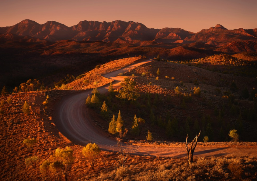
Cast in golden light, Bunyeroo Valley in Southern Australia. // © Dan Proud
The first humans to inhabit the Flinders Ranges were the Adnyamathanha people — meaning “hill people” or “rock people” — whose descendants still reside in the area, and also the Ndajurri people, who no longer exist. Cave paintings and rock engravings tell us that the Adnyamathanha have lived in this region for tens of thousands of years. Though my perspective is usually broad and from the air, in the nooks and crannies of these arid landscapes live the yellow-footed rock-wallaby, which neared extinction after the arrival of Europeans due to hunting and predation by foxes, and also two of the world’s smallest marsupials — the endangered dunnart, and the nocturnal, secretive planigale, smallest of all, often weighing less then five grams.

The dramatic Flinders Ranges of Southern Australia seen from above, photographed by drone. // © Dan Proud
Last but certainly not least, we come to the spectacular Pilbara region of Western Australia. Stretching over a vast area of more than 500,000 square kilometres in the north of Western Australia, it is home to some of Earth’s oldest rock formations, dating back an impressive two billion years.
Seen from the air, parts of the Pilbara can sometimes resemble another planet. Yet the greens and yellows of the acacia trees, the hardy shrubs, and the drought-resistant Triodia spinifex grasses — contrasting so spectacularly with the brilliant orange and ochre of the land itself — remind us that life can flourish and adapt even in the most challenging of conditions.

The vibrant colors and unusual contours of the mineral-rich Pilbara landscape in Western Australia. // © Dan Proud
Known also for its vast mineral deposits, for many years the Pilbara has been a mining powerhouse for crude oil, natural gas, salt, and iron ore. Today, although the fragile ecosystems of this area have been damaged by these extractive industries, a number of Aboriginal and environmentally sensitive areas now have protected status in the Pilbara — including the stark and beautiful Karijini National Park with its deep gorges and striking canyons.

Stunning displays of rock layers at Hancock Gorge in the Pilbara. // © Dan Proud
Culturally, Australia’s Outback regions will always be deeply ingrained in our country’s heritage, history, and folklore. For Indigenous Australians, creation of the land itself is believed to be the work of heroic ancestral figures who traveled across a formless expanse, creating sacred sites on their travels. Ecologically, it is one of the most untouched and intact natural areas we have left on the planet, and home to a plethora of important endemic species. Geologically, it represents a vast and ancient landscape — one of the most unique on Earth and one that I could never tire of exploring. Every time I head up into the air or set out to photograph the Outback, I’m blown away.

Dotted with acacia trees, the striking landscape of Pilbara’s Outback region at dusk. // © Dan Proud
THIS ARTICLE WAS ORIGINALLY PUBLISHED ON MAPTIA.
DAN PROUD
Dan Proud is a Queensland-based photographer and film maker with a passion for aerial cinematography and capturing the magical wide open spaces of Australia.
Explore Aotearoa with Ludovic Gilbert
Aotearoa is the Maori name for New Zealand. Ludovic Gilbert and his wife spent 3 weeks there for their honeymoon, and traveled more than 4,000 miles through Christchurch, Akaroa, Lake Tekapo, Te Anau, Wanaka, Fox Glacier, Punakaiki, Kaiteriteri, Wellington, Tongariro, Taupo, Whengamata and Auckland. Here are the fantastic landscapes, beautiful people and lakes with amazing colors they found.
VIDEO: Scuba Diving in the Heart of Yap
Julie Hartup, part of Manta Trust, a non-profit organization, recently went to Yap to begin a long-term monitoring and research program. This footage was complied over four days of scuba diving at a shallow cleaning station with help from the Manta Ray Bay Resort.