Bear Dance

One of my most vivid memories growing up as young child in Romania is watching loud, drunken bears dancing wildly around my grandparents’ living room. Electrifying, enchanting, and at times also quite scary, the annual “bear dance” was always one of the highlights of our holiday season, especially given the strict era of Communist rule.

Every year, in a handful of towns and villages along the Trotus Valley of Romania, troupes of “dancing bears” — men and women of all ages wearing real bear skins — tour villages and visit people’s homes between Christmas and the start of January. This traditional folk ritual, where raucous packs of bears dance and play music for tips, liquor, and cubes of pig fat, is believed to chase away bad spirits from the previous year.

A troupe of bears performs in central Comăneşti during its annual Bear Parade and competition. The mayor organizes the event and offers a cash prize to the best bear troupe. Comănești, Bacău, Romania

When I was only eight years old, my family left Romania behind, and we became political refugees in Yugoslavia. After initially resettling in Canada, we then moved to New York when I was 16. I later went on to study Economics, Neuroscience, and International Development, and eventually returned overseas when I took up a career in humanitarian aid, often working with displaced populations, much like my family and I once were.

In 2013, I decided quit aid work and fully pursue a career as a photographer. I continued to spend most of my time in areas experiencing social unrest or humanitarian emergencies, but now I had a camera in hand. Last year, however, I took a week to return to Romania and visit my ailing grandmother — and to see the dancing bears again.

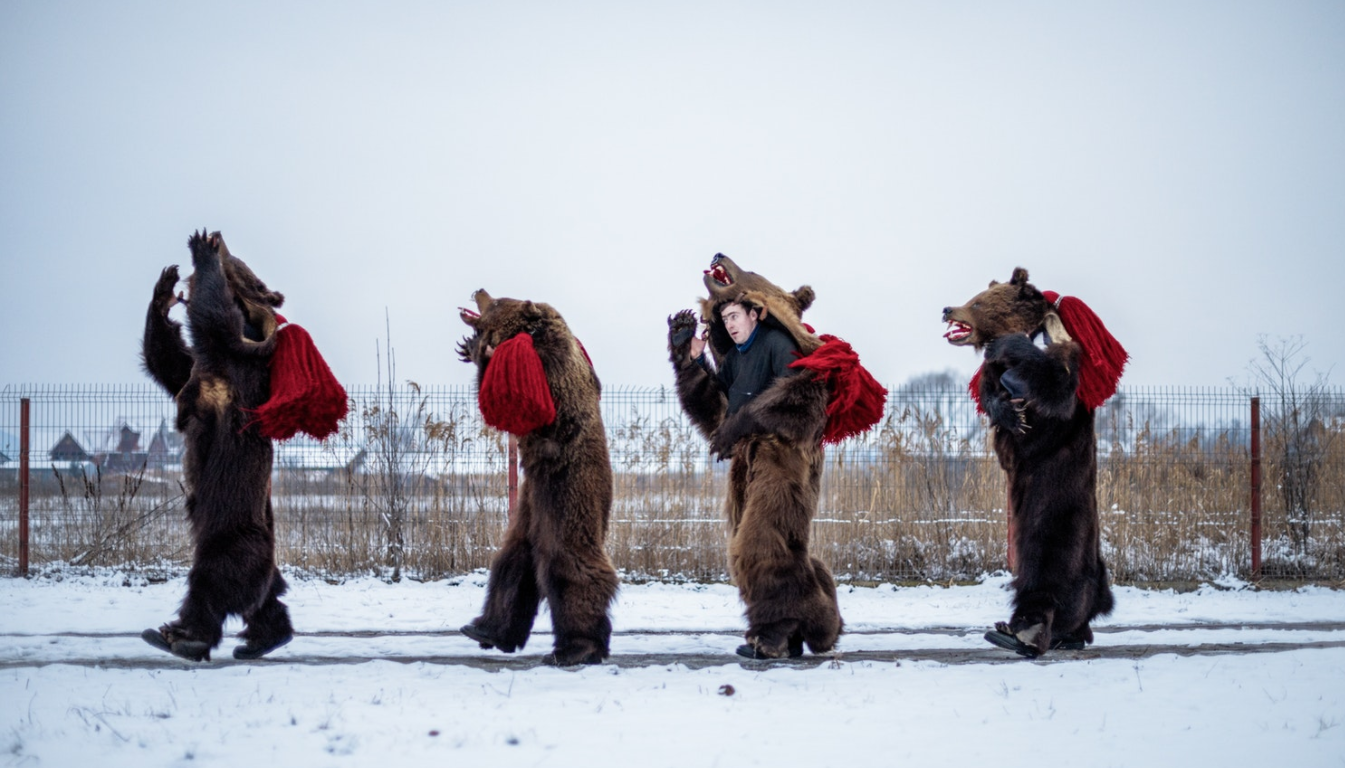
A troupe of bears dance through Comăneşti, stopping at homes where they have been invited to perform. Comănești, Bacău, Romania

My mother’s childhood friends introduced me to Dumitru Toloaca and his troupe of men, women and children clad in bearskins. I spent a few freezing days photographing them as they performed in the main square of Comăneşti, and then danced their way into the night, through villages like Asău, on their way to private homes where they had been invited to perform.

It’s not unusual for roads to be blocked by bear troupes towards the end of the year.

Cătălin Apetroaie chats with a young bear and the ‘bear tamer’ seated on his porch. He and the rest of Toloacă’s troupe have just finished performing for Apetroaie’s family.

There were so many times that I wanted to put my camera down, put on a bearskin, and join them. It was magical, like going into a fairy tale.

At first, you can’t see much because it’s so dark. You just hear the crunch of the bear-claw boots on the snow and then, all of a sudden, drumbeats break out and you hear the sound of flutes echoing through the alleyways. Then the dancers pass under a streetlamp, and you see bears caught in a snowstorm!

Toloaca’s troupe of bears dance through the night, making their way to the homes where they’ve been invited to perform. Asău, Bacău, Romania

As a child I remember how beautiful it was to wake up filled with anticipation on a snowy December morning and to hear drumbeats and chanting echoing through the valley. The bear troupes would come door to door and everyone would let them in. They were quite rambunctious, swinging their heads around and causing a mess as the snow on them melted.

Catalin Apetroaie, a bear in Toalaca’s troupe, serves his fellow bears a refueling of pig fat at his home in Laloaia where they have just performed. His wife fills up glasses of homemade palinka liquor.

The origins of Romania’s bear dance date back to the 1930s when the Roma, or gypsies, would descend from the surrounding mountains with bear cubs on leashes, and visit the homes of villagers. My grandmother still recalls how gypsies would be given a tip in exchange for the bear cub walking on the backs of the villagers, said to alleviate back pain.

Once a bear aged, the Roma would then employ it for a different purpose when visiting households — they would set the bear to walk on hot metal sheets, which would cause the bear to “dance” or skitter about on the metal to avoid the burning sensation beneath its feet.

Between visits to houses where they have been invited to perform, Toloaca’s troupe of bears stops at a bar for some rest, drinks and more celebrating. Asău, Bacău, Romania

No one really knows when the Roma began wearing bear skins and imitating their dancing bears, or when ethnic Romanians then adapted the ritual, but the gypsy origins are still clearly discernible in the lyrics sang by the “bear tamer” as well as the more traditional costumes sometimes worn, often complete with black stove grease or soot smeared onto the tamer’s face, to imitate the darker skin of a gypsy.

A troupe of bears performs down the main street in Moinesti, during the town’s annual bear parade. Moinești, Bacău, Romania

Today, the Roma are largely excluded from the tradition of bear dancing. Reasons include widespread discrimination against the Roma, as well as the increased cost of bear skins — as bear hunting in Romania has been strictly regulated for some time now, one skin can fetch up to 2,000 Euros.

A lady bear in Toloaca’s troupe plays with the young son of Catalin Apetroaie, a bear dancer himself, after a performance at his home. The child’s grandmother scurries by while his great-grandmother peers at the bears from inside the house. Asău, Bacău, Romania

In today’s post-communist era, modernization and westernization have created a new generation of youth more interested in video games than folk traditions . Moreover, most young adults move to nearby countries or larger cities, in search of work, leaving the rural areas populated by only the elderly or very young. It’s difficult to find people that will carry on the tradition. Coupled with the increasing financial struggles of rural households — after the the fall of communism, rural areas became poorer while urban ones became wealthier — the bear dance tradition is now at risk of disappearing.

A troupe of bears from Asău village performs in central Comăneşti during the town’s annual Bear Parade and Competition.

Although in the minority, female bears can be found in nearly every troupe. Comănești, Bacău, Romania

So far, Romania’s bear dance has survived largely due to the efforts of local governments who throw parades and competitions to incentivize the organization of bear troupes, as well as to recognize and celebrate the individual efforts of dedicated and passionate troupe leaders like Dumitru Toloaca. Like most of the other troupe leaders in the area, Toloaca grew up with the tradition as a boy and holds it close to his heart.

Dumitru Toloaca embraces his daughter, Roxana, as his troupe dances to the beat of the drummers and the lyrics of his bear tamer. Roxana, an only child, is his only hope for his bear troupe to carry on into the next generation. Asău, Bacău, Romania

About a year ago, at the urging of concerned local governments, UNESCO initiated a process that may result in Romania’s bear dance being included on its official “List of Intangible Cultural Heritage in Need of Urgent Safeguarding,” an international measure for the protection of cultural practices that are in danger of disappearing. This process takes at least two years to complete, and acceptance is not guaranteed.

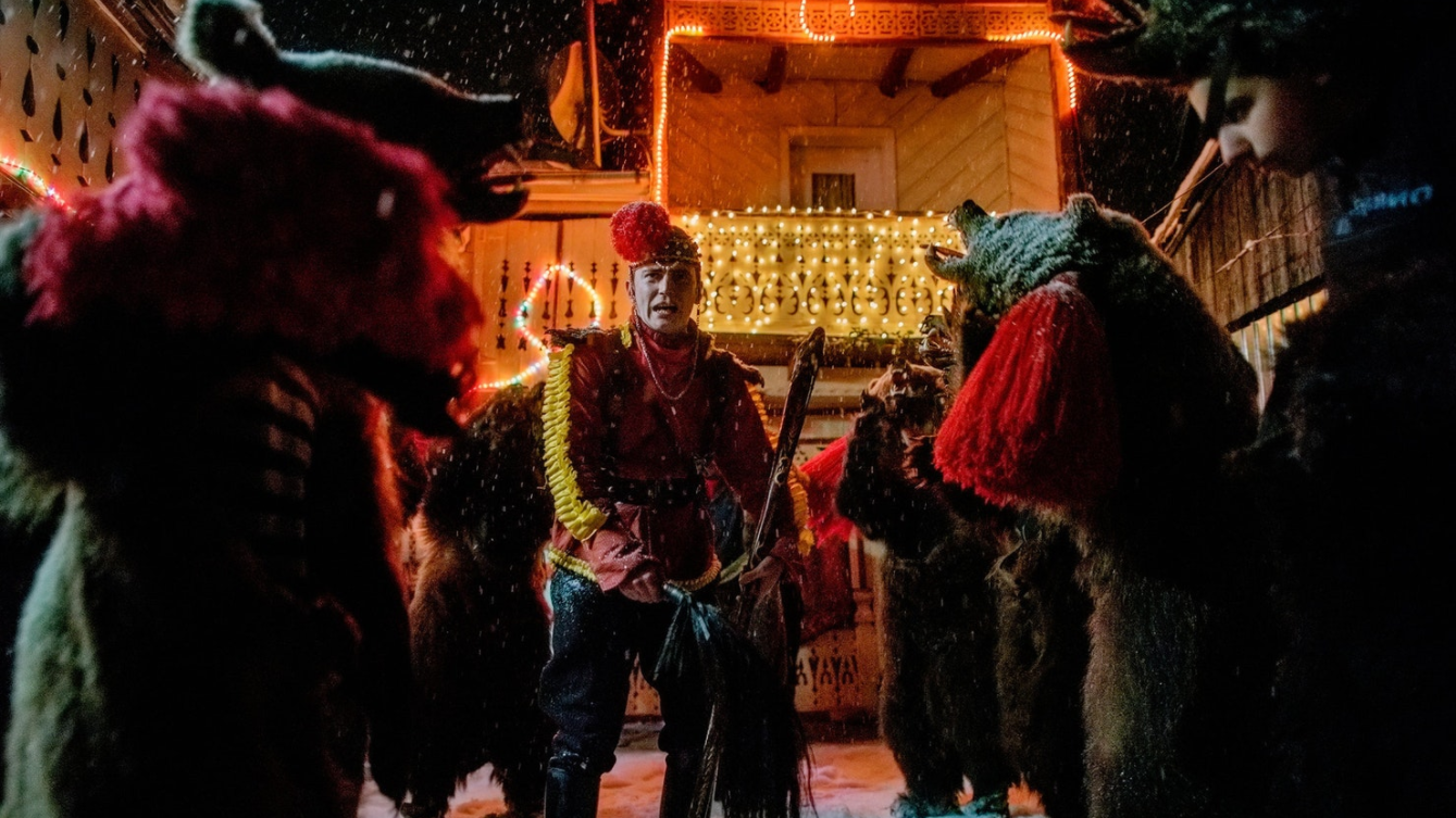
Toloaca’s bears dance and encircle their tamer, Gabriel Hanganu. After winning first place at Comanesti’s annual Bear Parade, Toloaca‘s troupe celebrated in the streets, singing, dancing and toasting with homemade palinka liquor handed out by residents. Asău, Bacău, Romania


THIS ARTICLE WAS ORIGINALLY PUBLISHED ON MAPTIA.


DIANA ZEYNEB ALHINDAWI

Diana is a photographer working internationally on stories about humanitarian, human rights, or cultural issues.

Into the Outback

An epic and ancient landscape, deeply entwined with the artistic, musical, and spiritual traditions of Indigenous Australians, the Outback is one of the largest remaining, intact natural areas on Earth. A cultural, ecological, and geological wonder, I explore and capture these vibrant regions on foot and from the air.
 

Known for its Aboriginal peoples and its vast, ancient landscapes, the Outback is an incredibly special place for me. I think that once you get that distinctive red dust in your blood it never comes out.

My roots are deeply connected to the rural areas of western Queensland and from a very young age, the never-ending expanse of inland Australia has been something that has captivated me. Ever since I can remember, we would take long road trips out to a family-run cattle station, and there was always this great sense of wonder and adventure. In the Outback, you can travel for days in any direction and stumble across places that are unique, untouched, and rarely visited. It was on these early trips that I fell in love with the bush, the people, and its landscape. I’ve never stopped venturing back.

Pannawonica Hill, near the small town of Pannawonica, a tiny iron-ore mining settlement in the Pilbara region of Western Australia. // © Dan Proud

Drawn to remote, wide open spaces, to the dusty and the desolate, I have found that there are countless unique rocky outcrops and ridges to explore. From the arid and ancient regions of Kimberly and Pilbara in Western Australia, to the rugged, weathered peaks and dramatic rocky gorges found in the Flinders Ranges of South Australia, to the red centre and Australia’s most famous monolith, Uluru — it is not only the sheer size of the Outback that is astounding (it could encompass almost all of Europe), it is also home to some of the world’s most spectacular and untouched landscapes. Over the past few years, I’ve been lucky enough to photograph, film, and fly over these regions — both in light aircraft, and more recently, with drones.
 

The West MacDonnell Ranges, known as the West Macs, seen from the air. Found in Australia’s Red Centre, west of Alice Springs. // © Dan Proud

Deeply entwined with the landscape itself are the artistic, musical, and spiritual traditions of the Indigenous Australians, among the longest surviving cultural traditions in human history. Some 30,000 to 70,000 years ago — many millennia before the European colonisation that would come to threaten and profoundly disrupt many Aboriginal communities — the first inhabitants of Australia arrived from the north, making them amongst the world’s earlier mariners. They spread throughout the landmass, surviving even the harsh climatic conditions of the Last Glacial Maximum.

Evidence of ancient Aboriginal art is found all over the Outback, most notably at Uluru and Kakadu National Park in the Northern Territory. An impressive sandstone rock formation, Uluṟu — as it called by the Pitjantjatjara Anangu, the Aboriginal people of the area — or Ayers Rock, still holds great sacred and cultural significance for the local indigenous population. Appearing to change color at different times of year, this natural monolith is quite magnificent as it glows a deep red or purple at sunrise and sunset.
 

Uluru, or Ayers Rock, the huge sandstone monolith in Australia’s Red Centre, glows deep red at sunset. // © Dan Proud

It was only in 1606, little over four centuries ago, that the first known European landing was made by Dutch navigator Willem Janszoon on the western shore of Cape York, in Queensland. This discovery was closely followed by that of Dirk Hartog, another Dutch explorer, who sailed off course during a voyage in 1616 and landed on what is now known as Cape Inscription, thus discovering the coast of Western Australia.

For many decades to come, the true extent of the continent would not be known, and with the exception of further Dutch visits to the west, Australia remained largely unvisited. Although a number of shipwrecks are evidence that other Dutch and British navigators did encounter the coast during the 17th century, usually unintentionally, it would be over 150 years before the crew of HMS Endeavour, under the command of British explorer Lieutenant James Cook, sighted the east coast of Australia in 1770 and Europeans widely came to believe that the great, fabled southern continent existed.
 

Trees in stark contrast with the vibrant orange of Uluru, or Ayers Rock. // © Dan Proud

Running in parallel ridges to the east and west of Alice Springs, through Australia’s Red Centre, lie the East and West MacDonnell Ranges, also known as the Macs. Most people imagine the Outback to be completely flat, but these mountains run for more than 600 kilometres and in places reach heights of over 1,500 metres. Formed 300 to 350 million years ago, folding, faulting, and erosion have since shaped the Macs to form numerous narrow gaps and gorges, and they contain many areas of cultural significance. Seen from the air, their undulating and intricate rock formations are spectacular.
 

The West MacDonnell Ranges seen from the air, in Australia’s Red Centre, west of Alice Springs. // © Dan Proud

Weather patterns in the Outback are also something that surprises many people. While often envisaged as a uniformly arid area, the Outback regions stretch from the northern to southern Australian coastlines, and encompass a number of climatic zones — including tropical and monsoonal climates in northern areas and temperate climates in the southerly regions. At times, dramatic dust and thunder storms roll in, soaking the dry ground and often causing flash flooding. Witnessing these storms is an incredible experience.
 

Dust and thunder storm meet near the tiny settlement of Innamincka, Southern Australia. Situated on the banks of Cooper Creek, it is surrounded by the Strzelecki, Tirari and Sturt Stony Deserts. // © Dan Proud

Reflecting its wide climatic and geological variation, the Outback contains a number of distinctive and ecologically-rich ecosystems, along with many well-adapted animals, such as the red kangaroo, the emu, and the dingo, which are often to be found hidden in the bushes to keep cool during the heat of the day. Recognised as one of the largest remaining, intact natural areas on Earth, the Outback is home to many important endemic species.

One such species is Adansonia gregorii, known locally as the boab tree, which is found nowhere else in the world but the Kimberley region of Western Australia, and east into the Northern Territory. With their striking swollen trunks, boab trees can reach up to five metres in diameter at their base, and amazingly, some individual trees are more than 1,500 years old, making them the oldest living beings in Australia, and among the oldest in the world.

For thousands of years, Indigenous Australians have used these giants for shelter, food and medicine; often collecting water from hollows within the tree, and using the white powder that fills the seed pods as food. Decorative paintings or carvings were also made on the outer surface of the fruit.
 

A boab tree growing in the Kimberly region of Western Australia. // © Dan Proud

Also found in the Kimberly region is the Cockburn Range, a magnificent sandstone escarpment that rises for 600 metres above the surrounding plains. Shaped like a vast fortress with towering orange cliffs, many rivers have cut through the formation to form steep-sided gorges. Flying above the Range at sunset, when the western face is lit up with a brilliant red glow, reveals another of the Outback’s epic and ancient landscapes.
 

Sunset flight over the Cockburn Ranges in Kimberley, Western Australia. // © Dan Proud

The geology of South Australia’s Outback is no less dramatic, and among the rugged, weathered peaks and rocky gorges of the Flinders Ranges, some of the oldest fossil evidence of animal life was discovered in 1946, in the Ediacara Hills. Similar fossils have been found in the Ranges since, but their locations are kept a closely guarded secret to protect these unique sites.
 

Cast in golden light, Bunyeroo Valley in Southern Australia. // © Dan Proud

The first humans to inhabit the Flinders Ranges were the Adnyamathanha people — meaning “hill people” or “rock people” — whose descendants still reside in the area, and also the Ndajurri people, who no longer exist. Cave paintings and rock engravings tell us that the Adnyamathanha have lived in this region for tens of thousands of years. Though my perspective is usually broad and from the air, in the nooks and crannies of these arid landscapes live the yellow-footed rock-wallaby, which neared extinction after the arrival of Europeans due to hunting and predation by foxes, and also two of the world’s smallest marsupials — the endangered dunnart, and the nocturnal, secretive planigale, smallest of all, often weighing less then five grams.
 

The dramatic Flinders Ranges of Southern Australia seen from above, photographed by drone. // © Dan Proud

Last but certainly not least, we come to the spectacular Pilbara region of Western Australia. Stretching over a vast area of more than 500,000 square kilometres in the north of Western Australia, it is home to some of Earth’s oldest rock formations, dating back an impressive two billion years.

Seen from the air, parts of the Pilbara can sometimes resemble another planet. Yet the greens and yellows of the acacia trees, the hardy shrubs, and the drought-resistant Triodia spinifex grasses — contrasting so spectacularly with the brilliant orange and ochre of the land itself — remind us that life can flourish and adapt even in the most challenging of conditions.
 

The vibrant colors and unusual contours of the mineral-rich Pilbara landscape in Western Australia. // © Dan Proud

Known also for its vast mineral deposits, for many years the Pilbara has been a mining powerhouse for crude oil, natural gas, salt, and iron ore. Today, although the fragile ecosystems of this area have been damaged by these extractive industries, a number of Aboriginal and environmentally sensitive areas now have protected status in the Pilbara — including the stark and beautiful Karijini National Park with its deep gorges and striking canyons.
 

Stunning displays of rock layers at Hancock Gorge in the Pilbara. // © Dan Proud

Culturally, Australia’s Outback regions will always be deeply ingrained in our country’s heritage, history, and folklore. For Indigenous Australians, creation of the land itself is believed to be the work of heroic ancestral figures who traveled across a formless expanse, creating sacred sites on their travels. Ecologically, it is one of the most untouched and intact natural areas we have left on the planet, and home to a plethora of important endemic species. Geologically, it represents a vast and ancient landscape — one of the most unique on Earth and one that I could never tire of exploring. Every time I head up into the air or set out to photograph the Outback, I’m blown away.
 

Dotted with acacia trees, the striking landscape of Pilbara’s Outback region at dusk. // © Dan Proud


THIS ARTICLE WAS ORIGINALLY PUBLISHED ON MAPTIA.


DAN PROUD

Dan Proud is a Queensland-based photographer and film maker with a passion for aerial cinematography and capturing the magical wide open spaces of Australia. 

Life on the Margins

During the northern summer of 2001 thousands of Chinese security personnel, backed by an army of labourers armed with sledgehammers, massed at the entry of the Larung Gar Tibetan Buddhist Institute. In this almost impossibly remote place, sitting high on the Tibetan Plateau, 9,000 monks and nuns had found a home, defying decades of China’s aggressive atheist policies to learn from its charismatic and avowedly apolitical founder, Khenpo Jigme Phuntsok.  

PRC authorities had long been skittish about the institute’s remarkable growth, and particularly alarmed by its growing appeal to ordinary Han Chinese. By 2001 over 1,000 Han also called Larung Gar home.
 

The Larung Gar Five Sciences Buddhist Institute.

Both Larung Gar and Yarchen Gar (gar translates as camp) have remained largely hidden from the outside world, as much because of their inaccessible geography as the tight controls on freedom of movement put in place by the Chinese government. Both sit at elevations of over 4,000 metres, sunk deep into hidden valleys of the Hengduan mountain range, which cuts across China’s south-western Sichuan province.
 

Yarchen Gar sits hard against the border of the TAR and is home to roughly 9,000 nuns. 
 

Both Yarchen and Larung Gar are part of what is known as the Garzê Semi Autonomous Prefecture, where 77 percent of the inhabitants — some 800,000 people — claim ethnic Tibetan heritage. As is the case in the similarly named Tibetan Autonomous Region (TAR), the people’s future has long been out of their own hands.

In theory, to move around Garzê as a foreigner, one only needs a Chinese tourist visa and bucket loads of time, patience and fortitude. This is in stark contrast to the neighbouring TAR, at the border of the lands known to the wider world as ‘Tibet’. Visitors to the TAR are required to first negotiate a complex and shifting permit process, before joining an organised and highly controlled tour of the region.
 

Nuns at a ceremony at Yarchen Gar in which almost the entire population of the camp leaves for a month of meditation in the surrounding hills. 

Yet Garzê and nearby Qinghai are also restive. Tibetans here have openly protested against Chinese control, most notably as part of a violent uprising in 2008. Referred to by the Chinese as the 3-14 riots, unrest had spread from the TAR into Sichuan. This unrest effectively slammed the door shut to the region’s hidden treasures until 2013. Today, despite relative calm, nuns and monks continue to take the extreme measure of self-immolation in towns and villages. Reports of random arrests and the disappearance of accused activists are common. Recently Garzê has been open, yet regulations can change overnight and information is scarce. 
 

The narrow, winding alleyways of Larung Gar.

During China’s breakneck boom the mountainous Garzê region represents ground zero in the great ‘go west’ campaign — viewed by the People’s Republic as integral to the rapid growth of the Chinese economy. 

The wealth of natural resources found here, as well as the nation-building railway into Tibet (completed in 2006) have been the catalyst for extraordinary development. In the regional town of Sertar, which sits astride the Larung Gar complex, the reality of the security situation quickly hits home. I was challenged in the main square and taken to police headquarters to sign in and face a barrage of questions.

Mercifully, one officer spoke English and took my story of being a history teacher at face value. This would be just one of my almost daily encounters with the local police force over the coming weeks.

The main street through Yarchen Gar

Monks debating at Larung Gar.

During the following days I was left free to explore the vast warren of huts, temples and study houses that surround the complex. One morning I witnessed a loud monks’ debate; where the men and boys almost come to blows over competing theological arguments.

The monks and nuns live their lives separated by the main road which slices Larung Gar camp down the middle. I found both groups to be generally welcoming and curious, and the tinderbox atmosphere and police presence of Sertar is replaced by the constant hum of worship, with the sound of prayer and Tibetan horns a constant.
 

Monks in study and debate at Larung Gar. 

Many Chinese tourists visit Larung too. The biggest draw for them turns out to be the opportunity to witness a traditional Tibetan ‘Sky Burial’. At 1pm every day, the Rogyapa (“body breaker”) arrives to dismember recent human remains, which are then fed to aggressive flocks of resident vultures on a hillside set back from the complex.

Macabre to some, this ancient ritual is both a practical way of disposing of human remains whilst also adhering to jhator, the principle of kindness to all living things, which includes feeding these huge carrion creatures. Few of traditional these sky burial locations remain operational, mainly due to religious marginalisation, urbanisation and the decimation of vulture populations.
 

The vultures who are fed during the traditional ‘Sky Burial’ on the hillside above Larung Gar. 

The institute at Larung Gar currently attracts followers of Tibetan Buddhism from all over China. Its regrowth after the 2001 evictions was swift; students began to illegally return and rebuild almost immediately. After Jigme’s death in 2004, countless followers made a pilgrimage to Larung Gar to pay homage to their spiritual master. Many stayed and contributed to the already rapid regrowth of the population. Today, Larung Gar is home to an estimated population of 50,000 people.
 

Gar camp from above, on rare clear day.

Yarchen Gar, founded in 1985 hard against the border of the TAR, has deplorable living conditions. Without even basic sanitation, every corner of the complex is permeated by a breathtakingly toxic smell.  Around 9,000 nuns live in ramshackle huts on an island, while the more solidly built monks’ quarters sit more favourably on the surrounding hills. Monsoon rains bring regular flooding; on my visit ankle-deep raw sewage flowed into the streets on more than one occasion. 

Rains in Yarchen Gar flood the streets with raw sewage.

No electricity runs to the island where the nuns live. Cholera and typhoid outbreaks are a daily threat. In winter, the temperatures plunge to a life-threatening minus 25 degrees. Yet this does not deter the nuns. Winter meditation sessions, referred to as the “direct crossing”, can last for days, with nothing more than a blanket to shield worshippers from the cold.
 

Sunrise at Yarchen

 The reward for this remarkable display of self-deprivation is the chance to learn first-hand from some of the most revered figures in Tibetan Buddhism. The current leader in residence is Asong Tulku. ‘Tulku’ is a title given to a person who has reached the highest level of spiritual enlightenment, and Asong is considered a living Buddha by his followers. To assist in his teaching at Yarchen, Asong is aided by senior nuns, called khenmos. Many nuns begin their life here at the age of just six.
 

Worshippers inside one of the temples at Yarchen Gar.

The bridge over to the island where the nun’s live.

Not only do the nuns dedicate themselves fully to their studies, they are also responsible for almost all physical labour at Yarchen, constructing houses, unloading trucks or building roads. The monks, who rarely participate in physical labour here, seem to have it easy in comparison.
 

Building a basic meditation hut on the hills overlooking the nun’s encampment.

The nuns carry out most of the hard physical labour at Yarchen. 
 

Despite the challenging living conditions, vast amounts of money are being funnelled into gigantic, ornate temples and monuments in the heart of the camp, while the surrounding slums continue to crumble.

Han Chinese money has poured into this region, with relatively wealthy converts to Tibetan Buddhism bringing much needed funds to the camps. These wealthy benefactors, hoping to improve their karma for the next business deal, or through a “cover all bases” spiritual mentality, have sparked a huge construction boom on the far western Chinese frontier.

A young nun exits an area reserved for eating and socialising in the centre of Yarchen. 

During my time in Yarchen I had several memorable brushes with the revered leader, Asong Tulku. As he piloted his gleaming white Lexus around the slum, our paths would meet on my early morning photo shoots. Watching people fall into the putrid mud at his feet wherever he walked, all rushing to pay tribute with cash and gifts, I found myself wondering if the money for the Lexus couldn’t be better spent elsewhere.
 

Asong Tulku is considered a living Buddha by his followers

The abrupt change from the monsoon season to the biting cold of winter was a fortuitous time to be visiting Yarchen. A ceremony in which almost the entire population of nuns empty from the confines of their island home for a month of meditation in the hills was due to take place. For days, preparations for this ritual, translating roughly to the “circle of life”, had provided a preview of what was to come.
 

Young monks taking a break from daily classes at Yarchen.

Basic supplies were taken by foot to a hidden nook outside the complex, the location of which was strictly off limits to outsiders. When the fortuitous day finally arrived, the sight of 9,000 nuns in their bright red robes streaming into the hills was a privilege to see.
 

The nuns of Yarchen Gar prepare to walk into the hills for a month of meditation.

At the entrance to the valley I reached a sign hammered into the ground, with a message written in bold letters, announcing that any man who followed the nuns on their trek would return blind. With this, I knew that my luck had held out for long enough; it was time to go.
 

Larung Gar camp by night. 

By rights Larung Gar and Yarchen Gar shouldn’t exist, and at different times the authorities have tried to sweep them away. Draconian restrictions on the freedom of movement and religious practices in the TAR itself means that nothing exists there to rival these two sites.

Quite possibly, the future leadership of Tibetan Buddhism rests not within the more recognisable white-washed walls of Lhasa’s hillside fortresses, or within the Dalai Lama’s inner circle, but within China itself.
 

Star trails arching over Yarchen Gar.


THIS ARTICLE WAS ORIGINALLY PUBLISHED ON MAPTIA.


BROOK MITCHELL

Brook Mitchell is a photographer + writer with Getty & The Sydney Morning Herald.

Visions of Kenya

A long time went by before I was able to understand this trip. Sometimes, the present is not understood until it becomes the past. Kenya belongs to a continent of origins, remote and distant, and for now, for better or worse, many of its vast and beautiful rural areas remain far from the globalised world.

In a matter of two weeks I had organised everything. Bought the tickets from Buenos Aires to Mombasa, got the necessary vaccines, packed my things and let my friends know I was leaving. “I’m going to Kenya for a month, alone, just my backpack and camera, nothing else.” It was a long flight to Mombasa. I was very tired and somewhat nervous about it all. At the airport in Mombasa the image of a rhino gave me goosebumps. I had arrived.

— Mombasa —

The first morning I was woken by the heat and the unrelenting racket made by the many crows that inhabit Mombasa. I looked outside the window to see Africa for the first time: bonfire smoke on the sides of the street, women selling fresh fruit right outside our building, next to them, I saw other women with beautiful braids in their hair, and a little further away, a man selling plants. Here, life takes place on the streets.

He was selling onions on the side of the road to Nairobi

I enjoy travelling alone and getting to know different cultures, in the most simple and genuine way possible, simply by being there, and merely observing. Trying not to alter what I see, to be inconspicuous. But in Mombasa, I was noticed right away. I am a white Argentinian, in a city where almost everyone is black. It was impossible to remain unseen.

Sunday morning is a social time for families at the public beach

The first few days were filled with nervousness and anxiety. I was alone in a place completely different to my own, full of tension and expectations about what the trip might become. Was I going to be able to adapt to Africa? I just wanted to let go, come to know the locals, let down my resistance, and give myself up to whatever had to happen.
 

Eddie lives inside a garbage container in Mombasa. The day I left Kenya, I gave Eddie all of my clothes.

Two days went by and I decided it was time to get out of the city. Venturing into the more rural areas of Kenya would be better than staying in Mombasa. Leaving my big backpack behind, I grabbed my camera, my flip flops, swimming trunks, and my kikoy — a traditional man’s wraparound worn on the Swahili coast of East Africa, especially in Kenya. It protected me from the sun and from the stares too. I took a tuk-tuk to the south of town, then a ferry, and then a three-hour matatu — one of Kenya’s colourful buses. My destination was Wasini Island, a small island in the south, where people usually snorkel for a few hours and then leave. I wanted to stay, at least for a few days.

School children on the road from Mombasa to Kilifi / She was sleeping in the matatu along the way.

I was greeted by Abdullah, who was surprised to meet a foreigner who wanted to stay longer than a few hours. I got on a small boat and crossed the island with two guys who were carrying huge machine guns, which they used to absentmindedly scratch their feet and faces — I had never seen such big weapons. 
 

Baobab tree lit up at night

— Wasini —

Wasini is a coral rock island that during its hey-day was a popular summer destination for retired and wealthy Europeans who wanted to enjoy the heat and beaches of Kenya. The day I arrived, there was just one dutchman and me, and the rest of the island was a small fisherman’s village. Abdullah cooked a fish for me with great care, and later made me visit the “tourist attractions,” which meant very little to me.


Coral stones in the Indian Ocean

I met someone who said he would take me over to the other side of the island along a path that would pass through the mangroves. I told him I had very little to tip him with, as I had left all my money in Mombasa. He gently insisted on taking me and I followed him. We walked through the island for a long time and I started to worry, thinking about where this stranger was actually taking me. The sun had started to set and as is common in many places in Kenya, there was no electric light.
 

We were crossing the path with this guy, while a fisherman was preparing his bait. I asked to take a picture of him, and he accepted.

We kept on walking until we finally reached the other side of the island. The mangrove trees continued all the way into the sea, and it was a very beautiful sight. I calmly took a breath, my guide had not deceived me. At that moment I felt that if I had managed to get to such a remote place with a complete stranger, then it meant that the rest of my trip would turn out alright. It was a feeling I had. Complete trust.
 

Among the mangroves

— Kilifi —

I spent a few days in Wasini and then returned to Mombasa to continue northwards along the coast, towards Kilifi. In Kilifi there was a very impressive hostel, but when I entered I had the feeling of being out from what I have been seeing. Luckily, I decided to walk towards the beach, where I found a beautiful sunset.
 

Little sisters playing together in a tree near their home.

The beach was deserted. It was actually an estuary, very serene. I loved rural Kenya, so far away from the cities. As I sat with my camera I saw a kid walking in the distance. As he approached me I waved, then he waved back and continued to walk. A few hours later, the kid returned and I went over to have a chat. He responded by asking me if I knew how to hunt crabs. His name was Buda.
 

Portrait of Buda

We became friends and I met all of his brothers and sisters as well. They were many, and lived on the coast with their aunts and cousins. Most families in Kenya live with their extended family, and the women are in charge of the houses. Men are absent most of the time, often spending time with friends, away from their homes.
 

Full of joy in the ocean / Fishermen and family in the early morning

I quickly became very fond of Buda and his siblings, and they became fond of me. Every time I came down to the beach, they would arrive to greet me. I spent whole days on the beach, sometimes helping them gather wood for making fires, or finding things their mother had asked for — I learnt a lot about their culture and way of life, which was not always easy. Buda and Nuzrah were the eldest siblings and spoke better English. They taught me a lot of words in Swahili, their native tongue.
 

Portrait of Nuzrah

One of the days we spent together I brought them a football, a water gun and a jumping rope. We played with them, they taught me beach games, and every now and then we would all go for a swim. It was with great grief that I said goodbye to these children, as I had to continue travelling towards the west of the country. They stayed with me until I left, and their mother also came to say goodbye.
 

Portrait of Buda / Jumping rope / Portrait of Mwanaisha

— Amboselli —

I took a tuk-tuk back to Mombasa, thinking about everything I was experiencing. It felt so powerful and different, making me reflect on my own life, and how grateful I was for the opportunity to travel. The following dayay I left for Amboselli National Park. Enormous and open, there were no fences around it. Animals are not easy to see. You might spend a whole day walking around and only encounter a few zebras.

Morning of the Zebras

But the immensity and beauty of the landscape was truly dazzling to me, sometimes reminding me of my native Patagonia, similarly wild and empty in its own way. I also thought about the devastation humans have caused to the natural environment, and the complex challenges local and international communities face as they attempt to tackle and reverse this.
 

Afternoon of the elephants

I spent my whole childhood fascinated by documentaries on Animal Planet, or Discovery Channel. I could not quite believe I was there, in these vast landscapes. The animals were so big, so strong. They had very little to do with the image I had of elephants in zoos or television. And the trees, they were so magical, I really have no words to describe them.
 

Masai walking in the early morning / Just a beautiful tree, in my first moments in the park

A long time went by before I was able to understand this trip. Sometimes, the present is not understood until it becomes the past. 

When I travel, I seek to explore places that will surprise and challenge me, and from that surprise create beautiful experiences and photographic visions of what I have witnessed. Kenya belongs to a continent of origins, remote and distant, and for now, for better or worse, many of its vast rural areas remain far from the globalised world.
 

Early morning at Tsavo. There is always magic in the first hours of the day.


THIS ARTICLE WAS ORIGINALLY PUBLISHED ON MAPTIA.


FRAN PROVEDO

Fran Provedo is a photographer and Architect from Argentina. Passionate about nature, and what is invisible in it.

KOREA: The Inner Lives of Korean Monks

Almost entirely cut off from the world, enclosed by mountains that resemble the petals of a lotus flower, lies one of the jewels of Korean Buddhism. As winter melted into spring, Alexandre Sattler lived alongside the monks, privileged to witness their daily lives and rituals.

"TEMPLE OF THE SPREADING PINE"

Looked upon as one of the Three Jewel Temples of Korea and renowned for its teaching of dharma — the eternal law of the cosmos, inherent in the very nature of things — today Songgwangsa is one of the foremost temples in the world for practising Korean Buddhism. In search of spiritual awakening, monks, pilgrims, believers and tourists all find their way here, to learn, meditate and exchange ideas.

Around 1190, Jinul, who was a master of seon, the Korean variant of Zen, stopped in front of an abandoned temple at the centre of a mountainous valley, where an abundant stream was flowing. He planted his stick in the ground and announced to his followers that in this place — from then on known as Gilsangsa — they were going to build a new temple.

According to legend, the stick took root, and is still waiting for Venerable Jinul to be reincarnate before flowering. This is how, at the very heart of what has become Jogyesan Provincial Park, a few tens of kilometres away from the sea, the prestigious temple of Songgwangsa — or “the Spreading Pine,” in keeping with one of its etymologies — now stands. Held to be one of Korea’s greatest national treasures, it currently falls under the jurisdiction of the Jogye Order, one of the branches of Korean Buddhism.

Almost entirely cut off from the outside world, Songgwangsa is enclosed by mountains, and wooden edifices occupy both sides of the stream which flows through the site. None of the spaces between the buildings is linear, as is often the case with traditional Japanese temples. Here, it seems as if man has reconciled himself to nature without attempting to impose upon it. Snakelike pathways move from one temple to another according to the whims of the contours.

To erect the temple, the monks-turned-builders depended on feng shui doctrine, favouring the feminine energies, or yin, of the place. It is said that the surrounding mountains resemble the leaves of an enormous lotus flower, whose stamens are represented the temple buildings. So as not to impede the flow of energies, the monks chose not to draw upon dome-like stûpa — synonymous with yang, or masculine energy — unlike the custom in other Korean temples.

I came to Songgwangsa in February, at the tail end of winter. It seemed as if Nature was still asleep. The sky was grey, the temperature barely more than five degrees. When the bus stopped at the terminal, the other travellers and I found ourselves standing at the foot of Mount Jogye. The climb up to the temple is magnificent. As you follow the banks of a waterway, slumbering pines appear out of the fog and the wind whistles softly in the bamboo plants. It takes around twenty minutes of quiet, contemplative walking to reach your destination.

Initially, I had thought that I would only spend four or five days at Songgwangsa, but the monks made me see that time should not be rushed, and that new things tend to come to us when we are prepared to receive them. On entering the reception room, I discovered first of all that I had been admitted on the basis of a misunderstanding. Journalists and photographers are usually sent to a different temple.

Despite this, I was granted an unadorned room with a mattress, blanket and pillow, which I would learn to fold carefully and tidy away in a little cupboard each morning. I came to realise that to write and take photographs, it would be necessary to be truly met with approval by the whole community. More than anything, I would need to commit myself to the daily rhythm of the monks, their rites and ceremonies.

After a time, I was accepted by the sangha. The monks became fond of coming to say hello and talk to me, and some of them regularly invited me to take tea in their cells. I formed a friendship with Dokejo Sunim, the senior monk in charge of instruction in dharma and also a photographer.

During my first week I learned to live as the monks do, following their teachings and taking part in their prayers, meals or daily tasks. But I was not yet allowed to capture the slightest image. It was actually only because every member of the assembled community gave their consent that I became the first photographer permitted to take shots of their ceremonial spaces, or of the incredibly intimate tonsure.

In fact, Dokejo Sunim told me that previously, no other professional had been trusted to take these kinds of photos, and that in all likelihood it would never happen again. For this reason, the photos I publish here are an exception of sorts. At the end of my stay, Dokejo Sunim even requested that each and every one of my shots be sent to him.

Upon my arrival at Songgwangsa, the monks had explained that the winter retreat was nearing its end, but invited me to stay until the first full moon of the new season. If I prolonged my stay, they suggested, I would be able to meet Venerable Hyon Gak Sunim, a monk well versed in English who would be able to have a more in-depth conversation with me. In the following weeks, although I became used to crossing paths with Venerable Hyon Gak Sunim, it was impossible for him to speak to me, as he had made a vow of silence for three months. So I decided to extend my stay and wait until the very end of his winter retreat.

“Buddhism is a science whose proposed theories are only proven after they have been experienced.”

I like this idea. They say that the Buddha used to end his addresses with the following, “Don’t believe what I tell you, experience it for yourselves.”

As spring took her first breath, so Venerable Hyon Gak Sunim emerged at last from his weeks of silence. He seemed happy about our encounter, which he led with incredible energy and presence. His voice often broke the room’s silence, and his words deeply affected me.

One day, I made the point that life in the temple felt distant from the material world lived in by much of humankind. I asked him my questions about meditation and the search for release which seems to be too inward-looking, while all around me I sense the urgency for change, to ensure a sustainable future for everyone. Why choose to pray here, I wondered, far from all of us, while we are in desperate need of spiritual light to make sense of our everyday actions and our place in the world?

“Prayers are like carbon reservoirs”

Venerable Hyon Gak Sunim explained to me that prayers are like trees, silently maintaining the vital balance of man and life on Earth. Each tree, no matter how large or small, acts as a “reservoir,” soaking up atmospheric carbon, unobtrusively helping to reduce the amount of carbon dioxide in the atmosphere, and lessening global warming as a result. Skimming over a forest, you see only the trees and their impact remains invisible. It is the same with prayer.

Coming to Korea, I could not help but compare this country to Japan, where I had lived previously. Knowing that Hyon Gak Sunim had also lived in Japan, I asked if he could explain the difference between Japanese and Korean Buddhism. He told me, “In Japan, people eat with chopsticks. In India, with their hands. In Europe, with a knife and fork. In Korea, people eat with a spoon and chopsticks… but at the end of the meal, they all have a full stomach! Whatever the technique, the result is the same, Buddhism simply offers different routes into enlightenment.”

This story has only become a reality through the involvement of all the monks at Songgwangsa and the help of Yong Joo An and Jieun Lee. All my thanks go to them. Original text translated from French by Zoë Sanders, Maptia.

ORIGINALLY PUBLISHED ON MAPTIA 


ALEXANDRE SATTLER

www.gaia-images.com 

Alexandre Sattler is a photographer, traveler, and producer of audio documentaries on our planet's diverse cultures. With an aim to showcase our shared humanity and the environment, more of his work is available on through gaia-images. 

VIDEO: E-Waste Tsunami in Delhi

A film to accompany the E-Waste Tsunami project. This film explores the industrialized landscape of the urban poor in a developing world metropolis. The urban poor are the community and sector of society to which the waste-picker and e-waste worker belong. The journey begins at the Bhalswa Landfill and associated communities in northwestern Delhi and then moves through the rapidly expanding infrastructure of the city. It concludes with a passage through unregulated housing developments that form a large part of this 21st century metropolis.

E-WASTE TSUNAMI

E-WASTE TSUNAMI peers behind the virtual world conjured by our computers and mobile phones to the very real world of electronic trash.

The ecosystems of production and consumption create the ecosystem of the receiver. In the receiver ecosystem are the environment into which products and materials are disposed, and the urban poor who work in the informal labor sector, generally in unregulated conditions
and facilities. Increasing consumer affluence, population growth, and decreasing product prices exponentially accelerate the e-waste problem. This project documents what’s happening at the frontline in the world of the receiver in a developing economy.

The photographic documentary, and film, produced by StudioFYNN,  provide a glimpse into the lives of those who work with e-waste on a daily basis in Bhalswa and Mustafabad, Delhi, India. While alternatives to toxic labor practices exist, only a handful of socially conscious and technologically equipped facilities are committed tobest practices with e-waste end-of-lifecycle. Given this highly complex problem, in what generative ways can diverse fields (such as industrialdesign, psychology, or urban policy) begin to model a more sustainable future?

PHOTOGRAPHS BY SHAUN FYNN

Want to see more? Check out STUDIOFYNN's Delhi Journey, an accompanying film for the E-Waste Tsunami project. 

SHAUN FYNN

@studiofynn 

Shaun Fynn is an acclaimed designer with over 20 years experience in advising and creating for Fortune 500 companies. Since founding STUDIOFYNN in 1997, he has developed the practice globally, working in areas of design research, photo documentary and design education. E-Waste Tsunami — a project that peers behind our virtual worlds to capture the real world of electronic trash — was on exhibition in The Sheila C. Johnson Design Center's Arnold and Sheila Aronson Galleries in New York City at the beginning of 2016. 

IRAN: A Look Inside

Impressions and moments captured from behind Iran's closed curtain, as Brook Mitchell traversed the Islamic Republic during the country's "Ten Days of Dawn" celebrations and rallies, to mark the anniversary of the 1979 revolution. 

Each year on February 1st — the date Iran’s former supreme leader Ayatollah Khomeini returned to the country in 1979, after 15 years of exile — the Islamic Republic begins its annual “Ten Days of Dawn” celebrations. The tenth day marks the date that Shah Mohammad Reza Pahlavi’s regime officially collapsed, and events are held throughout the country to commemorate the anniversary of the 1979 revolution.

The celebrations offer the state-controlled media the opportunity to portray a people united behind the country’s leadership, with appeals to a sense of nostalgia, national pride and Islamic unity.  Just how much of this rhetoric really hits home with the people of Iran is hard to know.

Most travelers returning from Iran will tell you about the legendary hospitality and natural curiosity of locals toward outsiders.

This was certainly my experience. Traveling solo, spending time in both the major cities and some of the smaller, more remote and down-trodden settlements, I was always made to feel welcome. I also never questioned my safety, except for some white-knuckle taxi rides through Tehran.

My goal was simply to see and shoot as much as I could while I had the chance. I experienced few issues taking pictures, and especially outside the major cities people were surprisingly open to being photographed. 

Below is Khaju Bridge in Isfahan at sunset. The bridge and its banks are a popular meeting place for young people and local families.  

Despite the welcome, traveling at this time of year it was abundantly clear that some older attitudes die hard. Although much of the hype surrounding the anniversary of the 1979 revolution appeared to be artificially whipped up by the authorities, the sight of young children propped up on their parent’s shoulders, holding placards that called for the death of the Islamic State’s perceived enemies, was hard to ignore.

In the city of Yazd I clambered up some dodgy scaffolding to take the picture below, which was one of the more surreal experiences of my trip. Even as the revolution celebrations reached fever pitch, most people simply waved and smiled, despite the hostile sentiment.

The former US embassy in the capital city of Tehran remains in much the same state as shown in the movie Argo. Now something of a museum, complete with wax figures representing former embassy staff, it is only technically open to visitors a few days each year. Anti-American murals such as those below have long been part of the urban landscape in Iran.

From these grisly monuments and stark murals around the former US embassy, to the huge national protests, rallies, and celebrations held throughout the first ten days of February, there were constant reminders that reconciliation with the West still has some way to go.

Above: Khaju Bridge in Isfahan 

However, not long after my visit a number of major steps towards this seemingly improbable reconciliation took place. Today, with the prospect of economic sanctions being fully lifted, the authorities are promoting the lofty goal of making tourism one of the country’s largest exports.  

Below is an image of a fellow tourist who spent the better part of an hour posing for pictures for her friends at the beautiful Nasīr al-Mulk Mosque in Shiraz. The building is famous for the early morning light cast through its ornate stained glass windows.

Lifting the sanctions will hopefully remove two of the more significant difficulties faced by travelers to the country. At the time of my visit, Iran was almost completely cut off from the international banking system, leaving independent travelers with little or no access to funds, even in an emergency. This meant carrying all the cash I needed for my entire trip.

Above: Nasīr al-Mulk Mosque 

Added to this was the famously difficult visa situation. I arrived into Tehran at 3.00am armed only with a letter of invitation, which had been paid for in advance via a numbered Swiss bank account. After a cursory check over my documents, a friendly though wary customs officer disappeared into a back room to discuss my situation with a superior.  

After what seemed like an hour he returned, smiled, and welcomed me to the country with a crunching stamp across my newly minted visa. After all the tension, I half went to high five the officer — the pressure was off.

Yet these relatively minor inconveniences pale into insignificance compared to the challenges the Iranian people have had to endure under the crippling economic sanctions brought on by the bluster of their uncompromising, theocratic leaders. Hyper inflation had brought their country’s economy to a grinding halt. 

Below is a man bearing a placard with images of the supreme leader of Iran, Ali Khamenei, and the ‘the eternal religious and political leader of Iran,’ Ruhollah Khomeini.

The struggling economy, coupled with instability and insecurity, have pushed many to seek a better life outside of Iran, seeking refuge in Europe, the US, and beyond. For a brief period Iranian asylum seekers had also been arriving in large numbers via perilous boat journeys to my home country, arriving on Australia’s north coast from ports in Indonesia. Boat arrivals in Australia are presently not allowed to stay in the country and are shipped off to the small islands of Naru and Manus for deportation or relocation to third countries, most recently Cambodia.

For all the genuine pride in their country people showed me, there were just as many stories from people hoping to leave, by any means possible.

From a taxi driver who showed myself and some other travelers photos of his lacerated back after he was given lashes for drinking home made beer, to an older man who brought himself to tears talking of his beloved brother, shot by the police for translating books into English a decade earlier, it was clear that many living in Iran have extremely good reasons to search for a better life elsewhere.

Below is a young girl and her mother leaning over the graves of some of those who lost their lives fighting during the 1979 revolution.

Yet from a traveler’s perspective the country is incredible.

Everything is cheap and the standard of hotels and food is generally pretty good. Mercifully, moving forests of selfie sticks are nowhere to be found. Well-known spots were busy at times, but never so much as to feel over crowded. Time will tell how long this will continue to be the case.

Below is Naqsh-e Rustam, an ancient necropolis with an impressive group of ancient rock reliefs cut and carved into the cliff. The oldest relief dates back to around 1,000 BC.

Below are two stone bulls flanking the north side of the Throne Hall at the UNESCO world Heritage site of Persepolis. Literally translating to “city of Persians,” the city Persepolis was the ceremonial capital of the Achaemenid Empire, from around 550–330 BC.

Near Yazd are the ancient Zoroastrian ‘Towers of Silence.’ The Zoroastrians ‘purified’ their dead by exposing the bodies to the elements and to birds of prey, on top of these flat-topped towers, called dakhmas.

While in the city of Isfahan, I visited the beautiful Sheikh Lotfollah Mosque. Along with the Naghsh-e Jahan Square on which it borders, the mosque is a UNESCO World Heritage Site. Early mornings see brilliant rays of light illuminate the intricate tile work of the building.

Also in Isfahan is Vank Cathederal, established by Armenian deportees settled by Shah Abbas I after the Ottoman War of 1603–1605. Today, this building remains one of the few Christian places of worship in Iran, and has many beautiful, fading murals within its interior.

One of the most interesting areas I explored during my visit was the southern region of the country, particularly the small islands and towns along the Persian Gulf coast. Thanks to the region’s colonial history as both a slave trading port and a stop on ancient trading routes, the area is home to the most ethnically diverse people in the country. 

One morning I shared a simple breakfast of fruit and tea with the woman below, and afterwards she was happy for me to take her picture.

The capital city of this region is called Bandar Abbas, and is a major port for smuggled goods coming from Dubai and Oman. It is home to the Bandari ethnic group, which literally translates as ‘people of the port’.

The locals here dress colourfully and still practice many customs that differ somewhat from the rest of the country. For me, it was the potential for some colour and a break from the dark chador worn throughout much of Iran, that made it so appealing to visit.

Early one evening in Bandar Abbas, I paused alongside a large crowd gathered to watch a sideshow, a common sight in the region. 

Below is a group of young men working to fix an Iranian built Paykan Taxi. When I returned to the city a week later, the men were still working on the cab, seemingly no closer to getting it moving.

Taking a short drive from the city of Bandar Abbas I arrived at the small town of Minab, seen below, where the people from around this vast area gather each week to sell their wares at the famous ‘Panjshambe Bazar’.

The striking coloured masks worn by the women of this region are said to have originated at a time when the Portuguese colonists would take the prettiest girls as slaves, and the masks would help to shield young girls from unwanted attention. I learned that each town in the region has its own signature variation of mask, varying in colour and construction.

The Panjshambe Bazar was a fascinating glimpse into the lives of the different cultures and people who call this area home. While there were large sections of the town dedicated to selling ubiquitous imported goods, there was still much to see that wouldn’t have changed much since Marco Polo made a visit — from the bustling livestock market, to the vendors selling colourful fabrics and homegrown produce.

For a fully grown, healthy goat, the prices seemed to hover around the 40 USD mark, a large sum of money for Iranians struggling in an economy crippled by sanctions and high inflation.

Below is a masked woman smoking tobacco from a waterpipe, or nargeela in Persian. This practice is banned for women throughout Iran in public places, but it remains popular amongst vendors at the market in Minab, who can often be found discreetly puffing away.

From tiny Minab I worked my way around to explore two rocky and arid islands just off the coast in the Persian Gulf, called Qeshm and Hormuz. On Hormuz, due to the severe lack of fresh water, Iranian engineers have constructed a water pipeline from the mainland.

Both islands are home to some of the oldest settlements in the Middle East, with a number of historic mosques and shrines, and I explored the crumbling ruins of ancient Portuguese castles and forts.

In 1507 the Portuguese conqueror Afonso de Albuquerque attacked the island of Hormuz, and it became a part of the Portuguese Empire. For over a hundred years, the Portuguese occupied the island, also capturing other islands and ports nearby, including the island of Qeshm. Their rule came to an end in 1622 when the Safavid king, Abbas I, conquered the Portuguese territories, forcing them to leave the Persian Gulf. Below you see remains of a chapel at the Portuguese fort on the island of Hormuz.

During 2009 Iran and Portugal prepared joint plans to restore historical sites in this region, however, little work seems to have taken place since then. These two young girls were passing through the ruins of the ancient Portuguese castle in the village of Laft, on Qeshm island.

Qeshm island is also home to large reserves of natural gas and a massive military presence. In early 2012, an underground military facility was established, designed to house Iran’s Ghadir-Nahang class submarines. The week after my visit a mock US warship was sunk just off the coast here by missiles fired from the main base in the east of the island.

Military service is mandatory for Iranian men. Except for special exemption cases, men not completing their service are unable to apply for a driving license, passport, or leave the country without permission.

Today the communities living on the islands of Hormuz and Qeshm are small, and in addition to natural gas exploration and production, fishing is one of the primary occupations for inhabitants of these islands.

Above you see a partially constructed Iranian lenge on Qeshm island, which is a traditional style of fishing vessel made of wood.

Above: (Left) A colourfully adorned house on Hormuz with a poster of Iran’s past and present. (Right) Women on Qeshm Island 

My hope is that the images shared in this story show a bit of both sides of Iran, as it is certainly a place that defies preconceptions.

Today, despite its beauty, rich history, and welcoming people, there is still a long way to go before it becomes a country where all of its people can feel safe, secure, and able to provide a better life for their children

Above: Morning light shines across the spectacular Nasīr al-Mulk Mosque in the city of Shiraz. The exterior of the building was completed in 1888. 


ORIGINALLY PUBLISHED ON MAPTIA  


BROOK MITCHELL

@brookmitchell

Brook Mitchell is a photographer and writer based in Sydney, Australia. His work ranges from local and national press for Getty Images and The Sydney Morning Herald, to longer form editorial articles and photo essays from around the globe.  

SOUTH KOREA: Surfing the Demilitarized Zone

38th Parallel Beach is located just 50 kilometres south of one of the most dangerous places on Earth — the line dividing North and South Korea. 


Known as sahm-parl in Korean (the numbers 3 and 8), 38th Parallel Beach is a harbour, military base, beach and a highway rest stop. Weary travelers can stop for strong, sweet coffee, spicy food and tacky souvenirs. They can inspect the coastline and enjoy the rare beauty of the Gangwando coastline. Today it is also a rather unusual surfing spot.

While living in Seoul working as a university teacher, I spent three years photographing and surfing with the Korean and foreign surfers who were establishing the area as a legitimate surfing community.

I was drawn in by bar tales spun by roughish Australians who said they had surfed with local Koreans in blizzards, but pre-Facebook and iPhones, proof was murky. Poor photos of clean waves in deep snow and a complex myriad of forecasting and unreliable local bus info made it even more confusing. Eventually these rumours led me down a three-hour stretch of highway from Seoul to the 38th Parallel on Korea’s east coast.

As I left, my Korean co-workers giggled at me for coming to the country with a surfboard, but a peninsula must have wind I thought — and where there is wind and water, well, there must be waves.

Arriving at a protected harbour I could immediately see some small but nicely shaped waves, peeling intermittently down a well-defined bank. I was impressed and could see its potential, so we jumped in.

It was a fun spot. Surprisingly, when we came in a film camera was shooting us as we came up the beach together. Turns out they were filming a commercial for nuclear waste storage and our water exit appealed to them. I posed for a photo with the bespectacled producer and later learned that we had made it into the commercial.

38th Parallel beach felt special from day one and this slightly surreal first experience would set the tone for my future visits.

In the months to come, I discovered some of the best waves I had seen in the country, and to my surprise there were a lot of surfers, too. Koreans, Kiwi surf rats, and even some wobbly Nova Scotians, all hunting for peaks to break the grind of Korean ex-pat life. The good surf days remain particularly vivid in my mind because my lowered expectations only amplified my ‘stoke’. The surf and culture on the east coast of Korea surprised me and my experiences were in a word, unique.

Surfing in Korea is tinged with madness and magic. Koreans tend to go full throttle with everything they do, and surfing is no different.

On a weekend, the line-up resembles a chaotic Korean market place with people and boards going every direction. Korea is small country with an enormous amount of people, so fighting for your position is a way of life and the surfing line-up is no different. Luckily, over 3ft Mother Nature takes control of the space politics and the line-up clears out significantly.

South Korea has gotten the surf bug badly, and 38th Parallel Beach has fast become a hub for Seoul’s young jet-setting surfer class, traveling down through scenic Gangwando to reach this barbed wired bay.

On any given day, and in any of Korea’s four distinct and extreme seasons, you will see trendies, gangsters, Hongdae hipsters, Gangnam DJs, and foreign English teachers all jostling for a wave.

The car park overflows on every swell with Seoul surfers chain-smoking in the latest gear and waxing up only the hippest of shapes. Koreans love to do things together, be it banquet-style eating, all night drinking, or raucous socialising. Surfing has become another activity to share and the entire culture is geared up for it with various surf stores and camps along the coast catering to the dedicated Seoul surfing clique.

With some of the most consistent and powerful waves in the country and with ever improving forecasting technology, modern social media and South Korean connectivity, the short lived swells that originate in the East Sea are no longer left un-surfed, even in the deepest of winter.

Koreans adore trends, and the newest trend, surfing is red hot. The surf community at 38th Parallel Beach has grown rapidly, enjoying a strange co-existence with the local fishing community and the ever-present ROK (Republic of Korea) defence force, who have been protecting South Korea from the distant threat of a North Korean attack or DPRK defectors since the 1950s.  

Being a lifelong surfer, the mixture of this semi-remote location, the exotic culture, and these three dramatically different groups all occupying the same space is incredible to me. Over the next few years I tried to spend as much time as I could out at 38th Parallel Beach, getting my surf fix and capturing the amazing and strange things I saw.


ORIGINALLY PUBLISHED ON MAPTIA


Shannon Aston

www.shannonaston.com

Shannon Aston is a world traveler, surfer, and photographer from New Zealand.