Check out the many green areas in NYC where culture and nature abound.
Read MoreYakutia: One of the Coldest Places on Earth
This Russian region experiences temperatures as low as -70F and its residents live drastically differently than people who live in warmer climes.
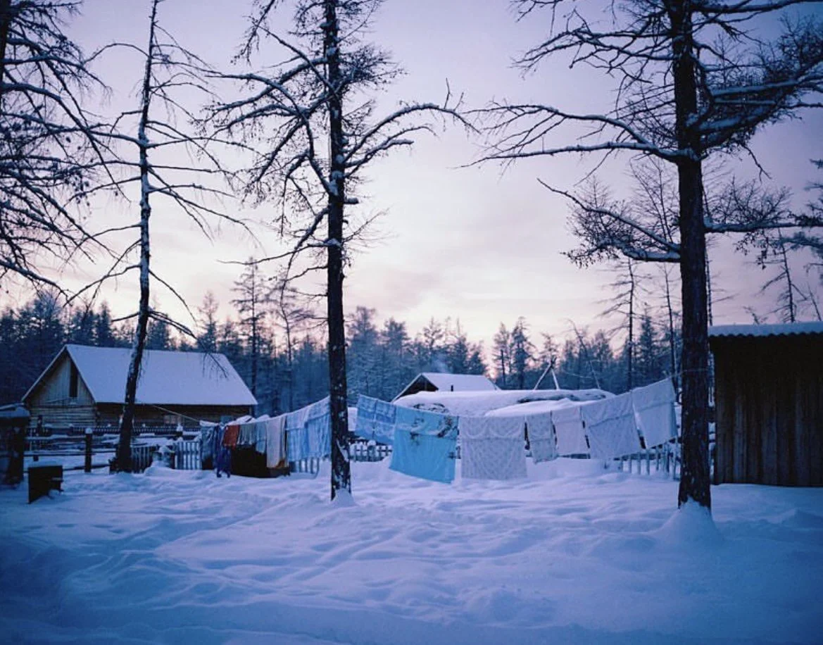
A village in Yakutia during the winter. @simoncroberts. Instagram.
It is seven AM. The sun hasn’t risen yet, but you’ve already gathered enough wood to heat your house for 9 months straight, in anticipation of the severe climate outside. You head to the back shed to grab the ice you harvested last November and put it in a giant tub of water to melt, ensuring that your family has something to drink when the water pipes will freeze. Now it’s time to make breakfast and wake your child up for school — because even though winter has finally arrived it’s warmer than -65 degrees Fahrenheit, which means it is safe to go outside.
This is how residents of the northern reaches of the Sakha Republic, common name Yakutia, live during the long winter months. Yakutia is located in Russia and is home to some of the coldest continuously inhabited places in the world. In villages like Oymyakon, located in the far north, the sun doesn’t rise until approximately 9am and sets at 2:15pm, meaning students have to walk to and from school in darkness.
Ten minutes in the cold, fresh air is enough to cause fatigue, stinging pain in any of the exposed parts of your face, and long-lasting aches in the fingers and toes. This is why many houses in the region are made of wood and built to withstand the extreme temperatures by filling every gap with oakum, a sealant made from plant fibers and tar, or even just the abundant snow, although the cold still finds its way through at times.
The Yakut people have learned to be productive in these conditions. Most men in the Republic’s far north have traditional jobs like cattle ranching, hunting, or making crafts, living lives that hardly resemble those of urban Russians. Knife-making plays an important role in the Yakut culture, with the blades known around the world for their strength and beauty.
Summer in a Yakutian village. @Kiun B. YouTube.
When summer comes around, Yakutia becomes a completely different place. While winter temperatures can plunge down to -70 degrees Fahrenheit, in the dog days of summer the weather can get to around 86 to 95 degrees, particularly at the end of July. Summers may be short-lived — only lasting 2.5 months — but it is also the busiest time of the year for Yakut people.
It is crucial to harvest berries before the frost sets in if one wants to eat fruit during the winter., A failure to harvest the hay needed to feed the cattle in time can lead families to lose their valuable livestock.
But with hard work comes a refreshing reward. During the summer, Yakutia turns from a snowy kingdom into a lush meadow full of dense forests. ManyYakuts take advantage of the balmy heat, and head straight to the nearest lake for a swim.
Yakutia is often called the land of rivers and lakes. There are over 700,000 rivers and 800,000 lakes that are rich with aquatic life, which is the perfect opportunity for Yakut people to stock up on food for the winter months.
Although Yakutia is by no means a popular tourist destination, the region is gaining more attention on YouTube and has fascinated viewers around the world. With increased visibility facilitated by modern communications technology , it will be no surprise if curious minds begin to pay attention to Yakutia.
Michelle Tian
Michelle is a senior at Boston University, majoring in journalism and minoring in philosophy. Her parents are first-generation immigrants from China, so her love for different cultures and traveling came naturally at a young age. After graduation, she hopes to continue sharing important messages through her work.
Where To Next? 20 Best Spots to Travel In 2023
From up-and-coming travel destinations like Rwanda to the otherworldly landscapes of Namibia, here’s the CATALYST list of the best places to travel in 2023.
Read MoreThe Ghostly Shores of the Namib Desert’s Skeleton Coast
Bones and wreckage meet biodiversity on the Skeleton Coast of the world's oldest desert.
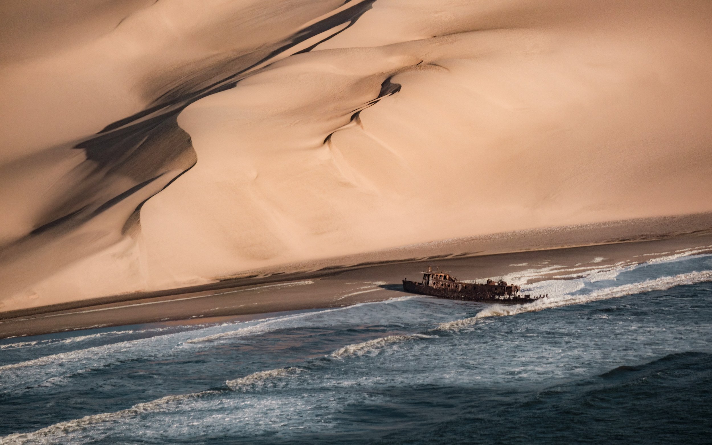
A ship wreckage by the red, sandy dunes along the Skeleton Coast. op23 | Unsplash
A map highlighting the Namib Desert in red along the coast of Africa.
Home to earthy-red dunes which roll right into the Atlantic ocean, the Namib Desert is thought to be between 50-80 millions years old, making it the oldest desert in the world. It’s also one of the world's most inhospitable places—an unpredictable, arid and remote region that on the surface has no appeal whatsoever. With temperatures fluctuating from blistering hot to dangerously cold and sand for as far as the eye can see, it extends from the country of Angola, through Namibia and down to South Africa. That’s over 31 thousand square miles of desert.
But don't be fooled, there’s more to these sandy plains than meets the eye. The Namib is home to the Skeleton Coast. And despite this desert’s penchant for death, The Skeleton Coast is teeming with rare wildlife.
What is the Skeleton Coast
The Skeleton Coast is on the northern shores of this ancient and unexpected desert and earned its macabre name from the whale and seal bones that once littered the shore from the whaling industry. The Ovahimba who have since settled in the far north-eastern parts of Namibia once used the whale bones for building their shelters. In modern times, the Skeleton Coast hides its infamous graveyard buried beneath the sand, and with the exception of a rare adventure seeker looking for a wave to surf, the odds of seeking a human along this part of the coast are slim.
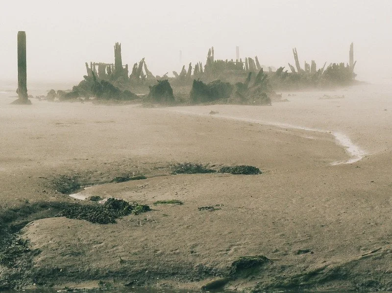
A shipwreck in the fog on the Skeleton Coast. Lee | CC BY 2.0
The Unique Climate of the Namib Desert
The bones scattered across Namibia’s Skeleton Coast aren’t from ocean mammals alone. Over the centuries, ships have ended up stranded on its shores for various reasons, but the main culprit is caused by the unique geography of the region. Hot, dry air from the interior of the continent and desert blows west combining with the cold wet air from Antarctica via a northward flowing ocean current called the Benguela Current. The hot dry winds act as a cap or roof not only prevents the cold wet air from escaping, but also from forming rain clouds. Instead, there is an eerie fog, and a lot of it.
In fact, for 180 days of the year there is fog on the Skeleton Coast so dense, it’s caused thousands upon thousands of ships to run aground throughout history; the oldest of which is from the 1500’s. The ocean's intense surf would have prevented anyone from getting back into the water, and with a wrecked ship, this meant that sailors stranded on this isolated coast were left with only one choice: to make their way through the Namib Desert. With a dryness rivaling South America’s Atacama Desert (the driest place on Earth), and sand dunes reaching nearly 1000 ft high, this option was nearly as dangerous as swimming out to sea and surely has added human bones to its burial collection.
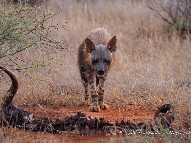
A brown hyena stands over a carcass in the Namib Desert. Joe Knapman | CC BY 2.0
Wildlife on the Skeleton Coast
Incredibly diverse, the Skeleton Coast has more near-endemic species than any other desert in the world. Elephants, black rhinos, desert lions, jackals, giraffes, seals, oryx, kudus and zebras and just some of the desert adapted species inhabiting this wilderness. One such animal is the brown hyaena. They’re usually on the move after darkness has fallen, which adds to their elusiveness. The name strandwolf was coined on Namibia’s Skeleton Coast where they scavenge for dead seals along the shoreline. If you are fortunate enough to spot one, make sure you take a really good look, because sightings of these inscrutable carnivores is never guaranteed. A truly endemic avian, the Dune Lark, inhabits thinly vegetated dunes along the Skeleton Coast and larger Namibian dune system associated with Bushman grasses and Nara melons.
A blooming welwitschias. Ragnhild&Neil Crawford |CC BY 2.0
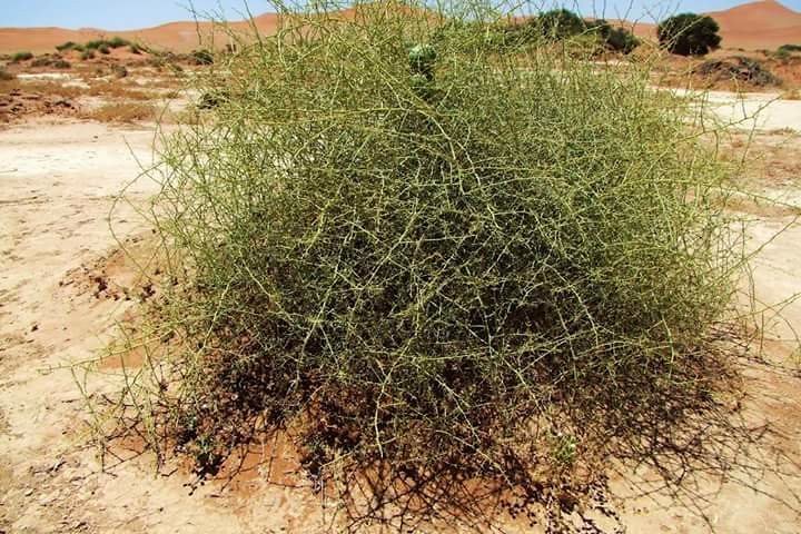
A spiny looking nara bush in the Namib Desert. Palmora| CC BY 2.0
Nara Melons are just one of the many plants incredibly adapted to the rainless area and depend solely on the warning fog from the Atlantic Ocean. The nara bush is of great importance not only to the people of the region, but it is ecologically key to maintaining the unique desert habitat. More plants include welwitschias—which is a dwarf tree with only two leaves that can live for several thousand years—several lithops succulent plants known as living stones, lichen, pencil bush and the vividly colored succulents of rainbow colored agate mountains dotting the shore.
The Lion’s Roar, a desert phenomenon
The phenomena of the Skeleton Coast doesn’t stop at bones, fog and compelling flora and fauna. Travelers, nomads and lost sailors once believed in the presence of desert spirits—singing songs through the mist. When the dunes form a bowl with the right acoustic properties, even a small flow of disturbed sand causes a terrific noise that resembles rolling thunder or even a low-flying airplane. The phenomenon is known locally on the Skeleton Coast as ‘the lion’s roar’.
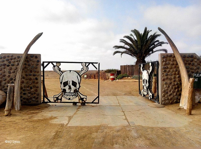
Ugab River Gate, Agnieszka Rysio | CC BY 2.0
The Skeleton Coast National Park
Luckily, this wildly unique, albeit creepy shoreline, along with its diverse inhabitants is protected. In 1971, Namibia established a well-maintained national park to protect the curious treasures, bones and wildlife which makes the Skeleton Coast so incredible. The park is divided into a northern and southern section; the southern section is open to travelers with four wheel drive vehicles who are welcomed to go as far north as the Ugab River Gate. There, they will be greeted by a sign with a skull and crossbones warning you to go no further. The northern section is off limits, its loose, enveloping sands will literally swallow you up and can therefore only be accessed by airplane with a certified guide. It also happens to be the most attractive region of the park with lunar-esque vistas as far as the eye can see. The park attracts all types of travelers, both local and international fishers, photographers, ecologists and folks just looking for a unique adventure to one of the world's most understated treasures.
Raeann Mason
Raeann is the Content and Community Manager at CATALYST, an avid traveler, digital storyteller and guide writer. She studied Mass Communication & Media at the Walter Cronkite School of Journalism where she found her passion for a/effective journalism and cultural exchange. An advocate of international solidarity and people's liberation, Raeann works to reshape the culture of travel and hospitality to be ethically sound and sustainable.
5 Islands to Visit in Indonesia Not Named Bali
While the famed island has its charms, visitors have largely overlooked the rest of this sprawling archipelago’s natural and cultural riches.
So much of Indonesia, such as Bunaken Island near Sulawesi, is relatively undiscovered – for now. Niek van Son. CC BY 2.0
Indonesia is made up of over 17,000 islands – yet the world’s attention focuses squarely on Bali. Yet, from the enchanting temples of Java to the crystal-clear waters of Raja Ampat, Indonesia’s less-known islands hold endless opportunities for exploration and enlightenment.
An orangutan sighting is all but assured in the jungles surrounding Sumatra’s Bukit Lawang. Hugo van den Bos. CC BY 2.0
Sumatra
Indonesia’s westernmost island offers up excitement and relaxation in equal quantities. The languid shores of Toba, the world’s largest volcanic lake, beckon visitors to its isolated islands, gushing waterfalls and unique Batak subculture. Elsewhere on Sumatra, adventure reigns supreme: track down orangutans in Bukit Lawang, surf mammoth waves on the surrounding Mentawai and Nias Islands or hike up the still-active Mount Sibayak volcano. Travelers can finish by polishing off some of Sumatra’s famously delicious cuisine in Medan and Padang, Indonesia’s most acclaimed culinary capitals.
As phenomenal as Raja Ampat’s diving is, the above-water scenery stuns just as much. Max Mossler. CC BY 2.0
Raja Ampat
Located just off the coast of New Guinea in Indonesia’s far east, this under-the-radar archipelago provides visitors with some of the most pristine reefs in the world. Skilled divers dream of traveling to these idyllic islands for all-but-assured sightings of sharks and manta rays and the discovery of over 1,000 different species of fish and coral. The views on land rival the bounty below, with a hike up Piaynemo Island revealing a dreamscape of verdant forests and crystal-clear waters obscured only by the flight of tropical birds.
The magic of Java best comes alive at Borobudur as the sun rises over the temple. Justine Hong. CC BY 2.0
Java
The world’s most populous island, Java remains the heartbeat of Indonesia. Frenetic and colorful Jakarta is a mixing bowl of Indonesia’s countless cultures as it attracts locals from every island. When the capital’s crush of humanity gets a bit too much, travelers can escape to atmospheric Yogyakarta, renowned as Indonesia’s cultural and artistic capital. Just outside of town are the architectural masterpieces of Borobudur, the world’s largest Buddhist temple, and Prambanan, Indonesia’s largest Hindu temple. Nature lovers appreciate a morning hike up Mount Bromo, while divers enjoy getaways to the tropical paradise of Karimunjawa.
Komodo dragons can be found nowhere else in the wild other than Flores and its neighboring islands. Adhi Rachdian. CC BY 2.0
Flores
Known by intrepid travelers for its Komodo dragons, Flores gives visitors a glimpse of an untouched Indonesian island tailor-made for adventure. Tracking down the region’s best-known inhabitant is a must, but travelers would be remiss to skip Flores’ less popular attractions. Padar Island’s coves alternate between white, black and pink sand, with their gorgeous beaches offering the perfect respite after a long day of trekking. Mount Kelimutu also revels in multihued splendor, with the volcano’s three lakes ranging in color from an intense red to cool shades of green and blue. Intense hikers will adore the overnight trek to Wae Rebo, an excursion through dense jungles to a traditional village set up by the Manggarai tribe.
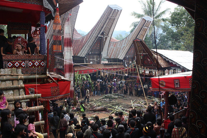
Funeral ceremonies in Tana Toraja are a cause for celebration, as death is the most revered state of one’s life. Arian Zwegers. CC BY 2.0
Sulawesi
Sulawesi holds an incredibly broad array of activities within its oddly shaped borders. The clear highlight is Tana Toraja, a highland region studded with rice paddies and filled with houses bearing a close resemblance to boats. The area is home to the world's most elaborate and celebratory funeral rituals, which mesmerize all who attend. Visitors take a bumpy ride into the jungles of Lore Lindu National Park to discover monkeys, snakes, and tropical flora and fauna that remain untouched by the outside world. A journey to Rammang Rammang passes by the sweeping limestone cliffs of the world’s third largest “stone garden,” and the Togean, Wakatobi and Bunaken Islands further entice with world-class diving opportunities.
Stephen Kenney
is a Journalism and Political Science double major at the University of North Carolina at Chapel Hill. He enjoys sharing his passion for geography with others by writing compelling stories from across the globe. In his free time, Stephen enjoys reading, long-distance running and rooting for the Tar Heels.
TikTok Travel: 20 Accounts That Take You Around the World
COVID-19 has kept many from traveling, but you can still explore the world on your phone with the app TikTok. Discover these top 20 accounts that will take you far from home.
Read MoreThe Largest Salt Flat in the World in Bolivia
Bolivia’s Salar de Uyuni is one of the country’s wonders. Despite the amount of tourists it still preserves its beauty.
Salar de Uyuni, Bolivia. Giacomo Buzzao. CC BY 2.0.
Located in the Andean Plateau in South America, the Salar de Uyuni is the largest salt flat in the world. It is in southwestern Bolivia, close to the border between Bolivia, Chile and north of the Argentinian border. It is over 4,050 square miles and the salt crust stretches to the horizon. It is also 10,000 feet above sea level, as it is located in the Andes. Since the salt is white, the Salar de Uyuni appears to be a large white desert, but during the rainy season, nearby lakes overflow, rivers empty into the salt flat and it becomes filled with water.
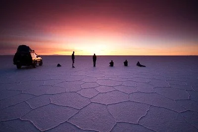
Though the seeing the dry, white salt stretch for miles is beautiful, when the salt flat is filled with water, it creates a clear mirror-like lake. Generally, there are only a few centimeters of water so it is still possible to walk on it, but as the weather is unpredictable, some areas become restricted for safety. The salt flat is mostly waterproof, but too much rain will melt some of the salt and make it dangerous to walk on. However, during this time, Salar de Uyuni turns into the world’s largest natural mirror, reflecting the light from the sky. The winter months also have clear skies that offer beautiful stargazing opportunities, the reflected stars only adding to the salt flat’s wonder.
The Salar de Uyuni is large enough to be seen from space, and it contains 10 billion tonnes of salt. 70% of the lithium in the world is also mined from this salt flat. The Salar de Uyuni was created 40,000 years ago, after Lake Michin evaporated. Over the course of its slow evaporation, the salt hardened and created a crust that formed the area into what it is today. In addition, there is still water underneath the salt that continues to evaporate as temperatures rise, which adds more salt to the surface.
Beyond the scientific explanation for the Salar de Uyuni’s creation, the locals have passed on their own legends. In one of them, one of the nearby mountain goddesses, Yana Pollera, gave birth to a baby that two other mountain gods fought over. They both believed themselves to be the father, and Yana Pollera sent her child away to where the salt flat is located today and flooded the area with her milk that eventually evaporated into salt so it would survive. Another legend claims the flat was formed because after two mountain gods were married, the husband left and the wife cried until her tears created the Salar de Uyuni.
Dawn at Salar de Uyuni. Trevor McKinnon CC BY-NC-SA 2.0.
Because of its location, there are many tours leaving from Bolivia and Chile, and many of them stretch over the course of multiple days in order to get the most out of the natural beauty. Planes, buses and trains are all able to get to Uyuni, the town closest to the salt flat, but there are also tours from Tupiza, a town south of Uyuni, and San Pedro de Atacama, a town in Chile.
RELATEAD CONTENT
Katherine Lim
Katherine Lim is an undergraduate student at Vassar College studying English literature and Italian. She loves both reading and writing, and she hopes to pursue both in the future. With a passion for travel and nature, she wants to experience more of the world and everything it has to offer.
6 of the Most Colorful Wonders of the Natural World
From the Rainbow Mountains of Peru to the Kawah Ijen Volcano in Indonesia, discover these six most colorful natural wonders of the world in Iran, Mexico, China and more.
Read MoreDiscover Cambodia’s Beauty Despite Dark Political Past
Though still recovering from Pol Pot’s regime, Cambodia contains numerous sites and monuments worth traveling for.
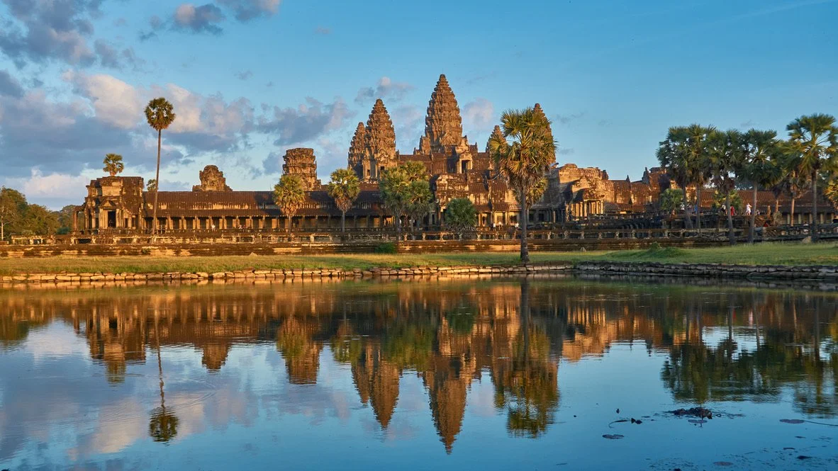
Angkor Wat Reflection. Radek Kucharski. CC BY2.0.
Cambodia is known for its massive and brilliantly crafted religious temples, vast untouched forests and vibrant city life. What some may not know is Cambodians have and are still recovering socially, economically and politically from one of recent history's most horrific events: the reign of the Khmer Rouge.
Under the rule of dictator Pol Pot, the Khmer Rouge was a Marxist regime created in 1975. Whether from execution, starvation, exhaustion and disease, more than 2 million civilians died during the genocide. Despite the defeat of the Khmer Rouge on January 7, 1979 by the Vietnamese military, Cambodians struggled to regain their political and economic prosperity. General poverty rates have lingered around 35% which is a great improvement from the 50% at the initial end of the events. Those who experienced the genocide are now be in their 50s, and thus Cambodians are still living with the traumatic experiences they went through.
With that said, the Southeast Asian country has shown great perseverance and progress towards a bright future. Now, Cambodian citizens celebrate their traditional cultures and welcome outsiders to experience the atmosphere and history of their country. Here are a few of the most popular spots.
1. Angkor Wat
Said to be the largest religious monument in the world, Angkor Wat is a vast Buddhist temple that touches over 400 acres of land and comprises over 1,000 buildings. Cambodia is home to this cultural wonder of the world and is a destination that provides both visual beauty and an introduction to Cambodia’s rich history and culture.
Angkor Wat has five lotus-like towers rising 65 meters up, being the first part of the temple visitors tend to notice. The awe-inspiring scenery continues with carvings throughout the inside of the temple. Celestial dancers, known as apsaras in Khmer (Cambodia’s national language), helped reintroduce Apsara dance in Cambodia. Carvings of war, spiritual journeys and everyday life explain Cambodia’s hardships and relationship with culture and religion. Ta Prohm, also known as the Tomb Raider Temple due to its appearance in the 2001 film, and Angkor Thom are other beautifully architected sights nearAngkor Wat.
2. Banteay Srei
Banteay in Angkor. Juan Antonio Segal. CC BY 2.0.
Known as the Temple of the Women, Banteay Srei is sacred in Angkor. Though it is much smaller in size than Angkor Wat, it contains some of Cambodia's most delicate carvings. Images of women holding lotus flowers and memorable stories of the Hindu religion are depicted here. Banteay Srei is still a place for women to visit and observe to feel inspired and appreciated, as well as a place where anyone can experience its beauty and history.
3. Bayon
Bayon Temple Ruins in Cambodia. Uwe Schwarzbach. CC BY-NC-SA 2.0.
This Buddhist Temple is home to 216 smiling, peaceful faces carved into towers. Numerous other carvings can be seen representing the experiences of the Khmer people. Bayon temple allows visitors to understand the goals and journey of the Khmer Empire and is a great temple to visit if you are interested in Buddhism and appreciating Cambodia’s past.
4. Phnom Penh
Bustling Phnom Penh. Baron Reznik. CC BY-NC-SA 2.0.
Phnom Penh is the capital of Cambodia andhome to vibrantly colored buildings, tight streets with motorbikes, friendly locals and more architectural beauty. A main mark of the Cambodian experience, Phnom Penh is affordable and easy-going—a great way to submerge yourself in the country's culture. here are some upscale restaurants and locations, but overall, Phnom Penh remains its gritty, lively and romantically chaotic self.
5. Krong Siem Reap
Angkor Wat in Krong Siem Reap. Kim Seng. CC BY-NC-ND 2.0.
Krong Siem Reap is another other major city destination in Cambodia. Krong Siem Reap is a staple of Cambodia’s religious history, being home to Angkor Wat, the ruins of Banteay Srei and Ta Prohm. Locals treat travelers as if they have been life-long friends, and travelers will get the chance to explore much of Cambodia’s Buddhist history as long as remaining respectful.
Krong Siem Reap is also known for its exquisite food scene. Cafes offer coffee, teas and delicious local food dishes with some even offering vegetarian and vegan-friendly options. Restaurants to grab an authentic and budgeted meal are around every corner.
6. Kirirom National Park
Kirirom National Park Rest Area. Arie. CC BY2.0.
Located mostly in Phnom Sruoch District, Kirirom National Park is covered with deep forestry and high elevation. Kirirom, meaning “Mountain of Joy,” is loved for its high elevation pine forests and many glistening waterfalls. Along with vast, isolated hiking trails, the endangered sun bears, pileated gibbons and tigers can be found living in the forests.
7. Koh Tonsay
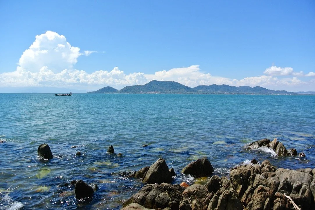
Located on the country's south coast in the Gulf of Thailand, Koh Tonsay can be translated as “Rabbit Island” and received its name because it houses the furry little creatures. It is a relatively quiet coast with a more rustic beach style. While tourists tend to visit other parts of the Cambodian coast more influenced by Chinese businesses, Koh Tonsay remains a sliver of true Cambodian land. It is not as flashy as some other beaches on the coast of Cambodia, but Koh Tonsay offers a unique and isolated beach experience.
8. Bousra Waterfall
Bousra Waterfall. Lucien Tan. CC BY-ND 2.0.
Located just outside of Sen Monorom, the Bousra (also spelled Bou Sra and Busra) waterfall is a three-level natural wonder offering viewing platforms at different heights and access to its base, where visitors can get misted and explore the powerful waters.
Haleigh Kierman
Haleigh is a student at The University of Massachusetts, Amherst. A double Journalism and Communications major with a minor in Anthropology, she is initially from Guam, but lived in a small, rural town outside of Boston most of her life. Travel and social action journalism are her two passions and she is appreciative to live in a time where writers voices are more important than ever.
VIDEO: Journey Through Thailand
This footage of Thailand serves as the second installment in Vincent Urban’s series: “In Asia.” The video features glimpses into the vibrant streets of Bangkok and the natural scenery of Northern Thailand. He also features footage from the small but lively town of Pai, located near a mountain base in Northern Thailand. The director includes evocative imagery of Buddhist temples from his visit to the city of Chiang Mai, capital of Chiang Mai province. German director Vincent Urban, based in New York City, concludes the episode teasing his next stop, Laos, for the following installment of the series.
5 Cultures That Acknowledge More Than Two Genders
A close look at these 5 cultures shows the existence of more than two genders has been part of the human experience for thousands of years.
Two-Spirit person at a march. Mia Culpa. CC BY-NC-SA 2.0.
Several societies have understood and sometimes honored genders outside of the binary for hundreds or thousands of years. The way gender is expressed differs between cultures and has been greatly influenced by globalism and colonialism. An exploration into the following five genders demonstrates the complexity of nonbinary genders and their role in society.
Two-Spirit
Two-Spirit banner at a Bay Area Pride Parade. Quinn Dombrowski. CC BY-SA 2.0.
To be Two Spirit is to contain the spirits of both the male and the female in Indigenous North American society. For one person to have both of these perspectives is regarded as a great honor and historically indicated a different role in society in terms of responsibilities and jobs. For example, Two-Spirit people were often entrusted with creating art in the Navajo Nation. While this identity has existed for hundreds of years across several Indigenous North American tribes, the title “Two-Spirit” itself was created in 1990 as an all-inclusive term for intersex, transgender and nonbinary people across Indigenous tribes.
Hijra
Hijras at a festival. Sabatica Sabata. CC BY-NC-SA 2.0.
‘Hijra’ is a third gender acknowledged in Hinduism. Hijras are often people born biologically male who dress traditionally feminine or intersex people. Regardless of their biological sex, hijra is regarded as an independent third gender. Like Two-Spirit people, hijras have a special and honored place in traditional Hindu society. They were believed to have the power to instill fertility upon couples and often live in groups to be mentored by an elder in the community. However, being hijra was criminalized by the British upon their colonization of India. Much of the way hijras are treated today as well as the opportunities available to them continue to suffer as a result of British oppression. For example, hijras are often still denied work today.
Māhū
Scholar Hinaleimoana Wong-Kalu. University of Hawai‘i–West O‘ahu. CC BY-ND 2.0
The Hawaiian māhū are people who are understood to have aspects of both genders within them. When Europeans arrived in Hawaii, they took the term and gave it a derogatory and homophobic and transphobic meaning. The term still carries a negative association for some because of the impact of colonialism. However, prior to European arrival, and still among many in the community today, māhū means “in the middle” (of male and female) and is regarded in traditional Hawaiian culture as a meaningful identity indicating a wealth of wisdom and knowledge.
Muxes
Muxe. Arnaud B. CC BY-SA 2.0.
Muxe is a gender that exists in Oaxaca, Mexico, in the Zapotec community. Muxes have a strong tie to Zapotec tradition, as they continue to practice certain Zapotec customs that most no longer take part in, such as dressing traditionally. Muxes are generally people assigned male at birth who present traditionally feminine, but muxe is considered a third gender as opposed to a transgender woman. Like Two-Spirit and hijra people, muxes play a distinct role in Zapotec society, different from those who identify with their assigned sex at birth.
Six Genders of Classical Judaism
Talmud. Chajm Guski. CC BY-SA 2.0.
The ‘Talmud’ is a book of the ancient teachings of various rabbis and Jewish religious scholars. While it isn’t a holy book itself, it contains valuable interpretations of the Torah still referenced today. The Talmud acknowledges six genders as opposed to two. The Talmud is thousands of years old, demonstrating that the idea of gender fluidity has existed for much longer than most people would think. “Zachar” and “Nekevah” translate roughly to “male” and “female” respectively, and they refer to people who grow up resembling the sex they were identified as at birth. “Androgynos” was a term used for someone with both male and female characteristics, while “Tumtum” was a term used for someone who seems to present neither male nor female characteristics. “Ay’lonit” and “Saris” are used to describe people who were assigned female or male at birth (respectively) but grow up to resemble the opposite gender. All of these terms are parallel to identities common today, suggesting that people who do not fit into the gender binary have existed throughout human history.
Calliana Leff
Calliana is currently an undergraduate student at Boston University majoring in English and minoring in psychology. She is passionate about sustainability and traveling in an ethical and respectful way. She hopes to continue her writing career and see more of the world after she graduates.
VIDEO: Experience Southeast Asia
In his trailer for “In Asia,” German director Vincent Urban highlights memorable experiences in his trip to Southeast Asia. Over two months, Urban traveled to Thailand, Cambodia, Malaysia and Laos. We are transported to Bangkok, the capital of Thailand, a city with night skies full of fireworks and streets teeming with music. Urban next introduces us to the Southeast Asian landscapes he encounters. He highlights the tropical climates of Thailand, Cambodia, Malaysia and Laos with footage of waterfalls, aquamarine waters, beaches and coral reefs. Urban also highlights Buddhist culture by featuring images of the Angkor Wat temple in Cambodia, the largest temple complex in the world. The individual episodes of “In Asia” provide greater context for the footage within this trailer and are certainly worth viewing if you would like to learn more about Thai, Cambodian, Malaysian and Laotian cultures.
Like so many others across the country, this village in Ethiopia’s Omo Valley blends seamlessly into its colorful surroundings. Rod Waddington. CC BY-SA 2.0
Top 5 Sites to Visit in Ethiopia, Africa’s Hidden Gem
Boasting a stunningly diverse landscape, a rich culture and nine UNESCO World Heritage Sites, Ethiopia belongs on every traveler’s bucket list. As word gets out, more and more visitors are discovering – and falling in love with – the East African country’s seemingly endless charms.
Seen from above, the Church of Saint George looks impressive. From below, it’s simply unreal. Bryan_T. CC BY-ND 2.0
Lalibela
Painstakingly chiseled out of rock in the 13th century, the 11 churches of Lalibela stand as powerful symbols of Ethiopia’s devotion to Christianity. After Jerusalem’s fall to Islamic conquest, King Lalibela ordered construction of a “New Jerusalem” in his own land. The results are spectacular: the Church of Saint George rests in the shape of a cross, seemingly inaccessible due to its position below ground. It’s nearly incomprehensible that the churches of Lalibela were carved out by hand 800 years ago. You may come to believe, as many locals do, that angels alone could have built such a masterpiece.
The Simien Mountains, often known as the “Water Tower of Africa,” are one of the top contributors to the Nile River. Thomas Maluck. CC BY-ND 2.0
Simien Mountains National Park
Known as the “Roof of Africa,” the Simien Mountains present a landscape of sheer cliffs, winding canyons and peaks once described by Homer as the “chess set of the gods.” Few places in Africa offer such breathtaking scenery; however, travel here takes some work. To fully experience the Simiens, prepare for long days of trekking and nights spent in remote villages. The trip may be tough, but travelers who persevere can expect jaw-dropping scenery unlike anywhere else on earth.
Eerily similar to the mazelike medinas of North Africa, Harar holds no comparisons across Ethiopia. Rod Waddington. CC BY-SA 2.0
Harar Jugol
Considered the fourth-holiest city of Islam, Harar gives off a distinct vibe from the rest of Ethiopia. Visitors head to Jugol, the fortified city, to take in the area’s maze of 368 alleyways and 48 mosques – all packed into less than a half a square mile.
Sulfur pools are one of the many anomalies that draw visitors to the harsh landscapes of the Danakil Depression. Ian Swithinbank. CC BY-ND 2.0
Danakil Depression
Lying 400 feet below sea level and recognized as one of the hottest places on earth, the Danakil Depression is downright inhospitable. Scientists flock to the region to test out whether microbes can survive the environment, believing its harshness to be about equal to that of Mars. Visitors are equally enticed by the Danakil Depression’s otherworldliness, seeking out neon-colored lakes, steaming fissures and bubbling lava patches. Travel to the area is not for the faint of heart; daytime temperatures reach up to 120 degrees Fahrenheit and the condition of the “roads” is equally hideous.
Nearly anything can be found at the Mercato, the largest open-air market in all of Africa. Jasmine Halki. CC BY 2.0
Addis Ababa
Ethiopia’s capital and largest city may not hold many star attractions, but nowhere else does the country’s culture so vividly come to life. Indulge in a cup of coffee in one of Addis Ababa’s countless cafés; this is, after all, the birthplace of the drink. Lucky visitors may receive an invite to an Ethiopian coffee ceremony, a tradition that lasts for hours and is reserved for close friends. Addis also contains some of Ethiopia’s best food. Make sure to try injera, a spongy bread filled with meat, vegetables and countless spices. Finish off the stay by visiting the Mercato, Africa’s largest open-air market. A dizzying array of gifts can be found, helping to carry the delightful essence of Ethiopia all the way home.
Stephen Kenney
Stephen is a Journalism and Political Science double major at the University of North Carolina at Chapel Hill. He enjoys sharing his passion for geography with others by writing compelling stories from across the globe. In his free time, Stephen enjoys reading, long-distance running and rooting for the Tar Heels.
VIDEO: Angkor Wat to Phnom Penh, Cambodia
Set to a mesmerizing soundtrack, this footage of Cambodia highlights the natural beauty of the country’s tropical landscape, as well as provides insight into the daily lives of its people. As viewers, we travel from surrene Angkor Wat—the world famous Buddhist temple complex—to Phnom Penh, Cambodia’s lively and bustling capital city. German director Vincent Urban, who is from Munich now based in New York City, concludes the episode teasing his next stop, Thailand, for the following installment of his series: “In Asia.”
9 Vibrant Towns Across The Globe
Vibrantly colored cities are rarely seen aside from children’s books. However, these 9 cities turn ordinary streets into colorful towns.
Vibrant town of Burano, Italy. ShortShot. CC BY-NC-SA 2.0
Color awakens visual senses and influences mood. Studies have revealed that viewing specific colors can cause feelings of excitement, sadness or joy. Moreover, colorful cities are seeing more economic growth due to the visitors they attract. People are captivated by the rarity of colorful towns, which is caused by the takeover of modern, neutral design in most urban areas.
1. Procida, Italy
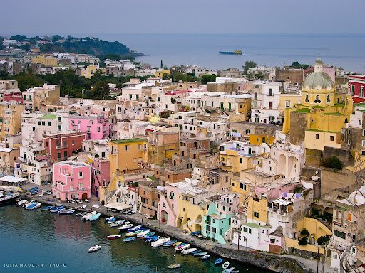
Island Town- Procida, Italy. Juliamaudlin. CC BY 2.0
This island, just off the coast of Naples, is the smallest in the Gulf and is home to a spectrum of colorful buildings. Procida is surrounded by volcanic mountains and has an estimated population of 10,300 inhabitants. Beating out nine other candidates for the title, Procida is the first island to be named Italy’s Capital of Culture, receiving the honor for 2022.
2. Copenhagen, Denmark
The harbour in Nyhavn, Copenhagen was built by Swedish prisoners between 1670-1673 and worked as a maritime port for three centuries. Lined on both sides with colorful eighteenth-century townhouses, the Nyhavn harbour is now filled with high-end restaurants, bars and shops.
3. Chefchaouen, Morocco
Often referred to as the Blue Pearl of Morocco, this predominantly blue town is located in the Rif mountains. Some say the town received its blue color as an ode to the Mediterranean Sea, while others believe the color blue represents the Ras el-Maa Waterfall. Residents maintain the blue hues by painting the town twice a year for upkeep and once before Ramadan.
4. Buenos Aires, Argentina
Streets of La Boca in Buenos Aires, Argentina. Alessandro Grussu. CC BY-NC-SA 2.0
La Boca is known for its brightly-painted houses and the performers who inhabit the colorful streets at night. The houses were painted in the 1960s by a local artist, Benito Quinquela Martín, who painted an abandoned street with bright colors. The rest of the neighborhood decided to paint as well, and they have become a tourist attraction for Buenos Aires.
5. Izamal, Mexico
“Yellow City” - Izamal, Mexico. Adachphoto. CC BY-SA 2.0
Nicknamed the “Yellow City,” Izamal is a small town in the state of Yucatan. Founded by the Mayans nearly 2,000 years ago, it is believed that the town is named after the ancient Mayan god Itzamna. This yellow city holds the largest Mayan ruin remaining in Izamal, Kinich Kak Moo.
6. Willemstad, Curacao
Colorful Coastal Town - Willemstad, Curacao. Jessica Bee. CC BY 2.0
The Kingdom of the Netherlands is made up of four countries: Aruba, St Maarten, the Netherlands and the island of Curacao. The wide range in brightly-colored homes is the result of former governor Albert Kikkert complaining of headaches. The belief among locals is that in 1817, Kikkert had all the buildings painted in bright colors because the sun’s glare caused him headaches. Willemstad is currently on the UNESCO World Heritage List to be protected and enjoyed by present and future visitors.
7. Bo-Kaap, South Africa
Neighborhood Full of Color- Bo-Kaap, South Africa. Berniedup. CC BY-SA 2.0
The colorful houses in Bo-Kaap, once known as the Malay Quarter, date back to the 1760s. They were built and leased to slaves who came from Malaysia, Indonesia and other parts of Africa to work. There came a point when the slaves were able to own the property and, in celebration, they painted the buildings in different colors. This expression of joy and freedom turned the brightly-colored neighborhood into a tourist attraction today.
8. Guanajuato, Mexico
A UNESCO Heritage Site, Guanajuato houses colorful multilayered hilltop homes. Built in the baroque and neoclassical style, the colorful town’s main attraction is Cathedral Basilica Nuestra Señora de Guanajuato. Painted entirely yellow with a stark red roof, construction began on the Cathedral in 1760 and finished a little over 100 years later in 1864.
9. Jodhpur, India
Blue Houses of Jodhpur, India. Camwears. CC BY-NC 2.0
Although a continent away, the houses of Jodhpur resemble those in Chefchaouen, Morocco for their blue hues. These houses sit on the edge of the Thar desert in northwestern India. Locals say that in the past, the priestly caste of the Brahmin community painted their houses blue to differentiate themselves from other castes. Since then, the color blue has been linked to the Brahmin people. Mehrangarh Fort offers an elevated view of Jodhpur, providing visitors the opportunity for a bird’s-eye view of the blue.
Jennifer Sung
Jennifer is a Communications Studies graduate based in Los Angeles. She grew up traveling with her dad and that is where her love for travel stems from. You can find her serving the community at her church, Fearless LA or planning her next trip overseas. She hopes to be involved in international humanitarian work one day.
The 5 Blue Zone Regions and their Centenarian Lifestyle
Dan Buettner coined the term blue zones—regions around the world where people live the healthiest and the longest. These Centenarians share similar lifestyles, although living thousands of miles from each other.
Old Man Looking Out. NeilsPhotography. CC BY 2.0
Average life expectancy around the world is 77 years. However, award winning journalist and New York Times bestselling author Dan Buettner discovered five regions where people typically live to be over 90. Buettner named these cities ‘Blue Zones’ to identify them by their life expectancy. Researchers found that although their lifestyles change slightly, the people of blue zone areas were living longer and had more fulfilled lives compared to the rest of the world. This is due to their primarily plant-based diet, their spirituality, family and social networks, along with regular exercise and drinking moderate amounts of alcohol. The five cities classified as blue zones are Okinawa, Japan; Sardinia, Italy; Nicoya, Costa Rica; Ikaria, Greece; Loma Linda, California.
1. Okinawa, Japan
Okinawan on a Walk. Dshack. CC BY-NC 2.0
Okinawans are among the healthiest living people in the world and Okinawan women live the longest in all the earth, with an average lifespan of 90 years. They follow a plant based diet, eating mostly sweet potatoes, rice, grains and soy. The Okinawan household does not have much furniture; meals are eaten on tatami mats on the floor. By getting up and down several times a day to relax or eat their meals, older people are able to gain lower body strength and, in turn, protect themselves from having dangerous falls. In addition, their diet and active lifestyle of gardening and walking everywhere helps their body stay strong. Their physical and mental welfare is accompanied by a social network called Moai. This social network consists of lifelong friends who support each other emotionally and financially in times of need. Okinawans know that there are always friends who surround them and are willing to lend support in time of need. By these simple lifestyle habits, the people of Okinawa have been able to live centenarian lives with less illness than those in other regions.
3. Sardinia, Italy
Italian Elderly Woman Going on a Bike Ride. Paolo Margari. CC BY-NC-ND 2.0
The Sardinian lifestyle has been culturally isolated from the rest of Italy as it is an island town. Sardinians' long life is the benefit of living within strong healthy families and a plant based diet accented with meat. Sardinian seniors are often surrounded by children and grandchildren, which results in lower rates of stress, depression and suicide. Men in this blue zone region are known for gathering in the street in the afternoons to share laughs with one another. Laughter reduces stress, which can lower one’s risk of cardiovascular disease. In addition to being surrounded with family and laughter, Sardinians still hunt, fish and harvest everything they eat. Their diet consists mainly of whole grain bread, fruits, beans and garden vegetables. An average of two glasses of wine daily are consumed by Sardinian residents, which is known to reduce stress among men. Meat is reserved for Sunday family meals and other special occasions. Although diet and family network help add years to Sardinians’ lives, a research team discovered that there is a rare genetic quirk carried by the island’s inhabitants.The M26 marker is linked to exceptional longevity, and due to geographic isolation, the genes of the residents in this area of Sardinia have remained mostly undiluted, resulting in nearly 10 times more centenarians per capita than the United States.
4. Nicoya, Costa Rica
The Central American nation of Costa Rica is home to Nicoya, an 80- mile peninsula just south of the Nicaraguan border. The people of Nicoya believe in having a sense of purpose for everyday living. This purpose encourages them to feel needed and want to contribute to a greater good. With the purpose driven life they live, they continue to work and find joy in their physical chores. Usually, they are surrounded with family and frequent social gatherings from friends and neighbors. Nicoya centenarians regularly take in the sun. This helps their bodies produce Vitamin D which is known to keep bones strong and contributes to a healthy body function. Their Mesoamerican diet consists of corn, squash and beans. These foods are rich in vitamins, proteins, fiber and healthy fats,creating a complete, nutritional diet that has helped Nicoya people live well into their 100s.
4. Ikaria, Greece
Greek Man Smiling. Julie70. CC BY-NC-ND 2.0
The small island of Ikaria in Greece sits on the Aegean Sea and is home to an almost dementia-free society. Lifestyle, clean air, relaxed pace and diet contribute to the longevity of Ikarians, with one in three making it to their 90s. The people of Ikaria tend to relax mindlessly through gardening, walking to a neighbor's house or playing late night domino games. Through the games and socializing, Ikarians are able to create connections with others. Studies have found that having a strong social network is part of living a healthy life. Their faith also aids in their longevity, as most Ikarians are Greek Orthodox Christians. While practicing calls for fasting almost half of the year, it cuts about 30 percent of calories out of the normal diet — the only proven way to slow the aging process in mammals. Lastly, almost all Ikarians drink goat milk as it provides potassium and the stress-relieving hormone tryptophan.
5. Loma Linda, California
"Loma Linda, California. CCPIX. CC BY-NC 2.0
A community of an estimated 9,000 Adventists who live in Loma Linda, California put the US on the blue zone list. Adventists live 10 years longer than other Americans. Their beliefs, their volunteering, diet, exercise and fellowship add years to their lives. The Seventh-day Adventist Church encourages and provides opportunities for its members to volunteer. Through volunteering, many are able to focus on others and this allows Adventists to ward off depression. Their well balanced diet of vegetables, fruits, legumes and lots of nuts is influenced by the Bible. Adventists cite Genesis 1:29: “And God said, Behold, I have given you every herb bearing seed, which is upon the face of all the earth, and every tree, in which is the fruit of a tree yielding seed; to you it shall be for meat.” They also avoid smoking and drinking, a healthy habit that will help prevent future health issues. Many Adventists go on daily walks or participate in low intensity exercise. Their active bodies can stay consistently strong. Adventists’ time spent with like minded people who support their habits is what continues to make them some of the longest living Americans.
Jennifer Sung
Jennifer is a Communications Studies graduate based in Los Angeles. She grew up traveling with her dad and that is where her love for travel stems from. You can find her serving the community at her church, Fearless LA or planning her next trip overseas. She hopes to be involved in international humanitarian work one day.
The Smallest Country in South America: Suriname
The nation of Suriname is home to a multicultural society and the Amazon rainforest. Yet, little is known of the country as it attempts to stand out behind the shadows of its former Dutch colony.
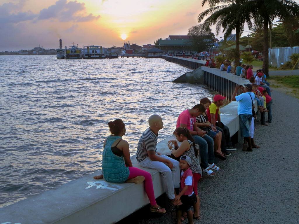
Suriname River Waterfront. D-Stanley. CC BY 2.0
When one thinks of South America, one thinks of all the Spanish-speaking countries. However, rarely do you think of The Guianas, the three countries in the northern part of the continent: Guyana, Suriname and French Guiana. The smallest nation of the three is Suriname, and it covers a surface area of 63,252 square miles. Known as a former colony of The Netherlands, Suriname gained its independence in 1975. This Dutch-speaking nation is surrounded by 94% of pristine forest and has a multicultural society.
Suriname is named after its first occupants, the Surinen Indians. However, in 1602 the Dutch settled in the region, and by 1667 it became a colony of the Netherlands. Throughout the Dutch’s settlement in the nation, many important events made Suriname the country it is today. After the termination of slavery, the Dutch brought in East Indian laborers. The Netherlands granted Suriname its independence on November 25th, 1975, when the Surinamese people rioted over inflation and unemployment. Fast forward to today, the country is a constitutional democracy.
In addition, Suriname is struggling with seven in ten people falling below the poverty line. The Surinamese rely heavily on the exportation of gold and other minerals, accounting for 85% of exports and 27% of government revenues. Agriculture is also a big part of their exportation, which includes bananas, rice and shrimp. With poverty taking a toll on its people, there has been an upside to their current financial situation. The country will begin producing oil in 2025, appealing to prospective investors. The government holds 13 billion barrels of oil and gas that have been discovered in the past six years. With this finding, financial stability can emerge for the Surinamese. At the moment, Suriname produces oil for domestic use and its own oil company Staatsolie.
Surinam youth. KITLV Collections. CC BY-NC 2.0
With the history Suriname has lived through, it is no surprise that it is a multicultural nation. It is made up of South Asians (Indians), Maroons, Suriname Creole(Afro-Surinamese), Javanese, biracial and others.
Even ith this diverse and integrated culture that makes up Suriname, citizens of this nation live peacefully among one another. So much so that a Jewish temple and a Muslim mosque sit side by side in the capital city of Paramaribo. This cohabitation can be seen as the entire country officially marks other nations’ religious and nonreligious holidays as their own. . These holidays include Chinese New Year, Easter, Indigenious Peoples Day, Maroons day, Idul Adha and Deepavali. Through this act, the nation exemplifies unity through its melting pot of diversity.
With any diverse culture comes an eccentric music genre. Through the music, one can hear the different backgrounds of each region represented. Suriname’s music style is no different. It is a mixture of International European, North American indigenous and South American rhythms. One of the Surinamese most well-known music forms is Kaseko. It is a fast-paced beat with Indo-Caribbean influence, which emphasizes wind instruments and percussion.
The nation’s cuisine is quite diverse as well and is a big part of the Surinamese culture. However, there is a dish that they call their own, which is Pom, the National dish. The name Pom is short for pomtajer, the root vegetable used to top the dish. Pom is a casserole made up of root vegetables and your choice of meat. This dish is a luxury, usually served on special occasions due to the high cost of meat.
Muslim Temple and Jewish Mosque sitting side by side. Dan Lundberg. CC BY-SA 2.0
There are many influences in the country’s buildings and architecture today. With all of the ethnicities and cultures that inhabit Suriname, it is no surprise it would spill over onto the design of the city. Made up of mostly wooden buildings, the style and design seem to have stayed rooted in a specific time period. There are no contemporary buildings, and that is what makes the city so enchanting. Throughout Suriname you can see the fusion of Dutch, North American and Creole culture and others in the architectural style.
On the outskirts of the city sits more than 90% of lush green forest, the Amazon. With such vast greenery, this forest is home to 150 species of mammals, 650 bird species and 350 fish species. With such a large part of the forest being untouched and preserved, Suriname species don’t face extinction like other species around the world. This is due to the capacity of the land makes it easy to house the numerous species. Nature enthusiasts visit the various nature reserves Suriname has to offer. The largest and most popular is the Central Suriname Nature Reserve at 1.6 million hectares; it protects the upper watershed of the mighty Coppename River and other important rivers. The reserve’s animals include sloths, jaguar, tapir, eight species of primates and others.
Sunset in the Suriname rainforest. Delphinidaesy. CC BY-NC-ND 2.0
This small nation is home to slightly fewer than 600,000 people. Although mostly unknown to many, Suriname is slowly bringing in many travelers worldwide. Its unique landscape and culture are admired and it is sure to attract many more travelers in the years to come. Suriname is making a name for itself on the world map with so many species to see and nature reserves to explore.
RELATED CONTENT:
Jennifer Sung
Jennifer is a Communications Studies graduate based in Los Angeles. She grew up traveling with her dad and that is where her love for travel stems from. You can find her serving the community at her church, Fearless LA or planning her next trip overseas. She hopes to be involved in international humanitarian work one day.
5 Famous Japanese Flowers and Their Cultural Significance
Japan is home to many incredible feats of nature, but arguably one of the most beautiful parts of Japan’s landscape is its flowers—many of which can only be found in Japan.
Sakura and Mt. Fuji. Skyseeker. CC BY 2.0.
Flowers are national symbols of Japan. They represent specific emotions or sentiments and are often given as gifts to express unspoken feelings. In Japan, flowers communicate emotions in place of words; the Japanese “say it with flowers.” The Japanese proverb, “Iwanu ga hana 言わぬが花,” literally translates as “not speaking is the flower.” It means that some things are better left unsaid. This language of flowers is called “Hanakotoba,” with each flower conveying a very specific meaning and sentiment in Japanese culture. This tradition stems from Japan’s strong ties to Buddhism, which teaches the value of appreciating the present moment and connecting with nature. Below are five famous and culturally important Japanese flowers.
Lacecap Hydrangea. Ali Eminov. CC BY-NC 2.0.
1. Lacecap Hydrangea
Hydrangea macrophylla is a species of flower in the Hydrangeaceae family, native to Japan. There are many components to this plant, but they all come together to form one beautiful flower. The flowers are white and purple with four wide petals and small blue bulbs in the center—a feature of regular hydrangeas. In the middle of these flowers is a bunch of smaller blooms in shades of blue, purple and green. The flowers on the outside grow into large petals, while the bunch in the center remains as smaller flowers and buds. The Japanese name for this flower is Gaku, meaning “frame,” and representing the formation of the flower. In Hanakotoba, hydrangeas represent pride; this flower is gifted to someone the giver is proud of.
A red-veined cardiocrinum cordatum flower. Peganum. CC BY-SA 2.0.
2. Cardiocrinum cordatum
Cardiocrinum cordatum is a species of flowers in the lily family that is native to Japan and specific Russian islands. This flower resembles a lily, but its leaves are different in that they are shaped like a heart. The pale green flower blooms to the side, and is often used ornamentally due to its large, showy leaves. In Hanakotoba, white lilies represent purity and chastity.
Ranunculus japonicus flowers. Greg Peterson. CC BY-NC-SA 2.0.
3. Ranunculus japonicus
Also known as the Japanese Buttercup, this flower is a perennial from the family Ranunculaceae and is of Chinese and Japanese origin. Mainly growing in mountains and fields from Hokkaido to Okinawa, the Japanese Buttercup is an abundant, wild grass. In terms of appearance, these flowers are a bright yellow, with five rounded petals and a ring of yellow fringe around the small green bulbs in the center. According to the Japanese meaning, its leaves resemble horse hoofprints in the grass. Although very small, these flowers are bright and bring happiness to those who see them.
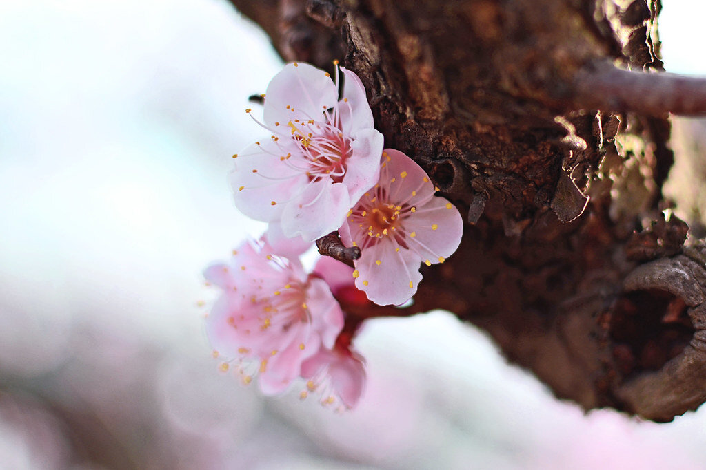
Japanese Apricot (Plum Blossom). Toshihiro Gamo. CC BY-NC-ND 2.0.
4. Prunus mume
Also known as Ume or Japanese apricot, these blossoms are from an East Asian and Southeast Asian tree species in the Armeniaca section of the genus Prunus (plums). They grow on the branches of the Japanese apricot tree and are incredibly fragrant with the smell of sweet honey. These flowers are also edible and make for stunning houseplants with their beautiful color and texture. The blossom’s buds are a dark pink, but they eventually bloom into a light pink when fully grown. In Japanese culture, this plant represents elegance, faithfulness and pure heart.
Camellia sasanqua, a November treat. Vicki DeLoach. CC BY-NC-ND 2.0.
5. Camellia sasanqua
Sasanqua is a species of Camellia native to both China and Japan, although it mostly grows in southern Shikoku, Kyushu and farther islands such as Okinawa. These bright pink and red flowers wilt one petal at a time, blooming from the end of autumn into the winter. In Hanakotoba, these flowers signify being in love or perishing with grace. Symbolizing the union between two lovers in the Chinese meaning, the delicate camellia petals represent the woman while the green leaves on the stem represent the man who protects her. The two components join together, even after death.
RELATED CONTENT:
VIDEO: Savor Japan’s Deep-Fried Maple Leaves
VIDEO: Bloom: Japan
VIDEO: Enter Kenya’s Rose Oasis
Isabelle Durso
Isabelle is an undergraduate student at Boston University currently on campus in Boston. She is double majoring in Journalism and Film & Television, and she is interested in being a travel writer and writing human-interest stories around the world. Isabelle loves to explore and experience new cultures, and she hopes to share other people's stories through her writing. In the future, she intends to keep writing journalistic articles as well as creative screenplays.
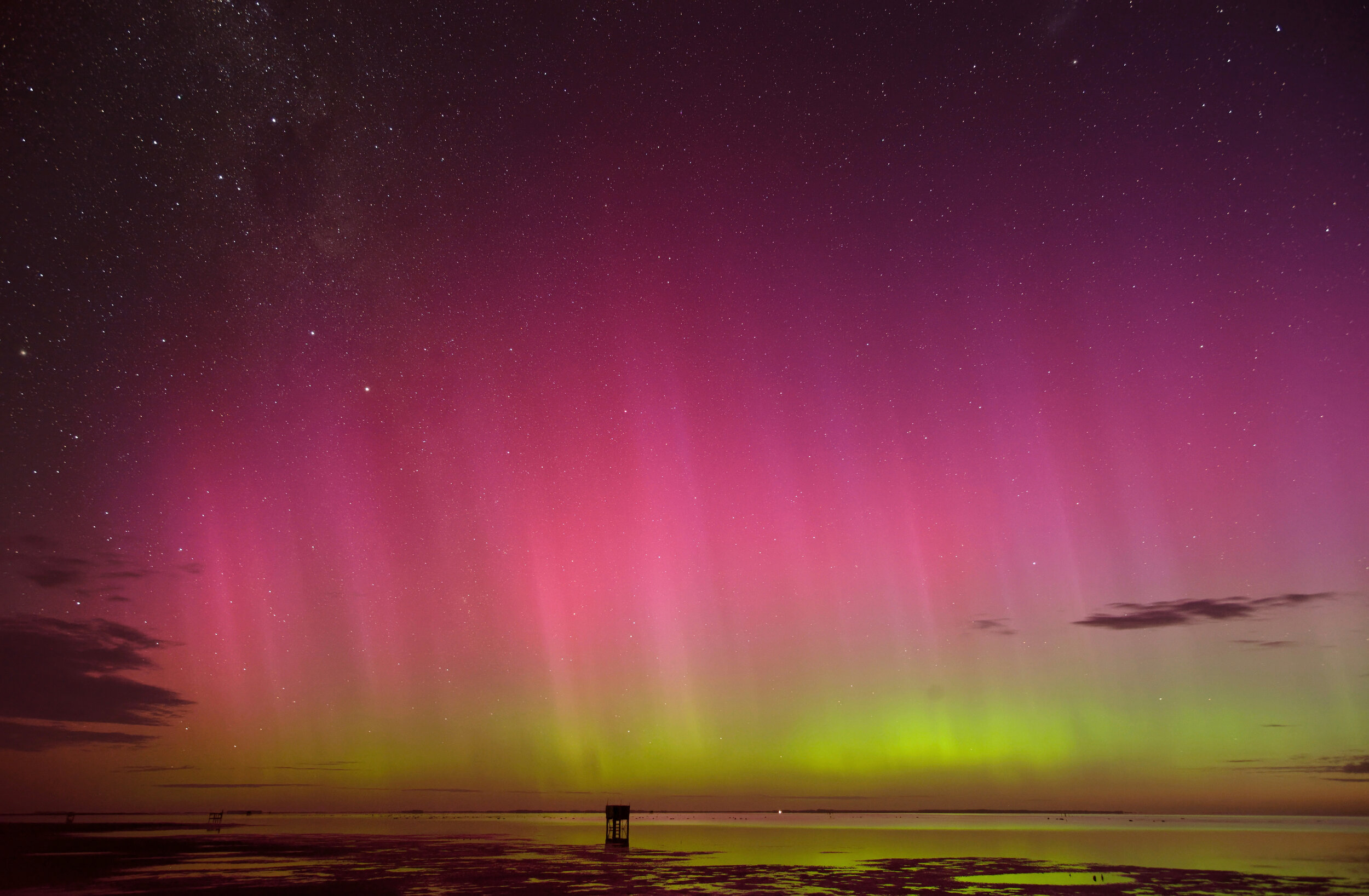
The aurora australis, seen from Lake Ellesmere, New Zealand. Ben. CC BY-ND 2.0.
Get Lost in the Dazzling Southern Lights of the Aurora Australis
One of the most beautiful parts of living near either of the global poles are the auroras. The stunning natural light shows, which are caused by solar winds creating disturbances in the magnetosphere, light up the skies of most planets and natural satellites in our solar system. On Earth, when people speak of the auroras, they most commonly are referring to the aurora borealis, or the northern lights. While the northern polar regions are more populous than those in the south, the northern lights’ counterpart, the aurora australis, provides an equally immaculate light show.
Commonly viewed throughout high southern latitudes in Antarctica, Argentina, Chile, Australia and New Zealand, the aurora australis changes colors depending on the altitude and chemistry of the disturbances caused by solar winds. The signature green color most commonly associated with auroras occurs when particles carried by solar winds collide with oxygen molecules at lower altitudes. However, other colors like red only occur at higher altitudes.
The aurora australis, as seen over the Indian Ocean from space. NASA Johnson. CC BY-NC-ND 2.0.
In general, auroras of all types occur during their respective hemisphere’s winter. The northern lights commonly occurs from December through April, while the aurora australis generally appears from March through September. However, there is no guarantee that the lights will be visible even in the most optimal conditions given the variability of the colors which form and the light pollution in more populated viewing areas. The closer one is to a magnetic pole, however, the better the chance they have of viewing the natural light show.
While the aurora australis may be a bit more difficult to view than its northern counterpart, there are several popular areas in the Southern Hemisphere commonly visited by travelers looking to experience auroras for themselves.
In South America, the most common region for viewing is Patagonia, which encompasses the southernmost tip of the continent and is shared by Chile and Argentina. The region is home to Punta Arenas, Chile, the largest city in the world below the 46th parallel, and a number of parks which are home to penguins, glaciers and fjords. Due to Patagonia’s low population, light pollution generally does not interfere with viewing the aurora australis.
The aurora australis viewed over Hobart, Tasmania. Andrew Wallace. CC BY-NC-ND 2.0.
Off the coast of South America are the Falkland Islands and South Georgia Island. Both British Overseas Territories, these two areas are perfect for viewing the aurora australis given their respective sub-Antarctic and polar climates along with low populations. Visitors to these islands can also get up close and personal with penguins, and get a taste of the Antarctic climate.
In the Eastern Hemisphere, two islands in Oceania are most commonly associated with the aurora australis. The most populous of the two, the Australian island of Tasmania, is a popular tourist destination outside of being an optimal viewing point for the aurora australis. The island, which is home to a variety of unique flora and fauna unseen anywhere else in the world, is a popular destination for Australians living on the mainland. Here, the aurora australis is best viewed in the island’s southernmost regions like Southwest National Park and Bruny Island.
Further to the east is Stewart Island, the third-largest island in New Zealand. Located in the far south of the country, the island is such a common viewing point for the aurora australis that its native Maori name, Rakiura, translates to “the land of glowing skies.” Given how remote the island is and how few people live there, simply being on the island is the best optimal viewing point for the natural light show.
The aurora australis provides a truly once-in-a-lifetime experience which is best enjoyed in person rather than via video or imagery. The dazzling colors have struck awe into the hearts of folks for generations, and will continue to do so for generations to come.
Jacob Sutherland
Jacob is a recent graduate from the University of California San Diego where he majored in Political Science and minored in Spanish Language Studies. He previously served as the News Editor for The UCSD Guardian, and hopes to shed light on social justice issues in his work.
10 Indigenous American Historical Sites to Visit
Ten million people lived in what is now the United States before Europeans arrived. These Indigenous Americans lived in complex cultures and completed amazing architectural feats that persevere to this day.
By the time European explorers arrived in the Americas, the Western Hemisphere was already home to more than 50 million people. Ten million of these people lived in what is now the United States. These Indigenous Americans developed intricate communities, religions and lifestyles, and made a lasting impact on American history and culture. Incredible sites built by Indigenous people can be found throughout the U.S. today, including cliff dwellings, multistory stone houses, earth lodges and effigies, and other stunning ruins. The history of Indigenous people is often overlooked or swept under the rug in favor of European colonists when looking at the larger context of American history, but preserved sites teach visitors about the complex cultures that came before Western settlers. These 10 sites showcase some of the impressive architectural triumphs of Indigenous people and pass on their histories.
1. Knife River Indian Villages National Historic Site, North Dakota
Located near Stanton, North Dakota, the Knife River Indian Villages National Historic Site preserves the history of the Knife River region. The Knife River region, an area in North Dakota centered around a tributary of the Missouri River, has been home to a number of people groups for around 11,000 years. Not much is known about the cultures that have inhabited the Knife River region because very few artifacts from the area remain, but early written records document the lives of the Hidatsa people. Like the Mississippian people, the Hidatsa resided in earth lodges. The Mandan and Arikara were also earth lodge residents who settled in the Knife River region, and all three groups pioneered agriculture in the area while still hunting and gathering. Villages were the center of earth lodge peoples’ lives, and the park features the remains of three large villages constructed by the Hidatsa: Awatixa Xi’e village, Hidatsa village and Awatixa village.
2. Puu Loa Petroglyphs, Hawaii
Hawaii Volcanoes National Park, on Hawaii’s Big Island, protects Mauna Loa and Kilauea, two of the world’s most active volcanoes. It is also home to the Puu Loa petroglyphs, stone etchings that document the lives and culture of the Native Hawaiian people. The petroglyphs are located in a lava field that is at least 500 years old, and the site has over 23,000 different petroglyphs. There are a variety of geometric designs, as well as depictions of people and tools, such as canoe sails. A number of the petroglyphs contain cupules, or holes where a portion of the umbilical cord was placed after the birth of a child in order to ensure long life. The first known written account of the petroglyphs is attributed to missionary Rev. William Ellis in 1823, but some petroglyphs likely date to the 1600s or even earlier. In addition to being used to ensure long life, some petroglyphs were used to record the movements of travelers on the island. Visitors to Hawaii Volcanoes National Park can take a 1.4-mile round trip day hike on a boardwalk to admire the petroglyphs up close.
3. Mesa Verde National Park, Colorado
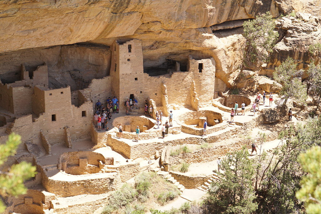
Probably one of the most well-known Indigenous sites in the United States, Mesa Verde National Park in Colorado preserves almost 5,000 historical sites of the ancestral Pueblo people, including 600 cliff dwellings. The ancestral Pueblo people lived at Mesa Verde for more than 700 years, from 550 to 1300 A.D. The first people settled at Mesa Verde in 550 A.D., turning from hunting and gathering to agriculture and building small villages of pithouses, sometimes sheltered in cliff alcoves. Around 750 A.D., these people began building houses above ground and became known as the Pueblo people, meaning “village dwellers.” The houses evolved from being made of poles and mud to being skillfully constructed from stone. Then, in 1200 A.D., for reasons that are unknown, the ancestral Pueblo began to move back into cliff alcoves and developed the cliff dwellings that make Mesa Verde famous. Mesa Verde’s cliff dwellings are truly incredible examples of Indigenous architecture, ranging from one- to 150-room houses. They are also some of the best-preserved cliff dwellings in North America, and visitors can tour some of the structures, like Balcony House and Cliff Palace.
4. Effigy Mounds National Monument, Iowa
Ceremonial mounds created by Indigenous Americans can be found across the United States. Effigy Mounds National Monument preserves more than 200 distinct mounds built by people known as the Woodland Indians and gives visitors a glimpse directly into Woodland Indian culture. The mounds, found in northeastern Iowa, are unique because a large number of them are effigies in the shape of animals. Thirty-one of the mounds are bear or bird effigies. The Woodland culture consisted of hunter-gatherers who during the summer lived in large campsites along the Mississippi River, which they relied on for food and water. Archaeologists and researchers do not know precisely why the effigy mounds were built, but they guess that they may have been made for religious rituals or burial ceremonies. Guided tours are available throughout the summer at Effigy Mounds to teach visitors more about the area’s rich history, and there are also hiking trails around the site.
5. Chumash Painted Cave State Historic Park, California
Just outside of Santa Barbara sits the Chumash Painted Cave, a room-sized sandstone cavern filled with colorful anthropomorphic and geometric figures. The exact age of the cave paintings is unknown, but archaeologists estimate that they date to the 1600s or earlier. The paintings are attributed to the Chumash, a name referring to several groups of Indigenous people who lived along the coast of Southern California and on the nearby Channel Islands. The Chumash groups spoke a variety of what linguists refer to as the Hokan language, and they constructed canoes from pine or redwood planks, which they used to sail up and down the California coast to hunt, gather and trade with other tribes. The Chumash lived in round homes known as “aps,” organized into villages. A number of archaeological sites displaying Chumash rock art have been discovered, and the Chumash Painted Cave is one of the most well preserved. The meaning behind the figures at the painted cave is unknown, but the art may be connected to Chumash astrology and cosmology.
6. Chaco Culture National Historical Park, New Mexico
A valley in the high desert of northwestern New Mexico houses an ancient, sprawling center of ancestral Pueblo culture. Between 850 and 1250 A.D., the area that is now Chaco Culture National Historical Park was the epicenter of a widespread expansion of Chacoan culture. The Chacoan people used unique masonry techniques to construct stone houses multiple stories high, some containing hundreds of large rooms. The buildings were intricately planned out and often constructed according to solar, lunar and cardinal directions, as well as to maintain clear lines of sight between houses. By 1050, Chaco was the economic and cultural center of the San Juan Basin, with people from all over the area gathering there to share knowledge and traditions and to participate in ceremonies. A number of the great houses have been preserved and can be seen today, along with petroglyphs made by the Chacoan people. Since 2013, Chaco has also been designated an International Dark Sky Park, meaning it is one of the best places in the country to get a view of the night sky untainted by light pollution. Visitors can look at the sky the same way the Chaco people saw it a millennium ago.
7. Ocmulgee Mounds National Historical Park, Georgia
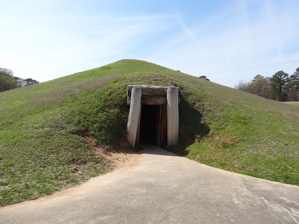
Minutes outside of downtown Macon, Georgia, lies Ocmulgee Mounds National Historical Park, a site shaped by 17 millennia of habitation, dating back to prehistoric times. The nomadic Paleo-Indian people arrived at the site in around 17,000 B.C., during the last ice age. Around 9,600 B.C. the Paleo-Indian era gave way to the Archaic era. The Early Archaic people were nomadic hunters as well, but evidence suggests that by the Middle Archaic period people began to build more permanent settlements and gather food. It wasn’t until the Mississippian people, who migrated to the area in 900 A.D., that the land was permanently changed, however. The Mississippians constructed impressive villages that literally reshaped the landscape, forming elaborate earthen lodges and temples that are still visible today. The Mississippian culture declined after the 1539 arrival of Spanish explorer Hernando de Soto, who brought with him foreign diseases that devastated the Mississippian people. Descendants of the Mississippian people, the Muscogee Creek Nation, who lived at Ocmulgee from 1600 until their forcible removal by Andrew Jackson in 1836, considered the mounds built by their ancestors to be sacred. Today, visitors to the site can see several of the mounds constructed by the Mississippian people, as well as the location of two Civil War battles.
8. Little Bighorn Battlefield National Monument, Montana
Little Bighorn Battlefield National Monument memorializes the site of the Battle of Little Bighorn, a fight between the 7th Regiment of the U.S. Cavalry and thousands of Sioux, Cheyenne and Arapaho tribe members. It lies within the Crow Indian Reservation in southeastern Montana. On June 25, 1876, the 7th Regiment, led by Lt. Gen. George Custer, attacked a village of free Lakota and Cheyenne people. The battle was part of the U.S. campaign to force Indigenous people to comply with the 1868 Treaty of Fort Laramie, which created a large reservation in South Dakota intended to house the Lakota. Many Lakota did not want to give up their nomadic lifestyle in favor of a life controlled by the U.S. government, resulting in a number of armed conflicts. The Battle of Little Bighorn proved deadly for both sides, but the Lakota and Cheyenne ultimately triumphed, defeating Custer and his troops. Though the Lakota and Cheyenne tribe members won the battle, Custer’s defeat became a rallying cry for U.S. efforts to force Indigenous people onto reservations, and stronger military forces were sent to conquer the tribes. The monument includes the battlefield itself, as well as the Custer National Cemetery and a number of hiking trails.
9. Aztec Ruins National Monument, New Mexico
Despite its name, Aztec Ruins National Monument has no association with Mexico’s Aztec empire. These large, multistory stone buildings, located within the city limits of Aztec, New Mexico, were constructed by the ancestral Pueblo. Early Western settlers thought that the site was built by the Aztecs, so they named the area “Aztec,” and the name remained even after the true builders of the ruins were discovered. Aztec Ruins was the largest ancestral Pueblo community in the Animas River valley. The site features a number of “great houses” made of stone, including the West Ruin, which had over 400 interconnected rooms. Each great house had a “great kiva,” a large, underground circular chamber used for ceremonies. Aztec Ruins also has three above-ground kivas, each encircled by three walls forming a triangle. Aztec Ruins was likely influenced by Chacoan culture, and may have even been an outlying community of Chaco. Visitors can wander through the rooms of West Ruin on a self-guided tour, or participate in ranger-led programs.
10. Hopewell Culture National Historical Park, Ohio
The term “Hopewell culture” refers not to a specific tribe, but to a “distinctive set of artifacts, earthworks and burial practices” common in areas of southern Ohio during the Middle Woodland period, from around 1 to 400 A.D. The Hopewell Mound Group is an 130-acre earthwork complex, which contains 29 burial mounds and was once enclosed by an enormous earthen wall that spanned over 2 miles and was up to 12 feet high. Remnants of the walls are still visible, as are several of the large, uniquely shaped mounds. Hopewell Culture National Historical Park encompasses five additional sites, all with fascinating remnants of the Hopewell culture. Settlements typically consisted of a few families living close together in rectangular houses with a shared garden nearby. In addition to growing domesticated plants, people of the Hopewell culture were hunters, fishers and gatherers. Visitors to the park will discover the commonalities between each distinct site by exploring the incredible Hopewell Mounds and looking at preserved artifacts.
Rachel Lynch
Rachel is a student at Sarah Lawrence College in Bronxville, NY currently taking a semester off. She plans to study Writing and Child Development. Rachel loves to travel and is inspired by the places she’s been and everywhere she wants to go. She hopes to educate people on social justice issues and the history and culture of travel destinations through her writing.

