
150 years ago, Argentina’s African population was deliberately decimated. Today, the few Afro-Argentines remaining reckon with a trau
Read MoreVIDEO: Gaza Farmers Fighting for Their Lives
The Israel-Palestine conflict has been a dire diplomatic issue for the past half century, and unfortunately the situation is not getting any better, at least for those caught in the line of fire.
The Gaza Strip has been one of the most dangerous places for Palestinians ever since Israel set up a blockade in 2005, preventing Palestinians from accessing imports and exports out of the area, or even access the outside world. Violence in the area has increased in the last few years, with incidents such as Palestinian protesters being killed by Israeli snipers, drawing the eyes of the world to the conflict.
Still, the civilians must find a way to survive each day. This video tells the story of farmers in Gaza, who have to deal with both cripplingly low wages and Israeli gunfire to make ends meet. Matthew Cassel’s filming is gripping, thought-provoking, and painfully honest, showing that even those who have no desire for conflict cannot escape its deadly consequences.
Volksprater: Austria’s Ancient Amusement Park
As the oldest functioning amusement park in the world, Vienna’s Prater Park offers rides, local foods and Austria’s largest nightclub.
Read MoreThe Long History of Ireland’s Wild Atlantic Way
The route that spans all down the west coast of Ireland has an abundance of sites that tell the story of Ireland's history, dating from ancient ruins to modern times.
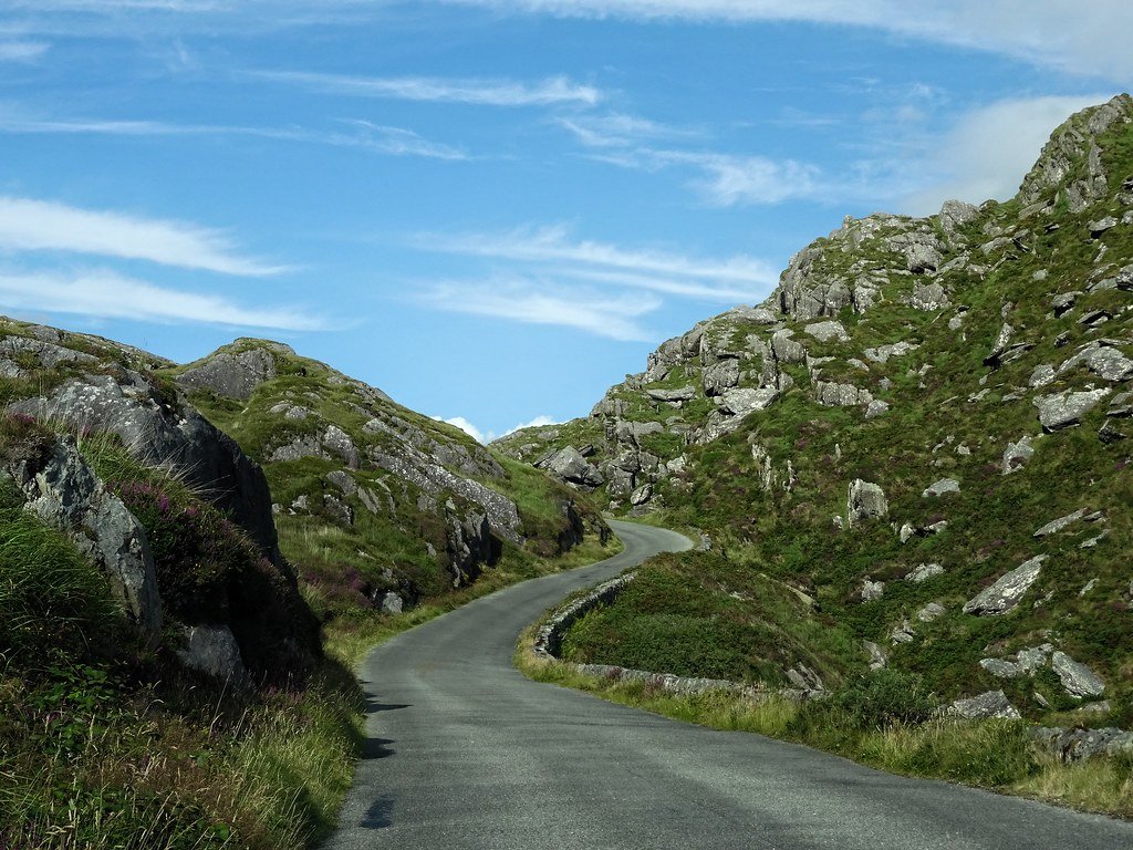
The Wild Atlantic Way, a 1,500-mile road that stretches along the Western coast of Ireland, features coastal cliffs, small towns, and a look into Ireland’s long history. The route stretches from the Peninsula in Donegal to Kinsale on the southern coast. Travelers can either drive, bike or walk along the path. Although the scenery along the route is infamous ( most notably the iconic Cliffs of Moher), the Wild Atlantic Way features more than just cliffs and rolling hills. All along the route, numerous sites illustrate Ireland’s history, dating back to ancient ruins. For example, the Grianán of Aileach, a fort dating back to 1700 BC, is still standing today. The circular fort is made of stone, with walls roughly 16 feet high. The fort’s origin is linked to Tuatha de Danann, a ruler in Ireland before the Celts invaded. The fort is positioned on Greenan Mountain in Donegal county along the Wild Atlantic Way and has views of the valleys below. By the 19th century the fort was still standing, although in poor condition. Restorations were carried out in the late 19th century, to preserve the historic site. Travelers can still visit the fort today due to the restoration that took place in the 19th century.
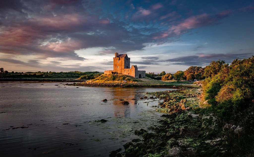
Entering the Medieval Age, the Dunguaire Castle located in Galway was built in 1520 by regional rulers at the time, the O ́ hEidhin (O’Hyne) family. In the 17th century, the castle became the property of the Martyn family and remained so until 1924. Under its new owner, the castle not only became a medieval remnant but a site for Ireland’s literary revival. The owner, Oliver St John Gogarty, a well-known literary figure, invited other writers to meet at the castle. Notable visitors included WB Yeats, George Bernard Shaw and JM Synge. The castle is now open to the public and tells a piece of Ireland’s history from late medieval times to the present.
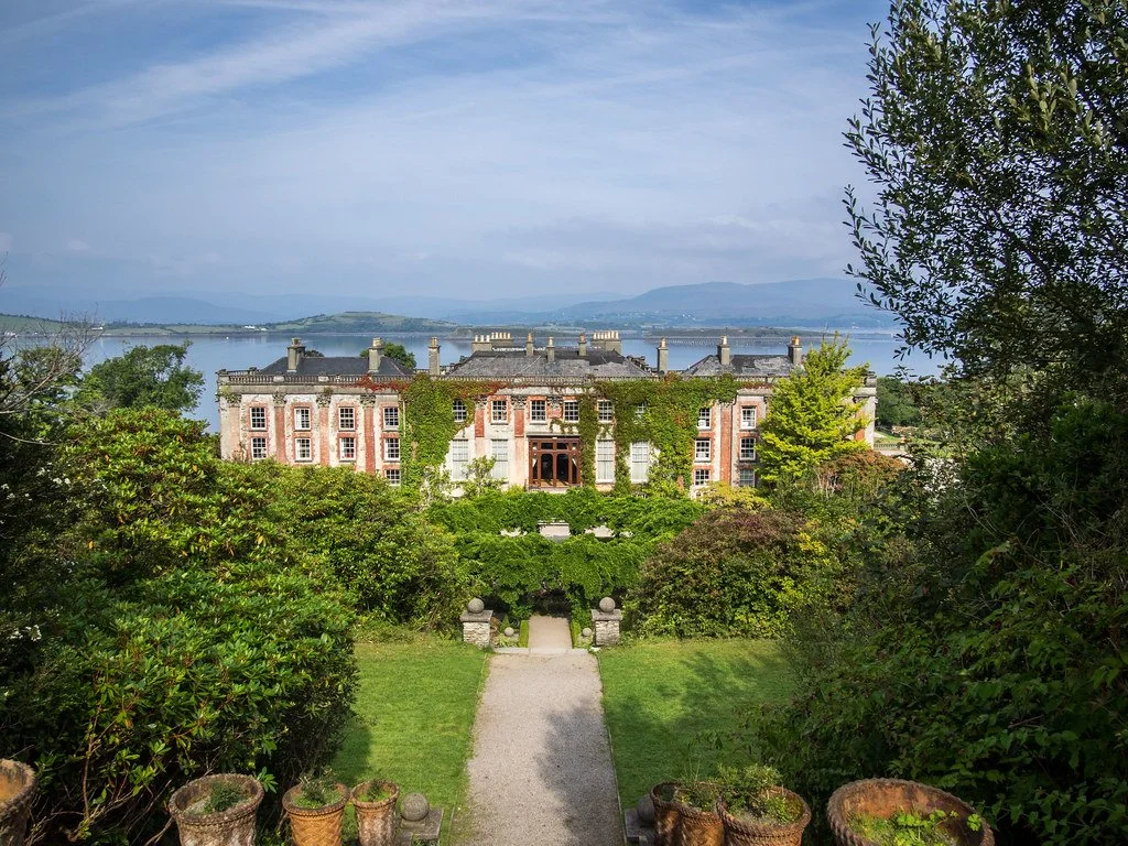
Another example of Ireland’s history is the Bantry House, originally built in the early 18th century; the house shows how Ireland’s upper class lived during turbulent times. By the mid 19th century, the White family, a prominent merchant family in Ireland, had done considerable renovations on the home to make it into the opulent house it is today. While Ireland was suffering from the great famine, the White family was rising through the ranks of society. The house was used as a hospital during the Irish Civil War in the early 20th century and later used to house soldiers during the second world war.
The Wild Atlantic way features numerous other historic sites and gives travelers a look into Ireland’s past. The route not only features historical sites but is still full of life for the present day. Small towns continue to thrive along the coast. For example: in the southern end of the route, Kinsale, once a medieval fishing town, is now known for its colorful buildings, the community of creatives who live there and their local food. The history along the Wild Atlantic way is not just in the past. Still, it has evolved with Ireland throughout its history.

Dana Flynn
Dana is a recent graduate from Tufts University with a degree in English. While at Tufts she enjoyed working on a campus literary magazine and reading as much as possible. Originally from the Pacific Northwest, she loves to explore and learn new things.
Tibetan Worship and Culture at Lhasa’s Jokhang Temple
Take a visual visit to Jokhang Temple in Tibet, one of the holiest destinations for Tibetan Buddhists, with this magnificent photo essay by Carol Foote. See traditional dress and culture on this pilgrimage route.
Read More6 Interesting Facts about the Egyptian Pyramids
There is still so much we don’t know about the history and structure of the Egyptian pyramids. Here are six things that you may not have known about the pyramids and ancient Egypt.
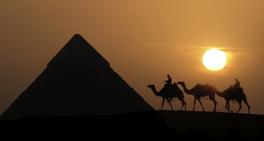
Egyptian pyramids in the sunset. Club Med UK. CC BY-NC 2.0.
The Egyptian pyramids are famous for their buried mummies and treasures, but there are still many secrets waiting to be uncovered about their history. Take a deep look into the ancient pyramids’ past with these six interesting facts.
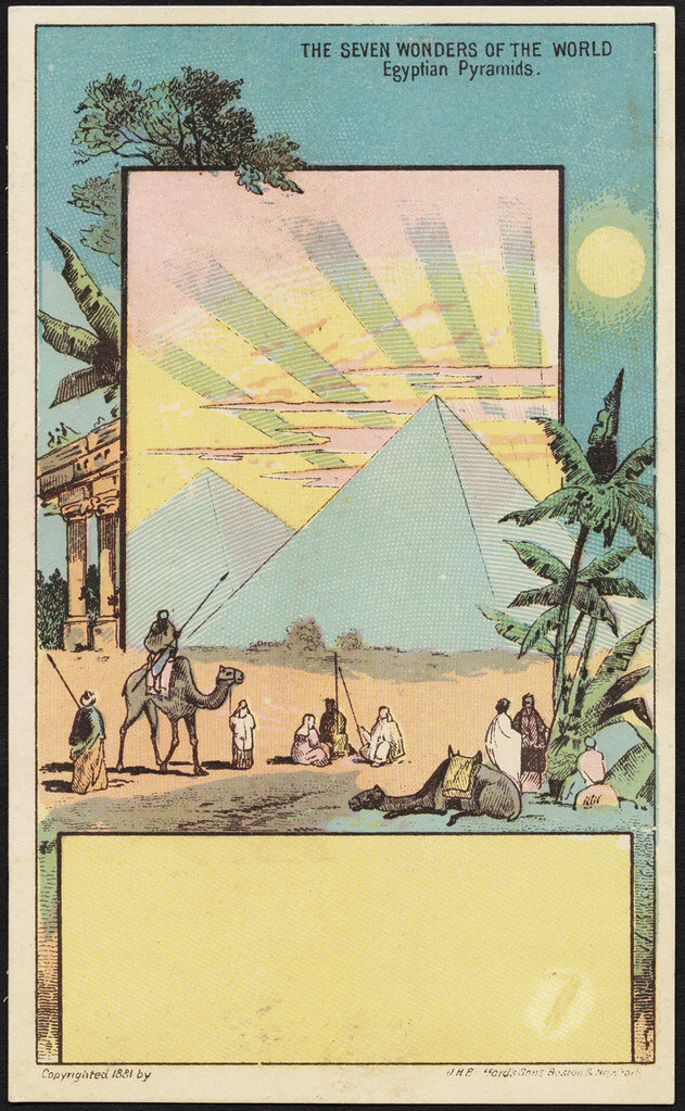
The seven wonders of the world, Egyptian pyramids. Boston Public Library. CC BY 2.0.
1. Once upon a time, they sparkled.
According to research on ancient texts and found evidence, it is thought that the Great Pyramid of Giza used to shine like glass and sparkle in the sunlight. Ancient Egyptians even called the pyramid “Ikhet,” which translates to “glorious light.” This is mainly because the pyramid was originally covered in polished limestone which reflected light like a mirror and made the pyramids visible from anywhere nearby. What is even more interesting is that the speed of light—299,792,458 m/s—are also the exact coordinates of the Great Pyramid of Giza, which is at 29.9792 degrees north, 31.1342 degrees east. Spooky? Definitely.
Entering the pyramid. Trey Ratcliff. CC BY-NC-SA 2.0.
2. Many of them were robbed.
A lot of the unknown history of the pyramids can be blamed on tomb robbers. Tomb robbing was a serious problem in ancient Egypt because robbers targeted the tombs for looting—even Kings’ tombs were broken into. It was the Egyptian belief that everything buried with you was taken into the afterlife, so Kings and Queens were buried with unimaginable amounts of riches. It was also very common for people to steal from their ancestors’ tombs —some even dumped the body and stole the sarcophagus. Egypt was a cashless society until the Persians came in 525 BCE, so those who stole from the tombs would have had to trade their stolen goods to higher, corrupt officials. Those caught would be executed for the offense.

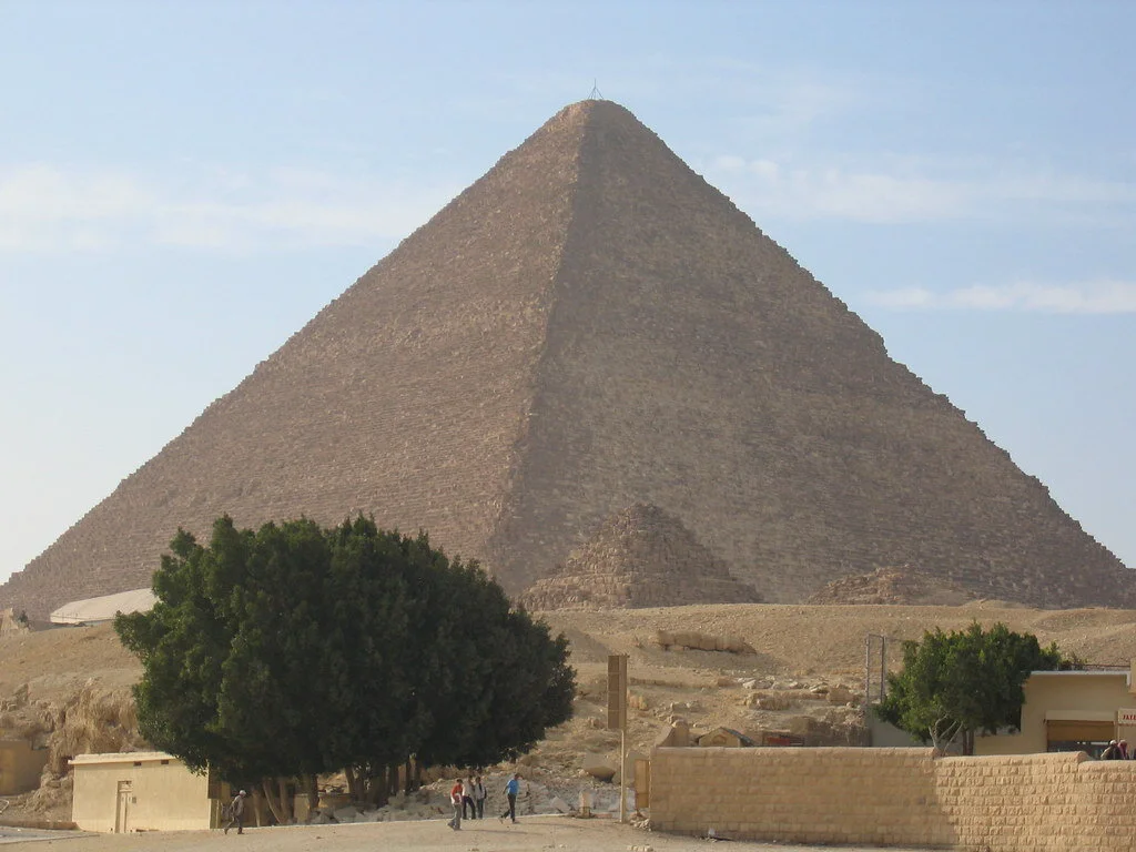
The Great Pyramid of Cheops. Boston Public Library. CC BY 2.0.
3. We still don’t know how they were built.
Although the pyramids are over 4,000 years old, professionals still don’t understand how the ancient Egyptians managed to build the pyramids without advanced technology. The most accepted theory is that they used ramps to bring materials to the top, which has been proven by a recent discovery. Researchers in Egypt discovered a 4,500-year-old ramp used to haul alabaster stones out of a quarry. The ramp system dates back to Pharaoh Khufu, who built the Great Pyramid of Giza. However, the way in which the ancient Egyptians built the pyramids is still a mystery because the pyramids were not made of alabaster, which is what the discovered ramp helped to move.
Khufu’s Great Pyramid. Bernt Rostad. CC BY 2.0.
4. There is a secret chamber in the Great Pyramid of Giza (Khufu’s Pyramid).
Weighing in at 5,750,000 tons, the Great Pyramid is simply a feat of architecture. To add further to the mystery, a previously unidentified chamber in the Great Pyramid was discovered in 2017 when physicists used the by-products of cosmic rays to reveal an at least 100-foot long void. The mysterious space’s dimensions are similar to the pyramid’s Grand Gallery, which is the corridor that leads to the burial chamber of Pharaoh Khufu. What lies within the space is still unknown, as well as its purpose. Scientists hope to find out more about this newly discovered area and what it was used for.
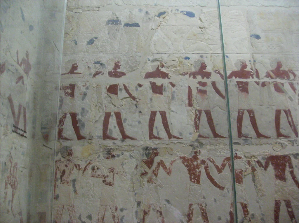
Tomb of Perneb, carving of offering bearers. Peter Roan. CC BY-NC 2.0.
5. It was tradition for the living to share food with the dead.
Ancient Egyptians believed that tombs were eternal homes for the mummified bodies and the ka spirits that lived within them. Each tomb had a tomb-chapel where families and priests could visit the deceased and leave offerings for the ka, while a hidden burial chamber protected the mummified bodies from potential harm. Visitors offered food and drink to the dead daily, and once the offerings were consumed by the ka, the living were free to eat and drink their offerings. The Beautiful Feast of the Valley was an annual festival of death and renewal where families spent the night in the tomb with their ancestors and feasted with them in celebration of their lives.

A statue ofNefertiti in the Altes Museum in Berlin. George M. Groutas. CC BY 2.0.
6. Egyptian women and men had equal rights.
In ancient Egyptian times, men and women of the same social class were treated as equals in the eyes of the law. Women could sell, own, earn, buy and inherit property. If widowed or divorced, women could raise their own children. Women could also bring cases before a court. Overall, women could legally act on their own and were responsible for their own actions. Although everyone in ancient Egypt was expected to marry, wives still had an important, equal and independent role in their marriage.

Isabelle Durso
Isabelle is an undergraduate student at Boston University currently on campus in Boston. She is double majoring in Journalism and Film & Television, and she is interested in being a travel writer and writing human-interest stories around the world. Isabelle loves to explore and experience new cultures, and she hopes to share other people's stories through her writing. In the future, she intends to keep writing journalistic articles as well as creative screenplays.

A man in a Zoot Suit. ANGELOUX. CC-BY-SA 2.0.
Pachuco: A Short History of a Timeless Style
Mexican and Mexican American “Pachuco” culture formed in the late 19th century along the the US-Mexico border. Zoot suits and lowriding cars are popular symbols, but the unique look singled out Pachucos as targets of racial discrimination, such as the Zoot Suit Riots in Los Angeles in 1943.
Read MoreAustralia’s Underground Town
In the 100-year-old mining town of Coober Pedy, Australia, more than half of the population lives underground, escaping the heat.

An underground bookstore in Coober Pedy, Australia. Smart Encyclopedia. CC BY-NC 2.0
Over half of the few thousand residents of Coober Pedy, Australia, live underground. The town was founded over 100 years ago, in 1915, when a teenage boy out prospecting for gold discovered opals. A settlement was quickly established and miners began to flock to the area. Coober Pedy became one of the largest opal mining operations in the world, producing around 70% of the world’s opal and earning the title “Opal Capital of the World.”
But the settlers of Coober Pedy had a problem: Coober Pedy is hot, with temperatures in the summer rising to over 113 degrees Fahrenheit in the shade. The opposite extreme is true during winter nights when the desert becomes very cold—considering this, life aboveground is greatly impacted by the weather. Rather than moving to a more temperate climate where opportunities for mining work would be more difficult to find, the settlers took inspiration from the mining industry itself, carving underground and hillside dugouts. In these cooler dugouts, the temperature stays at 75 degrees Fahrenheit year-round.

Chimneys rise from underground homes in Coober Pedy. Nicholas Jones. CC BY 2.0
The inhabitants’ subterranean lifestyle earned Coober Pedy its name, a corruption of the Aboriginal phrase “kupa piti,” which is often translated as “white man in a hole.” The name Coober Pedy was made official in 1920, but the settlement was not declared a town until the 1960s, after which it underwent another population boom and further development.
Today, the underground residences have all the amenities that a regular home would on the surface, such as internet, water and electricity, as well as multiple bedrooms, bathrooms and living areas. Some homes, like the one carved by Faye Nayler and two of her friends, even have a swimming pool and bar. A large portion of the population live most of their life underground, and it is a comfortable and relatively normal lifestyle—aside from the lack of sunlight. There are stores, churches and museums underground alongside the residences; the town truly is an underground community. Coober Pedy’s inhabitants do have to venture aboveground for food, however, because both of the town’s grocery stores are located on the surface.

An underground church in Coober Pedy. Werner Bayer. CC BY 2.0
Coober Pedy is still a worldwide hub for precious opal, but mining is no longer its only major industry. The town has become a popular attraction for visitors hoping to experience subterranean life. Visitors can stay in hotels with underground accommodations, like the Desert Cave Hotel. Another lodging option is a homestay in family-operated underground apartment-style accommodations like Di’s Dugouts or the Underground B&B. There are also underground campgrounds available to book.

A hotel in Coober Pedy. Smart Encyclopedia. CC BY-NC 2.0
While the underground lifestyle is Coober Pedy’s main draw, visitors can also explore other attractions such as the Centenary Mosaic Garden; Kanku Breakaways Conservation Park, which is an Aboriginal heritage site; and can even try their hand at mining for opal using a digging technique called noodling. Faye Nayler’s house is now open to visitors as Faye’s Underground Home, where visitors can pay a small entrance fee to receive a guided tour of the house. There are a number of other tours available around Coober Pedy for visitors to learn more about the town’s unique history.

Rachel Lynch
Rachel is a student at Sarah Lawrence College in Bronxville, NY currently taking a semester off. She plans to study Writing and Child Development. Rachel loves to travel and is inspired by the places she’s been and everywhere she wants to go. She hopes to educate people on social justice issues and the history and culture of travel destinations through her writing.
Cultural Significance of the Summer Solstice in Greece
For the past 2,500 years, Greece has been celebrating the summer solstice as a time of equality. Today, some Greeks have carried these traditions forward.

Sunset over Oia, Greece. Eugene Chan. Unsplash.
The summer solstice marks the longest period of daylight in the calendar year, as well as the official beginning of summer. The exact date of the solstice changes by a few days each year depending on the Earth's position in orbit around the sun. This year, it is expected to fall on June 20th in the Northern Hemisphere. While many countries have specific celebrations of the summer solstice, Greece has some of the most unique and meaningful traditions to commemorate the event in modern times.
The importance of the summer solstice to the Greeks dates back to the creation of calendar systems, many of which were developed based on geographical region. For example, the Athenian calendar spanned from summer solstice to summer solstice, and the Delphic calendar began around the first new moon after the solstice.
This solar orientation led ancient Greek communities to develop new year celebrations around the summer solstice, the most prominent being the festival of Kronia. The celebration was devoted to Kronos, the father of Zeus, and was a harvest festival.
The festival of Kronia was unique because it temporarily diverged from the ancient Greek rigid social hierarchy. It marked a momentary freedom from class restraints where slaves and lords celebrated together, sometimes even reversing roles, in order to mimic Kronos’ “Golden Age” of equality and peace.
The solstice was also preserved through rituals and routines, such as lighting fires at crossroads. This practice allowed communities to purge their homes of waste by discarding items into the fire, and was representative of renewal. Furthermore, it was believed that jumping over these fires would allow hopes and dreams to come true.
Many summer solstice festivities revolve around the themes of purifying and rebirth, and serve as an opportunity for communities to cleanse themselves of the past—similar to New Year's resolutions. Many of these traditions are still practiced today by some Greek communities. However, the equality represented in the ancient festival of Kronia is exemplified differently today, due to the abolition of the ancient Greek rigid social hierarchies
Rather than physical equality between social levels, equality is represented through social harmony and peace. This is most prevalent in the annual trek to the peak of Mt. Olympus which celebrates the summer solstice and is believed to emulate a similar sense of harmony.

The peak of Mt. Olympus in Greece. Billy Onjea. Unsplash.
Over the years, the Greeks have continued to recognize the rich cultural significance of the summer solstice. They have not only adapted old customs to fit modern times, but have also developed new ones which continue to honor the renewal and revitalization that a new cycle of time brings.

Zara Irshad
Zara is a third year Communication student at the University of California, San Diego. Her passion for journalism comes from her love of storytelling and desire to learn about others. In addition to writing at CATALYST, she is an Opinion Writer for the UCSD Guardian, which allows her to incorporate various perspectives into her work.
VIDEO: India’s "Death Hotels"
Varanasi, the most sacred of India’s seven holy cities, is home to several so-called “death hotels.” Unlike their morbid name, these hotels are actually places of peaceful worship where devout Hindus aspire to reach moksha — liberation from the infinite cycle of rebirth. Believers check in and remain until they die, a time that ranges from days to years. This video explores the ancient, often emotional, rituals of preparing for moksha from the viewpoint of hotel owners, pilgrims, cremation workers, and the family of those soon to be departing. Set on the banks of the Ganges River, it intertwines themes of religion, caste, family, and mortality into a masterpiece that shows an entirely new perspective on how to deal with death.
Chernobyl Becomes a Symbol of Resilience, 35 Years After Disaster
Time and time again, humans have been ravaged by disaster, only to successfully prove their resilience. Thirty-five years after the Chernobyl nuclear disaster, Ukrainians appear eager to rewrite their story.

The abandoned streets of Chernobyl, Ukraine. Pedro Moura Pinheiro. CC BY-NC-SA 2.0.
The Chernobyl nuclear disaster of 1986 marked chaos for the Soviet Union and still influences modern-day Ukraine. The accident was caused by a series of technical faults, resulting in a nuclear explosion that spewed radioactive substances into the air. Chernobyl stands as the most devastating nuclear incident to have ever occurred, with 31 deaths as a direct result of the meltdown, 4,000 cancer deaths from exposure to radiation and millions affected in various other ways.
President Volodymyr Zelenskyy announced that Chernobyl will now function as a nuclear waste site.
Now, at the 35th anniversary of the Chernobyl disaster, Ukrainians are determined to move forward. Life has slowly begun to return to the area; the “exclusion zone” stands as a prime example of the resilience of nature. What was once a deadly zone, marked as a no man’s land, now abounds with life. Radiation levels in the area have decreased over the years, creating a nature preserve of sorts—elk, deer and other wildlife graze throughout the empty space.
As frightening as Chernobyl may seem, locals have moved back. Elderly residents have returned to the surrounding area despite being advised against it; for them, the comfort of home outweighs the peril of living in the region. These residents stand as a reminder of the power—and the risks—that follow one’s determination.
Officials in Ukraine hope that Chernobyl will be added as a World Heritage Site, as many residents believe that the outsize influence of the site merits its inclusion.
Once wholly abandoned, Chernobyl and the nearby town of Pripyat allow visitors today. Travelers come to the site and find an unconventional experience; the disaster has created a reflective tone, as Chernobyl’s tragic history sheds light on the lows of human struggle and the highs of human triumph.
On April 26, Ukrainian President Volodymyr Zelenskyy announced that Chernobyl will now function as a nuclear waste site. It is projected that the nuclear waste site will save Ukraine about $200 million per year.
Zelenskyy also promised to “transform the exclusion zone, as Chernobyl is referred to, into a revival zone.” While it won’t be easy, Ukraine intends to move on from the past and head toward a stronger future.
As time passes, many tragic incidents of history dissolve from the spotlight. With revival on the horizon, Ukraine hopes for a triumph at Chernobyl.

Ella Nguyen
Ella is an undergraduate student at Vassar College pursuing a degree in Hispanic Studies. She wants to assist in the field of immigration law and hopes to utilize Spanish in her future projects. In her free time she enjoys cooking, writing poetry, and learning about cosmetics.
A Look at Germany’s Quirky but Quaint Ore Mountains
Germany’s Ore Mountains offer bucolic scenery and countless Christmas traditions, all wrapped up into one charming package.

Seiffen, Germany. abejorro34. CC BY-NC 2.0.
Along the German-Czech border lie the Ore Mountains, one of nature’s grand masterpieces. Stretching over 100 miles, the Ore Mountains appear like a scene out of Narnia: long strips of deep woods sit sprinkled among patches of bright wildflowers, often blanketed in thick snow. The area’s splendid scenery presents itself as the ideal inspiration for painters in search of inspiration.
The history of the region is just as fascinating. Up until their expulsion after World War II, German miners worked the mountain range for its many minerals such as copper, silver and lead. Thus, the range gained its name: the Ore Mountains. After World War II, the small towns that peppered the range lost most of their German populations. These towns were later filled by Czech residents who developed uranium and coal mining. Now, the range’s travel industry has brought much attention to the quaint lifestyle found today in these small towns.
For guests eager for a gorgeous view or photographers looking for the perfect shot, Fichtelberg Mountain stands as one of the Ore Mountains’ top stops. Fichtelberg Mountain is the second-tallest peak of the Ore Mountains; it sits in the middle of the range and stands nearly 4,000 feet tall. The icy conditions found in the winter attract throngs of alpine skiers, bobsledders and other snow sporters. When the weather warms toward summer, the crowds of snow sporters are replaced by hikers and photographers; trails through patches of woods make for calm hiking opportunities, while the peak itself provides a 360-degree view of the surrounding mountain range.

Snow in the Ore Mountains. VicunaR. CC BY-SA 2.0.
Another destination sure to pique anyone’s interest is the small town of Seiffen, Germany. Seiffen holds only around 3,000 people, but its influence as a stronghold of local culture makes up for it. The town is famous for its role in the toymaking industry, with over 100 craftsmen living in it alone. Seiffen often appears like something out of Christmastime folklore, as it is known for its top-notch toymaking and stellar artisan Christmas decorations. For the woodmakers of this town, their craft is far more than just a profession. It is common that the artisans of Seiffen pass their craft down from generation to generation, making their work not just a form of income, but a lifestyle.
Although at first glance the Ore Mountains may appear to be just another mountain range, the wide variety of activities and rich history make it a fascinating spot to explore.

Ella Nguyen
Ella is an undergraduate student at Vassar College pursuing a degree in Hispanic Studies. She wants to assist in the field of immigration law and hopes to utilize Spanish in her future projects. In her free time she enjoys cooking, writing poetry, and learning about cosmetics.
Angola: A Video of Culture, Diversity, and the Lasting Legacy of Civil War
Having been ravaged by civil war from 1975-2002, Angola is a country still reckoning with its complex history. This legacy of colonization means that Angola has had to rely largely on raw natural resources for economic development. However, it’s been slowly stabilizing for the past decade, recovering from its past and getting ready to face the world of today. Although there has been significant strides in modernization, Angola retains much of its cultural and geographic diversity, boasting both crowded cities and remote salt flats and sea cliffs. This video takes you through many different regions of the country, showing the diversity present in both the people and their environment while giving information about the nation’s history. Each group of people interact differently with their surroundings and cultural influences, emphasizing something westerners often forget: Angola, and Africa itself, is far from a monolith.
Altered Photos of Cambodian Genocide Victims Spark Outrage
Too often history is viewed as an element of the past—chains of unchangeable events that can be analyzed and nothing more. However, it is important that victims of past atrocities are honored, a lesson in which modern media has fallen short.

Unaltered photos of Khmer Rouge genocide victims at the Tuol Sleng Genocide Museum. Christian Haugen. CC BY 2.0.
With the advancements of the digital age, the culture of media has grown ever more rapid, often leading to negative consequences. In a recent incident, history itself took center stage as one photographer’s actions sparked massive outrage among victims of the Khmer Rouge genocide, which led to the deaths of more than 2 million Cambodians in the late 1970s.
Vice published the work of photographer Matt Loughrey, who edited photos of victims from the S-21 prison in Phnom Penh taken minutes before their executions. Loughrey has been accused of editing the photos so that they show smiling faces, creating waves of backlash for the photographer.

Torture room. Timoluege. CC BY-NC 2.0.
Upset relatives of the photographed victims stated that Loughrey’s work was of horrible judgment, citing his acts as degrading the dignity of the victims. Cambodian officials too were outraged upon seeing the photos; the country’s Ministry of Culture and Fine Arts threatened legal action. In addition to insensitive alterations of the photos, the Vice article misidentified one of the victims, publishing incorrect personal details.

Victims’ skulls. istolethetv. CC BY 2.0.
Others have declared the actions of Loughrey to be crimes against history itself, stating the alterations to be offensive to truth.
VICE has since removed the photos, citing errors in the company’s editorial process.
The Bigger Picture
Beyond the first waves of anger resulting from this incident, larger lessons have been learned by all involved. Primarily, the incident has brought to light a flaw in the way people view history; although history is an analysis of past events, it must be equally weighted against potential consequences for the victims themselves. Second, it highlights that history is not always entirely of the past—there are still over 5 million Khmer Rouge victims living, along with millions of other descendants and close community members. Third, it brings up the question of what should be considered acceptable when it comes to altering representations of history. Is there wiggle room for subjectivity, or should all journalistic representations be as objective as possible?
Amid the turmoil and animosity between the opposing sides of this conflict, some light still remains. The incident stands as a crucial reminder for everyone that the analysis of history can be as much a weapon as a tool. It remains up to the media, and their audiences, to use the past appropriately.

Ella Nguyen
Ella is an undergraduate student at Vassar College pursuing a degree in Hispanic Studies. She wants to assist in the field of immigration law and hopes to utilize Spanish in her future projects. In her free time she enjoys cooking, writing poetry, and learning about cosmetics.
A Glimpse at Azerbaijan, Central Asia’s ‘Land of Fire’
Although a relatively new nation, Azerbaijan’s multifaceted culture from its historic tea rituals to its unique pomegranate festival makes it especially intriguing.

A mountainous region in Azerbaijan. Pozziss. CC0.
Azerbaijan, a former Soviet republic located in the southern Caucasus, stands as a diverse and exquisite country. Although the Russian imperialism of the past retains some influence, the “Land of Fire” prides itself on its many unique traditions which can be fully experienced today.
Tea Rituals

Black tea served in an armudu. Idin Ebrahimi. Unsplash
Tea is a prevalent part of Azeri culture, to the extent that it is served with every meal. The locals predominantly drink black tea and serve it in a pear-like glass called an armudu. This tradition was passed down from medieval times, when black tea was taken alongside a sugar cube to avoid assassination, as sugar tends to react with potential toxins in the drink. This tradition continues even today, as locals can be seen taking a bite of a sugar cube before sipping their tea.
The Importance of Fire
Temple of Fire in Baku. Diego Delso. CC BY-SA 4.0
Azerbaijan is also known for its national symbol of fire, and the country is recognized as a place where “the sacred fire is preserved.” “Azer” in Persian means “fire,” and the entire country is known as the “Land of Fire.” Although the exact reason behind this cannot be tracked to one specific moment, there are various potential reasons for why fire holds such a special place in this nation. First, although a large proportion of Azeris are Muslim, Zoroastrianism still holds a large influence on Azerbaijan. Zoroastrianism focuses on the worship of fire, water, Earth and wind. Thus, respect for nature is highly ingrained within Azeri culture. Moreover, the country’s “huge underground gas deposits” commonly lead to natural flames.
Food

Azeri dish known as kelem dolmasi. CC BY 3.0
Food is also a large part of Azeri culture, and one can find an array of distinct, delicious and healthy dishes. The reason for this is the large farming culture in Azerbaijan, which is possible due to the country’s extensive tracts of fertile land. This means that the nation grows a multitude of vegetables and fruits, with flavorful meats and herbs rounding out Azeri meals. Due to Azerbaijan’s vibrant culinary scene, food is given a high position in culture, where sharing food with another person is a sign of friendship.
Goychay Pomegranate Festival

A booth at the Goychay Pomegranate Festival. Moonsun1981. CC BY-SA 3.0
Although many fruits are popular in Azerbaijan due to its fertile land, pomegranates are given the highest title as the symbol for love, luxuriance and eternal life. To commemorate the importance of this fruit, a pomegranate festival known as Nar Bayrami is celebrated every November in the city of Goychay, where over 50,000 tons of pomegranates are produced annually. Guests in this festival are welcomed by locals with an array of pomegranate dishes ranging from jams to baked goods to juices. Moreover, during the festival many vendors set up their shops with distinct varieties of this fruit. Other festivities include traditional dancing, instrumental music by local musicians, and competitions such as picking out the heaviest pomegranates from the lot.
Strides Toward Gender Equality

Kalbajar School in Azerbaijan. World Bank Photo Collection. CC BY-NC-ND 2.0
In 1918, Azerbaijan became the first country in the Islamic world to give women the right to vote. Gender equality comes partly as a legacy of Russian imperialism, as the culture placed large importance on respecting women. Women’s equality continues to be a notable social norm in Azerbaijan, and it is normal for Azeri women to hold positions of political power. On a day-to-day basis, men commonly offer their seats to women and hold the door for them.
Gracious Hospitality

Two Azeri women picking out tomatoes. Asian Development Bank. CC BY-NC-ND 2.0
Generous behavior isn’t only reserved for women in Azerbaijan; it extends to guests as well. Hospitality is a common trait across the majority of Azeri citizens, who are often willing to provide shelter and food to their guests, regardless of the trouble they must go through. If one receives the luxury of going to a Azeri’s home, they should remember to take off their shoes before entering, and to remain standing until told where to sit. Moreover, as Azerbaijan is renowned for its food, guests should not refuse a serving as that may be misunderstood as a rude gesture.
In all, Azerbaijan’s riveting culture makes it an intriguing nation to visit. Despite its minuscule size, the country has much to offer to those willing to take a chance on it.
WANT TO LEARN MORE? CHECK OUT THIS VIDEO AND EXPLORE THE MAGNIFICENCE OF AZERBAIJAN.

Swati Agarwal
Swati is a sophomore at University of California, San Diego, where she is studying Environmental Sciences and Theatre. Although born in India, she was raised in Tokyo, which gave her the opportunity to interact with diverse people from distinct cultures. She is passionate about writing, and hopes to inspire others by spreading awareness about social justice issues and highlighting the uniqueness of the world.
10 Indigenous American Historical Sites to Visit
Ten million people lived in what is now the United States before Europeans arrived. These Indigenous Americans lived in complex cultures and completed amazing architectural feats that persevere to this day.

By the time European explorers arrived in the Americas, the Western Hemisphere was already home to more than 50 million people. Ten million of these people lived in what is now the United States. These Indigenous Americans developed intricate communities, religions and lifestyles, and made a lasting impact on American history and culture. Incredible sites built by Indigenous people can be found throughout the U.S. today, including cliff dwellings, multistory stone houses, earth lodges and effigies, and other stunning ruins. The history of Indigenous people is often overlooked or swept under the rug in favor of European colonists when looking at the larger context of American history, but preserved sites teach visitors about the complex cultures that came before Western settlers. These 10 sites showcase some of the impressive architectural triumphs of Indigenous people and pass on their histories.

1. Knife River Indian Villages National Historic Site, North Dakota
Located near Stanton, North Dakota, the Knife River Indian Villages National Historic Site preserves the history of the Knife River region. The Knife River region, an area in North Dakota centered around a tributary of the Missouri River, has been home to a number of people groups for around 11,000 years. Not much is known about the cultures that have inhabited the Knife River region because very few artifacts from the area remain, but early written records document the lives of the Hidatsa people. Like the Mississippian people, the Hidatsa resided in earth lodges. The Mandan and Arikara were also earth lodge residents who settled in the Knife River region, and all three groups pioneered agriculture in the area while still hunting and gathering. Villages were the center of earth lodge peoples’ lives, and the park features the remains of three large villages constructed by the Hidatsa: Awatixa Xi’e village, Hidatsa village and Awatixa village.

2. Puu Loa Petroglyphs, Hawaii
Hawaii Volcanoes National Park, on Hawaii’s Big Island, protects Mauna Loa and Kilauea, two of the world’s most active volcanoes. It is also home to the Puu Loa petroglyphs, stone etchings that document the lives and culture of the Native Hawaiian people. The petroglyphs are located in a lava field that is at least 500 years old, and the site has over 23,000 different petroglyphs. There are a variety of geometric designs, as well as depictions of people and tools, such as canoe sails. A number of the petroglyphs contain cupules, or holes where a portion of the umbilical cord was placed after the birth of a child in order to ensure long life. The first known written account of the petroglyphs is attributed to missionary Rev. William Ellis in 1823, but some petroglyphs likely date to the 1600s or even earlier. In addition to being used to ensure long life, some petroglyphs were used to record the movements of travelers on the island. Visitors to Hawaii Volcanoes National Park can take a 1.4-mile round trip day hike on a boardwalk to admire the petroglyphs up close.
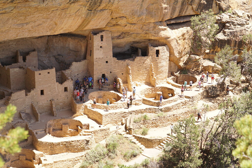
3. Mesa Verde National Park, Colorado
Probably one of the most well-known Indigenous sites in the United States, Mesa Verde National Park in Colorado preserves almost 5,000 historical sites of the ancestral Pueblo people, including 600 cliff dwellings. The ancestral Pueblo people lived at Mesa Verde for more than 700 years, from 550 to 1300 A.D. The first people settled at Mesa Verde in 550 A.D., turning from hunting and gathering to agriculture and building small villages of pithouses, sometimes sheltered in cliff alcoves. Around 750 A.D., these people began building houses above ground and became known as the Pueblo people, meaning “village dwellers.” The houses evolved from being made of poles and mud to being skillfully constructed from stone. Then, in 1200 A.D., for reasons that are unknown, the ancestral Pueblo began to move back into cliff alcoves and developed the cliff dwellings that make Mesa Verde famous. Mesa Verde’s cliff dwellings are truly incredible examples of Indigenous architecture, ranging from one- to 150-room houses. They are also some of the best-preserved cliff dwellings in North America, and visitors can tour some of the structures, like Balcony House and Cliff Palace.

4. Effigy Mounds National Monument, Iowa
Ceremonial mounds created by Indigenous Americans can be found across the United States. Effigy Mounds National Monument preserves more than 200 distinct mounds built by people known as the Woodland Indians and gives visitors a glimpse directly into Woodland Indian culture. The mounds, found in northeastern Iowa, are unique because a large number of them are effigies in the shape of animals. Thirty-one of the mounds are bear or bird effigies. The Woodland culture consisted of hunter-gatherers who during the summer lived in large campsites along the Mississippi River, which they relied on for food and water. Archaeologists and researchers do not know precisely why the effigy mounds were built, but they guess that they may have been made for religious rituals or burial ceremonies. Guided tours are available throughout the summer at Effigy Mounds to teach visitors more about the area’s rich history, and there are also hiking trails around the site.

5. Chumash Painted Cave State Historic Park, California
Just outside of Santa Barbara sits the Chumash Painted Cave, a room-sized sandstone cavern filled with colorful anthropomorphic and geometric figures. The exact age of the cave paintings is unknown, but archaeologists estimate that they date to the 1600s or earlier. The paintings are attributed to the Chumash, a name referring to several groups of Indigenous people who lived along the coast of Southern California and on the nearby Channel Islands. The Chumash groups spoke a variety of what linguists refer to as the Hokan language, and they constructed canoes from pine or redwood planks, which they used to sail up and down the California coast to hunt, gather and trade with other tribes. The Chumash lived in round homes known as “aps,” organized into villages. A number of archaeological sites displaying Chumash rock art have been discovered, and the Chumash Painted Cave is one of the most well preserved. The meaning behind the figures at the painted cave is unknown, but the art may be connected to Chumash astrology and cosmology.

6. Chaco Culture National Historical Park, New Mexico
A valley in the high desert of northwestern New Mexico houses an ancient, sprawling center of ancestral Pueblo culture. Between 850 and 1250 A.D., the area that is now Chaco Culture National Historical Park was the epicenter of a widespread expansion of Chacoan culture. The Chacoan people used unique masonry techniques to construct stone houses multiple stories high, some containing hundreds of large rooms. The buildings were intricately planned out and often constructed according to solar, lunar and cardinal directions, as well as to maintain clear lines of sight between houses. By 1050, Chaco was the economic and cultural center of the San Juan Basin, with people from all over the area gathering there to share knowledge and traditions and to participate in ceremonies. A number of the great houses have been preserved and can be seen today, along with petroglyphs made by the Chacoan people. Since 2013, Chaco has also been designated an International Dark Sky Park, meaning it is one of the best places in the country to get a view of the night sky untainted by light pollution. Visitors can look at the sky the same way the Chaco people saw it a millennium ago.
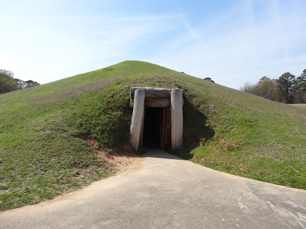
7. Ocmulgee Mounds National Historical Park, Georgia
Minutes outside of downtown Macon, Georgia, lies Ocmulgee Mounds National Historical Park, a site shaped by 17 millennia of habitation, dating back to prehistoric times. The nomadic Paleo-Indian people arrived at the site in around 17,000 B.C., during the last ice age. Around 9,600 B.C. the Paleo-Indian era gave way to the Archaic era. The Early Archaic people were nomadic hunters as well, but evidence suggests that by the Middle Archaic period people began to build more permanent settlements and gather food. It wasn’t until the Mississippian people, who migrated to the area in 900 A.D., that the land was permanently changed, however. The Mississippians constructed impressive villages that literally reshaped the landscape, forming elaborate earthen lodges and temples that are still visible today. The Mississippian culture declined after the 1539 arrival of Spanish explorer Hernando de Soto, who brought with him foreign diseases that devastated the Mississippian people. Descendants of the Mississippian people, the Muscogee Creek Nation, who lived at Ocmulgee from 1600 until their forcible removal by Andrew Jackson in 1836, considered the mounds built by their ancestors to be sacred. Today, visitors to the site can see several of the mounds constructed by the Mississippian people, as well as the location of two Civil War battles.

8. Little Bighorn Battlefield National Monument, Montana
Little Bighorn Battlefield National Monument memorializes the site of the Battle of Little Bighorn, a fight between the 7th Regiment of the U.S. Cavalry and thousands of Sioux, Cheyenne and Arapaho tribe members. It lies within the Crow Indian Reservation in southeastern Montana. On June 25, 1876, the 7th Regiment, led by Lt. Gen. George Custer, attacked a village of free Lakota and Cheyenne people. The battle was part of the U.S. campaign to force Indigenous people to comply with the 1868 Treaty of Fort Laramie, which created a large reservation in South Dakota intended to house the Lakota. Many Lakota did not want to give up their nomadic lifestyle in favor of a life controlled by the U.S. government, resulting in a number of armed conflicts. The Battle of Little Bighorn proved deadly for both sides, but the Lakota and Cheyenne ultimately triumphed, defeating Custer and his troops. Though the Lakota and Cheyenne tribe members won the battle, Custer’s defeat became a rallying cry for U.S. efforts to force Indigenous people onto reservations, and stronger military forces were sent to conquer the tribes. The monument includes the battlefield itself, as well as the Custer National Cemetery and a number of hiking trails.

9. Aztec Ruins National Monument, New Mexico
Despite its name, Aztec Ruins National Monument has no association with Mexico’s Aztec empire. These large, multistory stone buildings, located within the city limits of Aztec, New Mexico, were constructed by the ancestral Pueblo. Early Western settlers thought that the site was built by the Aztecs, so they named the area “Aztec,” and the name remained even after the true builders of the ruins were discovered. Aztec Ruins was the largest ancestral Pueblo community in the Animas River valley. The site features a number of “great houses” made of stone, including the West Ruin, which had over 400 interconnected rooms. Each great house had a “great kiva,” a large, underground circular chamber used for ceremonies. Aztec Ruins also has three above-ground kivas, each encircled by three walls forming a triangle. Aztec Ruins was likely influenced by Chacoan culture, and may have even been an outlying community of Chaco. Visitors can wander through the rooms of West Ruin on a self-guided tour, or participate in ranger-led programs.

10. Hopewell Culture National Historical Park, Ohio
The term “Hopewell culture” refers not to a specific tribe, but to a “distinctive set of artifacts, earthworks and burial practices” common in areas of southern Ohio during the Middle Woodland period, from around 1 to 400 A.D. The Hopewell Mound Group is an 130-acre earthwork complex, which contains 29 burial mounds and was once enclosed by an enormous earthen wall that spanned over 2 miles and was up to 12 feet high. Remnants of the walls are still visible, as are several of the large, uniquely shaped mounds. Hopewell Culture National Historical Park encompasses five additional sites, all with fascinating remnants of the Hopewell culture. Settlements typically consisted of a few families living close together in rectangular houses with a shared garden nearby. In addition to growing domesticated plants, people of the Hopewell culture were hunters, fishers and gatherers. Visitors to the park will discover the commonalities between each distinct site by exploring the incredible Hopewell Mounds and looking at preserved artifacts.

Rachel Lynch
Rachel is a student at Sarah Lawrence College in Bronxville, NY currently taking a semester off. She plans to study Writing and Child Development. Rachel loves to travel and is inspired by the places she’s been and everywhere she wants to go. She hopes to educate people on social justice issues and the history and culture of travel destinations through her writing.
Exploring the Wonders of Australia’s Wild and Remote Kimberley
The Kimberley region of Western Australia boasts a spectacularly diverse landscape offering both biodiversity and impressive geological formations.

Aerial view of the Kimberley. Drumsara. CC-BY-SA 2.0.
Although Australia provides plenty of examples of nature’s extraordinary beauty, few compare to the Kimberley region. Situated in Western Australia’s northernmost corner, the Kimberley is a grandiose territory teeming with rich ecosystems. A plethora of microcommunities sprinkle across its sundry landscapes while towering hills spill into vast canyons neighboring pristine swimming holes.
The region covers over 150,000 square miles, with only about 40,000 residents inhabiting the area. Perhaps the most famous part of the Kimberley is Broome’s Cable Beach, ranked as one of the world’s most gorgeous stretches of sand and sea. The beach displays nearly 14 miles of fine sand meeting glassy waters. The beach itself has an interesting history; the name “Cable Beach” comes from the telegraph cable placed there in 1889. For adventurers more daring, Tunnel Creek National Park houses the oldest cave system in Australia. Again, the history of the stop is fascinating; Aboriginal leader Jandamarra hid in the cave system but was later caught and killed at its opening.

The swirling sky at Cable Beach in Broome. hmorandell. CC BY-NC-SA 2.0.
However, the history of the land tells a story drastically different than the extravagant serenity the region now boasts.
Exploration of the Kimberley by Europeans was initiated in 1879 by government surveyor Alexander Forrest, who explored much of Western Australia. Upon arrival, Forrest made note of the region’s vast landscape which made it ideal for cattle grazing. From this point on, the resources of the land quickly became tied to conflict; diggers struck gold which led to a quickly fleeting gold rush, and conflicts over cattle grazing raged between the Indigenous population and newly arrived Europeans. In the mid-20th century irrigation projects led to the rise of extensive farming, primarily that of sugar cane and rice. Oil drilling and diamond mining are now conducted in the region.
Today, the Kimberley contains residents as diverse as its wildlife; there are over 100 Aboriginal communities that share the region’s unmatched tranquility as well as its bustling economic opportunities. Due to the region’s iconic landscape, nearly 300,000 travelers visit every year, producing over $300 million annually.

Tunnel Creek National Park. Nievedee. CC BY-SA 4.0.
As with most dazzling spectacles of nature, the region boasts pristine weather that complements the untouched wilderness. The wet season extends from November to April and is characterized by heavy rain and humid, sticky air. From May to October is the dry season, which is characterized by sun-drenched days and cloudless, baby blue skies.

Raft Point. Johnny. CC BY-NC 2.0.
An exciting history and a dazzling landscape make Australia’s Kimberley region a powerfully adventurous destination. Surely any visitor will find their imagination stretched by the area’s countless wonders.

Ella Nguyen
Ella is an undergraduate student at Vassar College pursuing a degree in Hispanic Studies. She wants to assist in the field of immigration law and hopes to utilize Spanish in her future projects. In her free time she enjoys cooking, writing poetry, and learning about cosmetics.

The Stonewall Inn in New York City’s Greenwich Village. The 1969 Stonewall riots are credited with starting the modern gay liberation movement. NPCA Photos. CC BY-ND 2.0
Discover These 8 Gay Villages from Around the World
Gay villages, or “gayborhoods,” are neigbhorhoods within cities that provide safe spaces for LGBTQ+ people to express themselves openly and form communities. Many gay villages feature bars and restaurants, vibrant nightlife and boundless queer history. Wherever one may find themselves, there is likely a gay village just around the corner waiting to be discovered. Here are eight gay villages from across the world.
1. Shinjuku Ni-chome, Tokyo

Buildings and neon lights in Tokyo’s Shinjuku ward. Andy Miller. Unsplash
In the heart of Shinjuku ward in Tokyo, between modern skyscrapers and dazzling neon-lit billboards, hides one of Asia’s most vibrant gay villages. Shinjuku Ni-chome, shortened to just Ni-chome, has the highest concentration of gay bars in the world. Ni-chome was once Tokyo’s red-light district, but when prostitution became illegal in Japan in 1956 it became Tokyo’s gay village. In a city known for its nightlife, Ni-chome is home to fusion restaurants and nightclubs open late into the night. Many of Ni-chome’s gay bars are small and personal, fostering their own tight-knit community within the city. Ni-chome was the location of Japan’s first gay pride parade in 1994, and is where the country’s first permanent LGBTQ+ center opened in 2020.
2. Oxford Street, Sydney

A brightly colored building near Taylor Square, Sydney. Ted McGrath. CC BY-NC-SA 2.0
Located in the Darlinghurst neighborhood of Sydney, Oxford Street is known for its nightlife, shopping and dining venues. It is also the heart of Sydney’s LGBTQ+ community, playing host to the annual Syndey Gay and Lesbian Mardi Gras. Unlike other Pride events, which usually occur around June, Mardi Gras is held in March, drawing over half a million attendees. The first Gay and Lesbian Mardi Gras was held in 1978. The organizers of the event were arrested and outed by the police, which garnered national attention. The next year in 1979, another event was held to commemorate the 10th anniversary of the Stonewall riots in New York City, as well as to bring attention to the events of the previous year. Every year since then, queer Australians have gathered along the western end of Oxford Street to socialize, party and remind Australia and the world that they will not be silenced.
3. Chueca, Madrid

Pride flags hang over a crowded street in Chueca, Madrid. Ted Eytan. CC BY-SA 2.0
Chueca is a timeless neighborhood in an already historic city. Located in the heart of Madrid, this gay village is defined by its lively crowds as much as by its many cafes and boutiques. Chueca’s annual gay pride event, known as Madrid Pride, is the largest in Europe with an average crowd of over 2 million people each year. The neighborhood also hosted WorldPride Madrid 2017, an international Pride event that promotes LGBTQ+ issues globally. WorldPride 2017 was one of the largest Pride events in history, attracting an estimated 3.5 million attendees. Chueca has more to offer than just shops and festivals. For those with a love for romance and history, one can visit the Church of San Anton, where visitors will find the bones of St. Valentine himself.
4. Buenos Aires, Argentina

Colorful buildings in Caminito, Buenos Aires. Barbara Zandoval. Unsplash
Unlike other major cities, Buenos Aires lacks a specific gay village. However, this doesn’t mean that Buenos Aires isn’t a gay-friendly city, or that there isn’t a queer community in the Argentine capital. Rather, LGBTQ+ travelers will find pockets across the city’s many barrios that cater to gay and straight patrons alike. San Telmo, Bueno Aires’ oldest barrio, is known for its historic streets and contemporary art installations. In the city’s largest barrio, Palermo, one can find both stunning botanical gardens and the city’s largest collection of gay bars and clubs. The belle epoque buildings of Barrio Norte can instantly transport travelers to the streets of Paris. None of these neighborhoods are explicitly Buenos Aires’ gay village. Rather, visitors and locals alike will find a queer-friendly environment all across the city. Argentina is a leader of LGBTQ+ rights in the region, becoming the first country in Latin America to legalize same-sex marriage in 2010. Regardless of where travelers find themselves in Buenos Aires, they will find a progressive city paving the way for gay rights and liberation.
5. Gay Village, Montreal

A Black Lives Matter street mural in Montreal’s Gay Village. Martin Reisch. Unsplash
Montreal’s Gay Village is one of the most prominent of its type in the French-speaking world. Known as “Le Village Gai” in French, the community had to overcome decades of oppression before becoming one of the most well-known gayborhoods in the world. During the 1970s, gay businesses in the city were regular targets of the police, who often raided bars and other establishments. Police violence didn’t deter Montreal’s LGBTQ+ population. Rather, Montreal’s gay residents formed a series of demonstrations to fight injustice against their community. Now the area is one of Montreal’s most popular neighborhoods. It draws visitors from all over the world, and hosts the largest Pride in Canada. Fierte Montreal, literally “Montreal Pride,” drew more than 3 million attendees in 2019, which also makes it the largest Pride in a French-speaking city (sorry Paris!). In classic Montreal fashion, two gay villages technically exist in Montreal: an English one located near downtown, and a French one on Saint Laurent Boulevard.
6. Canal Street, Manchester, England

Canal Street in Manchester, England. David McKelvey. CC BY-NC-ND 2.0
When one thinks of cosmopolitanism in the U.K., most think of London. However, travelers shouldn’t count out the city of Manchester. Canal Street easily competes with London’s Soho for the center of Britain’s queer scene. The street dates back to the early 1800s as a transportation hub, when Manchester was rapidly growing as a major industrial center. Canal Street derives its name from the Rochdale Canal which runs alongside it. By the 1950s, the neighborhood was facing urban decline. This was around the same time that Canal Street became Manchester’s main gayborhood. Like many gay villages around the world, the community faced hostility from police during the 1980s. It wasn’t until the 1990s that Canal Street was able to thrive openly as a gay village. Now the street is a proud and open community, drawing locals and travelers from both the U.K. and across the world. It is home to the annual Manchester Pride, the second-largest Pride event in Britain after London’s.
7. Ximending, Taipei, Taiwan
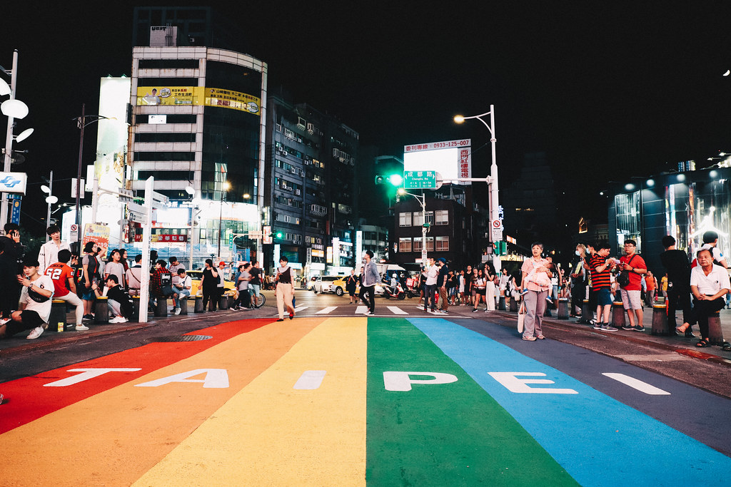
A rainbow-colored street in Taipei’s Ximending district. waychen_c. CC BY-NC-ND 2.0
Known for night markets and traditional temples, Taipei should be near the top of anyone’s list when traveling in Asia. It is also one of the most gay-friendly cities in the world, and a leading example of equal rights in the region. In 2019, Taiwan became the first and only country so far in Asia to legalize same-sex marrriage. This makes Taipei not only the center of gay culture in Taiwan, but a perfect example of what LGBTQ+ equality could look like in Asia. The city’s gay village is located in Ximending, a shopping area of the historic Wanhua district. Situated near the famous Red House Theater, Ximending offers a plethora of gay bars and nightclubs open late into the night. In a city like Taipei, you don’t need to be a local to enjoy what this friendly city has to offer travelers of all kinds. However, you might need to be a night owl to fully experience this gayborhood.
8. Schoneberg, Berlin

Nollendorfplatz in Berlin’s Schoneberg neighborhood. Schoneberg is the oldest gay village in the world. Oh-Berlin.com. CC BY 2.0
Located in the western part of Berlin, Schoneberg’s history as a gay village spans nearly a century. The neighborhood’s roots lie as a village in the Middle Ages, all the way back in the 13th century. In the 1920s, as Berlin grew in size, Schoneberg became a part of the German capital. That is around the same time the area became the center of the city’s emerging queer scene. Gay nightclubs and other venues flourished during the Weimar Republic, before almost all of them were shut down when the Nazis seized power in 1933. Now, Schoneberg is once again a proud gay village. Much of the gay life in the neighborhood is centered around Motzstrasse, a street that goes right through the center of Schoneberg. The street is where Berlin’s Lesbian and Gay City Festival is held each year, one of the largest of its kind in Europe. Whether one comes for its history or its nightlife, Schoneberg is a constant reminder that queer people have always been a part of Berlin life, just as they have been a part of communities around the world.

Aerex Narvasa
Aerex is a current student at Occidental College majoring in Diplomacy and World Affairs with a minor in East Asian Studies. He is passionate about sharing people’s stories through writing, and always strives to learn about new places and cultures. Aerex loves finding new music and exploring his hometown of Los Angeles in his free time.
Heartwarming Video Tracks Down a Long-Lost Photograph Across Cultures
Photography has played a large part in Chinese culture, adding a unique facet to memory documentation that is not often known to most outsiders. One vintage photo with an incredible back story exemplifies this. This mini documentary tells the tale of this photo through Chinese amateur photographer Xu Zhen and French photo archivist Thomas Sauvin; these two men helped create and preserve a timeless piece of history. This video is heartwarming, eye-opening and will change your view about Chinese photography and culture.
7 Dazzling Light Festivals
What better time to explore a new city than during a magnificent festival of lights? These seven festivals are annual events sure to immerse visitors in vivid lights and unique cultures.

Lights are an important part of culture and art around the world. They symbolize new beginnings, celebrate historic traditions and are glimmering, eye-catching sources of entertainment. Many countries host annual festivals with lights at their center. These seven light festivals display floating lanterns, light sculptures, intricate projections and even raging bonfires. The lights on display vary from festival to festival, as does the history behind each event, but every event is sure to dazzle visitors.

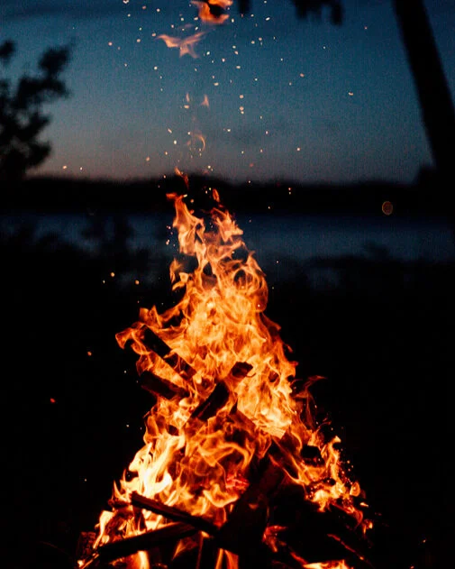
1. Las Fallas de Valencia, Spain
Each year over a million revelers gather in Valencia, Spain, for this five-day fire festival. Las Fallas begins on March 15, when more than 700 “ninots,” towering statues made of cardboard, papier mache, wood or plaster, are set up around the city. The ninots are eye-catching: often multiple stories tall, colorful and exaggerated depictions of current events and satirical scenes. Las Fallas originates from an old carpenter's tradition of burning materials on March 19 to celebrate the arrival of spring. The carpenters’ bonfires of old wood and rags developed into the elaborate ninots seen today. On the final day of the festival, March 19, all but one of the ninots are set ablaze in the festival's dramatic climax. The ninot that is spared from the fire, known as the “ninot indultat,” is chosen by popular vote and preserved in Valencia’s Fallas Museum alongside ninot indultats from years past. While the ninots and their burning are the festival’s main attraction, they are far from all that Las Fallas has to offer. Daily firework shows light up the sky, and music, parades and delicious authentic food are sure to keep visitors entertained.

2. Festival of Lights, France
France’s Festival of Lights, a tradition in the city of Lyon, is a pre-Christmas celebration dating back to 1852. In 1852, a statue of the Virgin Mary was scheduled to be erected on Sept. 8, but the statue’s delivery was delayed by flooding. The event was postponed to Dec. 8, the date of the Feast of the Immaculate Conception. Due to inclement weather, the official ceremonies again had to be postponed. But as night fell, the weather cleared, and citizens of Lyon placed lit candles on their windowsills and balconies in a show of unity. Since then, Dec. 8 has become a day known for illumination in Lyon. The tradition escalated in the 1960s, when shops began window-lighting competitions, making the lights in Lyon more elaborate and widespread. The illumination of the city has spread in the years since, and every year around Dec. 8, light displays spotlight city squares, streets, bridges and even rivers. Much of the light at the festival comes in the form of projections on building facades, created by visual artists, that transform Lyon into a dreamlike world of glittering color.

3. Lantern Festival, China
China’s Lantern Festival, held on the 15th day of the first lunar month, typically falling in February or March, marks the end of the Chinese New Year (Spring Festival). As the name suggests, glowing lanterns are the centerpiece of the festival. During the festival, lanterns in all shapes and sizes adorn China’s cities. The lanterns display artwork depicting traditional Chinese images like animals, fruits, flowers and people. The lighting of lanterns represents illuminating the future. The Lantern Festival dates back over 2,000 years, to the Western Han dynasty. Emperor Wen made the 15th a national holiday in celebration of the return to peace, and every household began to light candles and lanterns. A later ruler, Emperor Ming of the Eastern Han, was a devout Buddhist, and learned that monks would light candles for the Buddha on the 15th. Emperor Ming ordered that the palace and temples light candles on the 15th as well, and that citizens hang lanterns. The two events combined to form the Lantern Festival that is celebrated today. In addition to the lighting and admiration of the lanterns, visitors to China’s Lantern Festival can watch lion dances, eat “tangyuan” traditional dumplings, and try to solve riddles affixed to lanterns in order to win a prize.

4. St. Martin’s Day, Netherlands
St. Martin’s Day is a children’s festival celebrated every Nov. 11 in honor of St. Martin, who was traditionally regarded as the patron saint of the poor and a friend to children. Nov. 11 is the day of St. Martin’s passing, but the atmosphere of the festival is joyful, not somber. The festival is similar to American Halloween, with children going door to door to collect treats such as candy, fruits or pancakes. Unlike Halloween, however, children do not dress up in costumes. Instead, they carry lanterns and parade around the neighborhood. Adults place similar lanterns outside their homes to show that they are offering treats to the revelers. Historically, children’s lanterns were made out of hollowed-out turnips and sugar beets hanging from a stick. These days, most children make and decorate their own paper lanterns at home or school, or lanterns can be purchased at grocery stores. Rather than saying “trick or treat,” children in the Netherlands sing songs to earn their treats. There are a few common songs for the festival, but children can sing any song they like, even ones of their own creation.

5. Loi Krathong, Thailand
On the evening of the 12th lunar month, which usually falls toward the beginning of November, the whole country celebrates Loi Krathong, Thailand's Festival of Lights. Loi Krathong translates to “floating basket,” and it is a celebration of renewal, leaving behind the old and welcoming in the new. Thousands of lotus-shaped boats made from banana leaves called “krathong” are lit with candles and set afloat in waterways. In the north of Thailand, the krathong are joined by lanterns released into the sky for another light festival, Yi Peng, which often coincides with Loi Krathong. Most Loi Krathong celebrations are concentrated around waterways, since they are necessary to float the krathong. According to legend, Loi Krathong originated with Nang Nopphamat, a beautiful lady of the court in an ancient city. Wanting to catch the attention of the king, Nopphamat constructed a boat out of lotus leaves, placed a candle inside, and floated it down the river, creating the krathong. Today, the festival includes beauty contests in honor of Nopphamat, as well as parades, fireworks and, of course, the floating of the krathong.

6. Bonfire Night, England
This celebration, also known as Guy Fawkes Day, takes place each year on Nov. 5. Bonfire Night marks the anniversary of the discovery of the Gunpowder Plot of 1605, a plan by Catholic conspirators to blow up the British Houses of Parliament. Guy Fawkes was one of the conspirators. He was captured and taken into custody the night before the attack and eventually tried, convicted and executed. The other conspirators met the same fate, or were killed resisting arrest. Today, Guy Fawkes Day is celebrated with fireworks, food, parades and bonfires, hence why the celebration is also called Bonfire Night. Effigies of Guy Fawkes, made from old clothes stuffed with paper and straw and commonly called “The Guy,” are thrown on the bonfires. The bonfires are also used to heat soup and cook potatoes to feed the crowds that gather to watch the brilliant fireworks displays.

7. Vivid Sydney, Australia
Vivid Sydney is billed as a festival of light, music and ideas. Each year, more than 2 million visitors flock to Sydney to watch live music performances, attend creative workshops, talks and conferences, and see some of the city’s historic sites go up in lights. The festival lasts for 23 days, and the Sydney Opera House, Customs House and Taronga Zoo, among others, are all illuminated nightly at 6 p.m. Over the course of the festival, Sydney becomes a work of art, displaying light sculptures, large-scale projections and light installations. To best take in the massive array of lights, visitors to Vivid Sydney can follow the Vivid Light Walk, a route that stretches from The Rocks, a historic neighborhood by the Sydney Harbour Bridge, to the Sydney Opera House, winding through a number of attractions on the way. Several of the light installations are typically interactive, adding another dimension to the fun.

Rachel Lynch
Rachel is a student at Sarah Lawrence College in Bronxville, NY currently taking a semester off. She plans to study Writing and Child Development. Rachel loves to travel and is inspired by the places she’s been and everywhere she wants to go. She hopes to educate people on social justice issues and the history and culture of travel destinations through her writing.