Hiking with Dinosaurs in Argentina

Argentina's Talampaya and Ischigualasto Parks contain between them the most complete continental fossil record of the Triassic Period, and a record of early humanity. 

A red, orange, and white striated canyon badlands. Larger green mountain hills in the distance

Valle de la Luna. Rodoluca. CC BY-SA 3.0

In the heart of Argentina, the Ischigualasto and Talampaya Natural Parks are a gateway to a prehistoric world. Situated on the border between the provinces of San Juan and La Rioja, in Argentina's Monte ecoregion, a warm scrub desert along the Eastern Andean foothills, these contiguous parks contain a plethora of geological marvels, ancient history and stunning desert landscapes for visitors to explore. 

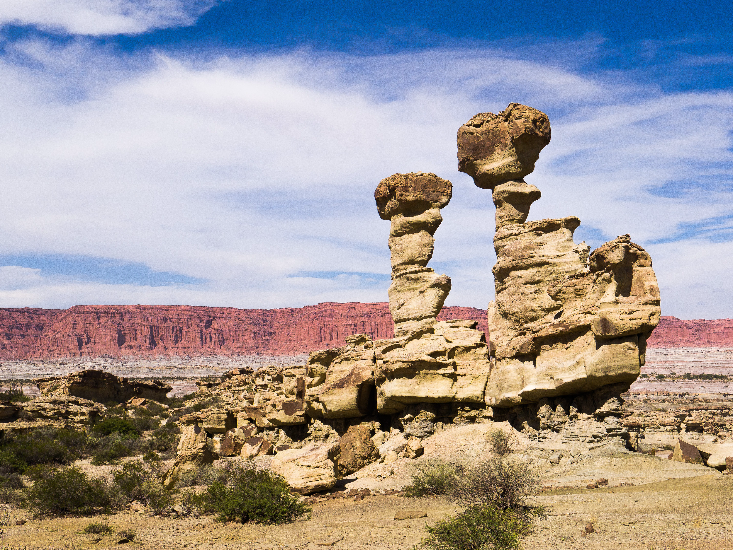
Two tan hoodoo rock formations stand tall in front of rocky terrain and a red canyon in the background

Ischigualasto Rock Formations. Rita Willaert. CC BY-NC-SA 2.0

Ischigualasto and Talampaya stretch over most of the sedimentary basin of the Ischigualasto-Villa Union Triassic, a geologic basin of great scientific importance which formed during the Triassic Period, approximately 250 to 200 million years ago. The basin contains a sequence of six layers of continental fossiliferous sandstone and mudstone sediments deposited by rivers, lakes and swamps, providing the world’s most complete and undisturbed picture of the geological history of the Triassic Period. 

The geological record helps us understand the evolution of vertebrate life and the nature of palaeoenvironments in the Triassic, the era that ushered in the Age of the Dinosaurs. Fossil records of at least 100 species of plants, 56 known genera and many more species of vertebrates, such as fish, amphibians, and a great variety of reptiles and direct mammalian ancestors, including the early dinosaur Eoraptor, have been found in the park. 

Two guanacos standing on a desert slope. The rock is red and sandy, with a variety of elevations and terrains

Guanacos, Ischigualasto National Park. Rita Willaert. CC BY-NC-SA 2.0

Radiocarbon dating suggests that humans occupied the area approximately 2,590-950 years ago. At Ischigualasto, six rock art sites have been discovered, along with burial sites, campgrounds and tool-making areas, as well as 1500-year-old petroglyphs (images carved into rock). The petroglyphs depict, among other things, geometric human figures, animals and a radiating sun figure. Animal and human footprints have also been found in the art, mainly puma, rhea and guanaco prints. 

A red, orange, and white striated canyon badlands. Larger green mountain hills in the distance

Valle della Luna. Guslight. CC BY-NC 2.0

One of Ischigualasto's main attractions is the Valle della Luna (Valley of the Moon). The valley, located near the provincial capital of San Juan, is famous for its unique and otherworldly landscapes. The valley is composed of rugged badlands of bizarrely shaped multicolored rocks and a floor of barren gray-white volcanic clay. Two hundred and thirty million years ago, the desert was a volcanically active floodplain, crisscrossed by rivers and subjected to seasonal heavy rainfalls. Petrified tree trunks more than 130 feet tall are a record of the ancient vegetation. These days the stark desert vista has sparse vegetation, xeric shrubs, cacti, the occasional tree and several rare species of flora and fauna. 

The Canon de Talampaya (Talampaya Gorge) is Talampaya’s main attraction. The red sandstone walls of the canyon and the surrounding cliffs reach up to 656 feet. The landscape has been deeply eroded by watercourses, a testament to the artistry of nature. These days the area is usually dry, but flash floods powerful enough to move large boulders have been known to strike the area.

A desert scene with large red mountain mesa in the background.

Ischigualasto National Park. Benjamin Dumas. CC BY-NC-SA 2.0

Before Spain began its conquest of South America, the area that now makes up the parks was inhabited by several groups of Indigenous people who lived as semi-nomadic hunters and gatherers, including the Diaguita and Huarpes.

The Ischigualasto and Talampaya Parks are more than just sites of great natural beauty. They are a journey into the history of this planet. Their spectacular geological formations, unparalleled scientific significance and cultural heritage have rightfully earned them a place on UNESCO’s list of World Heritage sites.

GETTING THERE

Fellow travelers recommend reaching the parks by taking an airplane to Villa Union, the closest neighboring city. From there you can rent a car, and it is about a 40-minute drive to Talampaya. You could also stay in La Rioja, which is about a 2-hour drive from the parks. Rough camping is permitted in the buffer zone at Ischigualasto Park, which has a small visitor center with an interpretive display, four toilets and a single ranger’s residence. Small buffet food services are available at both parks. Walking trails and interpretive signs are scarce. There are full-service facilities, lodging, commerce and medical care in the nearby towns of San Agustin in San Juan Province and Patquja and Villa Union in La Rioja Province. There are agencies in La Rioja and Villa Union that offer guided tours of the park.


Rebecca Pitcairn

Rebecca studies Italian Language and Literature, Classical Civilizations, and English Writing at the University of Pittsburgh. She hopes to one day attain a PhD in Classical Archeology. She is passionate about feminism and climate justice. She enjoys reading, playing the lyre, and longboarding in her free time. 

Festival de Tango: The Heartbeat of Buenos Aires

Every August, the annual Festival de Tango engulfs the streets of Argentina’s vibrant capital in mesmerizing tango dance, soulful music and rich Argentinian culture.

Two tango dancers on stage, the woman mid-jump, during a dance in the spotlight. A large screen behind them mirrors their image.

Performers at Festival de Tango in Buenos Aires, Argentina. Gobierno de la Ciudad de Buenos Aires. CC BY 2.0

From August 21 to September 1, 2024, the best tango dancers in the world are drawn to the Festival de Tango and the Tango World Cup in Buenos Aires, Argentina. Events during this time of tango span the entire city, offering easy access to travelers regardless of location. Festival-goers have many exciting activities at their fingertips. Beyond viewing the tango competition which features hundreds of world-renowned dancers, visitors can attend film screenings, theater, book readings, tours and more. 

As the birthplace of tango, Argentina is the best place to celebrate. Tango first appeared in bars and dance halls during the 19th century in immigrant communities throughout the Rio de la Plata region that stretches between Uruguay and Argentina. Tango began to globalize during the 1930s and has since become a worldwide phenomenon, with the United Nations recognizing the tango dance as intangible cultural heritage in 2009. 

Tango is a big part of Buenos Aires’ identity. The Festival de Tango began in 2003 as an initiative to increase tourism and cultural appreciation. Throughout the city, there are dozens of dance productions and live music performances. Participants can take it to the next level by becoming Tango dancers themselves at one of the many local Tango classes. Other staple events in Buenos Aires are Tango dance parties called milongas. Classes are often offered before milongas and can also be found at the many world-famous tango schools throughout Buenos Aires. 

For those who prefer listening over dancing, venues such as the Usina de Arte and CCK often host free concerts. To delve even further into tango history and culture, visitors can take a trip to the tango neighborhood called Boedo, which was immortalized in the tango song Sur by Homero Manzi. Many of the Festival de Tango events are free. However, because hundreds of thousands of people often attend Festival de Tango events, it is recommended to reserve space ahead of time or arrive early before activities hit capacity. 

Here are a few Festival de Tango activities to check out:

Participate in immersive tango packages offered by Argentina Tango: $1,659 to $7,245

Attend the Tango World Cup at the Usina del Arte: FREE

Watch tango performances over dinner at the Galeria Guemes Theater: $80

Go out for a tango night with locals with Immersion Tours: $65

Attend private dance classes at several locations throughout Buenos Aires: $35


Madison Paulus

Madison is a student at George Washington University studying international affairs, journalism, mass communication, and Arabic. Born and raised in Seattle, Washington, Madison grew up in a creative, open-minded environment. With passions for human rights and social justice, Madison uses her writing skills to educate and advocate. In the future, Madison hopes to pursue a career in science communication or travel journalism.

8 Surprisingly Vibrant Desert Destinations

Deserts are much more than the beating sun and rolling sand dunes we often picture. These eight destinations showcase the incredible natural beauty of the desert, from salt flats and chalk formations to mountains and glaciers. 

Though deserts are often thought of as just hot, dry expanses of sand, they come in a variety of climates and landscapes and hold some of the world’s most fascinating natural formations. Deserts “are areas that receive very little precipitation,” making them arid but not necessarily hot and sandy. Many deserts are mountainous, and others are large expanses of rock or salt flats. Though their arid environment makes water in deserts scarce, they are far from lifeless. Plants and animals, including humans, have adapted to desert life. One-sixth of the Earth’s population lives in deserts, which are found on every continent. 

These eight desert destinations range from freezing to boiling in temperature and are all unique, with their own attractions and plant and animal life. Each of these stunning deserts is worth a visit, and they may change your opinion of the desert as a stark, lonely place to one of beautiful landscapes blooming with culture, history and life. 

White and Black Deserts, Egypt 

Located just a few hours from Cairo, Egypt’s White and Black deserts are two stunning and underappreciated visitor attractions. The White Desert is located in the Farafra Depression, a section of Egypt’s Western Desert, and boasts some of the most unique geological landscapes in the country. Incredible wind-carved white chalk formations rise from the sand in the shapes of towering mushrooms and pebbles, giving the White Desert its name. The White Desert stretches over 30 miles, and the most visited area is the southern portion closest to Farafra. To the north of the White Desert is the Black Desert, where volcanic mountains have eroded to coat the sand dunes with a layer of black powder and rocks. In the Black Desert, visitors can climb up English Mountain and look out over the landscape. The Egyptian Tourism Authority recommends booking a tour to explore the deserts in depth, and travelers can even stay in the White Desert overnight. 

Joshua Tree National Park, California 

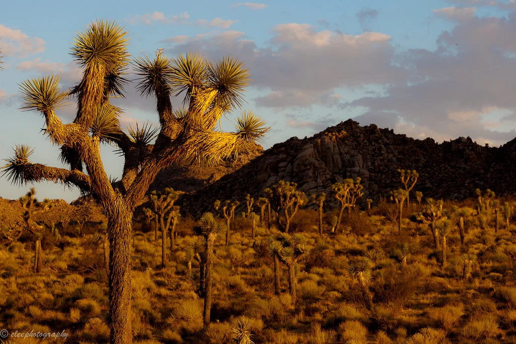
Joshua Tree National Park in Southern California is where two different desert ecosystems meet. Parts of the Mojave and the Colorado deserts are both found in Joshua Tree, along with a distinctive variety of plant and animal life. The Joshua tree, the park’s namesake, is the most identifiable of the plants, with its twisted, spindly branches and spiky clusters of greenery. Some of the park’s most popular attractions are Skull Rock; Keys View, a lookout with views of the Coachella Valley and the San Andreas Fault; and Cottonwood Spring Oasis, which was a water stop for prospectors and miners in the late 1800s. Joshua Tree National Park has roughly 300 miles of hiking trails for visitors to explore. The park is open 24 hours and can be visited at any time of the year, but visitation rises during the fall due to the cool weather and is at its height during the wildflower bloom in the spring. 

Atacama Desert, Chile 

Trips to the Atacama Desert in northern Chile are likened to visiting Mars on Earth. The dry, rocky terrain is so similar to that of Mars that NASA tests its Mars-bound rovers here. The Atacama Desert, the driest desert on Earth, spans over 600 miles between the Andes and the Chilean Coastal Range. Some weather stations set up in the Atacama have never seen rain. Despite its dryness, the desert is home to thousands of people, as well as plants and animals. People have been living in the Atacama Desert for centuries; mummies were discovered in the Atacama dating back to 7020 B.C., even before the oldest known Egyptian mummies. Attractions in the Atacama Desert include El Tatio geyser field, the Chaxa Lagoon, the Atacama salt flats, and sand dunes over 300 feet tall. The Atacama Desert is also said to have some of the clearest night skies in the world, making it perfect for stargazing. It is best to avoid a trip to the Atacama during the summer months, as the high temperatures make for a sweltering visit. 

Salar de Uyuni, Bolivia 

The world’s largest salt flat, Salar de Uyuni, covers 3,900 square miles in the southwestern corner of Bolivia. Salar de Uyuni is so large it can be seen from space and holds an estimated 10 billion tons of salt. Beneath the salt flat is approximately 70% of the world’s lithium reserves. This lithium is carefully extracted and used for powering laptops, electric cars and smartphones. Salar de Uyuni is surrounded by scenic lakes, geysers and rock formations, and is one of the world’s most beautiful and untouched natural landscapes. Tours of Salar de Uyuni take visitors to the Valley of Rocks; Morning Sun, which is home to geysers and mud pots; Colchani, a salt-processing village; and the Polques Hot Springs, where travelers can soak in warm thermal water. The landscape of Salar de Uyuni changes based on the seasons, so travelers should plan their visits around what they want to see. From July to October, access to all sites of Salar de Uyuni is unrestricted, but during the rainy season from December to April, visitors may be able to witness the salt flat’s famous mirror effect, where a thin layer of water over the salt transforms the land into the world’s largest mirror. 

Tanque Verde Ranch, Arizona 

Located just outside of Tucson, Arizona, near Saguaro National Park and the Rincon Mountains, Tanque Verde Ranch gives visitors “the ultimate dude ranch experience.” The ranch sprawls over 640 acres and stocks over 150 horses. Visitors to the ranch can get a real-life cowboy experience, including horseback riding and team penning. Riders of all experience levels will find something to do at Tanque Verde, where visitors can take beginning, intermediate and advanced lessons and then go on a sunrise or sunset trail ride through the Arizona desert. Tanque Verde Ranch offers kids’ riding activities too, as well as activities for non-riders such as yoga, mountain biking, fishing, swimming and pickleball. Visitors should pack long pants and closed-toe shoes if they plan to ride, and casual wear is appropriate for all non-riding times. Trips to the ranch usually last around four days, and visitors stay on the property. Tanque Verde Ranch is open to visitors year-round. 

Gobi Desert, Mongolia 

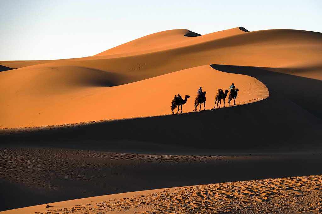
Spanning most of southern Mongolia and its border with China, the Gobi Desert contains stunning views and years of history. The region was once populated by dinosaurs, and some of the best-preserved fossils in the world were found near the Flaming Cliffs of Bayanzag. The Gobi Desert showcases a variety of natural beauty, from towering sand dunes to incredible white granite formations. Dry desert plants that come to life after rain make the Gobi unique, as well as ”saxaul forests” made up of sand-colored shrubbery. Visitors to the Gobi Desert should explore the Khongor Sand Dunes, an area that offers rocky and mountainous terrain in the south, dry and barren terrain in the center, and several oases in the north. Other major attractions are the Flaming Cliffs of Bayanzag, where red clay seems to glow in the sun, and the Gobi Waterfall, which looks like a city in ruins but is a completely natural formation. The best time to visit the Gobi Desert is either in late spring or in autumn, when the weather is neither too hot nor too cold.

Nk’Mip Desert, Canada 

Also called the Okanagan Desert, Canada’s Nk’Mip Desert contains the most endangered landscape in Canada. Located in Osoyoos in British Columbia, the Nk’Mip Desert Cultural Center is a 1,600-acre area of the Okanagan Desert managed by the Osoyoos Indian Band, and is the only fully intact area of desert in Canada. The desert is situated in a semiarid microclimate. The cultural center was designed to be eco-friendly and resembles the traditional winter homes of the Osoyoos Indian Band. Visitors can explore the desert on walking trails, which are surrounded by sage, prickly pear cactuses and antelope brush, as well as sculptures of desert creatures and native peoples by Smoker Marchand. The trails take visitors through a traditional Osoyoos village, where they will find a traditional sweat lodge and pit house. Many visitors prefer to explore Nk’Mip Desert in the summer due to the region’s relatively cold winters. 

Patagonian Desert, Argentina and Chile

The Patagonian Desert is South America’s largest desert and the seventh-largest in the world. It covers parts of southern Argentina and Chile, and is a cold desert, sometimes reaching a high temperature of 68 degrees Fahrenheit. The Patagonian Desert is home to two national parks: Torres del Paine National Park in Chile and Los Glaciares National Park in Argentina. Torres del Paine and Los Glaciares aren’t typical desert environments, but since the Patagonian is a cold desert, its landscape is different from that of most deserts. Before the Andes were formed, the Patagonian Desert was likely covered by temperate forests, so the region containing the desert, Patagonia, is extremely ecologically and geographically diverse. Torres del Paine National Park is known for its towering granite structures, which were shaped by glaciers. Los Glaciares is home to large glaciers, as well as scenic mountains, lakes and woods. The Cueva de las Manos, or “Cave of Hands,” is a series of caves in Argentinian Patagonia which are filled with paintings of hands dating back to 700 A.D., likely made by ancestors of the Tehuelche people. Tehuelche people live in Patagonia today, some still following a nomadic lifestyle. The best time to visit Patagonia is generally said to be in the summer (December to February), when the days are warm and the fauna is in full bloom, but there are merits to exploring the area at all times of year. 


Rachel Lynch

Rachel is a student at Sarah Lawrence College in Bronxville, NY currently taking a semester off. She plans to study Writing and Child Development. Rachel loves to travel and is inspired by the places she’s been and everywhere she wants to go. She hopes to educate people on social justice issues and the history and culture of travel destinations through her writing. 

Evo Morales Returns in Triumph to Bolivia, Ending a Year in Exile

One year after he stepped down amid a contested election, the popular left-wing leader is back. Will he be content with his supporters’ love, or will he seek power as well?

Evo Morales waving the Wiphala, a symbol for South America’s Indigenous people. Brasil de Fato. CC BY-NC-SA 2.0.

Exiled leaders rarely return so triumphantly. Evo Morales, president of Bolivia for 14 years before fleeing the country in November 2019, greeted a jubilant crowd when he crossed the border from Argentina and trekked to his home province of Chapare. Many expected a more forceful return, perhaps a march to the seat of government in La Paz. Rather, Morales traveled to where he started his political career at the precise moment when that career seems set to either end or begin again. 

If Morales plans to kick-start a new phase in his political career, he reenters in a much better position than when he started. Born to a poor family in the Orinoca region in 1959, his family moved with countless other families from the highland altiplanos to work on lowland coca farms, which provided poor Bolivians the best shot at a livable wage. The young Evo became a union leader, fiercely advocating for the rights of farmers when the United States’ war on drugs demanded the Bolivian government slash its supply of coca, its most profitable crop. In Bolivia, people chew on it or brew tea, but one ton of leaves can be refined into two pounds of cocaine base paste. 

A farmer pruning coca. Erik Cleves Kristensen. CC BY 2.0.

Morales’ experiences there fostered a brand of politics staunchly devoted to the poor and Indigenous communities through the institution of socialism. He joined and soon transformed the Movement for Socialism party (MAS) and became a one-term congressman. After leading violent street altercations that forced two presidents to resign, his ambitions expanded to the national realm. In 2006, the Bolivian people voted him in as president, beginning a 14-year-long tenure which would prove revolutionary.

For one, he was the first Indigenous president since the country’s independence in 1825. In a nation that is 42% Indigenous, this seems strange, but centuries of colonization and racism led to a society of haves and have-nots. An ethnic Aymara, Morales expanded MAS’s appeal to all Indigenous people, chafing many Whites and Mestizos who supported MAS in far fewer numbers. Some Indigenous communities found Morales’ embrace of Indigenous peoples hollow; he allowed drilling in forest reserves and expanded the amount of land settlers could clear. 

Man without a plan. Alain Bachellier. CC BY-NC-ND 2.0. 

Most of all, however, he presided over what many view as an economic miracle. Morales’ government reduced by two-thirds the amount of people living on less than $1.90 a day, the World Bank’s definition of extreme poverty. The high price of petroleum, another of Bolivia’s largest exports, allowed his administration to invest heavily in innovation and modernization. The widespread prosperity led many to ignore Morales’ authoritarian streak. He would often jail critics and journalists while piling lawsuits on his political rivals.

But when Morales ran for a fourth term against constitutional term limits, opponents found it unforgivable. A pause in vote-counting led many to believe he planned to rig the election, so thousands stormed the streets to protest the election results. Clashes broke out between pro- and anti-Morales protesters; 36 people died amid the violence. Once the military “recommended” Morales step down, he boarded a plane to Mexico and left Bolivia in the hands of little-known senator Jeanine Anez. 

She was a right-wing politician with exactly the opposite views of Morales. Where he proudly represented Indigenous peoples, Anez called them “savages.” (In his triumphant return, Morales sarcastically quipped, “The Bolivian right and the global right should know: the savages are back in government.”) Anez presided over an economic slump due to political unrest and COVID-19. She governed for 11 months before the electorate put in office Morales’ own protege Luis Arce.

Morales’ protege Luis Arce. Casa de América. CC By-NC-ND 2.0.

A bland, uncharismatic technocrat, Arce won broad appeal precisely because he was Morales’ choice. He engineered the economy during Morales’ presidency, so he can take credit for much of Bolivia’s prosperity. His support from the former president may prove both a blessing and a curse, however. He will struggle to distance himself from a controversial figure who still holds strong sway over MAS. His primary responsibility will be to maintain distance from Morales to the greatest extent possible.

For the time being, however, Morales will enjoy his warm welcome home. Crowds gleefully waved the Wiphala, a colorful checkered flag representing Indigenous peoples. Supporters dressed in their finest, most colorful Indigenous attire to celebrate his homecoming. Luis Arce neither met him in Chapare nor sent him a word of greeting. So far they hold no communication. For the sake of Bolivia’s democracy, many hope it will stay that way. 


Michael McCarthy

Michael is an undergraduate student at Haverford College, dodging the pandemic by taking a gap year. He writes in a variety of genres, and his time in high school debate renders political writing an inevitable fascination. Writing at Catalyst and the Bi-Co News, a student-run newspaper, provides an outlet for this passion. In the future, he intends to keep writing in mediums both informative and creative.

Argentina Times Two: Country Declares Rule over Antarctica—and the Falklands

The nation claims disputed territories in Antarctica. Will anyone notice?

A disputed no man’s land. Trey Ratcliff. CC BY-NC-SA 2.0.

Argentina recently doubled in size, according to Argentina. President Alberto Fernandez signed into law a 650,000-square-mile expansion of Argentinian territory from its southernmost tip to the South Pole, including maritime territory in between. Though the law was signed in August, its effects are just beginning to be felt. Next school year, Argentinian children will receive textbooks proclaiming their country to be twice the size it was when their parents went to school. 

The law’s legal reasoning is rooted in the United Nations Convention on the Law of the Sea, which provides President Fernandez a somewhat adequate basis for such an expansion. Argentina’s geographical shelf extends far into the sea, and the water is shallow enough to extend the country’s claim beyond the standard limit of 200 nautical miles from the nation’s coast. Though the move is grounded in international law, it has the potential to produce some controversy. 

Most strikingly, the law asserts what President Fernandez calls “Argentina’s claim to the Malvinas,” also known as the Falkland Islands. Fighting erupted between Britain and Argentina in 1982 when Argentina attempted to seize control of the Falklands, only to be rebuffed by Britain’s navy. While Britain still maintains control, most Argentinians support President Fernandez’s insistence that they have a rightful claim to the islands. 

Life on the ice. Christopher.Michel. CC BY 2.0.

For the time being, however, the conflict over the Falklands is as frozen as Antarctica itself. Other territorial spats are unlikely to occur. Since explorers began mapping the continent, numerous nations have claimed it as their own. International negotiations over land claims in Antarctica culminated in the Antarctic Treaty System in 1961. It provided freedom of scientific research for all nations and banned military activity, mineral mining and nuclear waste disposal. 

Argentina’s new waters offer much more than the snowy lands of Antarctica. Commercial fishing is lucrative just off the British-controlled island of South Georgia. There, fishermen enjoy prime access to abundant schools of Patagonian toothfish, icefish and Antarctic krill. While the COVID-19 pandemic has stopped most tourism, Antarctica contains myriad natural wonders for tourists strong-willed enough to endure the frigid temperatures. 

For now, disputed waters in Antarctica are unlikely to ignite any conflicts. The regions are sparsely populated and for the most part strategically unimportant. Even the Falkland Islands, the flashpoint of the war with Britain, has only 2,500 residents.

Scientific research at the end of the world. NASA Goddard Photo and Video. CC BY 2.0.

In fact, the brave few Argentinians who currently live in Antarctica enjoy a unique perk: safety from the coronavirus. The 400 people from the country in Antarctica reside on the only continent without a single case of COVID-19. These scientists and soldiers conduct scientific research but with far less staff than in prior years. To prevent the spread of the virus, Argentina opted to send only 400 researchers rather than the usual 2,000. Every person sent will take a test and quarantine before traveling to Argentina’s facilities, and since they won’t have many medical resources, people will be evacuated at the first sign of infection. Argentinian researchers can rest assured, though, that their president believes they tread not on a foreign continent but on their own home turf.


Michael McMarthy

is an undergraduate student at Haverford College, dodging the pandemic by taking a gap year. He writes in a variety of genres, and his time in high school debate renders political writing an inevitable fascination. Writing at Catalyst and the Bi-Co News, a student-run newspaper, provides an outlet for this passion. In the future, he intends to keep writing in mediums both informative and creative.

5 Spots for a Uniquely Uruguayan Experience

Uruguay is sandwiched between Argentina and Brazil, has a population of just over 3.5 million, and is home to miles of coastline facing the Atlantic Ocean. Although the climate is fairly mild throughout the year, the warmer summer months are when the tourist attractions really come alive. Uruguay pairs a generally laid-back culture, full of food and art, with trendy nightlife. Visitors can also venture away from the cities to more rural areas and explore an expansive countryside. Given Uruguay’s diverse landscapes and activities, any visitor is sure to have a memorable experience.

A view of the Rambla and the Montevideo skyline. Marisali. CC BY-NC-ND 2.0

Montevideo

Montevideo is the largest city in Uruguay as well as the capital. With a vibrant art scene and culture, Montevideo is an exciting place to explore. You can take a walk down the Rambla, a 14-mile boardwalk that offers an unobstructed view of the ocean as you wind through various neighborhoods in Montevideo. If you want to go to the beach, visit the Pocitos neighborhood, which is known for its beach and hosting nautical events throughout the year. In the Old City, tour the Solís Theater, a grand performance venue designed in a neoclassical style that echoes many of the other European-influenced buildings across the city. If you are craving a bite to eat stop by the Mercado del Puerto (Port Market), a hub of restaurants, cafes and shops overlooking the water. This is a great place to try eating at an Uruguayan parrilla, or wood-fired barbecue. 

La Mano in Punta del Este. Gamillos. CC BY-SA 2.0

Punta del Este

Two hours away from Montevideo is Punta del Este, a trendy summer spot and a popular escape from the bustling city. Punta del Este has expansive beach access, some of which are rougher and face toward the ocean (such as Playa Brava) while others are calmer and preferred by those with young families (like Playa Mansa). At night, people can go out to bars, restaurants and clubs all over the city, where events can go on until the sun comes up. If you’re interested in a sleepier part of town, visit José Ignacio, a seasonal fishing village to the east. The national dish of Uruguay, the chivito, originated in Punta del Este. You would be remiss if you did not take a moment to sample a chivito (a beef sandwich with a variety of toppings such as cheese, egg and tomato) while visiting. For a taste of the arts, you can visit the iconic hand sculpture, crafted by Chilean artist Mario Irarrázabal, or the gallery and sculpture park of renowned artist Pablo Atchugarry

An old building in Colonia del Sacramento, Uruguay. DiegoOlivera_Uy. CC BY-NC 2.0

Colonia del Sacramento

A city with Portuguese roots, Colonia del Sacramento looks across the Rio de la Plata to Buenos Aires, Argentina. The cobbled streets of the Barrio Histórico are popular with visitors and this part of the city is labeled a UNESCO World Heritage Site. To enter this part of town you will cross a drawbridge of a former fortress. Notable landmarks include the Basilica of the Holy Sacrament, Convent of San Francisco, Calle de Portugal and the Colonia del Sacramento Lighthouse. This city will appeal to a wide range of visitors, from historians to vintage car enthusiasts.

Grapes hanging from the vine. UGA CAES/Extension. CC BY-NC 2.0

Wine Country

While in Uruguay, consider visiting one of many vineyards scattered across the country. Uruguay produces a variety of wines, but its signature red wine is called tannat. Although the wine originated in France, the Uruguayan version is considered to be softer due to the warmer climate. Many wineries will allow visitors to sample their wine and tour the grounds. You can visit popular wineries such as Bodega Bouza and Alto de la Ballena or organize a wine tour so you can experience a wide selection. Enjoy a glass while taking in the scenic Uruguayan landscapes.

Gauchos practicing in the countryside. Nicoyogui. CC BY-NC 2.0

Gaucho Country

Another part of Uruguayan culture worth learning about is gaucho culture, which was formed around the romanticized idea of a horse riding hero of the land who cannot be tamed. One standout detail of gaucho culture is the drinking of yerba mate, a bitter tea one drinks from a modified gourd. While the traditional gaucho is no longer as prevalent, modern-day gauchos can be found working on estancias, cattle ranches that can span hundreds of acres. With meat, especially beef, a major component of the Uruguayan economy, these estancias are extremely important. Nowadays, some gauchos have joined the tourist industry in Uruguay and are open to hosting visitors or providing guided rides where they can educate others about their culture. 

Phoebe Jacoby

is a Media Studies major and Studio Art minor at Vassar College who believes in the importance of sharing stories with others. Phoebe likes to spend her free time reading, drawing, and writing letters. She hopes to continue developing her skills as a writer and create work that will have a positive outward effect.