The Culture and Conservation of Myanmar’s Inle Lake

Inle Lake is home to communities based entirely around the water, while fears of ecological damage have locals and conservationists concerned.

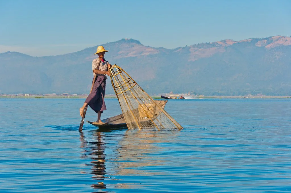
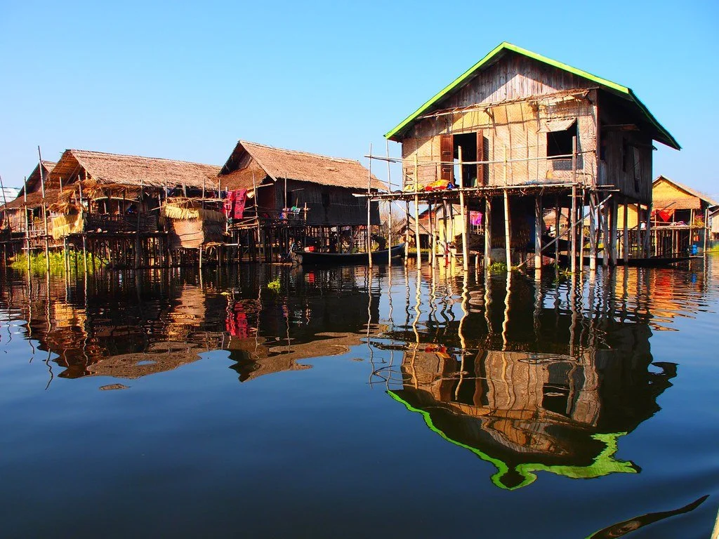
Inle Lake, positioned between mountains in Myanmar, is home to 17 different villages with unique cultures and traditions. Inle lake is the second largest lake in Myanmar, roughly 14 miles long, and is in the center of the Shan state. The lake is populated by the local Intha people, whose livelihoods are developed around the water. Bamboo houses are built on stilts above the water, to allow plenty of airflow in the humid environment. Additionally, the stilt houses add the advantage of flood protection, letting the water flow between dwelligns. Locals rely on water transportation, making the stilted houses perfect for boat access. Another notable unique aspect of Inle lake is the style of paddling fisherman use, curving on leg around the ore while standing in the boat. 

Daily life on Inle lake is centered around the water, including their gardens. Locals grow floating gardens that are made of reeds and other plants. The gardens are floating (and not on stilts, like many of the structures are on the lake), making them very resistant to floods. The gardens are used for growing vegetables, especially tomatoes, due to the climate. Locals use the gardens for personal produce and to sell the vegetables they grow as a source of income.

A popular textile of the region comes from lotus weaving, a tradition that many local women take part in. The villages Kyaing Khan and In Paw Khon are considered centers of lotus weaving. However, women all around Inle Lake create textiles from lotus weaving. Women started the practice roughly 100 years ago, weaving textiles from lotus flowers that grow on the lake. 

Of the communities on the lake, Ywama Village is one of the most well-known, specifically for its floating market. The market is held every five days and is made up entirely of vendors and customers in boats. The market includes everything from vegetables and fish to clothing.Ywama also is home to an important religious site on Inle lake, the Phaung Daw Oo pagoda. This Buddhist monastery houses five images of the Buddha that were brought to the area in the 12th century. The images have been continuously covered in gold leaf, to the point where the images of the Budhha are completely covered. Buddhists visit the monastery and apply gold leaf as a sign of respect, leading to layers upon layers of gold. Every year a festival takes place during the month of Thadingyut (October/ November), which consists of boats carrying the images of the Buddha to the different villages on the lake. The festival is 18 days long, and each boat stops at each village for a night. Unfortunately, in 1965, a boat capsized during the festival, and one of the images was lost in the water. The image was then miraculously found back in the pagoda. Since then, it has remained in the pagoda even during the festival.

While Inle Lake has a thriving culture and a long history, there are fears about Inle Lake’s long-term conservation, as the region has experienced several droughts, including a severe one in 2010. Soil erosion, deforestation and pesticides in the water are some of the main concerns for conservationists. The Ministry of Environmental Conservation and Forestry partnered with UN-Habitat in 2011 to create a plan to conserve Inle Lake in response to the significant drought the year before. Additionally, the main concern was that the heavy inflow of tourists caused an increase in the use of motorboats that resulted in more spillage and contaminated the water. In 2018 the United Nations Development Program launched an initiative to draft a law through local and state governments to conserve the lake. By February 2019, the Conservation Law was passed and is considered a major step forward in the conservation process. Inle Lake is a UNESCO Man and Biosphere Reserve. It is widely acknowledged as an important cultural and ecological place to preserve.

Despite being isolated from other major tourist attractions in Myanmar, Inle Lake still has travelers visiting at an increasing rate. Roughly 20 miles from the closest airport, the roads to Inle Lake can be long and rough. The fastest route is to fly to Heho, but some visitors drive the long hours from Bagan, Mandalay, Thazi or Kalaw. Once you arrive at  Inle Lake, there are hotels available that cater to travelers.  In addition to the long journey to Inle Lake, high levels of unrest and conflict due to the military taking control in a coup in early February 2021 makes travel in the region difficult. Many have fled Myanmar after the coup, and the potential danger has made travel in the area unadvisable.


Dana Flynn

Dana Flynn is a recent graduate from Tufts University with a degree in English. While at Tufts she enjoyed working on a campus literary magazine and reading as much as possible. Originally from the Pacific Northwest, she loves to explore and learn new things.

3 Asian Theatrical Traditions

The cinema may be the world’s most prominent entertainment, but recorded film screenings cannot match the liveliness of performing theater. Learn about three theatrical traditions beloved by their Asian audiences for their craftsmanship and cultural significance.  

Stage Theatre. AndyRobertsPhotos. CC BY 2.0.

Theater is a unique art in its ability to elicit both laughter and tears within the same showing. Throughout these three Asian nations the stage is a place where performers can bring imaginary worlds to life, or inspire their audiences to better their own.  

1. Japan’s Rakugo

Rakugo. Isabelle + Stephanie Galley. CC BY 2.0.

Rakugo (fallen words) showcases a storyteller’s skill to enthrall their audience without the use of any costumes, scenery or special effects. Rakugo was developed during Japan’s Edo Period (1603-1868) by Buddhist priests who recounted dramatic tales to illustrate the impermanence of life and the sufferings elicited by materialistic attachment. Soon non-religious performers regaled crowds with parodied interpretations of those parables. A specialized sect of storytellers has emerged since, termed the rakugoka, who rely upon improvisation, exaggeration and, most critically, wordplay for their performances. A rakugoka presents upon the spartan kōza stage while dressed in traditional Japanese garb, and has only a sensu (paper fan) and a tenugui (hand towel) as props to aid them. With pantomime, voice and facial expressions the rakugoka will narrate one of 300 stories inspired by the realities of ordinary people.

The stories of rakugo are structured as back-and-forth dialogues between a set of archetypal characters and generally culminate in a funny climax. Popular character archetypes include cunning tricksters, miserly merchants, arrogant authorities and kaidan (ghosts or other apparitions). Each narration ends with an raku (fall), a humorous linguistic twist which serves as a punch line for the whole performance. Rakugo is analogous to a one-man show of sit-down comedy. 

2. India’s Nukkad Natak

Nukkad Natak. DLF PUBLIC SCHOOL, INDIA. CC BY 2.0.

From universities to slums throughout India, nukkad natak (street drama) serves as a medium of entertainment as well as social commentary. India has a rich heritage of theater which traces back centuries, but nukkad natak was shaped very recently among the country’s schools and streets. In the 1980s, left-wing grassroots activists started to put on plays for the lay public to highlight major social and political issues. Nukkad natak grew especially popular among college students who identified an outlet through which they could express their unacknowledged emotions and views. Nukkad natak has since become a channel for communication and information among the uneducated masses. 

Without any audiovisual equipment or cosmetic crew professionals nukkad natak troupes are forced to capitalize their bodies to the fullest. The troupers’ voices vary in pitch and volume as they undertake in constant physical motion. Troupes will not shy away from controversial scenes like sexual assault but will act them out publicly to provoke emotions. Some troupes dedicate their performances towards the portrayal of exemplary civic behavior. Even India’s private sector recognizes nukkad natak’s enormous influence on public society; some multinational corporations sponsor their own performances to advertise their products.   

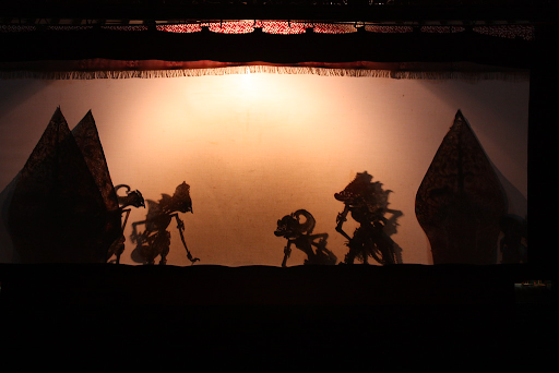
3. Indonesia’s Wayang Kulit

Yogyakarta, Wayang Kulit. Arian Zwegers. CC BY 2.0. 

Although its origins are disputed to date, there is no debate as to the renown wayang kulit (shadow leather) holds today in Indonesia and neighboring countries. Intricately detailed leather puppets are deftly maneuvered by a dhalang (puppeteer) between a light source and a blank screen to portray a story via shadow. Performances feature plots derived from a bevy of sources, ranging from Hindu epics such as the Ramayana or Mahabharat to the East Javanaese Prince Panji cycle. 

A show of wayang kulit may carry on through the night for eight hours and is usually accompanied by a gamelan bronze orchestra. A single performance may entail the use of hundreds of puppets, all of whom are designed with utmost faithfulness to visual symbolism. Puppets portraying noble heroes, for example, are crafted in accordance with the Javanese ideal of male beauty: slender build, long and pointed nose and eyes shaped like soya beans. A puppet’s colors represent characteristics; gold indicates dignity whereas white is the color of youth.


RELATED CONTENT:


Rohan A. Rastogi

Rohan is an engineering graduate from Brown University. He is passionate about both writing and travel, and strives to blend critical thinking with creative communication to better understand the places, problems, and people living throughout the world. Ultimately, he hopes to apply his love for learning and story-sharing skills to resolve challenges affecting justice, equity, and humanity.

The Smallest Country in South America: Suriname

The nation of Suriname is home to a multicultural society and the Amazon rainforest. Yet, little is known of the country as it attempts to stand out behind the shadows of its former Dutch colony. 

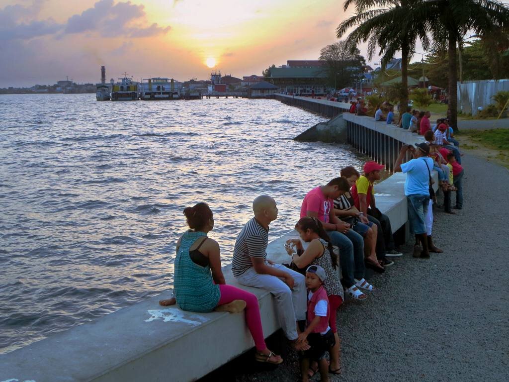
Suriname River Waterfront. D-Stanley. CC BY 2.0

When one thinks of South America, one thinks of all the Spanish-speaking countries. However, rarely do you think of The Guianas, the three countries in the northern part of the continent: Guyana, Suriname and French Guiana. The smallest nation of the three is Suriname, and it covers a surface area of 63,252 square miles. Known as a former colony of The Netherlands, Suriname gained its independence in 1975. This Dutch-speaking nation is surrounded by 94% of pristine forest and has a multicultural society. 

Suriname is named after its first occupants, the Surinen Indians. However, in 1602 the Dutch settled in the region, and by 1667 it became a colony of the Netherlands. Throughout the Dutch’s settlement in the nation, many important events made Suriname the country it is today. After the termination of slavery, the Dutch brought in East Indian laborers. The Netherlands granted Suriname its independence on November 25th, 1975, when the Surinamese people rioted over inflation and unemployment. Fast forward to today, the country is a constitutional democracy

In addition, Suriname is struggling with seven in ten people falling below the poverty line. The Surinamese rely heavily on the exportation of gold and other minerals, accounting for 85% of exports and 27% of government revenues. Agriculture is also a big part of their exportation, which includes bananas, rice and shrimp. With poverty taking a toll on its people, there has been an upside to their current financial situation. The country will begin producing oil in 2025, appealing to prospective investors. The government holds 13 billion barrels of oil and gas that have been discovered in the past six years. With this finding, financial stability can emerge for the Surinamese. At the moment, Suriname produces oil for domestic use and its own oil company Staatsolie

Surinam youth. KITLV Collections. CC BY-NC 2.0

With the history Suriname has lived through, it is no surprise that it is a multicultural nation. It is made up of South Asians (Indians), Maroons, Suriname Creole(Afro-Surinamese), Javanese, biracial and others. 

Even ith this diverse and integrated culture that makes up Suriname, citizens of this nation  live peacefully among one another. So much so that a Jewish temple and a Muslim mosque sit side by side in the capital city of Paramaribo. This cohabitation can be seen as the entire country officially marks other nations’ religious and nonreligious holidays as their own. . These holidays include Chinese New Year, Easter, Indigenious Peoples Day, Maroons day, Idul Adha and Deepavali. Through this act, the nation exemplifies unity through its melting pot of diversity. 

With any diverse culture comes an eccentric music genre. Through the music, one can hear the different backgrounds of each region represented. Suriname’s music style is no different. It is a mixture of International European, North American indigenous and South American rhythms. One of the Surinamese most well-known music forms is Kaseko. It is a fast-paced beat with Indo-Caribbean influence, which emphasizes wind instruments and percussion. 

The nation’s cuisine is quite diverse as well and is a big part of the Surinamese culture. However, there is a dish that they call their own, which is Pom, the National dish. The name Pom is short for pomtajer, the root vegetable used to top the dish. Pom is a casserole made up of root vegetables and your choice of meat. This dish is a luxury, usually served on special occasions due to the high cost of meat.  

Muslim Temple and Jewish Mosque sitting side by side. Dan Lundberg. CC BY-SA 2.0

There are many influences in the country’s buildings and architecture today. With all of the ethnicities and cultures that inhabit Suriname, it is no surprise it would spill over onto the design of the city. Made up of mostly wooden buildings, the style and design seem to have stayed rooted in a specific time period. There are no contemporary buildings, and that is what makes the city so enchanting. Throughout Suriname you can see the fusion of Dutch, North American and Creole culture and others in the architectural style

On the outskirts of the city sits more than 90% of lush green forest, the Amazon. With such vast greenery, this forest is home to 150 species of mammals, 650 bird species and 350 fish species. With such a large part of the forest being untouched and preserved, Suriname species don’t face extinction like other species around the world. This is due to the capacity of the land makes it easy to house the numerous species. Nature enthusiasts visit the various nature reserves Suriname has to offer. The largest and most popular is the Central Suriname Nature Reserve at 1.6 million hectares; it protects the upper watershed of the mighty Coppename River and other important rivers. The reserve’s animals include sloths, jaguar, tapir, eight species of primates and others. 

Sunset in the Suriname rainforest. Delphinidaesy. CC BY-NC-ND 2.0

This small nation is home to slightly fewer than 600,000 people. Although mostly unknown to many, Suriname is slowly bringing in many travelers worldwide. Its unique landscape and culture are admired and it is sure to attract many more travelers in the years to come. Suriname is making a name for itself on the world map with so many species to see and nature reserves to explore. 


RELATED CONTENT:


Jennifer Sung

Jennifer is a Communications Studies graduate based in Los Angeles. She grew up traveling with her dad and that is where her love for travel stems from. You can find her serving the community at her church, Fearless LA or planning her next trip overseas. She hopes to be involved in international humanitarian work one day.

15 of the World’s International Dark Sky Sanctuaries 

The star-filled night sky is one of the greatest natural wonders, but it can be hard to see these days due to light pollution. Therefore, the ultimate places for stargazing are “Dark Sky Sanctuaries”, some of the most remote and dark places where the night sky is perfectly visible. Check out these 15 spots.

Read More

Tapas Bars in Andalucía Continue Spanish Traditions

Spanish tapas started as simple small plates to accompany a drink and are now an important part of Spain’s culture where people gather for food, drinks and socializing.

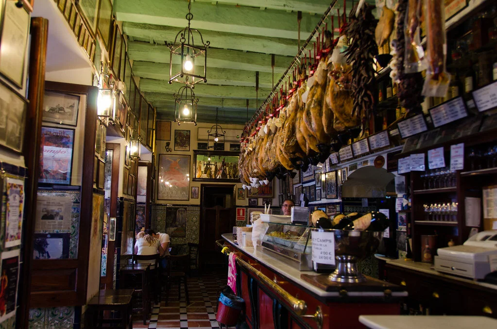
Bar Las Teresas in southern Spain. VallausaCC BY 2.0

Tapas bars are a long-held Spanish tradition that includes traditional food, wine, friends and a lively atmosphere. The small plates have been enjoyed at wine bars for generations, but the exact origin of tapas is unknown. There are several tales speculating how the dishes first gained popularity. One dates back to the 13th century when King Alfonso X of Castille was ill and only ate and drank in small quantities. Another story tells a more grassroots origin, with local bars in Andalucía serving wine with a saucer on top to keep flies out during the hot summer. In addition, a small amount of complimentary food would be placed on the plate to attract more customers to the bar. Even though there may be some disagreement over the origins of tapas, there is no doubt that the cuisine is a staple of Spanish food and culture. With increased tourism and popularity, most tapas are no longer free, although some wine bars still will serve complimentary tapas in smaller towns in Andalucía.

Tapas bars are typically small wine bars, with varying small plates placed on top of the bars. While many tapas may have started out as simple small plates,  chefs have gotten increasingly inventive in creating new dishes over the years. Traditional cold tapas include serrano, thinly sliced salt-cured ham and manzanilla or gordal olives, classic Andalucía olives, along with a variety of salads. Seafood is prevelant, with calamari and prawns dipped in batter, called gambas gabardina, being just a few dishes offered at tapas bars. Other popular tapas include ham croquettes (a fried ball of cheese and ham), pincho de tortillas (a potato-based omelet) and patatas bravas (fried potatoes covered in sauce).

Tapas bar hopping is popular for people to socialize and enjoy traditional food. People can have tapas as a quick snack with a drink and can eat standing up at a bar, or turn the small plates into a complete meal with many people. Tapas hold so much cultural significance to Spain that in 2016 the country sought to put tapas on the UNESCO Intangible Cultural Heritage List. Tapas have now spread worldwide with chefs experimenting with small plates of all kinds. Despite the global reach, Spain’s beloved tapas bars are still a unique cultural experience.


RELATED CONTENT


Dana Flynn

Dana is a recent graduate from Tufts University with a degree in English. While at Tufts she enjoyed working on a campus literary magazine and reading as much as possible. Originally from the Pacific Northwest, she loves to explore and learn new things.
3 Cliffside Communities and Underground Towns

Towns throughout the world strive for connection with their natural environment. Here are three which built very close relationships with local geology.

 Hotel Sidi Driss, Matmata. Scottroberts. CC BY 2.0 

Venice may be renowned for its aquatic urban planning, but it’s not the only place making resourceful use of its surroundings. Learn about the following three settlements whose residents literally live under a rock (or two). 

1.     Setenil de las Bodegas, Spain

Biking street in Setenil de las Bodegas. Kans1985. CC BY 2.0

In Southern Spain lies Setenil de las Bodegas, a town carved into towering bluffs of rock. The rocky cliffs are remnants of a canyon gorge eroded by the river Rio Trejo and were first developed for residence by the Moors in the 12th century. They built houses directly into cave walls to provide inexpensive, temperature-regulated dwellings at minimal risk from disasters such as earthquakes or wildfire. With expansive rocky overhangs serving as natural roofing, these houses are materially efficient and easy to maintain. The three thousand inhabitants of Setenil de las Bodegas take pride in local history; the town is named after seven battles fought by Catholic Spaniards against the Moorish rulers during the Reconquista. The Moors maintained their defensive stronghold throughout six attempts but were defeated by the Catholics on the seventh.

Visitors may tour the town’s Nazari castle, an Arabian fortress dating back to the Almohad Caliphate, and the signature church of Our Lady of the Incantation. In addition, Setenil de las Bodegas offers several restaurants and bars for visitors to sample among its stony streets; dine upon the traditional local delicacy sopa cortijera, a wild asparagus soup enriched with boiled eggs and chorizo.

2.     Matmata, Tunisia

Troglodyte house. Professor Mortel. CC BY 2.0

Just across the Mediterranean Sea, Berber descendants populate the town of Matmata, iconic for its traditional subterranean dwellings. Historians are uncertain about when these troglodytes first emerged; settlement may have occurred as early as the 11th century or as late as the 15th. The Berbers excavated clay from underground pits to form cool spaces within which they could evade the dry heat of the Matmata valley. Deep, circular pits were dug into the sandstone ground and hollowed out. The troglodyte spaces were subsequently dug out around the pit’s perimeter, leaving the central pit as a courtyard. Sandstone clay was soft enough to excavate by hand but would harden rapidly upon exposure to air. Such underground homes were sturdy but vulnerable to flooding; during the 1960’s Matmata were forced to evacuate due to extreme rains.

Visitors may immediately recognize Hotel Sidi Driss, the site selected by George Lucas to film Luke Skywalker’s childhood home on the planet of Tatooine, within Matmata. Hotel Sidi Driss operates to date, boasting twenty rooms, a hotel restaurant, and Star Wars decorations in homage to its movie history. 

3.     Coober Pedy, Australia

The underground church in Coober Pedy. www.wbayer.com. CC BY 2.0

In Australia’s outback, Coober Pedy is a storied subterranean town situated at the edge of the Great Victoria Desert. The town originated from the discovery of opal reservoirs in 1916 and soon became a premier mining community. Miners moved to Coober Pedy to try their luck at burrowing for gemstones but found extreme temperatures more often than opals. To deal with the dry summer heat, which can exceed 100 degrees Fahrenheit, miners started to sleep and eat in the mines. It wasn’t long before miners decided to dig out proper buildings from sandstone to reside in. Currently, Coober Pedy boasts public museums, libraries, churches, bars, a drive-in theatre and even a swimming pool,—all underground.     

But the ‘Opal Capital of the World’ has cause for another claim to fame: ‘Hollywood of the Outback.’ Coober Pedy is renowned for science fiction filmography due to its extreme environment and barren landscapes. Hardly any vegetation grows natively; Coober Pedy’s tallest tree used to be a sculpture of scrap metal before townsfolk planted seeds. Moviemakers have flocked to Coober Pedy to leverage the area’s uncanny resemblance to other planets. “Mad Max: Beyond Thunderdome,” “Pitch Black,” “Red Planet” and “Until the End of the World Planet” are some sci-fi films shot in Coober Pedy.


Rohan A. Rastogi

Rohan is an engineering graduate from Brown University. He is passionate about both writing and travel, and strives to blend critical thinking with creative communication to better understand the places, problems, and people living throughout the world. Ultimately, he hopes to apply his love for learning and story-sharing skills to resolve challenges affecting justice, equity, and humanity.

Nazaré, Portugal: How A Fishing Village Became a Surfing Mecca

For centuries, Nazaré, Portugal was a traditional fishing village; until it made its way on the big wave surfing map. Now, it’s what many consider to be the Mecca of surfing, drawing crowds from across the globe. 

Historically, big wave surfers gravitated towards the waves found in the surfing communities of Hawaii and California. Locations like Jaws, Mavericks, Shipstern Bluff and Mullaghmore were thought of as the best of the best. However, it wasn’t until recently that Nazaré, Portugal made its name as a surfing destination. Nazaré’s beach of Praia do Norte has all the elements for disaster—a deep underwater canyon and currents of waves that collide into one, breaking towards the coast of monumental cliffs. Surfing there, in the winter especially, was long thought to be impossible. It wasn’t until 2010 that someone was daring enough to surf the uncharted waters and alter the history of Nazaré forever. 

Just a few meters off the shore of Praia do Norte is the Nazaré Canyon, an underwater submarine valley 3 miles deep. When water currents move through the valley, they get compressed and begin to move faster. When these currents collide with the local water current, they forge waves upwards of 10 stories high. Among villagers, the waves in Praia do Norte were forbidden. Many had loved ones who died at sea, and they taught their children to avoid the huge waves. So in 2010, when Garret McNamara first arrived, locals were apprehensive about getting behind him and his mission to ride a 100-foot wave.  

It took five years for McNamara to take up an invitation from Dino Casimiro, a local bodyboarder who worked to publicize Nazaré’s waves. When he first laid his eyes on the view from the cliff, he told The New York Times, “it was like finding the Holy Grail.” He’d spend the next year preparing, studying the rhythm of the waves, and developing a safety system with his team of jet-ski tow-riders and spotters on walkie-talkies. Finally, in November of 2011, McNamara conquered a 78-foot wave, earning him a Guinness World Record, and serving as proof that Nazaré’s waves were real and surfable. From that moment on, every big wave surfer in the world wanted their shot to make a name for themselves at Nazaré. Today, at least 20 professional surfers stay in Nazaré during any given week in the winter, including men and women like Justine Dupont, Lucas Chianca, and Kai Lenny. 

In 2013, the town’s current mayor Walter Chicharro was elected. Chicharro worked with McNamara and Casimiro to capitalize on their waves’ fame and invested in the professionalization of the surfing scene. The World Surf League now hosts an annual big wave surfing challenge event every winter, a time that Nazaré’s 10,000 locals were accustomed to having to themselves. In additon, Mayor Chicharro opened the town’s 17th-century lighthouse, Farol Da Nazaré, both as a museum showcasing the town’s history and as a space to view the waves. According to an article in The New York Times, about 40,000 people visited it in 2014, while more than 220,000 entered the fort in 2018. 

Today the town is used to the presence of surfers; even the local fisherman welcome them thanks to the business they bring. Joao Carlines, a retired fisherman, told reporters that “Surfers have a different relationship with the sea, but I’m happy the town’s become known for surfing because it means we have people coming here in the winter.” While the elusive 100-foot wave has yet to be ridden, rest assured that it will be one day, and it will be in Nazaré. In anticipation of that day, surfers and their fans will continue traveling to the seaside village in hopes of witnessing the historic event for themselves.  


Claire Redden

Claire is a freelance journalist from Chicago, where she received her Bachelor’s of Communications from the University of Illinois. While living and studying in Paris, Claire wrote for the magazine, Toute La Culture. As a freelancer she contributes to travel guides for the up and coming brand, Thalby. She plans to take her skills to London, where she’ll pursue her Master’s of Arts and Lifestyle Journalism at the University of Arts, London College of Communication. 

Hut-to-Hut: Hiking in the Italian Dolomites

Mountain Huts, called Rifugios, make multiple day treks through the Italian Alps accessible to hikers.

Puez-Geisler nature park in the Dolomites. Dmitry Djouce. CC BY 2.0

The mountain range located in northern Italy has 18 major peaks and uniquely diverse mountain landscapes. The Dolomites have sharp peaks in varying shapes, along with alpine meadows and valleys that have drawn hikers for years. Mountain huts, also known as rifugios, are placed throughout the Italian mountain range, all within a day’s hike of the next hut. The trek to visit each hut is a total of 75 miles, and typically takes hikers ten days to complete. The huts are stocked with food, and offer basic bedding for travelers. While not every rifugio offers places for hikers to stay overnight, many only serve food, so travelers can stop for lunch before continuing to the next hut. The huts allow hikers to do multiple day-treks without having to pack much. All they will need is personal items and sleeping bag linings. The rifugios are open starting in June and often draw travelers of varying hiking experience.

The Dolomites first started attracting hikers during the ‘golden age of mountaineering’ in the late 19th century. Many mountaineers who first summited the peaks wrote early travel guides for the region, drawing more explorers. Then, in World War One, the Dolomites became the front line for the Italian and Austro-Hungarian armies to pass through. As a result, there are still visible remnants of the war, one being an open-air museum of Mt. Lagazuoi. The ‘castle of rock’ has complex systems of tunnels dug into the mountainside during the war. The tunnels are open for people to walk through and learn more about World War One’s impact on the region. 

Additionally,a museum is dedicated to World War One on the range’s highest peak, Marmolada. The summit stands at over 10,000 feet, making the museum the highest in Europe. The locals of the region often speak Italian, German and Ladin, a Rhaeto-Romaniclanguage that is recognized as an official language of the region. Roughly 30,000 people speak Ladin, and there are considerable efforts to preserve the region’s language and the culture.


Dana Flynn

Dana is a recent graduate from Tufts University with a degree in English. While at Tufts she enjoyed working on a campus literary magazine and reading as much as possible. Originally from the Pacific Northwest, she loves to explore and learn new things.

5 Cities To Visit Before They’re Underwater

Rising sea levels are slowly swallowing some of the world’s most exciting cities. Even with defensive measures in place, and immediate cuts to carbon emissions, these levels will continue to rise. 
In the twentieth century, climate change has driven global sea levels up by 11-16 cm. Even with immediate cuts to greenhouse gas emissions, the average global sea level will likely rise at least one foot above those reported in the 2000s. Under high emission scenarios, the UN claims that ocean levels may approach or exceed 2 meters in the case of early-onset Antarctic ice sheet instability. 

Although it won’t happen instantly, these increases will be irreversible at a temperature rise of 3C. As a direct side effect, the rising oceans threaten to erase some of the world’s greatest cities. The longer actions go without being taken, the less time people have to experience these locations as they’re known and loved today.   

1: Rio De Janeiro

In the past few years, the coastal city of Rio de Janeiro has experienced extreme precipitation and deadly floods. The city’s poor drainage infrastructure stands small to the combined effects of heavy rainfall and sea-level rise caused by climate change. Despite efforts by the city government, projections show Rio’s famous beaches, including Copacabana, the waterfront domestic airport and the Barra de Tijuca neighborhood, where they hosted the Olympic Games in 2016, will be underwater by the year 2100. According to The Sao Paulo Research Foundation (FAPESP), 60% of the city’s population lives within 60 km of the coast. Flooding of the areas could mean the displacement of 1.8 million people and cost jobs and businesses that rely on tourism brought by Rio’s coast of beach destinations. 

2: Shanghai

Shanghai is the most flood-prone city on earth. It sits on the Yangtze River estuary, where the tide meets the stream. The land itself is soft and low-lying, which means the city is sinking while sea levels are rising. Shanghai is victim to two to three typhoons each year, and by 2050 it is estimated the megacity will experience flooding and rainfall that is 20% higher than the global average. 

If seawater infiltrates its groundwater reserves, Shanghai will need access to enough freshwater to support its  24 million people. So, in the face of these threats, the city constructed 520 km of protective seawalls that stretch across Hangzhou Bay and around islands like Chongming, Hengsha and Changxing. In an effort they call the “sponge strategy,” Shanghai city governments plan to modify and reconstruct public spaces, schools and residential areas so that 80% of urban land is capable of absorbing and reusing 70% of stormwater. But, as we’ve seen in cities like Venice, defensive measures can only go so far. 

3: Venice

Only two years ago, Luigi Brugnaro, the mayor of Venice, told NPR that the city was “on its knees” after the highest tide in 50 years put 70% of the city underwater. Strong winds and storms broke through seawalls put in place to protect the city and made their way through to leave landmarks like the Saint Mark’s Basilica and La Fenice Opera House underwater. The city consists of over 100 islands inside of a lagoon along the North-East coast of Italy. Venice experiences its most severe flooding in the Winter, a period of time Venetians refer to as the “Acqua Alta.” 

In the last century, these high tides have increased from less than 10 times a year to over 60. Areas hit hard include the scenic canals and historic district in the South and the beach resorts of Lido and Pellestrina. In addition to the threat of sea-level rise, it is estimated that by 2100, 76% of the population, or 35,000 residents, will be displaced. An ambitious project called MOSE was conducted in 2003 that placed movable undersea barriers around the city to protect it from high waters to combat this. However, the project remains to be completed due to corruption and lack of funding. 

4: Bangkok

More than 10% of people in Thailand currently live on land that will be underwater by 2050. The commercial capital, Bangkok, is significantly endangered. Its location at the Southern end of the Chao Phraya River Basin, low land elevation and six-month-long rainy season are only said to worsen due to the impacts of climate change. As global temperatures continue to go up sea levels will rise, and Bangkok will continue to sink into the compressible clay soil on which it was built.  Additionally, it is estimated parts of the city are sinking by 2 cm a year. Bangkok is expected to be 40% underwater due to rainfall and see a 15 cm sea-level rise by the year 2030. By 2080, those numbers increase to 70% underwater and an 88 cm sea-level rise. The Thai National Reform Council predicts that Bangkok could be underwater in less than 15 years due to the compounding effects of rainfall, rising oceans, climate change and land subsidence.  

5: Amsterdam

Amsterdam and the Netherlands as a whole have learned to co-exist with water. From dikes, dams and floodgates to flood-friendly public spaces, the Netherlands has the most sophisticated water control systems in the world. However, the infrastructure in place today won’t protect Amsterdam forever. It is projected that sea-level rise will overrun the systems put in place to protect the city. Many of these structures are more than 500 years old, and a significant number of the city’s 1600 bridges and 200 km of canals need updates. 

Sharon Dijksma, Mayor of Utrecht, told CNN that at least 5% of the city’s brick canal walls are in a poor state of repair. The work will require trees to be cut down, parking removed and roads closed to vehicles, which will ultimately alter the accessibility and livability of the city. The amount of land and population it will put at risk will require an estimated 450 million euros, or 530 million dollars, worth of delicate repairs. Unless city governments can figure out how to carry it through, the medieval infrastructures that Amsterdam is known and loved for could be lost.

Research published in Nature found that 150 million people are currently living on land that will be underwater by the middle of the century. Rising sea levels not only threaten to destroy cities as we know them but have the potential to displace enough people to constitute the greatest refugee crisis in history. Beyond an environmental issue, this is a humanitarian issue. The flooding won’t just destroy cities, but also cultural heritage. Climate change can fuel socioeconomic tension and will likely  limit access to land, food and water. The limits to these vital resources will cause a migration that can possibly set off or heighten regional conflicts across the globe. It’s critical countries prepare now and  begin to consider the costs should they fail to do so.  


Claire Redden

Claire is a freelance journalist from Chicago, where she received her Bachelor’s of Communications from the University of Illinois. While living and studying in Paris, Claire wrote for the magazine, Toute La Culture. As a freelancer she contributes to travel guides for the up and coming brand, Thalby. She plans to take her skills to London, where she’ll pursue her Master’s of Arts and Lifestyle Journalism at the University of Arts, London College of Communication. 

Trekking Up Le Morne Brabant Mountain in Mauritius

This mountain, which serves as a symbol of hope, offers hikers a breathtaking view of Le Morne beach and remains a meaningful part of local Mauritian culture. 

Le Morne beach in Mauritius. Colours of Mauritius. Unsplash. 

Tucked away in Mauritius lies Le Morne Brabant mountain, a site known for its beautiful hiking path and bird’s-eye views of the surrounding beach.

With the mountain sitting at 1,824 feet above sea level, the hike to the top takes around three to four hours depending on the speed and size of the group. This hike is no easy feat, as special equipment is required to actually reach the summit due to the steepness of the climb. The trail measures over two miles and is shrouded in greenery and vegetation. Since Le Morne Brabant is situated on private land, it is notably one of the most well preserved and wildest mountains on the island.

The mountain was made a UNESCO World Heritage Site back in 2008, and was closed to the public shortly after. It was not until 2016 that the site reopened to visitors. This was a rather controversial decision, as many believed that reopening the site would contribute to its destruction.  Because of this, there are several restrictions in place for visitors to ensure that this doesn’t happen. For example, most hikers need to be accompanied by a professional guide with EFR/WFA certification, and hikers need a further specialized guide to access the second area of the trail. 

The site also has a rich historical significance. Back in the 1600s, the Dutch East India Company first took slaves to Mauritius to work on sugarcane and tobacco plantations, and by the late 1700s, many more slaves were brought over from other places in Africa and India. Before slavery was later abolished under British rule, Le Morne Brabant was used as a makeshift refuge shelter for runaway slaves. Due to Le Morne’s steep cliffs and isolated location, the escaped slaves were able to easily hide there . They eventually created small settlements on the summit and in the caves along the mountain, where they were able to remain safe. 

Today, the community continues to honor the meaningful history of the mountain,  which is viewed as a beacon of hope. Every year on February 1, the community celebrates the commemoration of the abolition of slavery at the International Slave Route monument, which is situated at the foot of the mountain. 


Zara Irshad

Zara Irshad is a third year Communication student at the University of California, San Diego. Her passion for journalism comes from her love of storytelling and desire to learn about others. In addition to writing at CATALYST, she is an Opinion Writer for the UCSD Guardian, which allows her to incorporate various perspectives into her work.

The Best Places to Rock Climb Around the World 

Rock climbing has been growing in popularity over recent years. These 5 spots are just a few of the world’s most impressive outdoor rock climbing sites. 

Rock climbing is a popular form of exercise; recently, indoor climbing gyms have become more and more common, and sport climbing was added to the Olympics for the Tokyo 2020 games. There are several types of climbing to explore around the world, with varying levels of difficulty and types of gear necessary for each. These five outdoor climbing sites—some of the most famous or unique climbing experiences across the globe—are just a small sampling of the numerous places for climbers of every level to explore. 

North America

El Capitan, California

Located in the Western part of Yosemite National Park’s Yosemite Valley, the granite walls of El Capitan reach more than 3,000 feet in the air. The rock face was formed millions of years ago after the collision of North America with another tectonic plate, forming magma which eventually crystallized into granite. El Capitan is one of several impressive granite rock faces in Yosemite Valley which allow for big wall climbing—a climb up a vertical expanse of rock that often takes multiple days. El Capitan is probably one of the most well-known rock formations among climbers, and it has become famous enough that even those who’ve never climbed may recognize the name. El Capitan has been the subject of a few films, including the Oscar-winning Free Solo, which follows Alex Honnold’s successful summit of the formation without any ropes or safety gear. El Capitan offers dozens of climbing routes for experienced climbers, such as The Nose and Muir Wall. Yosemite also has numerous routes for inexperienced climbers, and guides to help climbers learn the ropes. 

Other places to climb in North America are Kentucky’s Red River Gorge, Mount Asgard on Baffin Island in Canada and Acadia National Park in Maine.  

Europe

Kalymnos, Greece

One of Greece’s Dodecanese Islands near the coast of Turkey in the Aegean Sea, Kalymnos is lauded as one of the greatest sport climbing destinations in the world. Sport climbing is a form of high-intensity climbing on routes that are often relatively short. This type of climbing is distinguished by the fact that it relies on preplaced bolts and anchors drilled into the rock. Kalymnos is rather barren, dotted with low shrubs and very few trees; the terrain is mostly mountainous, consisting of major rock formations all along the west coast. In the past, Kalymnos’ barrenness meant that the local population had to turn to the sea to make a living, and the island became a hub for sponge-divers. Beginning in the late 1990s, the island’s rocky terrain began to serve a new purpose, as Italian climber Andrea di Bari and a group of other climbers created sport climbing routes on the cliffs. Today, there are over 3,000 routes on Kalymnos for climbers of varying levels, and the island hosts an annual climbing festival where climbers from around the world travel to compete and set up new routes. 

Europe is considered the birthplace of climbing, and there are a variety of other incredible climbing spots across the continent, including the Dolomites in Italy, Frankenjura in Germany, Fontainebleau in France and Lofoten in Norway. 

South America

La Esfinge, Peru 

Like California’s El Capitan, La Esfinge is an impressive site for big wall climbing. La Esfinge (The Sphinx) is in Peru’s Cordillera Blanca mountain range, which is located in the northern part of the country. Cordillera Blanca is home to abundant native plants and animals, as well as ruins from Inca civilization and pre-Inca cultures. La Esfinge is the most popular rock climbing site in the Cordillera Blanca and is regarded as South America’s premier big wall, a towering granite monolith standing at over 2,000 feet tall. There are many routes up La Esfinge, but the one most traversed by climbers is known as The Original Route, or the 1985 Route, because it is the route that climbers first took to summit in 1985. The 1985 route goes straight up the Eastern face of La Esfinge and is technically the easiest route on the wall, yet it is still a tremendous climb. 

Other prominent climbing destinations in South America include Mount Fitz Roy in Argentina, Cajon del Maipo in Chile, El Gunko in Panama and El Potrero Chico in Mexico. 

Africa

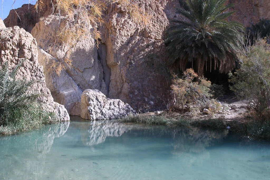
Todra Gorge, Morocco

In Southern Morocco, about six hours east of Marrakesh, lies the Todra Gorge, one of the world’s most beautiful canyons and a stunning climbing spot for climbers of all levels. Made by the River Todra carving its way through the limestone for thousands of years, the Todra Gorge is a canyon with cliffs rising over 400 meters high on either side. Todra Gorge boasts more than four hundred climbing routes, ranging from beginner to advanced. The first climbing routes in Todra Gorge were set by Spanish and French climbers in the 1970s, and new routes are constantly being developed by climbers who visit the gorge. One of the things which draws climbers to Todra Gorge is that it can be climbed year-round, as the weather and location ensures that there will always be a cliff in the sun during the winter or the shade during the summer. 

Other challenging climbs in Africa are the Milner Amphitheater and Table Mountain in South Africa, and Mount Kenya in Kenya. 

Asia

Railay Beach, Thailand 

Located in the Krabi Province of southern Thailand, Railay is a picturesque peninsula that juts off from the mainland. Although Railay is connected to the rest of Thailand, a series of steep cliffs separates the area from the rest of Thailand, meaning that no roads are able to come through to the peninsula and it is only accessible by boat. Railay has three beaches, all of which are lined by imposing limestone cliffs which make the area popular for rock climbing. Railay offers both sport climbing and bouldering, a form of free climbing. The most popular beach for climbing is Railay West, on the western side of the peninsula, but there are numerous routes on the other Railay beaches as well. Railay Beach boasts routes for climbers of varying levels, as well as some incredible views of the Gulf of Thailand. Two of the most-climbed areas of Railay Beach are the 123 wall and the Thaiwand Wall. Because of its location on the water, the beach provides another unique climbing experience: deep-water soloing. Deep-water soloing combines the free solo climbing style (no ropes or equipment) with water; without equipment, climbers make their way up craggy cliffs over deep bodies of water so if they fall, they land safely in the water. 

There are numerous other rock climbing destinations in Asia, including Long Dong in Taiwan, Cat Ba Island in Vietnam, Yangshuo in China and Mount Katsu in Japan. 


Rachel Lynch

Rachel is a student at Sarah Lawrence College in Bronxville, NY currently taking a semester off. She plans to study Writing and Child Development. Rachel loves to travel and is inspired by the places she’s been and everywhere she wants to go. She hopes to educate people on social justice issues and the history and culture of travel destinations through her writing.

Volcano Boarding in Nicaragua

Looking for an adrenaline rush? Slide down the side of an active volcano at up to 60 miles per hour during your stay in Nicaragua.

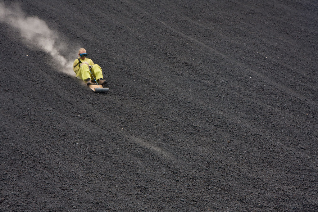
Volcano boarding on Cerro Negro, Nicaragua. Garrett Ziegler. CC BY-NC-ND 2.0.

Bigfoot Hostel in Leon, Nicaragua is one of the only places in the world where you can go volcano boarding. According to their website, volcano boarding is the “thrill of a lifetime.” The hostel’s original owner, Daryn Webb, created the extreme sport, where those brave enough to try it can speed up to 60 miles per hour down the side of an active volcano.

Webb and his crew tested various objects for sliding down the volcano, and after some trial and error, they created a sit-down toboggan made of metal and plywood. The hostel offers daily tours beginning at 9 a.m., with prices at $25 per person. Tours return at 3 p.m.

The Cerro Negro volcano is the youngest volcano in Central America, and is also one of the most active volcanoes in Nicaragua, erupting nearly every 20 years.

Bigfoot Hostel has sent over 20,000 people down Cerro Negro slope at up to  62 miles per hour, and it is known for attracting many sports enthusiats  and adrenaline junkies. One of the most famous people to attempt the extreme sport was Eric Barone, who rode down the volcano on a bike at 107 miles per hour in 2002.

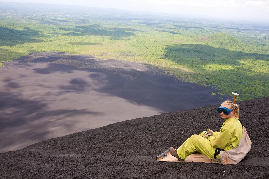
Volcano boarding on Cerro Negro. Garrett Ziegler. CC BY-NC-ND 2.0.

It is possible to slide down the Cerro Negro because the volcano is made of small grain-like volcanic rocks, which came from the crater. In addition, there is almost always a very strong wind hitting the volcano, so it’s the perfect surface for boarding.

Those who have visited before say that they could feel the heat radiating from the volcano and could even cook their meals in a hole dug out in the volcano.

All visitors must wear closed toe shoes and comfortable clothing. Those who have boarded down the volcano before recommend wearing hiking boots (since it takes about 45 minutes to reach the summit) and a multipurpose head wrap to cover your nose and mouth while boarding. Also, take a large water bottle and a GoPro if you want to record the experience.

The hostel offers dorm-style rooms, with rooms with fans at $6 and rooms with air conditioning at $10. There are also private rooms with double, triple, or quadruple beds.


Isabelle Durso

Isabelle is an undergraduate student at Boston University currently on campus in Boston. She is double majoring in Journalism and Film & Television, and she is interested in being a travel writer and writing human-interest stories around the world. Isabelle loves to explore and experience new cultures, and she hopes to share other people's stories through her writing. In the future, she intends to keep writing journalistic articles as well as creative screenplays.