An Explorer’s Guide to Visiting Edinburgh

From hiking up a volcano to ancient stone castles, a travel writer discovers the natural beauty and rich history of the Scottish capital

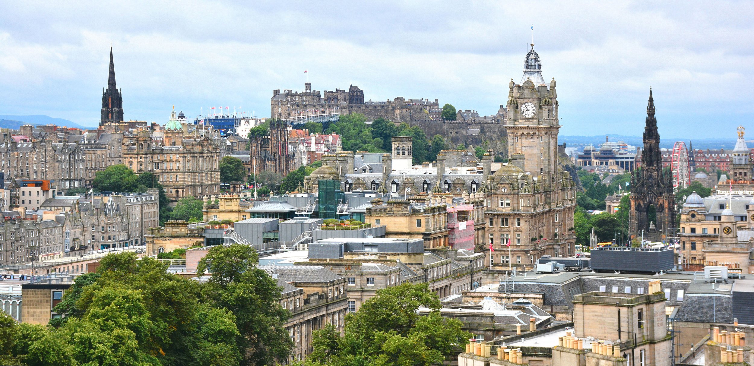
A view of Edinburgh’s skyline from Calton Hill. Mike McBey. CC BY 2.0.

Named TimeOut magazine’s best city in the world in 2022, Edinburgh is the perfect destination for those looking to experience the natural beauty and history of Scotland. Before visiting for myself, I knew very little about the city past its prestigious university, but I soon discovered how much more the city has to offer than the Loch Ness tours and Fringe Festival performances that initially came to mind. Edinburgh is located on the southeast coast of Scotland, just a 10 minute drive away from the North Sea. An ancient volcano which last erupted around 340 million years ago is responsible for the many volcanic rock formations surrounding the capital, one of which is now home to the city’s Old Town district.

Victoria Street is said to have been the inspiration for Diagon Alley in J.K. Rowling’s Harry Potter book series. Ralf Steinberger. CC BY 2.0.

Bird’s eye view shots of Edinburgh are often marked by a scattering of towering gothic constructions, but exploring the labyrinth of the Old Town was at the top of my list. In order to protect and preserve its impressive display of traditional British reformation-era buildings and rambling cobblestone streets, Edinburgh’s Old Town became a UNESCO World Heritage site in 1995. It stands in contrast to the city’s New Town in the north, which was constructed entirely in the Georgian style between the 1760s and the 1830s. The Old Town’s beautiful spread of architecture houses museums, galleries, ancient churches and shops, with Victoria Street being a favorite of mine because of its historic stone arches and colorful storefronts.

Exploring the area by foot is a must — I discovered countless hidden alleyways tucked between shops that led to smaller churches and hidden cloisters that were built hundreds of years ago. Spreading throughout the district, countless pubs make it a favorite among those looking to get a taste of Scotland’s national drink: whisky. Those under the age of 18, however, can happily enjoy the unofficial national drink of Irn Bru, a non-alcoholic soft drink first brewed according to a secret recipe back in 1901.

Edinburgh Castle sits at the very top of Castle Hill and looks out over the city from the West. Kim Traynor. CC BY-SA 2.0.

Perched on a volcanic rock outcrop sits Edinburgh Castle, with its ancient stone towers and turrets looking down over the Old Town. Fortunately, I booked tickets ahead of time and got to pass the huge crowds at the entrance, and visiting around midday when most people are stopping for lunch also allowed for a much more private exploration of the castle grounds. Depending on the part in question, sections of the castle date back to the 12th century, with newer additions being constructed by various monarchs over the next few centuries. I was able to get up close and personal with the Scottish Crown Jewels, and witnessed the daily firing of a cannon at 1 pm before touring the National War Museum, all set against the backdrop of Edinburgh’s eclectic skyline and the shoreline in the distance.

Holyrood Palace sits at the end of the Royal Mile and is the official Scottish residence of the British Monarch. Adam Fagen. CC BY-NC-SA 2.0.

Edinburgh’s other royal residence sits at the base of the ancient volcano responsible for the city’s unique geography. Still in use by the royal family today, Holyrood Palace was originally built by King James IV in 1503 upon his marriage into the British Monarchy. Very little remains of the original buildings as subsequent royals amended and added to the palace during their reigns. While generally open to the public year round barring royal visits to the Scottish capital, I chose to enjoy the palace’s facade from its visitor’s cafe, where a beautiful view of the Scottish Parliament building across the road can be seen. A short walk to the palace’s rear brought me to the entrance to a large park, which used to be part of the palace grounds but is now available for public use as well.

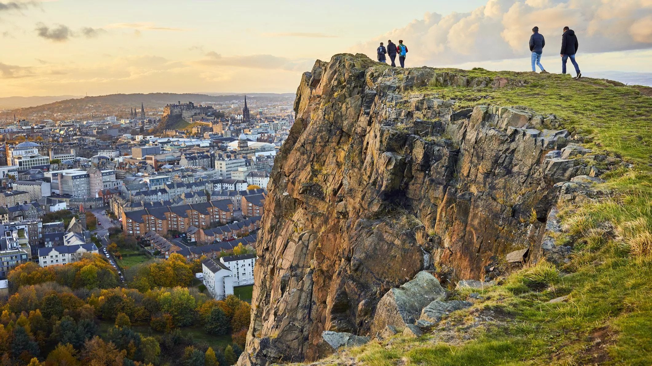
A view of Edinburgh from the top of Arthur’s Seat. Euan Marley. CC BY-NC-ND 2.0.

Surrounding the palace is Holyrood Park, home to the rocky spires of the Salisbury Crags and Arthur’s Seat, the remains of a now-dormant volcano. I made sure to familiarize myself with the various hiking trails to the volcano’s summit as signage within the actual park was very limited. Some of these routes were specifically for those looking to visit with their bikes, while others allowed for a much more leisurely stroll through the park’s meadows. The park also has a rich history: en route to the top of the 251 meter tall (roughly 823 feet) mountain lies the ruins of a medieval chapel and agricultural terraces from the Bronze Age. I came upon these sites by accident as they are not located along the main routes but are still easily accessible. Reaching the summit took just over half an hour, and the incredible 360 degree views of Edinburgh, and the surrounding towns were well worth the climb. A word of warning: despite visiting on a relatively warm and sunny day in the middle of the summer, the winds at the summit were still incredibly strong and should not be underestimated!

The National Monument is located at the top of Calton Hill. Culture Map. CC BY-NC 2.0.

For those looking for picturesque views of Edinburgh’s skyline without an hour long hike, Calton Hill is a perfect alternative. Also known as “Edinburgh’s Acropolis”, the 10 minute walk along a paved road to the top was significantly easier than the climb up Arthur’s Seat. Once at the top, I discovered the Collective Gallery, a contemporary art center that cycles through exhibits by local Scottish artists, as well as a luxury boutique restaurant with stunning views of the city. Also on the hill are the National and Nelson Monuments, the former being dedicated to Scottish soldiers who perished in the Napoleonic Wars. The monument was intended to be an exact replica of the Parthenon down to the exact dimensions of each block of stone. Unfortunately, the monument was only half finished when work stopped in 1829 and was never completed, though the part that stands today still forms an impressive and iconic part of Edinburgh’s skyline.

Nelson’s Monument stands in front of the Edinburgh skyline as seen from the top of Calton Hill. Andrew Colin. CC BY 2.0.

More than anything, I was surprised by how well Edinburgh was able to marry its incredible history with modern luxuries and infrastructure. It is a city of contrasts tucked in between rocky volcanic hills and the vast North sea, with Michelin-starred restaurants housed in old Georgian townhouses, and traditional tartan sold alongside extravagant cashmere. You can just as easily enjoy a plate of traditional haggis in an ultra-modern gastropub as you can take in a Shakespeare play in the newly renovated King’s Theater Dome. My visit, while only 3 days long, was jam packed with experiences unique to Edinburgh’s distinctive geography, history and culture. There is truly something to interest everyone and more, if you are willing to go off the beaten track and venture down an intriguing cobblestone alleyway or two.


Tanaya Vohra

Tanaya is an undergraduate student pursuing a major in Public Health at the University of Chicago. She's lived in Asia, Europe and North America and wants to share her love of travel and exploring new cultures through her writing.

Jeju: South Korea’s Largest Island

Jeju-do, known as Jeju Island, is the largest island in South Korea, and is home to beautiful natural scenery and an interesting community of women divers known as haenyeo.

Jeju Island. Republic of Korea. CC BY-SA 2.0

South of the Republic of Korea lies Jeju Island, a volcanic island famous for its beautiful beaches, resorts and landscape. The volcano on the island is a shield volcano called Hallasan, and it is the largest mountain in South Korea, standing at 1950 meters tall. Its status is considered active, but there are some who disagree since the last time it erupted was in 1007 AD. Also, the volcano does not smoke, and there is no fire coming out, so it appears to be dormant, hence the disagreement. Jeju Island is both the largest and only island in South Korea that governs itself. It is home to the World Heritage Site Jeju Volcano Island and Lava Tubes, and it is one of the new 7 wonders of nature alongside areas like South America’s Amazon Rainforest, Indonesia’s Komodo Island, South Africa’s Table Mountain and others.

Beyond the volcano, the island also has a network of lava caves and tunnels. The beaches, too, are beautiful, and there are walking trails called Olle, which means “a winding path to your front door” in the local dialect. They cover almost the entire island, and along their route people can see the sea, rock formations, caves and more. There are interesting rock sculptures known as Dol Hareubang, which are statues carved from the volcanic rock all over the island. The name translates to “grandfather made of stone”, and they get this name because they all have elderly features. They are also considered to be guardians of the island that ward off evil spirits and demons.

Dol Hareubang. Charity Davenport. CC0 1.0

Beyond the natural beauty of the island and the stone statues, Jeju Island is home to a community of women, known as Haenyeo. They are all divers that gather food from the sea like oysters, sea urchins and abalone. The thing that makes them truly unique, however, is the fact that they don’t use oxygen masks. They free dive down to as deep as 30 feet below the surface and can hold their breath for minutes. Girls start learning how to swim, dive and help the women from as young as 8 years old, and there are women still diving who are in their 80s. The women have been the ones to do this for many years, in part because there were a lot more of them than men on the island. The Korean War also caused an increase in women being more economically engaged. 

Haenyeo are considered to be the first working mothers of South Korea and have made diving their profession. There are no men participating in the dives and harvesting of seafood. Like many places, South Korean society has been typically male dominated, so the women on Jeju Island are very different. They have been diving for the past 1700 years, but after an increase in the demand for seafood the haenyeo were doing well and they started  trying to provide better education and other career options. As a result, many women choose  to not follow the diver tradition and the number of haenyeo has decreased since then. A lot of them are also older women who have been doing it for their entire lives, while the younger and middle-aged women chose to follow career paths. The women’s work and contributions have led to them being mentioned in UNESCO’s list of Korea’s cultural heritage in 2016.


Katherine Lim

Katherine is an undergraduate student at Vassar College studying English literature and Italian. She loves both reading and writing, and she hopes to pursue both in the future. With a passion for travel and nature, she wants to experience more of the world and everything it has to offer.

Will Bougainville Become the World’s Newest Country?

98% of the Bougainville population voted for independence from Papua New Guinea in 2019, but the quest for nationhood remains uncertain.

A view of Bougainville. Jeremy Weate. CC BY 2.0.

In 2019, Bougainville, an island that is politically part of Papua New Guinea (PNG) but culturally and linguistically separate, voted overwhelmingly for independence. Around 98% of the population voted to leave PNG to form their own country. With such a large majority supporting independence, the government of PNG cannot ignore the demands of Bougainville, and negotiations  are currently underway to devise a peaceful path to independence that satisfies both parties involved.

Located around 160 kilometers from the island of New Ireland and 1,000 kilometers from Port Moresby, the capital of PNG on the island of New Guinea, Bougainville is geographically part of the Solomon island chain. Due to its remote location from the rest of PNG, it has a unique history. A part of the German Empire until 1946, PNG was then transferred to Australian administration. When Australia granted independence to PNG in 1975, Bougainville was to be included in the new country, against the protests of the people there.

The people of Bougainville made several attempts at independence over the years, including in 1975. In the late 1980s, the region got plunged into a civil war due to the disagreements over the operation of the Panguna mine, one of the largest and most profitable mines in the world. To the residents of Bougainville, the mine, which was supported by the PNG government, represented another imperial imposition to their land. As part of the peace settlement that established Bougainville as an autonomous region in 2001, the residents of Bougainville were to be entitled to an independence referendum every 10 to 15 years. That first referendum happened in 2019, which resulted in overwhelming support for independence.

The location of Bougainville relative to the rest of PNG. Mr Accountable. CC BY-SA 3.0.

The next steps are uncertain. It is not feasible for any entity to gain complete independence overnight so there will be a transition period before Bougainville becomes a fully sovereign country. The agreement between Bougainville and the rest of PNG stipulates that independence shall be attained no later than 2027. Both parties are now trying to figure out the best way forward.

PNG is generally reluctant to grant independence to Bougainville, as their prime minister James Marape is worried that giving independence to Bougainville will set a precedent for other secessionist parts of the country. He insists that the parliament of PNG must approve independence. The government of PNG also points out that the referendum is non-binding.

The Bougainville side, however, says that the role of the parliament is only to ratify the actual results of the referendum or the outcome of the post-ratification consultations. After over a year of negotiations, both parties, in 2021, agreed to have a political settlement “no earlier than 2025 and no later than 2027.” Most governmental powers will also be transferred to Bougainville by 2023, with the rest to follow by 2027.

However, challenges remain. Today, Bougainville has a GDP per capita of $1,100, which is around the same level as the Democratic Republic of the Congo, Niger and Somalia, all of whom face notable challenges in poverty, health and political stability. It remains to be seen whether Bougainville will be able to secure recognition by other nations, as well as become a member of the United Nations, usually considered one of the benchmarks of independence. Ensuring a peaceful transition that results in a stable government that does not depend on foreign aid will be essential in the future success of Bougainville. While not there yet, the world could welcome a new country by 2027.


Bryan Fok

Bryan is currently a History and Global Affairs major at the University of Notre Dame. He aims to apply the notion of Integral Human Development as a framework for analyzing global issues. He enjoys hiking and visiting national parks.

The Long Road Home: Should Western Museums Repatriate Artifacts?

Should the thousands of artifacts looted from their countries of origin during colonial times be returned home?

Almost 900 of the Benin Bronzes, a collection of ancient Nigerian artifacts widely considered stolen, are now on display at the British Museum. Lauren Fleishman. CC BY-SA 2.0.

While archaeologists must abide by a number of strict ethical guidelines when conducting research in foreign countries, museums are seldom held to the same level of scrutiny when acquiring artifacts. Many world class museums house relics of significant historical and cultural importance, undoubtedly attracting both hordes of curious visitors and a great deal of commercial benefit. The question is, however, should these museums really be benefitting from objects that they have effectively stolen from other countries? The question of repatriating many of these looted artifacts has been the center of great controversy in recent years, as many ex-colonial countries who are victims of such theft are beginning to contest the legal ownership of these objects.

The Elgin Marbles are original parts of the Parthenon and were taken from Athens in the early 1800s to the British Museum. Wally Gobetz. CC BY-NC-ND 2.0.

On the prolific collection of artifacts on display at the British Museum in London, which currently have contested ownership, Professor Chika Okeke-Agulu, a renowned art historian and professor of Nigerian heritage now teaching at Princeton University commented, “You cannot claim to be an encyclopedic collector of stolen objects.” His view makes reference to the historically familiar colonial behavior that many have begun to recognize in the attitudes of the British Museum and many other similar Western institutions towards the repatriation of artifacts. Giving back the artifacts, however, may not be as simple as flying them back home. In the specific case of the British Museum and other museums in England, the British Museum Act of 1963 legally limits any desire to return the Benin Bronzes from Nigeria, the Amarvati Marbles from India and even the world famous Rosetta Stone originally from Egypt among thousands of other objects.

King Philippe of Belgium (right) returning a historical Kakuungu mask to Congolese President Félix Tshisekedi (left) during a state month in June, 2022. Cabinet of Prime Minister Alexander De Croo. CC BY-NC-ND 2.0.

There have been a few stories in recent news highlighting the successful repatriation of artifacts to the ex-colonies they were taken from. June of this year marked the beginning of Belgium’s pledge to return more than 80,000 artifacts looted from the Democratic Republic of the Congo (DRC) over the 75-year period during which they ruled over the colony. King Philippe of Belgium expressed his “deepest regrets” over his country’s treatment of the DRC in a letter to the Congolese president Félix Tshisekedi back in 2020, the 60th anniversary of the country’s independence. The King handed a “Kakuungu” mask handmade by the Suku people native to the southwest region of the DRC to President Tshisekedi during his state visit to Kinshasa last month. This particular artifact had been housed in the Royal Museum for Central Africa located near the Belgian capital of Brussels, a site used as a “human zoo” towards the end of the 19th century, where hundreds of captured Congolese villagers were put on display in abysmal conditions.

Turkey’s Culture Ministry claims that tiles in the Ottoman Wall display at the Louvre Museum’s in Paris were stolen from Turkey in the 19th century. Ömer Erbil. CC BY-NC 2.0. 

To the many in favor of artifact repatriation, getting the objects home is more than just about the claims of ownerships over these pieces. Many, if not all, of these artifacts is incredibly significant to the cultural and historical identities of countries that suffered under colonial rule, and this inability to access vital parts of their own histories are simply a continuation of that hardship. The popular claim among Western museums that they are simply housing the objects so that they remain accessible to all is also a contentious one. In an interview with CBC, Professor Okeke-Agulu called the argument “stupid” due to its implicit understanding that the museums are only thinking about access to visitors from other Western countries, rather than those from the African continent for whom it is extremely difficult to travel across the world to enjoy these artifacts. He and many others believe that the return of these objects is long overdue -- that these institutions need to get “on the right side of history”.


Tanaya Vohra

Tanaya is an undergraduate student pursuing a major in Public Health at the University of Chicago. She's lived in Asia, Europe and North America and wants to share her love of travel and exploring new cultures through her writing.

Macaque Monkeys Attack in Yamaguchi, Japan

Macaque monkeys, previously peaceful residents of Yamaguchi, Japan, began targeted attacks in July. 

Japanese macaque. Zweer de Bruin. CC BY-NC-ND 2.0. 

The city of Yamaguchi, Japan boasts historic temples, invaluable art, stunning gardens and macaque monkeys. Macaque monkeys have lived in highly populated areas of Japan since as early as the 1600’s, and up until recently, Japanese macaques have had very few concerning interactions with people.

However, since July 8th, more than fifty people in Yamaguchi have been attacked by the monkeys. City officials and experts say nothing like this has ever happened, and they even initially thought it was only one crazed monkey committing all of the attacks. But even after the monkey in question was euthanized, the attacks continued, leading the city to realize that an entire band of monkeys had inexplicably started attacking humans after years of peaceful  coexisting. Fortunately, as of late July, no serious injuries have occured, but city officials have taken to tranquilizing threatening macaques, as they are not deterred by food or traps. 

What makes these unprecedented attacks even more puzzling is the fact that they seem very coordinated, with an explicit goal, even if that goal is unclear to the people of Yamaguchi. While minor injuries have resulted from the attacks, some of the attacks appear to be attempted kidnappings. Additionally, the monkeys began by targeting primarily young children and older women. While over the past few weeks they have begun attacking adult men as well, these demographics are so specific that it begs the question: what is their intent? Unfortunately, no one knows yet. 

A mother in Yamaguchi recalls a monkey having broken into her home, and attempting to drag her child away. She noted that the monkey tried to take the child with it. The monkeys have been entering homes, and even lurking outside of nursery schools. While there have been occasional macaque attacks in the past, they primarily live in harmony with humans, and a planned effort like this is unprecedented. 

Two Japanese macaques. Etsuko Naka. CC BY 2.0. 

In terms of the history of Japanese macaques, as noted they have lived in Japan since as early as the 17th century. They are also incredibly intelligent animals, making the decision of the Yamaguchi officials to euthanize one a difficult call. Macaques have opposable thumbs and even sometimes walk on two legs. They are known for doing very human-like activities, such as bathing and relaxing in groups in hot springs in Japan. This habit, as well as the habit of washing their food in the ocean, was learned behaviors within the group, and previously, scientists thought only humans passed traditions and behaviors through generations. 

Despite the monkey attacks, which will hopefully come to an end soon, Yamaguchi has many sites to visit and a fascinating history. It is known for its temples, such as the Rurikoji Temple and Joeiji Temple. It is also a coastal town known for having high quality seafood and sake, which is perfect for travelers interested in food. Additionally, Yamaguchi is a very historic area, as the city contributed to the overthrow of the feudal era in Japan in the late 1800’s

Tokoji Temple in Yamaguchi, Japan. Yoshitaka Ando. CC BY-NC-ND 2.0. 

Ultimately, Yamaguchi, Japan is a beautiful and historic city which is currently experiencing turmoil at the hands of macaque monkeys. Officials hope that the situation will be resolved soon, and once it is, consider adding Yamaguchi to your travel list.


Calliana Leff

Calliana is currently an undergraduate student at Boston University majoring in English and minoring in psychology. She is passionate about sustainability and traveling in an ethical and respectful way. She hopes to continue her writing career and see more of the world after she graduates. 

7 Breathtaking Waterfalls Around The World

From the tropical jungles of the Philippines to the glacial mountains of Iceland, these seven waterfalls are some of the most beautiful out there.

The Cascadas de Agua Azul, located in southern Mexico, are a series of waterfalls on the Xanil River. Claudia Tavani. CC BY-NC 2.0.

Every year, countless travelers visit the world’s tallest waterfalls, with Niagara Falls receiving over 13 million visitors alone. However, it is only one of hundreds of waterfalls in North America, and one of thousands worldwide. Hidden away in corners of South America, Europe, Africa and Asia are a multitude of other falls that display nature’s power and beauty. Waterfalls are divided into ten categories depending on their geographic surroundings and how they descend through them.  These include punchbowl waterfalls like the Kawasan Falls at number three on our list, horsetail waterfalls, chutes, cataracts, cascades like the one found at Akchour at number seven on our list and block waterfalls formed by wide rivers falling in uninterrupted sheets, to name a few. Here are seven incredible highlights that may not be the tallest or widest in the world, but are absolutely unmissable simply for their sheer beauty.

1. Plitvice Waterfalls, Croatia

Croatia’s Plitvicka Jezera National Park is home to a beautiful network of lakes and waterfalls. Jack Brauer. CC BY-SA 2.0.

Located in central Croatia between the country’s capital of Zagreb and the coastal city of Zadar, Plitvice Lakes National Park has been a UNESCO World Heritage site since 1979. Its protected area spans 300 square kilometers (roughly 115 square miles) and comprises a network of lakes and caves, which are connected by a series of breathtaking waterfalls. These can be viewed from the various footpaths and wooden bridges that traverse the park, or visitors can also enjoy a boat ride included in the price of the entrance ticket. Because of its protected status, the park is also home to bears, wolves and eagles among a whole host of wild animals.

2. Iguazu Falls, Argentinian-Brazilian Border

A birds eye view of one of the many waterfalls in Iguazu National Park, Argentina. Tomfriedel. CC BY 2.0.

The Iguazu Falls stretch for 2.7 kilometers (around 1.7 miles) along the border between the Misiones province in Western Argentina and the state of Paraná in Eastern Brazil. Altogether, the network makes up the largest system of waterfalls in the world, and was accordingly named a UNESCO World Heritage site in 1984. Thanks to a longstanding preservation effort in the two national parks on either side of the border that share custody of the falls, a network of walkways and viewing platforms can bring visitors very close to the falls, including near the bottom in an area called “Devil’s Throat”. You can travel to the falls by car from both the Brazilian and Argentinian sides, as well as from the Ciudad del Este in Paraguay. 

3. Kawasan Falls, Cebu Island, Philippines

Kawasan Falls is hidden away in the jungles of Cebu Island, Philippines. Vicky Flip Flop. CC BY-NC-ND 2.0.

The Instagram famous turquoise waters of Kawasan Falls are reachable by a three-hour bus ride southwest of Cebu City in the Philippines. The tropical waterfall is accompanied by limestone canyons and a dense jungle, all of which surround the pools often referred to as the “Gatorade Factory” due to their incredible color. Located in the coastal municipality of Badian, visitors can hike the kilometer and a half (just under a mile) long route uphill to reach the first and largest of many waterfalls that make up the series. Those interested in spending more time in the area can even book cottages available for overnight stays, though most opt to simply rent bamboo rafts to explore the pools.

 4. Gullfoss, Iceland

Iceland is home to numerous waterfalls with the Gullfoss Waterfall being a favorite among locals. O Palsson. CC BY 2.0.

The Icelandic name Gullfoss translates into “golden falls” in English, a reference to the sediment in the Hvita River from the nearby glacier that causes this spectacular waterfall to glow gold in the Nordic sunlight. Located a 90-minute drive west of the capital of Reykjavik, the two cascades that form Gullfoss are not actually that tall, falling for a total of only 31 meters (roughly 102 feet). However, seeing the waterfall up close can still be a deafening experience with floods of water going over the edge at a rate of around 109 cubic meters (just under 50,000 cubic feet) per second. There aren’t any railings or barriers either, so it is up to visitors to keep a safe distance from the cliff’s edge.

5. Weeping Wall, Hawai’i, USA

Travelers can visit Hawai’i’s Weeping Wall located in the heart of Kauai Island. Ahonui Bowman. CC BY-NC-ND 2.0.

Hawai’i is well-known for its incredible natural beauty, and the Weeping Wall is one of many spectacular sites on the island of Kauai. The network consists of a series of extremely narrow waterfalls winding across the centrally located Mount Waialeale, which stands 1,569 meters (about 5,066 feet) tall. The mountain’s name translates from Hawaiian to “overflowing water”, given that this location is in fact the second wettest area on the planet, and receives just under 11.5 meters (just under 37.5 feet) of rain every year. Given the mountain’s height, visitors rarely get a view of the upper part of the falls as it is often hidden in the clouds, but watching the water tumble down through the tropical greenery is still an incredible sight to see.

6. Ban Gioc Waterfall, Vietnam

A view of the Ban Gioc Waterfalls from Cao Bang, Vietnam. Applejuice. CC BY-SA 2.0.

Located on the border between the Cao Bang province in Northern Vietnam and the Guang Xi province in Western China, the Ban Gioc falls are the largest waterfall network in Asia. The waterfall stretches over 30 (about 98 feet) across on the Chinese side where it is known to locals as the De Tian Waterfall instead. Ban Gioc cascades down over three tiers of lush greenery, feeding directly into the Quay Son River, which in fact runs along the China-Vietnam border. Traveling to the falls from the Vietnamese capital of Hanoi normally takes visitors about two days to complete, with an overnight stop in Cao Bang City to split up the six and a half hour drive. 

7. Cascades D’akchour, Morocco

The higher of the two waterfalls that make up Cascades D’akchour near Chefchaouen, Morocco. Culture Trekking. CC BY-ND 2.0.

The Cascades D’akchour are tucked in amongst the Rif Mountains, the northernmost chain in Morocco. Reachable via a 45-minute drive from the famed “blue city” of Chefchaouen, visitors can enjoy a mountainous trek connecting several smaller waterfalls before arriving at the final cascade whose upper section tumbles down 100 meters of rock face (roughly 328 feet) into a collecting pool. The lower cascade, on the other hand, stands at a much smaller 20 meters tall (just under 66 feet) but also features a natural swimming pool just upstream of its descent over the cliff. For those interested in exploring even further, another hour and a half of hiking can bring you to the Pont de Dieu or Bridge of God, a naturally formed rock bridge carved out of the mountain by the Farda River.


Tanaya Vohra

Tanaya is an undergraduate student pursuing a major in Public Health at the University of Chicago. She's lived in Asia, Europe and North America and wants to share her love of travel and exploring new cultures through her writing.

Reduce Your Carbon Footprint by Home Composting

Self made compost can take time to make, but it can easily lower someone’s carbon footprint.

Compost Pile. Lindsay. CC BY 2.0

Food waste is a major component of global warming, with all the methane that food produces in landfills when it rots. However, even if someone can’t finish all their food and have a little bit left, they can still lessen their food waste and overall carbon footprint in various ways like home composting. Since around ⅓ of the food produced in the entire world is wasted, composting organic waste can reduce roughly half of greenhouse gasses equivalent to carbon dioxide between 2020 to 2050. Composting is a process of turning organic waste into soil or mulch, and the compost that comes from it is nutrient rich and good for plants, so by composting, people can reduce their food waste and help plants grow. 

For composting at home, there are multiple things to keep in mind before starting. The first is that composting is going to take a lot of time, with anywhere between six weeks to an entire year depending on the method, and how much effort is being put into making the compost. The second is that there are two types of items to compost, “green” and “brown” items. Green means the food scraps, grass clippings, coffee grounds and tea leaves that are full of nitrogen, while brown ones are the carbon-rich items, like cardboard, egg cartons, dried leaves and wood shavings. Since the green items tend to be “wetter”’ and the brown ones more “dries”, an equal mix is good, though some say it is better to have a 1:3 green to brown ratio. As long as the pieces in the mix aren’t extremely large, and there is good moisture and access to air and oxygen, the pile will decompose into compost. Turning the mix every few days will help bring in more oxygen to help the process and control the odor. The oxygen is especially important because without it, the food will still compost but in an anaerobic way, which will produce a gas that is half methane and half carbon dioxide. Methane traps radiation much better than carbon dioxide, so it contributes to global warming 25 times more per pound.

Fruit on Compost Pile. Allispossible. CC BY 2.0

There are multiple methods of composting at home, but the fastest way is to simply get a home composting bin. There are many composting bins available for sale, but it is also possible to make a homemade one. With a compost bin, all that is required is to place the waste inside and let it decompose at a faster rate than leaving it outside. Some bins will continuously compost materials, while others will make batches of it.

Though using a bin is the easiest method, it is possible to do home composting without one. It is a little slower since the heat isn’t contained, but it works just as well. Trench composting is a technique that involves digging a hole roughly a foot wide and deep, then filling it halfway with kitchen scraps and other organic food waste inside before covering it up. Creating a heap and layering the materials in it also works, though it is better with some space as it may attract flies as the food rots. But, it has access to air, and needs access to water, and within a few months, the compost pile will be ready. To speed up the process, it is possible to use worms or other accelerators. 

Composting is a popular method around the world, especially among European countries. Germany has a high recycling and composting rate, sustainably getting rid of 65% of their waste as of 2019. Austria, Slovenia, Belgium and Taiwan also have recycling and composting rates higher than 50%. South Korea, however, recycles around 95% of its food waste by turning it into compost, animal feed, or biofuel. Their laws against sending food waste to landfills and having biodegradable food scrap bags that could be composted and compost bins for people to use have greatly added to this, as well as some places that track food waste per household and charge them for it. 

To Get Involved

Many communities have composting programs that aim to advertise the benefits of composting and will help people do it. Even in large cities where people live in apartments and don’t have a backyard to compost in, there are organizations that will take in food waste and compost it for people. In New York City, the Department of Sanitation (DSNY) has multiple programs just like this, focused on composting, educating, and waste management. CompostNow is an organization that has community gardens and programs in multiple locations that will take in food waste to be composted. Ecoscraps is another company that collects food waste, recycles it, and then sells the resulting compost. Their compost is available all over the country in stores like Home Depot and Walmart.

To find out more about the DSNY, click here.

To find out more about CompostNow, click here.

To find out more about Ecoscraps, click here.


Katherine Lim

Katherine Lim is an undergraduate student at Vassar College studying English literature and Italian. She loves both reading and writing, and she hopes to pursue both in the future. With a passion for travel and nature, she wants to experience more of the world and everything it has to offer.

Soldiers Speak: War Crimes in Myanmar

Recent atrocities and war crimes have been reported by military soldiers in Myanmar as the civil war rages on. 

Human rights protest for Burma in France. Totaloutnow. BY-NC-ND 2.0.

Myanmar has a dirty, bloody history attached to the political and military conflicts that have furiously swept through their country. The civil war that rages on adds to this history, and the war crimes and atrocities that are currently occuring illuminate the fragility and deep rooted struggles between the Burmese government and its citizens.

The civil war started in February of 2021 after Myanmar’s military powers – known as the Tatmadwa – seized the government from the elected officials of the National League for Democracy (NDL), the leading civilian party in Myanmar. The NDL had won the election in 2021 by 83%, the New York Times reports, but the military ignored these results, an action said to be linked to the government's dislike for Aung San Suu Kyi. She was the leader of the NDL who would have become the elected official of the Burmese government. 

The military coup that overthrew the government in 2021 was the event that turned the tide of the political state of the country, and now battles between military soldiers in the Tatmadaw and pro-democracy armed civil militias have erupted and raged now for almost two years. 

The military powers in charge currently – referred to as the junta: a “group of military leaders” as BBC explains – are led by General Ming Aung Hlaing. He was given power from military leaders after the coup in 2021. General Ming is responsible for the imprisonment of countless NDL members, as well as multiple ‘campaigns against ethnic minority groups’ including the Rohingya Muslim Genocide that has been taking place in Myanmar for years.

Rohingya refugees. Austcare-World Humanitarian Aid. CC BY-NC-ND 2.0.

As the war continues to rage on, Tatmadaw soldiers have started to come forward with stories of the atrocious war crimes that they were ordered to commit onto the civilians of Myanmar. BBC has reported that soldiers have admitted to “killing, torturing and raping civilians”. Large scale human rights violations have continued to occur as well, including the imprisonment of protesters, the treatment and killing of political prisoners and the treatment of civilians during wartime conflicts has sparked dialogue from the United Nations (UN). The UN reports that military powers have “directly targeted civilians” with airstrikes and attacks, and have already killed “at least 1,600 people”.

Six anonymous soldiers agreed to an interview with BBC, where they told the story of crimes against humanity, one of the few crimes that can be prosecuted at the Internationcal Criminal Court, being committed at the hands of the unstable Tatmadaw military regime. One reported that they had been told to “shoot anything they saw; another was ordered to burn down a house with civilians locked inside it. Other soldiers admitted to witnessing women being raped at gun point after soldiers believed the victims to be supporters of the People’s Defence Force (PDF) – an armed civilian militia organization. These six soldiers also discussed the energy of other members of the regime, stating that some soldiers would ‘boast’ about their crimes and actions.

Villages have burned to the ground, civilians have been abused, killed and looted. This is the current fate of the Burmese people, but the civilian militias continue to fight back and continue to push for democracy. In a country so often torn between citizens and the military state, the fate of the people of Myanmar has remained undecided. The UN states in their report that “despite spiraling violence… ‘the will of the people has clearly not been broken.’” Determined to return to a time of democratic rule, the civilian population of Myanmar continues to fight against the horrors of the military regime wishing to dominate them.

TO GET INVOLVED

The Committee Representing Pyidaungsu Hluttaw is, as Insider states, “the country’s democratically elected legislature,” the very same that was overthrown in the coup in 2021. They have a GoFundMe, which is run by the Citizen of Burma Award Organization, that uses the money to support pro-democracy protests and encourages civil disobedience against the junta military regime. To donate to the protestors, click here .

The Civil Disobedience Movement also collects donations which are sent directly to people in Myanmar to fund and support civil disobedience and protests against the government. To donate, click here.

Additional ways to GET INVOLVED can be found in Insider’s “5 Ways to Help Anti-Coup Protests on the Ground in Myanmar Right Now”. This article discusses multiple ways to donate, to educate oneself and to create constructive and far reaching conversations about the injustices befalling the Burmese people. To read more, click here.


Ava Mamary

Ava is an undergraduate student at the University of Illinois, double majoring in English and Communications. At school, she Web Writes about music for a student-run radio station. She is also an avid backpacker, which is where her passion for travel and the outdoors comes from. She is very passionate about social justice issues, specifically those involving women’s rights, and is excited to write content about social action across the globe. 

All-Woman Rowing Team Takes On The Great Pacific Race

Four women compete in the Great Pacific Race, rowing from San Francisco to Hawaii.

For those who row competitively, completing the Great Pacific Race (GPR) is the pinnacle of a successful career. The race – which is a total of 2,080 miles (3,328 meters) – starts in San Francisco and ends in Hawaii. Teams of 3 or 4 are able to enter and are challenged to make it to Hawaii in as little time as possible. Though completely alone in their rowing efforts, every team is monitored from afar during all hours of the day by GPR crew in the instance of any emergencies.

Latitude 35, an all-female rowing team vetted with years of ocean rowing experience, has decided to challenge themselves in completing the Great Pacific Race. Among them are Adrienne Smith, Libby Castello, Sophia Denison-Johnson and Brooke Downes. They are not the first all-women’s team to compete, but they may be the fastest to ever finish the race if they maintain their pace on the last leg of their journey. The previous record that Latitude 35 wishes to crush is set by the Ocean Sheroes, who took on the challenge in 2021 and completed it in a little over 35 days. 

The first Great Pacific Race occured in 2014, and the organizers have held four subsequent “campaigns” since, with a total of 19 teams to ever complete the journey. Usually four or five teams will compete in the same race at a time, traveling from all over the globe to test their strength and willpower. Within the five sets of races that have taken place over the years, itvNews reports only “two four-person all female teams” have finished the race, making Latitude 35’s journey all the more special. 

Additionally, competitors are racing against the clock, not necessarily each other. To “win” the race, teams have to complete the journey the fastest, so the women of Latitude 35 are technically competing against teams – specifically the Ocean Sheroes – from a year ago who hold the current time record. Men and women may compete during the same campaign, but the race time records are separated by gender. However, it is important to note that just completing the challenge is a victory in itself; holding the world record for fastest time is just an additional win. 

Having left on June 21st, the Latitude 35 women have just about 495 miles (792 kilometers) left in their journey, and have done around 1590 miles (2,544 kilometers) in just over 28 days. They are on track to beat the pre-existing time record.

Besides the competitive nature of the race, it is also an incredible immersive experience with nature. Traveling on the open ocean for days allows participants to become up-close and personal with the ocean and all of its wonders. The Great Pacific Race describes the experience: “You will see shooting stars and the most incredible skies. You will experience nature in a way that few people can even imagine.” Latitude 35 has described their experiences with wildlife, including flying fish that have hopped around and into their boat.

The team has faced a few challenges along the way, including Tropical Estelle and Hurricane Darby, which threatened to hit the women’s route while they were on the open waters. Fortunately, neither the tropical storm nor the hurricane has found its way to the team, and the women are still safely continuing on.

The Great Pacific Race is a challenge of extraordinary athletic and physical strength. Calloused and blistered hands, sunburnt skin, hunger and fatigue all challenge the rowers. It is also a true test of emotional stamina and friendship. There is no reprieve from the rowing and physicality of the sport, just as there is no reprieve from your teammates. Latitude 35 has taken to Instagram to pass the time, and as they speak of their journey and the hardships they face – like rowing at night when all you want to do is sleep – they have gained a large following. 

Posting regular updates lets followers know where they are in their journey, as well as how they pass the time. Singing, laughing and making funny videos has helped the women stay motivated to finish their race. Additionally, Latitude 35 has started collecting donations for the Anxiety and Depression Association of America, raising money and awareness of the organization and what it has to offer athletes and those suffering with mental illness.


Ava Mamary

Ava is an undergraduate student at the University of Illinois, double majoring in English and Communications. At school, she Web Writes about music for a student-run radio station. She is also an avid backpacker, which is where her passion for travel and the outdoors comes from. She is very passionate about social justice issues, specifically those involving women’s rights, and is excited to write content about social action across the globe. 

Wealth Inequality in South Africa

Due to lingering remnants of apartheid, South Africa has the highest income gap in the world, with 10% of the population owning 80% of the country’s wealth.

Town in Soweto. Eugene Wei. CC BY-NC-SA 2.0

Though apartheid ended in 1994, many traces and effects of it still exist today, almost thirty years later. The World Bank demonstrates that South Africa has the highest rate of wealth inequality out of any country in the world. The spacial and racial segregation caused by colonialism and apartheid in the 1990s continue to affect South African society.

The United Nations University (UNU) wrote a policy brief in 2019 discussing the socio-economic inequality in the country, and mentioned that a majority of the wealth earned in South Africa goes to the top 5% of people. A recent article by Bscholarly covered the richest people in South Africa, and almost all of them were white men. Many were born in the country and are old enough to have lived through apartheid, benefitting from it in a way the non-white South Africans did not. So many people were living in abject poverty during that time period, and though it is over, many people are still suffering.

In the UNU’s policy brief, they mention how equalizing wages for workers, as well as gender and racial inequality needs to be progressed. Since so much of the economic gains go to the richest people in the country, most of whom are white, the poorer, non-white people are suffering. By increasing the income of low wage workers and therefore distributing the wealth to other people, the economic disparity would decrease. Even until 2019, the average white South African was making three times more than the average black South African, and Time magazine said, in 2021, that the wealth gap in the country has not changed since apartheid ended. The effects of the racial segregation go beyond just the wage gap, into the poor education system for black Africans and even the layout of towns, since the people were forced into parts of their towns that were away from where a lot of jobs are. 

Comparison of houses. UK Department for International Development. CC BY 2.0

In addition, the COVID-19 pandemic has only served to highlight the inequalities within the country. The job market’s difficulties, in particular, were highlighted during the pandemic as unemployment increased and low wage workers suffered, much more so than their high wage counterparts. Many of these low income workers are black Africans, which further shows the racial inequalities. Younger people were also disproportionately affected by the unemployment rates compared to higher age groups. The labor inactivity, high unemployment and lack of many self-employed workers are all key factors that are affecting the labor market, and, as a result, the overall economy of the country. If the government were to invest more and build up this area, the economy would improve and the wealth disparity would decrease, since people on the lower end of it would earn more money to improve their circumstances, as well as those of the people around them. Simply strengthening the labor market and especially investing in self-employment and entrepreneurship would help this problem, especially the entrepreneurship factor, since helping people with financing and learning new skills will lead to more self-employment which would lead to the growth of smaller businesses that can help poorer groups.

To get involved:

There are multiple organizations dedicated to social justice in South Africa. For example, Oxfam South Africa is an organization working to educate people on the wealth disparity and its impacts. They also aim to create an accountable government to help the people, and protect natural resources. The effects of COVID-19 have emboldened them as the problems were highlighted from responses to the virus. 

To learn more about Oxfam South Africa or to donate to them, click here.

Other organizations such as Siyabonga Africa and CHOSA are also focused on reducing the poverty and lack of education in South Africa. Siyabonga Africa provides necessary items for the impoverished, has created various skill courses for people to learn, and supports small businesses to help people get jobs. 

To learn more about Siyabonga Africa or to donate to them, click here

CHOSA, the Children of South Africa, aims to reduce child poverty by focusing on families and how to improve impoverished communities. They help fund necessary expenses such as food and electricity and offer after school tutoring and mentoring to better educate the children.

To learn more about CHOSA or to donate to them, click here.


Katherine Lim

Katherine Lim is an undergraduate student at Vassar College studying English literature and Italian. She loves both reading and writing, and she hopes to pursue both in the future. With a passion for travel and nature, she wants to experience more of the world and everything it has to offer.

7 Historical Sites That Could Be Underwater by 2050

Climate change is threatening these beautiful archaeological sites, and at this rate, it may not be long before they are completely submerged under water.

The Yonaguni Monument is submerged off the coast of Japan. Danapit. CC BY 2.0.

One of the most immediate consequences of global warming is the rise in sea levels that is threatening to turn many cities into a modern day Atlantis. However, it is not just the common tourist destinations of Venice and Bali that are at risk—there are a number of breathtaking historical sites that could also disappear under the tides. Many of these destinations are located at or below sea level and are also near bodies of water, which makes them extremely vulnerable to flooding and water damage.

1. Elephanta Caves – Gharapuri, India

Elephanta Caves. Ashwin Kumar. CC BY-SA 2.0.

In 2014, the Elephanta Caves were identified as being at long-term risk from rising sea levels in the Indian Ocean in a study conducted by researchers at the University of Innsbruck. Located on Elephantine Island in Mumbai Harbor, the caves include a number of man-made excavations and carvings into the various rock faces of the island in honor of the Hindu god Shiva. These archaeological remains date back to the mid-fifth century, making the site almost 1,500 years old. Many of the cave entrances are adorned with detailed sculptures of Shiva, the most famous being “Sadashiva,” a bust of the god carved into the side of the mountain measuring seven meters in height. Every year, the few hundred islanders and a large tribe of monkeys welcome over a million tourists, despite local protests about how the visitors are endangering their way of life.

2. Great Mosque – Kilwa Kisiwani, Tanzania

Inside the Great Mosque of Kilwa. Lazy-papaya. CC BY-SA 2.0.

As the oldest standing mosque on the east coast of Africa, the Great Mosque of Kilwa Kisiwani has been around since the 14th century. The island on which it is located was a key trading port in the Indian Ocean and saw shipments of ivory and gold as well as upwards of 20,000 African slaves pass through on their way to Europe and North America. Sailors stopping by on their journeys could enter the halls and worship under the 16 coral and timber domes, built specifically with such materials to withstand the elements. The local sultan added an extension to the south side of the mosque in the 14th century, including the “Great Dome” which also boasts an inscription by Ibn Battuta, an explorer known commonly as the Islamic Marco Polo.

Because Kilwa Kisiwani is a coastal city, local experts have long been expressing concerns about the dangers of coastal erosion to the integrity of the historical ruins. Rising water levels in the Indian Ocean are threatening the UNESCO heritage site as well as disrupt the locals’ way of life. 

3. Comalcalco – Tabasco, Mexico

Mayan ruins at Comalcalco, Tabasco. Dennis Jarvis. CC BY-SA 2.0.

The Mexican state of Tabasco sits on the coast of the Gulf of Mexico and experiences regular flooding. If sea levels continue to rise, the region and its incredible Mayan ruins could be completely submerged.

Aside from the temples, monuments and palaces typical of ancient Mayan ruins, the historical city of Comalcalco in Tabasco is also home to ancient cocoa farms and chocolate factories. Given its strategic location between the lush greenery that borders the Rio Seco, Comalcalco was an important trade center between the ports on the nearby coast and communities inland to the east. The city is also unique in that many of its buildings were constructed using kiln-fired bricks, which is why its name translates to “place of the clay griddles'' in Nahuatl. Many of these bricks are adorned with various glyphs and carvings of Mayan religious figures, making the site extremely valuable for archaeologists and a favorite of visiting tourists.

4. Gran Teatro Falla – Cadíz, Spain

The Gran Teatro Falla in the Old City of Cadíz, Spain. RG2. CC BY-SA 2.0.

The Gran Teatro Falla has stood as a prime example of neo-Mudejar architecture in the southwestern Spanish city of Cadíz since 1905. Named after famous Spanish composer Manuel de Falla, the red-brick building is affectionately known by locals as the “House of Colored Bricks” for its striking facade. The ceiling of the great hall is decorated with artist Felipe Abarzuza’s fresco of “El Paraíso” or Paradise, which was a new addition after the original Gran Teatro de Cádiz was destroyed in a fire in 1881. It took 21 years and three different architects for the new theater to be rebuilt, but it is still used to this day by various local groups throughout the year for theater, dance, music and film.

Unfortunately, Cadíz has also been identified as one of the Spanish cities that will be most negatively impacted by rising sea levels in the Mediterranean. This places the Gran Teatro, along with many other museums and historical monuments in the city, at risk of sinking.

5. Wat Mahathat – Ayutthaya, Thailand

Buddha statue at Wat Mahathat in Ayutthaya, Thailand. Uwe Schwarzbach. CC BY-NC-SA 2.0.

Thailand is among the many Southeast Asian countries that experiences a heavy monsoon season. Locals are used to seeing city streets completely submerged underwater between July and October every year. In 2011, the Buddhist University located at Wat Mahathat in the city of Ayutthaya experienced severe flooding as a result of the rains, and climate change’s effects on weather patterns continue to threaten the site.

This royal temple is believed to be one of the first built during the reign of the Ayutthaya Kingdom and includes various pagodas, a royal hall, numerous smaller temples for worship and a large sandstone bust of Buddha. It is a beautiful example of traditional Khmer architecture and also features ancient murals that extend across through the courtyards and chambers under groves of bodhi trees. The site is a popular destination for a large number of Buddhist pilgrims who journey across Southeast Asia each year to visit the oldest bell-shaped relic in the world, located in the center of the compound. At present, Wat Mahathat serves as the headquarters for Thailand’s largest monastic order, the Mahanikai school of Buddhism.

6. Roman Ruins – Tipaza, Algeria

The remains of a Roman temple at Tipaza. Rachid Benabdellah. CC BY-SA 2.0.

The northern Algerian village of Tipaza is known for its scattering of Roman, Byzantine, Phoenician and early Christian ruins. Given its coastal location, it was prone to conquest by various sea-faring groups as early as the 6th century BCE. Nestled among golden beaches and pine tree forests, there are still remnants of a Punic necropolis, a Roman amphitheater once used for gladiator fights, various religious complexes and even thermal baths. The most notable monument is a royal mausoleum where the sole daughter of Cleopatra and Mark Antony is buried with her husband. The ancient town center was also surrounded by a defensive wall constructed by the Romans, most of which was deconstructed so that its materials could be reused for building Algiers.

UNESCO has already identified the ruins at Tipaza as being at heightened risk from flooding and erosion. The probability it estimated is also supposed to triple by 2050 if water levels in the Mediterranean continue to rise at present rates.

7. Iglesia Santo Domingo – Panama City, Panama

The Arco Chato in the Church of Santo Domingo. Darena. CC BY-SA 2.0.

Rising water levels in the South Pacific, in addition to the heavy rains experienced by Panama during their annual wet season, are threatening many older neighborhoods and the historical buildings within. This will only worsen as climate change continues.

The Iglesia Santo Domingo is one of the most iconic buildings in the Casco Viejo neighborhood of Panama City. The church is most well known for the flat arch—“Arco Chato”—that stretched across its interior courtyard with no support from its construction from 1678-2003 when it finally fell but was soon rebuilt. Because the arch was able to withstand two centuries worth of earthquakes, Governor Antonio Fernández de Córdoba selected Panama over Nicaragua to be the site of the interoceanic canal—the famous Panama Canal. Ravaged by fire in 1756, the church has stood as an empty brick shell ever since. It now houses the Museum of Religious Colonial Art, which exhibits various Panamanian artifacts from the 16th century onwards.


Tanaya Vohra

Tanaya is an undergraduate student pursuing a major in Public Health at the University of Chicago. She's lived in Asia, Europe and North America and wants to share her love of travel and exploring new cultures through her writing.

Nearly Extinct Rhino Species Found Only in Indonesia

The Javan Rhinoceros is one of the world’s most endangered species, with only sixty remaining in Indonesia’s Ujung Kulon National Park. 

Javan rhino. Courtesy of Indonesian Ministry of Environment/Forestry.

Javan Rhinoceroses used to be common throughout the continent of Asia, until poaching and habitat loss dwindled the population down to what is now a mere 60-68 rhinos, all found in Ujung Kulon National Park in Indonesia. The poaching of Javan rhinos largely began in colonial times, with the animal being a trophy for hunters. Now, the rhinos are poached primarily for their horns, which are extremely expensive and are sometimes used as status symbols among the extremely wealthy. Javan rhinos were declared extinct in Vietnam in 2010, when the last rhino in the country was poached, and now the only surviving Javan rhinos exist in Indonesia. 

While poaching Javan rhinos is illegal, and they are considered a protected endangered species, reviving the population presents a major challenge for two main reasons. The first is that the extremely small number of surviving Javan rhinos doesn’t allow for much genetic diversity. The second issue is habitat loss as a result of both human intervention and natural disaster. Human activity near Ujung Kulon National Park has interfered with the rhinos’ natural habitats, and the push  for more property development in the area threatens the security of the park. In terms of natural disasters threatening the rhinos’ last remaining habitat, the national park is located in an area that is susceptible to tsunamis and rising water levels as a result of climate change, and also happens to be near an active volcano, Anak Krakatau. Many conservationists are extremely nervous that if one of these natural disasters occured, all hope would be lost for the species even if there were a few survivors, because of the already miniscule genetic diversity within the population. 

A member of the Rhino Protection Unit measures a Javan rhino’s footprint in Ujung Kulon National Park. U.S. Department of State. CC BY 2.0.

Even without the threat of natural disaster and human interference, Javan rhinos face an existing setback within their protected habitat. An invasive species called Arenga Palm grows in Ujung Kulon National Park. This plant blocks the sun, which prevents the plants that the rhinos eat from growing. The park has made clearing Arenga Palm a priority, but since it is an invasive species, eliminating it from the park entirely is not an easy task.

Ujung Kulon National Park does offer tours, providing an opportunity to ethically see the nearly extinct rhinos. However, since these tours are meant to be non-invasive, there is no guarantee that a Javan rhino will come into view during your time in the park. With that being said, tourists often see traces of the rhinos, such as footprints, like in the photo featured above. 

Get Involved

The best way to get involved with this issue is to raise awareness and money for organizations working to sustain and increase the population of Javan Rhinoceros. Some of these organizations include World Wildlife, which is working on eliminating Arenga Palm and also hopes to one day transfer some Javan rhinos to an area which is not in the danger zone of the volcano Anak Krakatau. Another good organization to support is the International Rhino Foundation, which works directly with the staff of Ujung Kulon National Park. On a more general level, raising awareness about climate change and supporting organizations which respond to extreme weather is a way to get involved with this issue as well as many others, as climate change has only compounded the plight of the Javan Rhinoceros.


Calliana Leff

Calliana is currently an undergraduate student at Boston University majoring in English and minoring in psychology. She is passionate about sustainability and traveling in an ethical and respectful way. She hopes to continue her writing career and see more of the world after she graduates. 

How King Leopold’s Colonial Legacy Still Haunts the Congo Today

Occupied by Belgians for almost 80 years, the effects of colonization still resonate in the Democratic Republic of the Congo decades after independence.

A refugee center in the Democratic Republic of the Congo. United Nations Photo. CC BY-NC-ND 2.0.

As the leader of the small European country of Belgium in the 1880s, King Leopold II did not have much political clout with his fellow European statesmen. He wanted more political power so he achieved this by gaining personal control of a vast swath of Central Africa, which became the Congo Free State. King Leopold ruthlessly subjugated the local populations of the region in order to extract as much raw materials such as ivory and rubber as possible, committing human rights violations in the process. It was not until 1902 when Joseph Conrad published the novel Heart of Darkness criticizing Leopold’s administration of the Congo and in 1904 when Edmund Dene Morel published a report detailing the atrocities in the Congo did Western public opinion turn against King Leopold, who was forced in 1908 to relinquish control of the Congo Free State to the Belgian government.

Today, those atrocities committed by King Leopold and the Belgians are still felt by the area, now the Democratic Republic of the Congo (DRC). The relationship that the Belgian colonial administration espoused was one of paternalism, where the Congolese were treated like children, which resulted in them unprepared for self-determination. When the DRC gained independence in 1960, it plunged into a state of sporadic political conflicts due to the dictatorship of Mobutu Sese Seko that lasted until the 1990s. The peace that ended that drawn out conflict only lasted a short time, and violence soon erupted again. 

Currently, the eastern region of the country is held by at least 122 rebel groups, with the legitimate government struggling to control the region. That has caused more than 5 million people to be displaced between 2017 and 2019 and an additional 72,000 and counting since May 2022, with many fleeing areas controlled by rebel groups. Many areas receiving refugees are overwhelmed and do not have the proper infrastructure to support them.

The almost incessant warfare since independence may seem unconnected to the legacy of imperialism, but that is not the case. The seeds for the present political instability were sowed when the Congo was under Belgian rule. The Congo is a region with vast natural resources, from ivory and rubber of old to the mineral wealth of today. The abundance of raw materials and resources  was exactly why Congo was colonized. When the borders of Africa were carved up by European powers, no regard was made to the various tribes already living in the area. Some groups of people were divided between different countries, and enemy tribes sometimes found themselves within the same domain. When the DRC gained independence, the various tribes were not united, leading to no coherent vision for the future of the country, thus sowing political instability.

In addition, since the purpose of the Congo Free State was solely to enrich King Leopold and later Belgium, there was no effort to develop a political or academic class among the local population. As such, at independence, there was no model of self-governance to follow after decades of infantilization by Europeans. That caused Mobutu Sese Seko to take advantage of the power vacuum and install himself dictator for more than 30 years.

The international response to the violence in the DRC has deprived the country of even more of its sustenance. International companies are refusing to do business with the DRC due to its human rights violations, depriving many of the mining jobs that they depend on. In order to survive, those people end up joining rebel groups, further perpetuating the violence. 

The cycle of violence that started with Belgian occupation did not end in the 1990s. Subsequent leaders of the DRC used violence to consolidate their rule, since that was the only method they ever experienced. But, efforts have been made to ensure a sustainable future. The UN is stepping in by giving the DRC a peacebuilding fund to provide services to ex-rebels to reintegrate into their communities and to support over 300 women miners to better manage their sites and defend their rights. UNICEF also supports school reopenings, an essential indicator of peace. By prioritizing the reopening of schools in conflict zones, UNICEF ensures peaceful coexistence after prolonged conflict. The outside aid that the DRC is receiving gives local communities the agency to control their future. 

To Get Involved

Cordaid is one organization providing humanitarian aid to the region. Another organization working to improve conditions by enabling local communities to form cooperatives that can successfully sustain peace in the communities in the DRC is Peace Direct.


Bryan Fok

Bryan is currently a History and Global Affairs major at the University of Notre Dame. He aims to apply the notion of Integral Human Development as a framework for analyzing global issues. He enjoys hiking and visiting national parks.

Rising Travel Fees in Bhutan

After two years of being closed off to visitors due to COVID-19, Bhutan is re-opening to tourism, but with an increased tourism fee.

Children and pigeons in Thimphu. Xiaojun Deng. CC BY 2.0

Bhutan is a beautiful Buddhist country located in Southeast Asia. It is located along the eastern edge of the Himalayas, and there is plenty of mountain and valley scenery, as well as Buddhist monasteries. There are a multitude of reasons to visit Bhutan, but there is one interesting reason that might stop some people from going: the “High Value, Low Impact” tourism fee. 

In the past, the government of Bhutan has charged the equivalent of $65 USD per night per traveler. This has been a system implemented for three decades, but after COVID-19 and the decrease in tourism everywhere, the Tourism Council of Bhutan will raise the fee to $200 during the low travel season when the country reopens on September 23, 2022. During high season, the fee will be $250 per day for every person. India, Bangladesh and Maldives have been exempt from the tourism fee thus far, but when the country reopens, the government has decided to charge visitors from these three nations $17, with a few exceptions for certain age groups. Bhutan has been closed to outsiders for the past few years due to strict COVID-19 guidelines. The money gained from the travel fee increase will be used to decrease the carbon footprint created by tourists visiting the country, as well as to help the Bhutanese who work in the tourism industry. Even with the fee, tourism in Bhutan does make up 6% of the country’s GDP. 

Keeping Bhutan’s rivers clean. United Nations Photo. CC BY-NC-ND 2.0

There is a misconception that the $200 is an extra expense in addition to the usual travel costs, but that is incorrect. These fees are actually all inclusive, meaning it covers the cost of typical travel expenses, such as food, accommodations (though choosing to stay at luxurious hotel will cost extra), tour guides, transportations and tourist site entrance fees. Souvenirs, tour guide tips and drinks are the most common travel expenses that are excluded from the tourism tax. Those people have to pay for themselves.

A large question about the existence of the travel fee is where the money goes. Part of it, of course, goes to the government (around 30%), but the rest does go to the tour guides, hotels, drivers and other staff mem bers in the tourism industry. The government also does work to improve education, infrastructure and healthcare systems for its citizens, so the money tourists pay does go to improving the country. Furthermore, whether flying or driving into Bhutan, carbon emissions are being produced, and the tour buses and other modes of transportation add to it. Offsetting people’s carbon footprint from all that is an area the government is devoted to. The promotion of carbon-neutral traveling and making the tourism industry more sustainable overall are what Bhutan is committed to achieveing  in order to improve the country.

Bhutan is not the only country with a tourism fee. There are other countries that have implemented it as a way to combat over tourism and protect the tourist industry in each country, such as Italy, Japan, Germany and Spain. There are many more countries that do this, and the tax ranges from less than $1 to over $50, depending on the country. The money goes back to it, from the workers to the upkeep of tourist attractions. Many countries have implemented it, and the fee is worked in as a tax for things like airline tickets or hotels. Bhutan does the highest tax, but with the money, the country has worked hard to preserve its culture and natural beauty.


Katherine Lim

Katherine Lim is an undergraduate student at Vassar College studying English literature and Italian. She loves both reading and writing, and she hopes to pursue both in the future. With a passion for travel and nature, she wants to experience more of the world and everything it has to offer.

How Climate Change and Political Unrest Created a Famine in Sudan

The war in Ukraine has drastically raised the price of food, worsening an already dire situation in Sudan. 

Children in Bahr El Ghazal, Sudan wait for food from the World Food Programme. United Nations Photo. CC BY-NC-ND 2.0.

Famine was officially declared in Sudan more than five years ago, due to a variety of factors which range from climate change to political unrest. South Sudan was engaged in a civil war for  roughly five years from 2013, which tragically left about 4,000 people dead and a staggering four million displaced and fleeing. While a ceasefire was reached in 2018, peace was rocky and sporadic attacks continued to make production nearly impossible for Sudanese farmers.

With famine being officially declared in 2017, the suffering still raged on in 2019, when extreme rain and flooding began to hit Sudan. The flooding continues in 2022, as the global political situation only makes matters worse in Sudan. The war between Ukraine and Russia has had an impact on Sudan in a number of ways. With over half of Sudan’s wheat being exported from the Black Sea region in Turkey, the war has caused food prices to skyrocket. Additionally, food aid programs are primarily focusing their efforts on Ukraine at the moment. While Ukraine clearly needs aid as well, Sudan has been all but abandoned and ignored in this dire moment due to global attention to other political conflicts. 

What used to be a market in Thonyor, Sudan. DFID - UK Department for International Development. CC BY 2.0. 

CBS News interviewed a Sudanese mother, Nyabany Kong, who reported not having eaten in two weeks. Like many others, she had to flee her home, which was subject to torrential floods that completely destroyed her farm. Kong has also lost her husband and her other child to this flooding and famine. Kong’s horrifying story is one of thousands. 

Get Involved

Unfortunately, Sudan’s situation has been exacerbated severely by aid organizations lacking funds due to massive allocation to Ukraine. The best way to get involved is to donate to food relief organizations such as The World Food Programme, which is trying to get as much food as possible to Sudan, but simply doesn’t have the funds to do so. If monetary donations are not an option, simply spreading the word about the crisis and suffering in Sudan is also essential. Unfortunately, the western world often gets weary when spreading awareness, and suffering continues without any attention. The war in Ukraine has also required a lot of attention and money, which has drained Sudan of aid even more than before. Doing your own research about this conflict and then alerting the people in your life to the critical need in Sudan can also help organizations deliver the resources that are needed.


Calliana Leff

Calliana is currently an undergraduate student at Boston University majoring in English and minoring in psychology. She is passionate about sustainability and traveling in an ethical and respectful way. She hopes to continue her writing career and see more of the world after she graduates. 

Structural Violence: How Societal Factors Affect Health

Income, race and geographic location are often weaponized against communities, preventing them from accessing and achieving health and wellness.

A routine doctor’s appointment may be rare for those living in poverty, causing them to not seek treatment for incipient medical issues. #PACOM. CC BY-NC-ND 2.0.

Income, geographical location, climate and access to resources all affect people’s health in various ways. Indeed, it is rare to get malaria, a mosquito-borne disease in the Arctic. It is also comparatively easier for a wealthy person who has access to top-notch treatments to recover from cancer than a disadvantaged person who cannot afford a routine doctor’s appointment. These societal factors have a proven link to health outcomes, and they are usually not controlled by individuals. To fully foster public health, it is necessary to eliminate those societal factors that precipitate health concerns.

There are both biological and societal factors that affect health. Biologically, genetics can affect one’s health, as the causal relationship between genetics and diseases such as cystic fibrosis have been demonstrated through medical research. However, biological factors are not the only thing that affects health; societal factors do as well. The World Health Organization (WHO) defines social determinants of health as: 

The non-medical factors that influence health outcomes. They are the conditions in which people are born, grow, work, live, and age, and the wider set of forces and systems shaping the conditions of daily life. These forces and systems include economic policies and systems, development agendas, social norms, social policies and political systems.

Sometimes, the system itself is rigged against a substantial part of the population from attaining complete physical, social and emotional well-being. That is called structural violence. These arrangements are ‘structural’ because they are “embedded in the political and economic organization” of society, and they are ‘violent’ because they harm people, whether physically or not. 

Lowndes County, Alabama, where the low-income Black population suffers disproportionately from hookworm infections due to structural violence. jimmywayne. CC BY-NC-ND 2.0.

One example of these biosocial determinants and structural violence in play can be found in rural Alabama, where hookworm, a disease thought to be eradicated years ago, is making a resurgence in Lowndes County. That county is 72% Black and has a poverty rate of 21.9%, almost double the national average of 11.4% in 2020. Low-income Blacks in the county are more prone to hookworm because they live next to pools of raw sewage, the perfect breeding ground for the worms. 

Structural violence is also at play here, as the Black population live near the pools of raw sewage because they cannot afford proper sewage systems. The local and state government, in turn, perpetuates this problem by turning a blind eye on the issue and not providing any assistance to the residents. Through no fault of their own, Blacks in Lowndes County have a heightened risk for hookworm due to the circumstance in which society makes them live.

Cultural practices can also precipitate or hinder disease. West African countries that already had fragile healthcare systems were particularly affected by the 2014 Ebola outbreak because of cultural practices regarding funerals. In those cultures, funerals involve washing the dead body by hand before burial and paying respect to the dead through physical contact, both of which are exceptionally high-risk activities with regards to the spread of Ebola, since the virus is still present in the corpse. Controlling the Ebola outbreak must address these cultural issues.

Finally, around the world, food deserts are scattered around urban centers, usually located in areas of poverty. Food deserts are areas with a dearth of supermarkets and other sources of healthy foods, forcing people living there to travel further for quality foods or to settle for cheaper unhealthy foods. Since many food deserts are in areas of poverty, the people living in those areas usually have no choice but to buy cheap  foods with subpar qualities. The unhealthy diet of many in those areas lead to higher rates of obesity and cardiovascular disease.

Structural violence affects food deserts, as the economic disincentives for healthy food sources to serve low-income areas show that society does not provide adequate support to them. In northern Ireland, food deserts are especially pronounced since 32% of households do not have a car. Some food deserts are the result of years of neglect of marginalized communities. Failure of the UK government to provide adequate public transportation in northern Ireland demonstrates that neglect.

Simply treating disease without regard for the underlying causes of it will not eliminate the issue. To eliminate hookworm, proper sanitation services must be implemented. Containing Ebola means educating local communities about safe methods to bury the dead in a way that does not denigrate their culture. To eliminate obesity, focus should be on providing access to healthy foods instead of just telling people to change their diet. It is important to treat diseases as complex issues instead of having a singular focus on the cure. Removing societal barriers to good health is instrumental in ensuring the physical, social and emotional health for all.

To Get Involved

The organization Partners in Health serves to improve healthcare in developing countries through patient-provider partnerships. Partners in Health works to create sustainable healthcare systems that serve all, emphasizing healthcare as a human right.

Often, the best way to remove the societal factors that affect health negatively is by advocacy. Writing to your elected officials is a good way to draw attention to those issues, which may spur them to act on your recommendations. To find your representative in Congress, click here.


Bryan Fok

Bryan is currently a History and Global Affairs major at the University of Notre Dame. He aims to apply the notion of Integral Human Development as a framework for analyzing global issues. He enjoys hiking and visiting national parks.

Avoiding the Crowds: 10 Alternatives to the Most Popular National Parks in the United States

There are many sites around the country to visit instead of the most popular national parks, helping to relieve their ecosystems.

Yosemite Valley, one of the highlights of America’s National Park Service. Jeff Krause Photography. CC BY-NC-ND 2.0.

U.S. national parks are more popular than ever. This may sound like a cliché, but it is actually a growing problem. In 2021, America’s national parks received almost 300 million visitors, up 25% from 2020. This increase in visitors is causing strain on the natural environment of those places. In addition, the overcrowding of some national park sites make for an unpleasant experience for visitors. However, many of the visitors to the U.S. National Park Service sites concentrate themselves in a few popular parks. It is possible to have similar experiences  at other sites with less crowds. Here are alternative sites to visit for the 10 most popular national parks in the United States. 

1. Instead of Great Smoky Mountains National Park, go to Grayson Highlands State Park in Virginia.

Great Smoky Mountains National Park. jody.claborn. Public Domain Mark 1.0.

Grayson Highlands State Park. vastateparkstaff. CC BY 2.0.

The Great Smoky Mountain National Park, which straddles the Tennessee-North Carolina border, is the one of the nation’s most popular national parks, receiving an all-time high of 14.1 million visitors in 2021. The park preserves towering mountains and hosts unique ecosystems. Similar landscapes can be found all over the Southern Appalachians, with the Grayson Highlands State Park in Virginia a similar alternative. Grayson Highlands State Park is the home of the state’s highest peak, Mount Rogers, as well as the home of wild ponies. The treeless mountaintops there also make for sweeping views.

2. Instead of Zion National Park, go to Red Rock Canyon National Conservation Area in Nevada.

Zion National Park. Joe Parks. CC BY-NC 2.0.

Red Rock Canyon National Conservation Area. andrew c mace. CC BY-NC-SA 2.0.

Zion National Park in Utah features deep, narrow canyons with colorful layers of rock. Famous hikes in the park include the Narrows, a trek through a narrow slot canyon, and Angel’s Landing, a hike up an exposed promontory leading to wide views of Zion Canyon. Visitors at the second most popular national park are concentrated at two small areas, Zion Canyon and the Kolob Canyons area, due to the rugged landscape. Similar canyon areas with colorful rock layers can be found in Red Rock Canyon National Conservation Area, just outside of Las Vegas. Visitors can explore the canyons and sandstone formations there. For the more adventurous, there are trails that take hikers to the peaks of nearby mountains.

3. Instead of Yellowstone National Park, go to Lassen Volcanic National Park in California.

Yellowstone National Park. James St. John. CC BY 2.0.

Lassen Volcanic National Park. Joe Parks. CC BY-NC 2.0.

Yellowstone, the world’s first national park, is full of unique geothermal features like hot springs and geysers and a variety of rare wildlife. However, it is not the only place in the United States where thermal features are found. In Northern California, Lassen Volcanic National Park also has geothermal features. The most pronounced of those are located in Bumpass Hell, a 3-mile hike from the main park road. As Lassen Peak most recently erupted in 1917, the remnants of that eruption can be seen in the Devastated Area. Volcanic activity has shaped the park, morphing it into an area teeming with geothermal activity.

4. Instead of Grand Canyon National Park, go to Palo Duro Canyon State Park in Texas.

Grand Canyon National Park. Grand Canyon NPS. CC BY 2.0.


Palo Duro Canyon State Park. Thomas Shahan 3. CC BY 2.0.

The Grand Canyon of Arizona is the largest canyon in the United States, where the Colorado River carves out the Kaibab Plateau. Each rim, the North and South, offers a different experience to visitors, with the North Rim being more remote and secluded. The second largest canyon in the United States is the Palo Duro Canyon in Texas, which is a less crowded alternative to the Grand Canyon. The Palo Duro Canyon is formed by the Red River eroding the land, forming colorful strips of rock. Visitors can take part in a glamping (luxury camping) experience at the state park, as well as horseback riding into the canyon.

5. Instead of Rocky Mountain National Park, go to San Juan National Forest in Colorado.

Rocky Mountain National Park. Dusty J. CC BY 2.0.

San Juan National Forest. stefanserena. CC0 1.0.

Rocky Mountain National Park in Colorado is regarded by some as the quintessential Rocky Mountain landscape. However, it only has one mountain higher than 14,000 feet: Longs Peak. The highest concentration of 14,000 feet peaks can be found in the southwest corner of the state in San Juan National Forest. In that wide span of mountains, hikers can seek solitude in the 2,399 miles of trails. There is also a scenic train ride between Durango and Silverton that allows riders to view the heart of the San Juan Mountains without much physical exertion.

6. Instead of Acadia National Park, go to White Mountain National Forest in New Hampshire.

Acadia National Park. moonjazz. CC BY-NC 2.0.


White Mountain National Forest. johncudw2399. CC BY-NC 2.0.

The convergence of mountains and the coast, along with its proximity to several northeastern cities, make Acadia National Park a popular place to visit. The crashing waves along the rocky shore makes for some chaotic scenes, and Cadillac Mountain is the first mountain in the United States to see the sunrise. But, the tallest mountains in the Northeast are located in White Mountain National Forest in New Hampshire. Mount Washington, the tallest mountain in the state, has famously unpredictable weather, being the site of the highest wind speed ever recorded. A cog railway takes visitors up the mountain.

7. Instead of Grand Teton National Park, go to the Wind River Range in Wyoming.

Grand Teton National Park. fortherock. CC BY-SA 2.0.

Wind River Range. LoneWolfMontana. CC BY-NC-ND 2.0.

Grand Teton National Park, located just south of Yellowstone, hosts a number of iconic views, from the rugged peak of Grand Teton itself to the T.A. Moulton Barn. Its lakes are a popular place for boating. While visitors crowd the viewpoints at Grand Teton, the nearby Wind River Range, which is shared by the Shoshone National Forest and the Bridger-Teton National Forest, offers much more solitude. Like Grand Teton, there are no roads in the interior of the Wind River Range, and adventurous travelers go on multi-day treks into the center of the mountain range. Gannett Peak, the tallest mountain in Wyoming, is located in the Wind River Range.

8. Instead of Yosemite National Park, go to the Alabama Hills in California.

Yosemite National Park. Eric Leslie. CC BY-NC-SA 2.0.

Alabama Hills. RS2Photography. CC BY-NC-ND 2.0.

Yosemite National Park offers majestic landscapes shaped by the remnants of glaciers in the Sierra Nevada mountains. Outside of Yosemite Valley, snowy peaks and bare mountains characteristic of the Sierra Nevadas abound. For a more quiet experience of the Sierras, visitors should consider the “other side” of the mountains, more specifically, the Alabama Hills. Located around the town of Lone Pine, those hills just below the highest peaks of the Sierras include unique geological formations. Hikers can also climb Mount Whitney, the tallest mountain in the contiguous United States. Mono Lake, by the town of Lee Vining, also offers a look at an endorheic salt lake.

9. Instead of Indiana Dunes National Park, go to Pictured Rocks National Lakeshore in Michigan.

Indiana Dunes National Park. toddwendy. CC BY 2.0.

Pictured Rocks National Lakeshore. kirsten.elise. CC BY-NC-SA 2.0. 

As one of the newest national parks, only gaining the status in 2019, Indiana Dunes National Park preserves a unique ecosystem in Northwest Indiana just an hour outside of Chicago and South Bend. The beaches along Lake Michigan are popular in the summer and the South Shore Line railroad provides added accessibility by having a few stations in the vicinity. However, Indiana Dunes can get overcrowded in the summer, and Pictured Rocks National Lakeshore on the Upper Peninsula of Michigan provides a more rustic experience. At Pictured Rocks, there are sand dunes like in Indiana Dunes, but also cliffs and waterfalls. While a multi-day hike along the North Country Trail will take intrepid travelers to all of the major sites, most of them are also accessible by car.

10. Instead of Glacier National Park, go to North Cascades National Park in Washington.

Glacier National Park. U.S. Geological Society. CC0 1.0.

North Cascades National Park. i8seattle. CC BY-NC 2.0.

In a place known for its namesake feature, Glacier National Park has relatively few of them. There are only 25 glaciers in the park and the last of them may be gone by 2030 due to climate change. However, there are 300 glaciers in North Cascades National Park, only a bit more than 2 hours away from Seattle. The main road through North Cascades goes through a deep valley with turquoise blue lakes, colored by the minerals carried by the glaciers. The end of the 23-mile unpaved Cascade River Road leads to a trail to Cascade Pass, which rewards visitors with scenic views of Forbidden Peak and Boston Mountain.


Bryan Fok

Bryan is currently a History and Global Affairs major at the University of Notre Dame. He aims to apply the notion of Integral Human Development as a framework for analyzing global issues. He enjoys hiking and visiting national parks.

Source: Avoiding the Crowds: 10 Alternatives to ...