
Check out this amazing special photo essay by photographer Carol Foote who visited with the Sadhus at the Kumbh Mela, the world’s largest religious pilgrimage held only once every 12 years.
Read MoreIMMERSIVE VIDEO: Comb Ridge
Comb Ridge spans almost 80 miles from southeastern Utah to northeastern Arizona, merging with the Abajo Mountains and the San Juan River. But its massive scope isn’t the only thing impressive about this monocline—its eastern side is a living museum full of long-abandoned homes and carvings created by ancient Pueblo people inhabiting the area. This video not only describes the history of the stone carvings from an Indigenous perspective, but it also allows viewers to zoom in and look around the area. Explore various corners of the rock simply by scrolling, and learn a little bit more about Pueblo tradition and artistry.
5 Cities To Visit Before They’re Underwater
Rising sea levels are slowly swallowing some of the world’s most exciting cities. Even with defensive measures in place, and immediate cuts to carbon emissions, these levels will continue to rise.
Read MoreSummit the Tallest Mountain in Southeast Asia
At more than 10,000 feet, Fansipan Mountain in Vietnam is the tallest mountain in SE Asia. Hikers traverse clouds and thick forests to get to the top. Cable cars ascend to the peak for those who don’t want to make the trek.
Read More
Two capoeiristas in the streets of Brazil. Otubo. CC BY 2.0
5 Latin American Dances
Latin America originated many famous dances, including merengue, bachata, tango, samba and capoeira. Culturally, they represent the heart of Latin America with music and dance styles that are now celebrated throughout the world.
1. Merengue, Dominican Republic:

Merengue dancer. Max Bosio. CC BY 2.0
Merengue is the national dance of the Dominican Republic; however, merengue originated in multiple sites across the Caribbean. In Puerto Rico, Cuban marching bands created the merengue initially called the “upa” in 1842. At this time, local elites considered an African variant of the dance as a “corrupting influence.” Therefore, the government passed laws to fine and imprison those who danced merengue. Forty years later, Puerto Rico’s merengue died out, but Dominican merengue lived on. Merengue has two origin stories circulating in the Dominican Republic. The first story is that enslaved people created the dance as they cut sugar to the beat of drums while dragging one chained leg behind them. The other story is about a hero who returned to his village with a wounded leg after a revolution in the Dominican Republic. Both stories explain the usage of a dragging leg movement used in merengue.
Merengue pairs dance with flirtatious gestures as dancers move in circles. Meanwhile, the music usually consists of accordions, drums and saxophones. Merengue plays an active role in many people’s daily lives; for instance, at social gatherings, celebrations and political campaigning. The dance has migrated to other Latin American countries, such as Venezuela and Colombia, where various forms have emerged.
2. Bachata, Dominican Republic:

A couple dancing street bachata. Fridaycafe. CC BY-SA 2.0
Bachata was born in the Dominican Republic during the dictatorship of Trujillo. Trujillo claimed bachata was a lower art form and altogether banned both the music and the dance. As a result, bachata was only enjoyed in brothels, not helping its status as a respectable dance. Even after Trujillo’s reign, bachata was still frowned upon by society. In the 1960s and 70s, the people considered bachata to be “the poor people’s music.” Now, bachata is accepted and celebrated as hundreds of academics, studios and schools are dedicated to its transmission. There are three primary forms of bachata practiced; the Dominican bachata, bachata moderna and the traditional style. Bachata is a passionate dance between partners characterized by sensual hip movement and a simple eight-step structure. The lyrics of bachata music typically express deep feelings of love, passion, nostalgia, and feature a strong guitar base. Recently, bachata gained popularity because artists like Aventura, Prince Royce and Romeo Santos who turned bachata into one of the most sensual and romantic Latin dances.
3. Tango, Argentina:
Tango dancers amidst their dance. Armando Maynez. CC BY 2.0
Tango emerged from the immigrant culture on Argentina’s dockside slums; it’s a fusion of New World, African and European dance styles. Specifically, the music is inspired by the African community in Buenos Aires and uses elements from African rhythm, European music and South American songs. In its early years, tango primarily took place in the brothels of Buenos Aires. The steps are considered sexual and aggressive, with music creating feelings of longing and despair. It is said that dancers acted out the relationship of the prostitute and the pimp. In Buenos Aires, the upper-class society formerly considered tango indecent and associated it with violence, illicit sex and the lower class. In 1912, the passage of universal suffrage laws granted the lower class legitimacy, giving tango higher credibility.
Additionally, as tango moved across Europe, the steps simplified and the sensual quality diminished a little. European approval made the tango acceptable to all Argentineans, and by the 1920s, it evolved into a national folk treasure. Argentinian dancers at its peak in the 1940s performed in cabarets, dance salons, social and sports clubs and restaurants. During tango’s golden age, Maria Nieves, a star from the 1980s show Forever Tango, said, “We were swept away by our love for tango. We just loved to go dancing. We didn't go out looking for sex...we didn't care what the man looked like. It was a nice, beautiful, pure group of girls, interested only in the tango.”
4. Samba, Brazil

Samba dancers in Brazil. Sfmission.com. CC BY 2.0
Samba originated in Brazil as a musical genre and dance style. Samba’s roots are in Africa. Brazil’s African descendants brought as slaves from Angola and Congo first influenced and created the dance. Samba was first born in Bahia, a coastal state of Brazil known as “Little Africa.” Some believe the Bahian priestesses would invoke the gods through song and dance. The word “samba” derives from the African Bantu word “semba.” The Kimbundo word means “naval bump” which depicts intimacy and invitation to dance. The word samba is also the infinitive of kusamba, which means to pray or do a favor to the gods through song and dance. Some believe the heart of samba comes from Angola’s traditional semba music, which is about celebrating religious worship through an ancient rhythm. The musical genre combines percussion tempo with sounds of pandeiro, reco reco, tamborim and ciuca. The dance form typically emphasizes the movements of the hip and belly. Samba has become an icon of Brazil’s national identity as a form of cultural expression.
5. Capoeira, Brazil

Capoeira with instruments playing in the background CC BY-SA 2.0
Capoeira isn’t a typical dance; it’s an art form tying fighting, dance, music, ritual and philosophy together to create a unique game called jogo de capoeira. Enslaved Africans brought their traditions from various cultures to South America, including capoeira. It was practiced on plantations as means of breaking the bonds of slavery both physically and mentally. At that time, capoeira was prohibited by the Brazilian Penal Code, because it was considered a social infirmity. The term “the outlaw” became so deeply incorporated with capoeira that the word transformed into a synonym for “bum,” “bandit” and “thief.”
Nevertheless, capoeira persisted from its marginalized identity and became a cultural phenomenon. As a cultural art form, capoeira was a means to ensure African tradition would survive through slavery. Afro-Brazilians still uniquely evolve the practice throughout the years. The music along with capoeira consists of a bateria (orchestra) with three berimbau (stringed bow-like instruments), pandeiros (tambourines), an agogo (bell), a reco-reco (small bamboo instrument) and an atabaque (drum). The dance is like a game that can be playful and cooperative, intense and competitive. The movement is a fluid, swinging stance called “ginga.” Capoeiristas teach to attack and defend from any position with any part of the body to practice adaptability and preparedness for any movements. The underlying principles of capoeira are understanding the complexities of human interaction, being ready for anything, the value of cleverness and the strength of indirect resistance. As its creators were once oppressed, capoeira’s philosophy is rooted in survival at all costs through creative measures.
RELATED CONTENT:
VIDEO: The Band Bringing Venezuela’s Best Dance Party to the World

Kyla Denisevich
Kyla is an upcoming senior at Boston University, and is majoring in Journalism with a minor in Anthropology. She writes articles for the Daily Free Press at BU and a local paper in Malden, Massachusetts called Urban Media Arts. Pursuing journalism is her passion, and she aims to highlight stories from people of all walks of life to encourage productive, educated conversation. In the future, Kyla hopes to create well researched multimedia stories which emphasize under-recognized narratives.

Shohei Ohtani pitching in Sapporo. Scott Lin. CC BY-NC-ND 2.0.
Baseball: A Japanese Pastime
America, over the years, has given a lot of cultural significance to the sport of baseball. We place it alongside apple pie and fireworks in the grand list of material symbols of our country. Not only that: baseball, over the years, has often reflected our country’s struggles back at us. It’s confronted discrimination in Jackie Robinson, and labor disputes with Curt Flood. It’s helped heal us, as well. Mike Piazza’s post-9/11 home run brought more joy to New York than anything that followed during the War on Terror.
But baseball is also of waning interest to many Americans. The sport is long, with games usually clocking in over three hours long. It also doesn’t market itself very well. Some of the greatest of all time are playing right now, but has any non-baseball fan heard of Mike Trout, Jacob DeGrom, or Shohei Ohtani? Likely not. The sport isn’t going away anytime soon, but there’s no doubt baseball’s cultural significance is declining in America. Fortunately, that isn’t the only place the sport is cherished.
Baseball was introduced to Japan during the late 1800s by way of an English professor from Maine named Horace Wilson. It didn’t take long for the sport to become a national pastime; professional leagues have existed since 1936, and the country’s national high school baseball championship, Summer Koshien, began in 1915. Today, baseball is Japan’s most popular sport; an almost bizarre outcome considering the existence of nationally-developed sports like sumo and globally adored sports like soccer.
But the popularity of baseball in Japan would be diminished if it weren’t for the homegrown players who have starred overseas. The first Japanese player to play in the MLB was a pitcher, Masanori “Mashi” Murakami, who debuted in 1964. Murakami wasn’t an elite player, and was even forced to return to Japan after two years due to his restrictive contract, but his appearance in the bigs opened the floodgates for others to make America’s game their own.
The first bona-fide Japanese star was pitcher Hideo Nomo. In 1995, Nomo’s first year in Major League Baseball, he posted a league-leading 11.1 strikeouts per nine innings to go alongside a 2.54 ERA (ERA stands for earned run average, or the average number of runs allowed every nine innings. Anything under 4 is considered good. Under 3? Great.) His rookie season is his best known (“Nomo fever” was said to have hit LA), but Nomo went on to have an excellent career, eventually retiring in 2008 after 323 games, 1918 strikeouts, and 2 no-hitters.

A fan holds a “Japan National Team” baseball flag at the World Baseball Classic. Steve Rhodes. CC BY-NC-ND 2.0
There is also the case of Ichiro Suzuki, who with his illustrious career and unique style of play became one of the most well-loved baseball players of the 21st century. Ichiro had exceptional speed, stellar defense, and a superhuman ability to take care of his body, but he was best known for what he did with the bat in his hands. Ichiro’s approach was simple: he would slap the ball around the field, and beat out singles and doubles. He rarely walked or hit for power, but was so talented at this contact-oriented approach that it didn’t matter. It was primordial baseball planted firmly into the twenty-first century, and it worked. In 2004, Ichiro broke the single-season hit record, a record that had stood for 84 years and seemed all but unbreakable with how the game had changed. The principles of hitting have strayed from Ichiro’s even further since then; it’s not unlikely that Ichiro’s grand total of 262 hits in 2004 will stand until the earth is swallowed by the sun.
There’s only one active player who has a chance of topping Ichiro in the Japanese pantheon of stars, and his case is being made this very season. He’s a 27-year-old, currently having not just the best-ever season by a Japanese player, but possibly the best-ever season by anyone.
To explain Shohei Ohtani, one must first note that over its 150-year history professional baseball has become more and more a sport of specialization. Teams today might feature hitters who only hit against left-handed pitching, and speedsters who rarely start but are used late in games as pinch runners.
Ohtani is the one man who breaks up modern baseball’s prime order. He is a pitcher who hits; it’s as simple as that, really. Baseball players have long been separated into hitters and pitchers. Hitters don’t pitch (not seriously, anyway), and pitchers don’t hit (at least, not well; perhaps the best example of baseball’s specialist tendencies is how pitchers haven’t cared about being able to hit for a hundred years, despite the fact that half of the league still requires them to on a regular basis). But Ohtani plays both roles.
That in itself is historic. No player has been both a MLB pitcher and a lineup regular since Babe Ruth, who served the role in 1919. But here’s the kicker—Ohtani is really, really good at both his positions. He has hit 44 home runs while pitching to a 9-2 recond and a 3.36 ERA so far this season. Those are elite statistics, better than Ruth’s 1919 numbers. The value of one man bringing a season of premier pitching and hitting to his team is hard to quantify. But the case can be made that Ohtani’s 2021 season is the greatest of all time, at least so far. There’s no doubt the man is a one-in-a-million player, a gift from the baseball heavens. By coming from Japan, he also represents a nation that may lead in taking the sport forward.
This year, Japan beat the United States to win the gold medal in Olympic baseball. The victory, though marred by the fact that the best players from both countries stayed home, represented another step up the baseball ladder for Japan. As baseball exits America’s zeitgeist, it continues to grow in the island nation. The NPB’s level of play is going up—it’s still behind the major leagues, but not by a massive amount. Even more important is fan interest. In 2019, the last full season of the NPB, the league’s total attendance numbers grew to second in the world across all professional sports leagues.
As more stars are born and made, Japan’s baseball legacy will only continue to grow. Who knows? Maybe in a century, Japan will have come so far that baseball fans will diminish the careers of MLB stars like Trout, DeGrom, and Ohtani. They can’t be that good, the fans will say. They were playing in the United States.

Finn Hartnett
Finn grew up in New York City and is now a first-year at the University of Chicago. In addition to writing for CATALYST, he serves as a reporter for the Chicago Maroon. He spends his free time watching soccer and petting his cat.
VIDEO: Islands in the Sky
Located 200 miles northwest of Scotland, the Faroe Islands is a self-governing territory officially part of the Kingdom of Denmark. The archipelago consists of 18 small islands connected by bridges, road tunnels, ferries and causeways. This video shows the beauty of these tiny islands, which travelers often overlook due to their remote location and small size. However, they boast steep seaside cliffs, secluded coves and deep valleys. The film captures the islands at all times of day, from stormy mornings to rich sunsets.
Trekking Up Le Morne Brabant Mountain in Mauritius
This mountain, which serves as a symbol of hope, offers hikers a breathtaking view of Le Morne beach and remains a meaningful part of local Mauritian culture.
Read MoreThe Best Places to Rock Climb Around the World
Rock climbing has been growing in popularity over recent years. These 5 spots are just a few of the world’s most impressive outdoor rock climbing sites.
Read More
Square-lipped Rhino in Kruger National Park, South Africa. Will Sweet. CC BY 2.0
Exploring 5 South African National Parks
South Africa has 19 national parks, each with its own connections to historical and environmental treasures. National parks help preserve biodiversity by supporting the ecosystems within them, which provide sustainable energy and mitigate climate change. Not only that, but these parks help national and local economies by supporting tourism and protecting agriculture. In South Africa, the parks also highlight important historical and cultural moments.
1. Kruger National Park

Lion at Kruger National Park. David Berkowitz. CC BY 2.0
Kruger National Park's 2 million hectares are home to unrivaled biodiversity as well as archaeological sites. Specifically, Kruger National Park contains a wide variety of species, including 336 species of trees, 49 fish, 34 amphibians, 114 reptiles, 507 birds and 147 mammals. The main attractions are “the big five:” buffalos, elephants, leopards, lions, and rhinos. Currently, 4,000 rhinos reside in Kruger Park, which is down from its 10,000 in 2010—this decrease is largely due to poaching. Kruger’s rhinos make up about 30 percent of the world’s estimated 18,000 wild rhinos still alive. Another special site to see at Kruger’s is the archeological sites like Masorini and Thulamela. During the 1800s, the Sotho-speaking BaPhalaborwa people lived in Masorini and developed an advanced industry of mining, smelting iron ore, and trading iron products. Kruger National Park has 255 recorded archaeological sites ranging from the early Stone Age (about 1 million years ago) to the Iron Age. These sites hold cultural, historical and spiritual importance to the land.
2. Golden Gate Highlands National Park
Basotho Cultural Village member. Chris G Earley. CC BY-NC-SA 2.0
Basotho Cultural Village home. mifl68. CC BY-NC-ND 2.0
The Golden Gate Highlands National Park covers 130 square miles. The park gets its name from the sandstone cliffs that frame the valley. Amid the striking panoramic landscapes, dinosaur remains have been discovered. Five notable sites to visit in the Golden Gate Highlands National Park include Basotho Cultural Village, Vulture’s restaurant, Cathedral Cave, Clarens, and Brandwag Buttress. Basotho Cultural Village trail is a cultural route that acts as an education program, spreading awareness about the first occupants of historical sites of Qwa Qwa. A visit to the Basotho Cultural Village includes tasting the locally brewed beer and foods, enjoying traditional dances, learning how local arts and crafts are produced, and meeting with village elders. The Basotho Cultural Village is a replica of the 18th-century village and has houses replicating ones from the 16th century to the present day. However, research demonstrated that visitors had concerns about the service, facilities, and staff’s portrayal of genuine Basotho culture at the village. Nonetheless, a trip to Clarens—a small town 12 miles from Golden Gate Highlands with sandstone mountains and a picturesque town—is a great way to invest your time and money into the area.
3. Table Mountain National Park

Boulders beach filled with African penguins. George M. Groutas. CC BY 2.0
A tablecloth of clouds on Table Mountain. David Stanley. CC BY 2.0
Table Mountain National Park has mountains, beaches, forests and oceans. Within these environments are many activities to choose from: scuba diving, paragliding, mountain biking, horseback riding, surfing and much more. Also, one can reach the top of Table Mountain—which is now one of the New 7 Wonders of Nature—on the environmental education experience called Class in the Clouds. This youth educational experience takes a cable car to the top of Table Mountain where they’re taught a natural science lesson. The park focuses on protecting the land in conjunction with education. The Cape Research Centre was developed in 2008 to conduct socio-ecological research for many of the unique parks in South Africa. At TMNP, there is also the Boulders Penguin Colony, which is home to endangered African penguins. The Boulder Penguin section consists of three beaches, three boardwalks and one penguin viewing area. The decline of the African penguins is due to habitat destruction, oil spills and other marine pollution, global warming’s effect on fish stocks and fish movement, overfishing, irresponsible tourism, and domestic pets. To protect the biodiversity in the oceans at TMNP, the park created the TMNP Marine Protected Area in 2004. Although fishing is allowed in the MPA with a permit, it has six restricted areas with five “no-take” zones. The restricted zones aim to assist breeding for threatened marine life, giving the populations a chance to regenerate.
4. Addo Elephant National Park

Elephants at Addo Elephant National Park. Brian Snelson. CC BY 2.0.
The Addo Elephant National Park is home to three of the 10 most endangered African animals: the lion, African elephant and African penguin. . In 2003, six lions were reintroduced to the park, and now there are 26 wild lions. Also, the park currently has over 600 elephants, with an average population increase of 5% each year. In the early part of the 20th century, it is estimated that 3.5 million African elephants roamed wild in Africa— now there are only 415,000. Habitat destruction and poaching are driving the decline of these species. The Addo Elephant National Park partners with the Imbewu project to help educate local youths about conservation and culture through experience, connecting present and future generations emotionally to the Earth. Additionally, Addo Elephant Park strives to connect with local communities. Within the park, the Eyethu Hop-on Guides are people from the adjacent communities that provide guide services for visitors in their own vehicles. This program is meant to create mutually beneficial relationships with the communities surrounding the park.
5. Mountain Zebra National Park

Mountain Zebras drinking water at Mountain Zebra National Park. Clive Reid. CC BY-NC-ND 2.0
The Mountain Zebra National Park was established in 1937 to protect the endangered Mountain Zebra, which was almost hunted to extinction in the 1800s. The 28,412 hectares of the MZNP are a part of a transitional area between Grassland, Nama Karoo and Albany Thicket biomes. As a result, the conservation of MZNP is essential because it protects ecological processes in addition to biodiversity. Today, the MZNP has achieved a population of over 700 Mountain Zebras, compared to 55 Mountain Zebras in 1964. Culturally, the MZNP contains over 30 sites with pottery and stone artifacts dating back to 14,000 to 10,000 years ago. Specifically, there is evidence left by the San people 300 years ago in at least three rock shelters containing rock art in the park. The paintings show antelopes, baboons, large cats and human figures. Visitors with a Park guide can see the painting sites through a protective fence. Also, one can find remnants of an etched chess board made by English colonizer soldiers at the park. The MZNP continues to grow in size and aims to expand to the west to join with the Camdeboo National Park.
RELATED CONTENT:

Kyla Denisevich
Kyla is an upcoming senior at Boston University, and is majoring in Journalism with a minor in Anthropology. She writes articles for the Daily Free Press at BU and a local paper in Malden, Massachusetts called Urban Media Arts. Pursuing journalism is her passion, and she aims to highlight stories from people of all walks of life to encourage productive, educated conversation. In the future, Kyla hopes to create well researched multimedia stories which emphasize under-recognized narratives.
Volcano Boarding in Nicaragua
Looking for an adrenaline rush? Slide down the side of an active volcano at up to 60 miles per hour during your stay in Nicaragua.
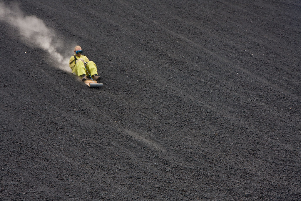
Volcano boarding on Cerro Negro, Nicaragua. Garrett Ziegler. CC BY-NC-ND 2.0.
Bigfoot Hostel in Leon, Nicaragua is one of the only places in the world where you can go volcano boarding. According to their website, volcano boarding is the “thrill of a lifetime.” The hostel’s original owner, Daryn Webb, created the extreme sport, where those brave enough to try it can speed up to 60 miles per hour down the side of an active volcano.
Webb and his crew tested various objects for sliding down the volcano, and after some trial and error, they created a sit-down toboggan made of metal and plywood. The hostel offers daily tours beginning at 9 a.m., with prices at $25 per person. Tours return at 3 p.m.
The Cerro Negro volcano is the youngest volcano in Central America, and is also one of the most active volcanoes in Nicaragua, erupting nearly every 20 years.
Bigfoot Hostel has sent over 20,000 people down Cerro Negro slope at up to 62 miles per hour, and it is known for attracting many sports enthusiats and adrenaline junkies. One of the most famous people to attempt the extreme sport was Eric Barone, who rode down the volcano on a bike at 107 miles per hour in 2002.
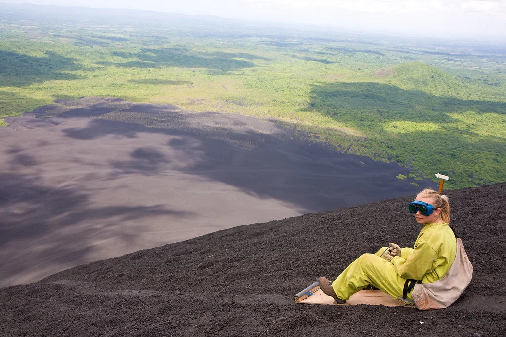
Volcano boarding on Cerro Negro. Garrett Ziegler. CC BY-NC-ND 2.0.
It is possible to slide down the Cerro Negro because the volcano is made of small grain-like volcanic rocks, which came from the crater. In addition, there is almost always a very strong wind hitting the volcano, so it’s the perfect surface for boarding.
Those who have visited before say that they could feel the heat radiating from the volcano and could even cook their meals in a hole dug out in the volcano.
All visitors must wear closed toe shoes and comfortable clothing. Those who have boarded down the volcano before recommend wearing hiking boots (since it takes about 45 minutes to reach the summit) and a multipurpose head wrap to cover your nose and mouth while boarding. Also, take a large water bottle and a GoPro if you want to record the experience.
The hostel offers dorm-style rooms, with rooms with fans at $6 and rooms with air conditioning at $10. There are also private rooms with double, triple, or quadruple beds.
RELATED CONTENT:

Isabelle Durso
Isabelle is an undergraduate student at Boston University currently on campus in Boston. She is double majoring in Journalism and Film & Television, and she is interested in being a travel writer and writing human-interest stories around the world. Isabelle loves to explore and experience new cultures, and she hopes to share other people's stories through her writing. In the future, she intends to keep writing journalistic articles as well as creative screenplays.
VIDEO: South Korea’s Shining City
Seoul, the capital of South Korea, is the country’s largest metropolis, boasting huge skyscrapers, high-speed public transportation and the latest in trends that will soon circle the globe. But this city also holds hundreds of years of history, culture and religion, which have shaped its growth and continue to impact how it functions today and thus how it will work in the future. The geography of the Seoul area is just as varied as its history; director Brandon Li explores the different aspects of the city through captivating shots of the landscape that are juxtaposed with similar-looking modern features. Above all, this video focuses on the residents of Seoul—their daily lives, journeys, work and commutes—to tell a story about the city.
Tibetan Worship and Culture at Lhasa’s Jokhang Temple
Take a visual visit to Jokhang Temple in Tibet, one of the holiest destinations for Tibetan Buddhists, with this magnificent photo essay by Carol Foote. See traditional dress and culture on this pilgrimage route.
Read More6 Interesting Facts about the Egyptian Pyramids
There is still so much we don’t know about the history and structure of the Egyptian pyramids. Here are six things that you may not have known about the pyramids and ancient Egypt.

Egyptian pyramids in the sunset. Club Med UK. CC BY-NC 2.0.
The Egyptian pyramids are famous for their buried mummies and treasures, but there are still many secrets waiting to be uncovered about their history. Take a deep look into the ancient pyramids’ past with these six interesting facts.

The seven wonders of the world, Egyptian pyramids. Boston Public Library. CC BY 2.0.
1. Once upon a time, they sparkled.
According to research on ancient texts and found evidence, it is thought that the Great Pyramid of Giza used to shine like glass and sparkle in the sunlight. Ancient Egyptians even called the pyramid “Ikhet,” which translates to “glorious light.” This is mainly because the pyramid was originally covered in polished limestone which reflected light like a mirror and made the pyramids visible from anywhere nearby. What is even more interesting is that the speed of light—299,792,458 m/s—are also the exact coordinates of the Great Pyramid of Giza, which is at 29.9792 degrees north, 31.1342 degrees east. Spooky? Definitely.
Entering the pyramid. Trey Ratcliff. CC BY-NC-SA 2.0.
2. Many of them were robbed.
A lot of the unknown history of the pyramids can be blamed on tomb robbers. Tomb robbing was a serious problem in ancient Egypt because robbers targeted the tombs for looting—even Kings’ tombs were broken into. It was the Egyptian belief that everything buried with you was taken into the afterlife, so Kings and Queens were buried with unimaginable amounts of riches. It was also very common for people to steal from their ancestors’ tombs —some even dumped the body and stole the sarcophagus. Egypt was a cashless society until the Persians came in 525 BCE, so those who stole from the tombs would have had to trade their stolen goods to higher, corrupt officials. Those caught would be executed for the offense.

The Great Pyramid of Cheops. Boston Public Library. CC BY 2.0.
3. We still don’t know how they were built.
Although the pyramids are over 4,000 years old, professionals still don’t understand how the ancient Egyptians managed to build the pyramids without advanced technology. The most accepted theory is that they used ramps to bring materials to the top, which has been proven by a recent discovery. Researchers in Egypt discovered a 4,500-year-old ramp used to haul alabaster stones out of a quarry. The ramp system dates back to Pharaoh Khufu, who built the Great Pyramid of Giza. However, the way in which the ancient Egyptians built the pyramids is still a mystery because the pyramids were not made of alabaster, which is what the discovered ramp helped to move.

Khufu’s Great Pyramid. Bernt Rostad. CC BY 2.0.
4. There is a secret chamber in the Great Pyramid of Giza (Khufu’s Pyramid).
Weighing in at 5,750,000 tons, the Great Pyramid is simply a feat of architecture. To add further to the mystery, a previously unidentified chamber in the Great Pyramid was discovered in 2017 when physicists used the by-products of cosmic rays to reveal an at least 100-foot long void. The mysterious space’s dimensions are similar to the pyramid’s Grand Gallery, which is the corridor that leads to the burial chamber of Pharaoh Khufu. What lies within the space is still unknown, as well as its purpose. Scientists hope to find out more about this newly discovered area and what it was used for.
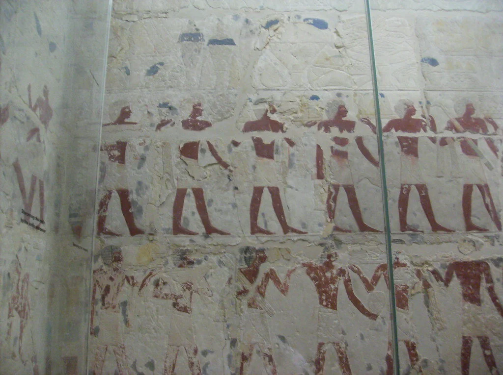
Tomb of Perneb, carving of offering bearers. Peter Roan. CC BY-NC 2.0.
5. It was tradition for the living to share food with the dead.
Ancient Egyptians believed that tombs were eternal homes for the mummified bodies and the ka spirits that lived within them. Each tomb had a tomb-chapel where families and priests could visit the deceased and leave offerings for the ka, while a hidden burial chamber protected the mummified bodies from potential harm. Visitors offered food and drink to the dead daily, and once the offerings were consumed by the ka, the living were free to eat and drink their offerings. The Beautiful Feast of the Valley was an annual festival of death and renewal where families spent the night in the tomb with their ancestors and feasted with them in celebration of their lives.

A statue ofNefertiti in the Altes Museum in Berlin. George M. Groutas. CC BY 2.0.
6. Egyptian women and men had equal rights.
In ancient Egyptian times, men and women of the same social class were treated as equals in the eyes of the law. Women could sell, own, earn, buy and inherit property. If widowed or divorced, women could raise their own children. Women could also bring cases before a court. Overall, women could legally act on their own and were responsible for their own actions. Although everyone in ancient Egypt was expected to marry, wives still had an important, equal and independent role in their marriage.

Isabelle Durso
Isabelle is an undergraduate student at Boston University currently on campus in Boston. She is double majoring in Journalism and Film & Television, and she is interested in being a travel writer and writing human-interest stories around the world. Isabelle loves to explore and experience new cultures, and she hopes to share other people's stories through her writing. In the future, she intends to keep writing journalistic articles as well as creative screenplays.
Siberia's Lake Baikal, One of the Deepest Lakes in the World
Recognized as one of the few remaining ancient lakes in the world, Lake Baikal has preserved natural history and housed thousands of animal species for centuries.

Lake Baikal surrounded by greenery. Markus Winkler. Unsplash.
In Siberia, just north of the Mongolian border, sits Lake Baikal, one of the deepest lakes in the world. The lake houses 22 percent of our planet's fresh water and measures over 5,300 feet deep. Furthermore, its location between mountains allows for over 330 rivers and streams to connect to it, and the lake is made up of three basins. While Lake Baikal only equates to around half the surface area of Lake Michigan, measuring in at about 12,200 square miles, its magnificence lies in its history.
Experts have estimated that the lake is between 25 and 30 million years old, making it one of the few remaining ancient lakes on the planet. This is because it lies in an active rift zone due to its plate tectonics, unlike most other lakes which have a history of being covered by ice sheets in previous glacial periods. Most ancient lakes are formed when the Earth's plates begin to move apart from each other, creating a rift valley that is deepened over time by erosion. Eventually, the rift widens so much that it begins to fill with fresh water. Around 75 percent of Earth's ancient lakes have been formed through this process, with the exceptions having been formed by meteor impacts and volcanic action.
Therefore, not only does Lake Baikal preserve years of Earth's history, but it is exclusively home to around 2,000 unique animal species. Although the lake is protected as a UNESCO World Heritage Site, that hasn’t stopped climate change from affecting the lake, as the surface temperature has increased by 1.5 degrees Celsius over the past 50 years. In conjunction with increasing chemical pollution, the ecosystem is believed to be rapidly changing for the first time in decades.
Throughout the COVID-19 pandemic, locals have been taking advantage of the lack of visitors populating the lake, many beginning to trek out to visit the body of water themselves. Especially during the fall and winter months, many visitors enjoy skating, hiking, or even skiing over the ice and snow.

Ice formed over Lake Baikal. Daniel Born. Unsplash.
Located near one of Russia's largest cities, there has been a constant tug-of-war between developers, locals and environmentalists to seek a balance between encouraging tourism which benefits the local economy, and protecting the deteriorating ecosystem. While the momentary break in visitors has undoubtedly allowed the ecosystem to begin to recover, ultimately its fate lies in the hands of its visitors.
RELATED CONTENT:
PODCAST: Traveling with the Nenet Reindeer Herders in the Siberian Arctic with Patrick Barrow
VIDEO: A Diamond Mine in the Rough

Zara Irshad
Zara is a third year Communication student at the University of California, San Diego. Her passion for journalism comes from her love of storytelling and desire to learn about others. In addition to writing at CATALYST, she is an Opinion Writer for the UCSD Guardian, which allows her to incorporate various perspectives into her work.
Islamic Architecture in Spain
While many can forget that Arab and North African Muslims controlled parts of Spain for almost 800 years, longstanding Spanish architecture is a testament to the Muslim reign. Arabesque patterns, Islamic motifs and sandy colors have been preserved in some of Andalusia’s most famous palaces and fortresses.

Great Mosque of Cordoba, Spain. Richard Mortel. CC BY 2.0.
Arab and North African Muslims conquered the Iberian Peninsula in the eighth century. Ruling for almost 800 years in Al-Andalus (currently Andalusia), Muslims inevitably left traces of their presence in the region. Everything from language and religion to architecture and art was adopted by Spain during the Muslim reign. Around 4,000 Spanish words which are still in use today originated from Arabic. The majority of these words are nouns related to food, animals, nature and science. For example, the Spanish word for “olive” is “aceituna” and is derived from the Arabic word “zaytünah.”
While aspects of the Arabic language can be found in Spanish, Islamic architecture is the true evidence of the Arab and North African Muslim reign in Spain. Certain sites in modern-day Andalusia make you feel like you’re in Morocco or Syria. Today, Islamic architecture is most prevalent in Cordoba, Seville and Granada—Spanish cities in Andalusia—with their palaces and holy sites.
Cordoba

Desert colored walls in the Great Mosque of Cordoba. Waqqas Akhtar. CC BY-NC-SA 2.0.
Cordoba was the capital of Al-Andalus when it was first conquered in 711 A.D. The Great Mosque of Cordoba is a testament to the Arabic and Islamic influence in the city. Elaborate building programs and agricultural projects were sponsored by Prince Abd al-Rahman I from Damascus, Syria. The prince imported plants from Damascus, some of which still stand in the yard of the Mosque of Cordoba today.
Previously operating as a mosque and church at different points in history, the captivating structure includes a hypostyle prayer hall, a beautiful courtyard with an extravagant fountain, a colorful orange grove, a walkway circling the courtyard and a minaret which is now a bell tower. Islamic calligraphy and verses from religious scriptures fill the sandy, red and white colored columns. Geometric shapes dominate the structure—in everything from design to entryways. One major Islamic motif that is evident in this structure is the horseshoe shaped “mihrab.” The mihrab identifies the wall that faces Mecca—Islam’s holiest city that features the home of God, the Kaa’ba—and indicates which direction to face while praying. The mihrab is decorated in gold and brown detailing. Above the mihrab sits a mesmerizing dome filled with pointed gold arches and radial patterns fill the ceiling.


The dome above the mihrab in the Great Mosque of Cordoba. mitopencourseware. CC BY-NC-SA 2.0.
Seville

The Royal Alcazar in Seville is one of the world’s oldest palaces that is still in use today. This palace has been awarded status as a UNESCO World Heritage Site. The Alcazar was first built in the 11th century when the Arabs moved in and sought to create a secure, residential fortress. Since then, Alcazar has been home to the many monarchs who have taken control of Seville. The initially Islamic structure was renovated by its following rulers; however, the palace’s Islamic roots shine through as many of its Islamic components have been preserved.
One of the palace’s courtyards, the Patio del Yeso, was created in the 12th century when the region was still under Muslim control. The courtyard features a large pool in the middle—a common theme in Islamic architecture. Water is at the heart of Islamic architecture for both practical and spiritual reasons. Considering that the Arabs and North Africans came from dry climates and desert landscapes, it was important for them to have easy access to reliable sources of water. Furthermore, in Islam, water symbolizes life and purity. Water in gardens, specifically, symbolizes the sacred lake in paradise that is reserved for only the righteous.
Other recurring Islamic motifs that are found in the Alcazar include keyhole or horseshoe shaped arches, doors and windows; traditional Islamic plasterwork and latticework; Islamic writings; and a heavy presence of plants. The horseshoe arch is known as an “alfiz” and the Islamic-style window screens are known as “mashrabiya.” These, in addition to the icicle-like droppings from ceilings and domes, are common components of modern-day mosques and other traditional Islamic structures.
The gardens of the Alcazar were used not only for aesthetic purposes, but also for functional purposes. While the plants and trees were grown in the palace’s gardens for beauty, the plants were also used to feed members of the court. The gardens themselves were strategically structured to resemble what Muslims imagined paradise to look like based on the descriptions in the Quran.


Garden in the Royal Alcazar, Seville. Jocelyn Erskine-Kellie. CC BY-SA 2.0.
Granada

Alhambra Palace Fortress in Granada, Spain. Victor Wong. CC BY-NC-SA 2.0.
The Alhambra Palace in Granada is further evidence of the Islamic rule in Spain. The name Alhambra itself derives from the Arabic word “Al-Hamra” which means “red.” The palace was given this name for its reddish bricks and walls which can be seen from afar. Alhambra’s layout mimics that of many other palaces for Muslim princes. Three main floor plans dominate the site: the “mexuar” was open to all and the room where sultans received their subjects, the “diwan” is the throne room where receptions were held, and the “harem” is the prince's private quarters. Islamic inscriptions and verses from the Quran flood the walls, while the gold detailing accents the writings.
Mosaics and colored tiles in geometric and plant-like shapes, referred to as “alicatado,” are also in certain quarters. The mosaics are not only decorative but also contain strategically chosen tiles to cool the structure in the summertime. Plant motifs align with Islamic principles, as the depiction of human images is often frowned upon. The Fountain of the Lions in Alhambra is one of the most photographed features of the palace, with 12 lions spewing water in the middle of the courtyard. Other famous aspects of Alhambra which are covered in arabesque patterns and constructed to resemble the gardens in heaven, include the Generalife and El Partal, two of the quieter locations in the palace.

Keyhole shaped windows with arabesque patterns in Alhambra. Güldem Üstün. CC BY 2.0.

Fountain of the Lions in Alhambra. Alexandra Stevenson. CC BY-ND 2.0.

Geometric mosaics in Alhambra. Víctor. CC BY-NC-ND 2.0.
RELATED CONTENT:

Mia Khatib
Mia is a rising senior at Boston University majoring in journalism and minoring in international relations. As a Palestinian-American, Mia is passionate about amplifying the voices of marginalized communities and is interested in investigative and data-driven journalism. She hopes to start out as a breaking news reporter and one day earn a position as editor of a major publication..

VIDEO: A Diary of Senegal
In a departure from typical travelogues, this video shows a unique picture of Senegal through glimpses into everyday rural life with a focus on the children growing up in this beautiful country. Each clip showcases the diversity in landscape, culture, and lifestyle Senegal’s people experience—all bound together by an enthusiasm for life. After watching this video, you’ll want to dance with the people on screen.
5 of the World’s Most Dangerous Hiking Trails
Everyone loves a good hike, but some trails around the globe stand out due to the intense challenges that they provide. The following five hikes should not be attempted by novice hikers.

Aonach Eagach, Scotland. Andrew Marshall. CC BY-NC-SA 2.0.
Hiking can test our physical and mental limits, and is a powerful cardio workout that is proven to boost your mood. While it can be fun to test yourself and get your adrenaline flowing and blood pumping, there are some hikes around the world that can cause serious injuries if you are not careful.
These five hiking trails are not for the faint-hearted and should not be attempted by novice hikers.
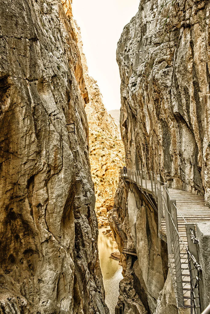
El Caminito del Rey, Spain. Arthur Harrow. CC BY-NC-ND 2.0.
1. El Caminito del Rey, Spain — 4.8 miles
The name of this hike translates to “The King’s Little Pathway,” and it once was one of the world’s most hazardous footpaths. This aerial path is suspended 100 meters high against the walls of a gorge,. It was originally built from 1901 to 1905 between the waterfalls of Gaitanejo and El Chorro to move materials and workers to the local hydroelectric dam. The trail is named “The King’s Little Pathway” because, in 1921, King Alfonso XIII opened it to visitors and traveled along the walkway to the Conde de Guadalhorce dam.
The Caminito del Rey route runs through cliffs, canyons and large valleys. The area is inhabited by a wide variety of plant and animal species, such as Egyptian vultures, griffon vultures, golden eagles and wild boar. The path takes about three to four hours to walk, starting in the town of Ardales and ending in Álora.
The path closed to hikers in 2001 when five people fell to their demise into the river below. Fences were since built into the renovated path and it reopened in 2015.
Cascade Saddle. Tom@Where. CC BY-NC 2.0.
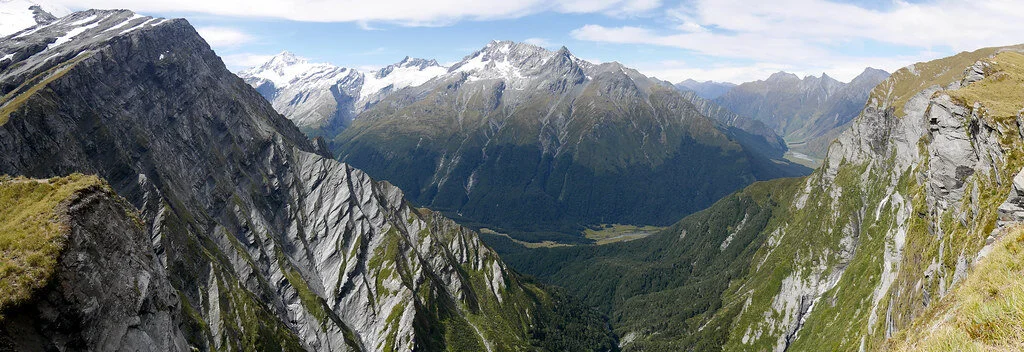
2. Cascade Saddle Route, New Zealand — 29.9 miles
This trek takes almost two days, or four to five days if you choose the expert route. Built in 1939 and located in the Matukituki Valley area and Mount Aspiring National Park in the Otago region, the route travels through scenery featured in the Lord of the Rings films, so many visitors flock to this route for photo opportunities.
The Cascade Saddle route is an alpine crossing recommended for experienced trampers. It is also recommended to hike it only in good weather during the summer. The Department of Conservation advises hikers to begin from the Matukituki side of the route, since ascending is much safer than descending. There are various different routes to take from there.
However, this route can be very dangerous in some parts, where the ground is slippery and unstable—especially when it is raining. Furthermore, there is danger of avalanches from June to November. Check the New Zealand Avalanche Advisory website before you go.
Several hikers have been injured on this trek, and some have even died. If you go, be sure to have the right skills and experience to make the decisions best for you along the trek—you must also bring the proper equipment.
Aonach Eagach ridge. mr__fox. CC BY-NC-ND 2.0.
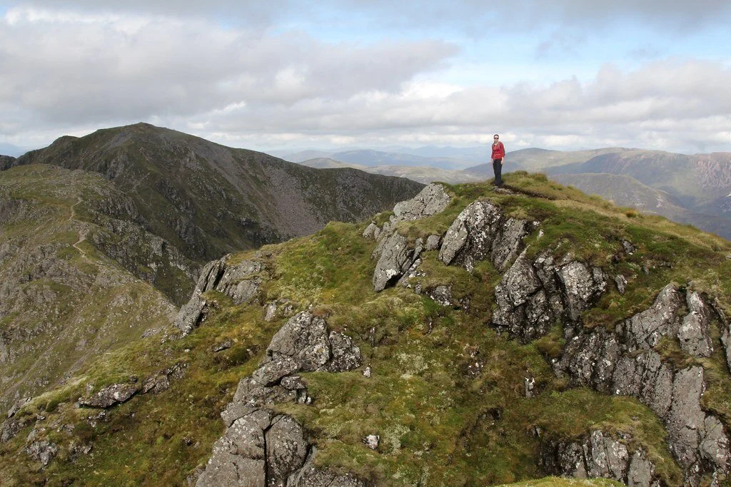
3. Aonach Eagach, Scotland — 6 miles
Located near Kinlochleven in the Scottish Highlands, the Aonach Eagach trail features beautiful wildflowers and mountainous scenery. However, it is also a hard, exposed scrambling ridge between Am Bodach and Stob Coire Lèith. Getting to the summit requires endurance, hard work and lots of climbing. The ridge is 3,126 feet high, making this trail one of the U.K.’s toughest ridge walks.
The trail is only recommended for very experienced hikers in good weather conditions. The rocks can get very slippery in rainy conditions, and side paths are often extremely hazardous and difficult to return from. Over the last 10 years, there have unfortunately been many deaths on the trail, the most recent being in 2017.
The trail is best done east to west, and those who push through the experience are rewarded with the view of a lifetime.
Backpacking in Utah. Zach Dischner. CC BY 2.0.
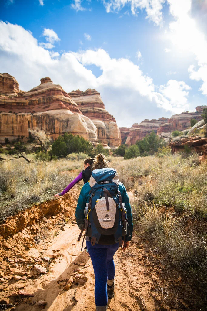
4. The Maze, Utah, USA — 2.9 miles
Although short, trails in the Maze are ancient and lead into various different canyons. Located near Gunlock, Utah, the Maze Overlook Trail requires basic climbing skills in order to navigate steep portions of rock. A 25-foot length of rope also comes in handy to raise or lower packs in difficult spots.
The Maze sees only 2,000 hikers per year since it is so remote and is the least accessible hike in the Canyonlands. The best time to go is in the spring, when temperatures are lower.
The Maze is quite literally a maze of intertwined canyons and dead-ends. The routes do not have beaten trails and they often weave up and over canyons, which are extremely difficult to traverse. Water sources in the Maze are also very limited. Part of the danger comes from how it can take rescuers up to three days to reach hikers because the path is so remote.
The highlight of this difficult and remote path is the view. Hikers will be able to see the Colorado River and Green River converge from atop a massive desert rock in a breathtaking view. Visitors can also see petroglyphs (prehistoric rock carvings) from ancient human history.
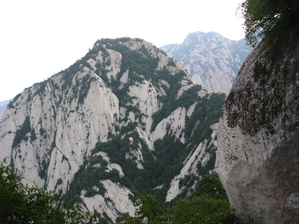
Mount Huashan. Jinjian Liang. CC BY-NC-ND 2.0.
5.Mount Huashan, China — 12.2 miles
Located near Huayin in the Shaanxi province of China, Mount Huashan trails are not very trafficked due to their narrow peaks and dangerous, steep paths. However, the trails feature beautiful wildflowers and scenery, as well as built-in steps and light poles.
Mount Huashan is known to be one of China’s five sacred mountains and one of the most popular pilgrimage sites for Chinese people. It is also considered by many to be the original place of Chinese civilization and is praised as the “Root of Huaxia (China).” The famous plank walk is 7,070 feet high and located on the mountain’s highest peak. There are many different trails to follow in the mountain, but the Changkong Plank Trail is the most dangerous and thrilling. The 700-year-old trail is only 12 inches wide.
The first few miles of the trail are a gradual ascent until Thousand Foot Narrow, and then the trail becomes narrow and steep toward the North Peak. There are many places to stop to experience breathtaking sunrises or sunsets and mountainous scenery. This trail is meant for only very experienced hikers.

Isabelle Durso
Isabelle is an undergraduate student at Boston University currently on campus in Boston. She is double majoring in Journalism and Film & Television, and she is interested in being a travel writer and writing human-interest stories around the world. Isabelle loves to explore and experience new cultures, and she hopes to share other people's stories through her writing. In the future, she intends to keep writing journalistic articles as well as creative screenplays.
Congo Couture: “Sapeurs” Bring Europe’s Designer Fashion to Central Africa
The Republic of the Congo’s world-famous fashionistas strut through the streets of Brazzaville wearing outfits from Europe’s most revered designers. But to sapeurs, their fashion savvy is not just style but a lifestyle.

A sapeur in his Sunday best. ilja smets. CC BY-ND 2.0.
Maxime Pivot makes all the ladies scream. Men call him the pride of the town. Children follow him wherever he goes. The Republic of the Congo has never seen a more dashing, debonair, sharp-dressing gentleman. As a modern-day dandy in the streets of Brazzaville, he is a painterly splash of Congo couture amid near-universal penury. He boasts a double-breasted red suit, a pearl-white shirt, pitch-black sunglasses and a pink bowtie, an outfit to amaze the prim and plebeian alike. Rather than envy, his panache inspires pride. Some may call his focus on fashion amid staggering poverty vain, but really, he is preserving a decades-long tradition. He is a sapeur.
That means that he is a member of the Société des Ambianceurs et des Personnes Élégantes—La Sape for short. In English, it translates to the Society of Ambiance-Makers and Elegant People. Every weekend, he and his fellow dandies meet to compare outfits from the hottest European designers, trade notes on color combinations and revel in the pomp of haute couture. They smoke, they dance and they conversate. They escape the squalor in which so many Congolese live—when sapeurs dress up, they feel like the richest men in the world.
No, they are not rich. Quite the opposite. By day, sapeurs are chefs, mechanics, electricians, craftsmen, businessmen, handymen, journeymen, or any other kind of blue-collar worker. 70 percent of people in the Republic of the Congo live in poverty, and most sapeurs are included in that number. What distinguishes them is not wealth but aesthetic distinction, good taste, and a deep knowledge of the latest fashion trends. They aspire to look like a million bucks, not spend it.

The street is a catwalk. Jean-Luc Dalembert. CC BY-SA 4.0.
The tradition began during the Congo’s colonial period. Congolese servants, tired of wearing their Belgian and French colonizers’ secondhand clothes, began saving their wages and purchasing the latest clothes for European dandies. After serving in the French army during World War II, Congolese soldiers returned home bringing closets-worth of European suits, shirts, ties, shoes and accessories. By the time the central African nation gained independence in 1960, many Congolese elites were making pilgrimages to Paris to rack up designer clothes for their wardrobes back home. Although they were accused of relying on white, “Western” traditions, most sapeurs insist on their artistic independence. As Papa Wemba, one of La Sape’s earliest celebrities, said, “White people invented the clothes, but we make an art of it.”
However, investing in clothes instead of, say, property or livestock can be difficult to justify in one of the poorest parts of the world. Many sapeurs hide their expensive lifestyles from relatives to avoid endangering family ties. If a cousin learns that their family member would rather buy an Armani suit or Weston shoes than help put food on the table, they may feel betrayed and break off relations. Furthermore, the wives of sapeurs tend to bear the brunt of the sapeur lifestyle far more heavily than their husbands, as they suffer the financial cost without being able to revel in high fashion.

European style, African art. Opencooper. CC BY-SA 4.0.
La Sape is overwhelmingly male. Overwhelmingly, but not entirely. As the tradition evolves, more women are staking their claim as sapeuses. They, too, don designer suits from Versace, Dior and Yves Saint Laurent and develop mannerisms and gaits to build a persona around their clothes. Even children are beginning to partake in the sapeur culture. Many worry that Congolese tailors lack apprentices to carry on the tradition, so the sight of a child strutting down the streets of Brazzaville in an Armani suit assures them that the legacy of La Sape will continue.
In fact, Maxime Pivot established an organization, Sapeurs in Danger, to preserve the tradition of La Sape, which he asserts is not just about fashion but also is a way of life. When committing to the lifestyle, sapeurs adopt a code of conduct which Ben Mouchaka, another famous sapeur, summed up in 2000. He calls it the Ten Commandments of Sapeology.
1- Thou shalt practise La Sape on Earth with humans and in heaven with God thy creator.
2- Thou shalt bring to heel ngayas (non-connoisseurs), nbéndés (the ignorant), and tindongos (badmouthers) on land, under the earth, at sea and in the skies.
3- Thou shalt honour Sapeology wherever thou goest.
4- The ways of Sapeology are impenetrable for any Sapeologist who does not know the rule of 3: a trilogy of finished and unfinished colours.
5- Thou shalt not give in.
6- Thou shalt demonstrate stringent standards of hygiene in thy body and clothes.
7- Thou shalt not be tribalistic, nationalist, racist or discriminatory.
8- Thou shalt not be violent or insolent.
9- Thou shalt abide by the Sapelogists’ rules of civility and respect thy elders.
10- Through prayer and these 10 commandments, thou, as a Sapeologist, shall conquer the Sapeophobes.
Maxime Pivot aims to pass down the tradition of La Sape to any man, woman, or child willing to devote themselves to the lifestyle. He operates a school of La Sape where he teaches aspiring sapeurs how to combine colors tastefully and craft a swaggering gait. His classes teach that La Sape needn’t sap their wallets. As the sapeur life and style spread, he hopes that dandies will don local brands, not just expensive European ones.

Innovating a classic style. Makangarajustin. CC BY-SA 4.0.
Then, La Sape could be truly independent from European designers. Fashion trends have been increasingly moving in that direction, thanks to Maxime Pivot’s efforts, especially now that La Sape has moved into the mainstream. Every August 15, the Republic of the Congo’s independence day, sapeurs march alongside the military, indigenous tribes and even the President in the largest parade of the year. Their flashy clothes and sauntering stride draw cheers from the crowd. Their tradition provides an example of how the country can emerge from an oppressive European past and spring into a liberated African future.

Michael McCarthy
Michael is an undergraduate student at Haverford College, dodging the pandemic by taking a gap year. He writes in a variety of genres, and his time in high school debate renders political writing an inevitable fascination. Writing at Catalyst and the Bi-Co News, a student-run newspaper, provides an outlet for this passion. In the future, he intends to keep writing in mediums both informative and creative.
Despite Economic Crisis, Lebanon's Landscape Stands Strong
Lebanon is in one of the world’s worst economic depressions since 1850; however, the nation continues to stand strong with its beautiful landscapes and soulful culture.

Lebanon—former French colony and home to the “Paris of the Middle East,” Beirut—has stood strong between nations riddled with tragedy. With Syria on its Northern and Eastern borders, Israel and Palestine on its Southern border and the Mediterranean Sea to the West, Lebanon was frequently extending a helping hand to its war-torn neighbors. However, in recent years, Lebanon has plunged into a deep economic depression and is riddled with tragedy itself.
With 18 state-recognized religions in Lebanon, it is the most religiously diverse country in the Middle East. However, because religious leaders and political leaders are not mutually exclusive in the sectarian society, this diversity has led to public animosity toward the corrupt government. Although tensions have been brewing for years, the former government’s WhatsApp tax in late 2019 was the tipping point for Lebanese nationals and residents. Protests provoked by the tax broke out across the country and world, calling for a reformed Lebanese government.
Ambushed by the coronavirus a few months later, the Lebanese people experienced immense tragedy in 2020 when one of the world's largest non-nuclear explosions shook the Port of Beirut, leaving more than 200 dead and thousands injured. Lebanon is still haunted by the blast and is struggling to rebuild its destroyed neighborhoods amid COVID-19 and, according to the World Bank, one of the world’s worst financial crises in more than 150 years. To top it off, Lebanon has yet to create a new government since the government of Prime Minister Hassan Diab resigned due to public pressure following the explosion.
Currently, the U.S. State Department advises against traveling to Lebanon due to the large presence of COVID-19 in the nation, the threats of violence and the U.S. Embassy in Beirut’s limited ability to support U.S. citizens. Despite these warnings and Lebanon’s current crises, the people still hold their flag up high and are proud of the beautiful scenes and experiences their country has to offer.
Mountains, beaches, city lights—not only are all these scenic views found in Lebanon, but they are all less than an hour-long drive from one another. Lebanon’s landscape is especially unique because of the country’s small size. Residents and tourists alike can enjoy in a single day these three entirely different scenes and the activities associated with each of them.

There are two main mountain regions in Lebanon—Mount Lebanon and the Anti-Lebanon Mountains. Mount Lebanon extends across the entire country, while the Anti-Lebanon Mountains form the border between Lebanon and Syria, seeping more into Syrian territory. Snow-peaked year-round, Faraya, a village in the Keserwan District of the Mount Lebanon Governate, is one of the best ski spots in the country. Faraya, positioned at an elevation of 3,900 feet to 7,000 feet, is around 25 miles northeast from Beirut and around 23 miles southeast from Byblos, one of the oldest cities in Lebanon which sits on the Mediterranean coast.


“Miracle Monk of Lebanon,” Saint Charbel. DerekL. CC BY-NC-SA 2.0.
Populated primarily by Maronite Christians, Faraya holds the largest statue and church of Saint Charbel in the world, standing 75 feet tall and around 30 feet wide. It is said that St. Charbel resided in this former monastery for over 20 years and those who visit and ask for assistance hear back. Since 1950, the “miraculous healings” of St. Charbel have been tallied and, as of mid-2019, the number lies above 29,000. Miracles were verified by priest witnesses before 1950; however, since 1950 and the advancement of medical technology, all “miracles” require medical proof for verification.

With Mount Lebanon paralleling the Mediterranean sea, the mountains are never too far away from the beaches. Along Lebanon’s coast lies hundreds of public and private beaches. One of the most famous public beaches in Lebanon is Joining Beach in the coastal city Batroun. With water so clear and blue it looks like it was dyed, Joining Beach is the perfect place to explore marine life. Underwater activities like snorkeling and scuba diving are common at this Lebanese shore.

Jeita Grotto. kcakduman. CC BY-NC 2.0.
Beyond swimming and sunbathing at the beach, Lebanon’s coastal towns show off wonders of nature. In Jeita Grotto, located 11 miles from the capital city in Jeita, exists a system of two interconnected caves that are around five and a half miles long. The upper galleries of Jeita Grotto is home to the world’s largest known stalactite—a mineral formation that hangs from the ceilings of caves—and was one of the top 14 finalists for the New 7 Wonders of Nature competition in 2011.

Beirut, Lebanon. marviikad. CC BY-SA 2.0.
Beirut, the heart of Lebanon, has its own natural wonders to show for as a big city in all its glory and flashing lights. Populated with restaurants, clubs and bars, Beirut’s nightlife is like none other in the Middle East. Alive all night, Lebanon’s pride and joy offers an experiential party scene. With clubs like Sunrise Beirut, partygoers start their outing as early as 10:30 p.m. and dance to techno until the sun lights up the sky. Mar Mikhael, named after the Maronite Catholic Church of Saint Michael, is a neighborhood in Beirut that is known for its aesthetic dining options—restaurants, cafes and bars are all fashionable outings in Mar Mikhael, the art hub of Beirut. Stationed on the marina, Zaitunay Bay is another classy area to shop, eat and be mesmerized by Beirut’s soulful city lights.
It’s true, Lebanon is still in crisis; however, the soul of the country lies within its people and landscape—both of which are beautiful, strong and resilient.
RELATED CONTENT:
PODCAST: Social Entrepreneurship in Lebanon

Mia Khatib
Mia is a rising senior at Boston University majoring in journalism and minoring in international relations. As a Palestinian-American, Mia is passionate about amplifying the voices of marginalized communities and is interested in investigative and data-driven journalism. She hopes to start out as a breaking news reporter and one day earn a position as editor of a major publication.